
Its been great fall weather the past few days. However all that is about to change. We are watching another developing system coming from our west that will give way to more wet and windy conditions across the midwest. You can already see our Wednesday system developing on radar. Take a look at this radar and surface image below.

All that rain on radar you see in the left yellow box is whats developing for Wednesday into Thursday. You can also see the cold front that will define this system in the surface chart to the right. This is a strong low pressure system. Much like earlier in the week when we saw 44mph wind gusts in Lafayette, this will be another high gusty wind event!
Here's the break down on how this system currently looks to play out over Wednesday afternoon into Thursday.

Starting out with scattered rain showers across the area Wednesday afternoon we will see that cold front near the area.

As we head into later Wednesday evening / night we will see the much heavier bands of rain move through the area. As you can see in this model above. We're expecting rainfall between .50" inches and 1.50" inches. Maybe even slightly higher amounts in areas that see thunderstorms.We could see winds blowing between 10 and 20 mph gusting between 25 and 38 mph at times. Though I don't see anything severe in this system for our area. Gusty winds and heavy rain seem to be the main threat.

We will see a slight break in the rain and clouds as we form a dry slot in this system later on Thursday morning / early afternoon before that second half of the system catches us. You can see the dry slot in this model image above.
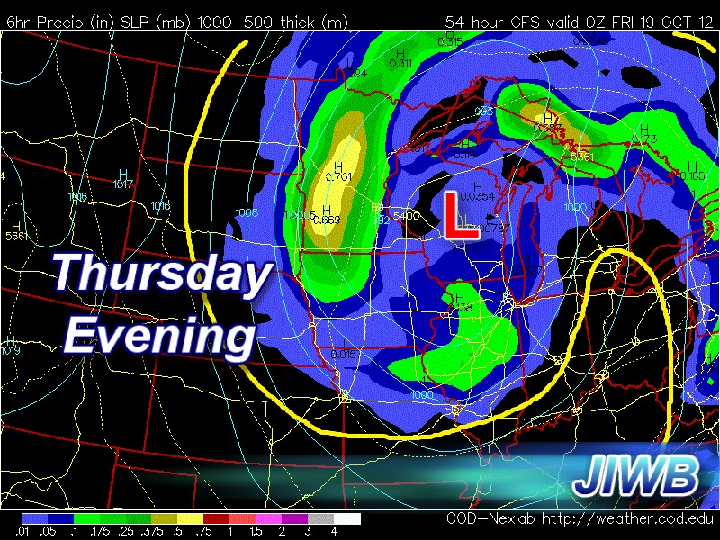
Thursday evening the clouds roll back into the area bringing whats left of the system. Scattered showers and a few gusty winds to 25 mph likely. Much cooler air will be in place Thursday and Friday after that cold front pushes through. Highs only in the 50s! As few spotty showers will linger into Friday off and on through out the day.
This storm almost looks like a hurricane on land. Its so big, it really is incredible looking!
Here's your forecast below.

WEDNESDAY- We will start out with partly cloudy skies across the area. Clouds and rain will move in as we head into the afternoon hours. Expect a high around 73* degrees with winds between 10 and 20 mph.
WEDNESDAY NIGHT- We will see rainy and windy conditions across the state. Rain will be heavy at times along with winds gusting to 25 and 38 mph. Look for a low around 42* degrees. Rainfall between .50" and .75" inches.
THURSDAY- We will see rain showers in the early early morning. However that will try to tapper off as we hit late morning. We will form a dry slot in this system giving way to partly cloudy skies during the afternoon hours. The second round of scattered showers will move into the area later on in the afternoon / early evening. Look for a chilly high around 59 * degrees and a low around 43* degrees. Winds between 10 and 15 mph gusting to 20 and 25 mph at times. Total rainfall between Wednesday and Thursday is looking between .50" and 1.50" inches. Slightly higher amounts in any thunderstorms.
EXTENDED OUTLOOK- Still some lingering spotty showers as we head into Friday. Otherwise mostly cloudy skies across the area. Friday will be another chilly day with a high in the lower to middle 50s. 50s and 60s will be our high as we finish off the work week. Clearing skies near the weekend!
3 comments:
Thanks for the info and welcome back!
No problem, Yeah I've been trying to get things going on here again. Sorry for the long set back.
Great read thanks
Post a Comment