Thursday, December 20, 2012

Developing...

I'm going through data right now bloggers. I will have a look at the latest possible snowfall totals very soon. Details coming up!
 
Stay Tuned!
 
DEVELOPING..........

Wednesday, December 19, 2012

Great Way To Kick Off The First Official Day Of Winter! First Snow Of The Season On The Way!

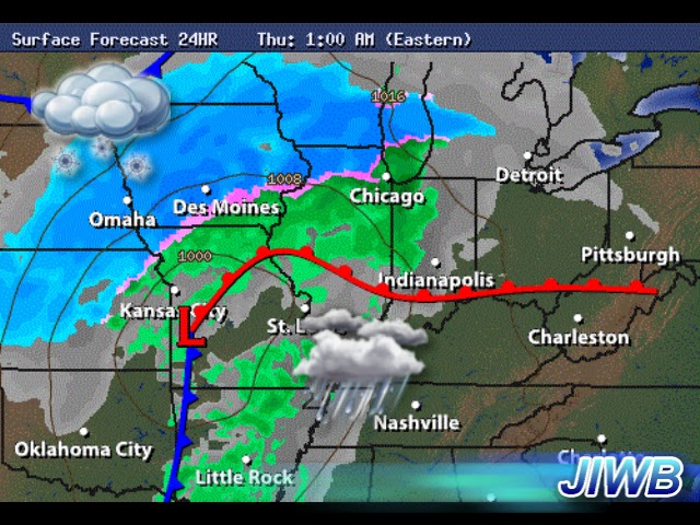
What you're looking at above is one of my favorite weather models to use during winter weather. And guess what those beautiful blue bars mean on this image!!!!! SNOW! Yes, we're tracking a big weather system that will move in by as soon as midnight / 1:am tonight.We have a strong low pressure system that will give way to blizzard contitions across parts of the midwest over the next few days. We're not looking for anything of that magnatude in our area, however some heavy rain changing over to snow is in our future.
 
Here's a look at the system we will be tracking over the next day or two below.
Right now we are expecting to see rain move in sometime after midnight tonight. Rain will go through out Thursday until later that evening when it starts to change over to some snow showers. By the time we're finished with the rain, we could very well have picked up between .50" and 1" inch of rainfall.
(Image looking into 1:am EST Thursday).
 
Right now I'm expecting that rain to snow change over to be sometime around 6:pm or 7:pm EST Thursday. Give or take a little.
Above is a look at a surface chart looking into 7:pm EST Thursday. We will see that cold cold polar air wrap around into our area with a high starting out on Thursday at 50* degrees falling as the day continues. Only to end up with a low that night of 24* degrees! Snow showers would continue into the Friday morning hours before tapering off that late morning / early afternoon.
 
So how much snowfall am I currently expecting across the area? Well, take a look below.
Now remember that these numbers are simply a range of what we could see. I'm currently looking for areas around I-70 to pick up around an inch of snowfall possible. Central Indiana around the Lafayette, area to pick up between .50" and 1.50" inches. The Bufkit models are showing the likely hood of 1.3" inches of snow for the Lafayette, area at this time. With heavier snow at times the more north you go in areas of Newton, and Jasper, counties where I'm calling for a more wide area of 2" to 3" inches possible.
 
I will continue to go through data as much as possible to keep you all posted. I will try to update these number later on tonight after work. So stay tuned and get winter ready! What a great way to kick off the first official day of winter (Dec 21st).

Sunday, December 16, 2012

Are You Dreaming Of A White Christmas?

Can you believe it is only 8 days til Christmas? Its coming very very fast. This is crunch time not only for the last minute shoppers but also for any meteorologist. The weather models are lighting up like lights on a Christmas tree. We have so much going on this week that could be the difference between a white Christmas and a green one. But before I get to that lets go ahead and look at whats in store for tonight.
I'm currently looking for dew points to drop around 35* degrees with an air temperature tonight around 36* degrees. So a foggy night / early Monday morning will be in the cards. Allow extra time to get where you need to be and be careful if you're out and about.
 
As we head into Monday we will look for mostly cloudy skies across the area with a high around 48* degrees. Winds will be light between 10 and 15 mph. Rain showers will try to move into the area later on Monday afternoon / evening. Rainfall will be between .10" and .25" inches. Expect a low around 32* degrees.
 
Tuesday we will see partly cloudy skies across the area with a mild high around 50* degrees. A low that night falling to 35* degrees. As we look ahead into later this week I do see temperatures trying to get back around normal after Thursday the 20th. Much cooler air will try to filter in.
~~~~~~~~~~~~~~~~~~~~~~~~~~~~~~~~~~~~~~~~~~~~
 
So how about our snow chances for Christmas? Well, right now we have so many different model readings telling us different things. I really cannot set anything in stone just yet. However I do agree with the National weather service's thoughts on our chances of a white Christmas.

Above is a chart showing our White Christmas snow chance. You can see we're keeping that 60% to 75% and 90% percent chance well north of our area. With Indiana, and much of the lower midwest in that 25% to 40% percent chance. You may think "25% to 40% percent is a pretty wide window?". And you're right! However at this time the models are still unsure how things'll play out.
 
Right now we have colder air that will try to filter in as we head into December 20th. Once this happens we will also have at least two shots at some snow showers in the area before Christmas. The question is "Will it be enough for coat the ground?". We have a chance of snow showers in the area between December 20th and the 21st, with another chance of some snow showers on Christmas eve. Things are to inconsistent at the moment to set any forecast in stone. I have watched these systems change so so much over the past few weeks. All we can do now is continue to watch them closely and forecast them as best to our ability as we can with the information we currently have. This is why we currently have such a wide window with that 25% to 40% percent chance of a white Christmas. I will be able to dial this forecast in much more as we head closer to the big day!
 
Here are a few snow extremes from Christmas Day's past:
Greatest Snowfall on Christmas Day
Greatest Snow Depth on Christmas Day
5.9” in 1909
9” in 2004
4.4” in 1926
7” in 2002
3.3” in 1890
7” in 1909
2.6” in 2005
6” in 1995
2.4” in 1935
6” in 1935


Have a great day bloggers. I will check back real soon.


Wednesday, December 12, 2012

White Christmas? Watching two systems over the next few weeks.

Christmas is getting closer everyday and the month of December is an active one weather - wise. We have two more systems to watch between now and Christmas. One of which will be a warm weather system with precipitation in the form of rain. The other one could very well be our first snow of the season!
 
I don't want to give a full peak into our Christmas forecast just yet as its still subject to change. This system I have been tracking over the past few days has already changed at least two different times. So nothing is set in stone just yet. However I will have details on your Christmas outlook very soon.
 
Here's a look at the timing of when the next two systems can be expected.
That first system can be expected between the 15th and 16th. A warm weather system with lots of rain. The second system is the one I'm tracking over Christmas time. Some models show it heading in between Christmas eve and Christmas day, while other models have it moving in a little slower between Christmas night and December 26th. So this is one we'll have to watch over the next few days very closely! This is the system that will either give us a white Christmas or a green one.
 
Here's a look at how the weather conditions looked last year in Lafayette, IN over Christmas time below.

LAFAYETTE PURDUE UNI

Temperature

Minimum Temperature

32.0 °F

Mean Temperature

37.2 °F

Maximum Temperature

46.0 °F

Pressure and Dew Point

Mean Sea Level Pressure

30.22 IN

Mean Dew Point

28.6 °F

Precipitation

Total Precipitation

0.00 IN
Rain and/or melted snow reported during the day.

Visibility

10.0 MI

Snow Depth

No data.

Wind Speed and Gusts

Mean Wind Speed

10.47 MPH

Maximum Sustained Wind Speed

20.00 MPH

Maximum Wind Gust

29.92 MPH
~~~~~~~~~~~~~~~~~~~~~~~~~~~~~~~~~~~~~~
~~~~~~~~~~~~~~~~~~~~~~~~~~~~~~~~~~~~~~~~
As for our weather tonight.
We have a COLD night ahead as the skies will be clear allowing that cold air to filter in giving us a low of only 24* degrees. Winds will be light between 10 and 15 mph.
 
I will keep you posted on our Christmas forecast. Have a great day bloggers.

Monday, December 10, 2012

Blizzard video from MN, and SD.

The system that gave way to all our rain over the past few days has lifted northeast. This system that gave way to heavy rainfall at times across Indiana, is also part of the same low pressure system that caused blizzard conditions in areas to our northwest in MN, and SD.  Heavy  heavy snowfall with winds blowing to 40+ mph. here in Indiana we saw a few light snow flurries this evening however nothing even close to what I like about winter.

I have a few weather videos from both MN, and SD, below. Armature video uploaded to youtube from first hand eye witnesses. Take a look. 
Blizzard of the year in places of Minnesota. You can see people trying to dig out of over 18" inches of snow across parts of Minnesota. This storm has left its mark on anything in its path. Roads especially! It has been a nightmare for roads crews trying to keep up with the accumulating snow. Many accidents have accrued over the past few days do to the slick snowy / icy conditions.

Here is another look at this dangerous blizzard from the SD, side of things.
Brookings, South Dakota Blizzard 2012.
They didn't have any snow before this blizzard blew through. This is two days of continuous snow and 40mph winds. It stopped when it when about knee deep. With winds of 40+ mph and snow this deep, it can easily drift several feet high! I've measured 4" inches of snow here in Lafayette, IN before that has drifted into 12" and 15" inches in areas! It can get pretty crazy. I pray that everyone stays safe and practices caution during this major snow event.

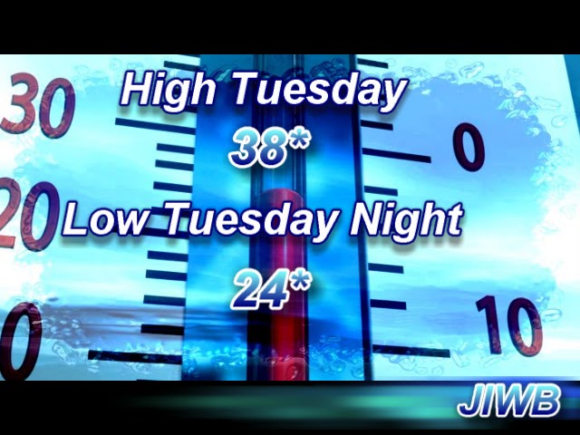
So what about us here in the Midwest? well, we will have a COLD Tuesday with highs only reaching 38* degrees at the most. Along with a low Tuesday night around 24* degrees!  
We will have a brief warm up as we head into the middle of this week where highs could reach the upper 40s to low 50s once again. Looking ahead into the next few weeks we will watch a few more systems trying to develop and move into the area. I will have a post soon talking about the current storm track and if we will see a white Christmas here in Indiana this year. We have so many questions and not enough answers right now. So I will continue to go through data and keep you posted as much as possible. Have a great night bloggers. God Bless!