
We have some weather changes on the way bloggers. It's been a wet few days with our mini melt down weather - wise. All that snow we had got washed away with the rain. The ground is soggy but its nothing compared to what we have ahead of us! Flood watches and warnings already in effect just from our snow melt and rain this week. With even more rainfall on the way.
...A FLOOD WARNING CONTINUES FOR PORTIONS OF THE FOLLOWING RIVERS...
BIG BLUE RIVER...DRIFTWOOD RIVER...EAST FORK WHITE RIVER...EEL
RIVER...MUSCATATUCK RIVER...WABASH RIVER...WHITE RIVER...
BIG BLUE RIVER...DRIFTWOOD RIVER...EAST FORK WHITE RIVER...EEL
RIVER...MUSCATATUCK RIVER...WABASH RIVER...WHITE RIVER...
~~~~~~~~~~~~~~~~~~~~~~~~~~~~~~~~~~~~~~~~~~~~~~~~~~
You can see in this image below how the Wabash River is looking and is expected to look after the rain this week.

You can see we're currently standing at 8.52ft. We're expected to peak at 1:am EST Tuesday at 13.7ft. Minor flood stage is at 11ft so we will be a good 2.7ft above flood stage! If you live by the rivers this is something to take note of over the next few days.
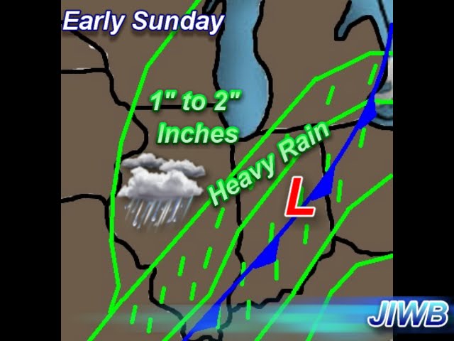
Above is looking at a surface chart into Early Sunday morning. We will be tracking a strong low pressure system through the area giving way to some heavy rain at times. We could easily see rainfall between Saturday night into Sunday morning between 1" and 2" inches!
Here's your weather break down below.

Tonight we can expect to see clouds move into the area later this evening. Followed by rain showers into Sunday morning. Winds will be between 5 and 10 mph to 10 and 15 mph at times. Look for a low tonight around 34* degrees.
Sunday we will start the day with a rain to rain snow mix. Total rainfall between tonight and Sunday will be between 1" and 2" inches in areas. Winds will be between 10 and 15 mph. Expect a high Sunday around 38* degrees and as that cold front passes through we will drop to a low that night of 17* degrees! Winter is back!
Monday we will look for clearing skies through out the day with a cold high around 29* degrees. Even colder that night with a low around 17* degrees. Bundle up!
So as for next week here's what we'll have to keep an eye on!

Cold temperatures will filter back into the state as we head into next week with increasing chances for a few Alberta Clipper systems in the area. some models indicate an active pattern setting up for Alberta clippers. So we will watch that.
That's it for now bloggers. Enjoy the nice weather today before things get cold and soggy once again.
God Bless!


