Wednesday, January 30, 2013

Dangerous Wind Chills!

Take a look at the final rainfall totals from around the area this morning. Everyone coming in with over an inch of rain. 2.05" inches fell in areas of Jasper county up around Rensselaer. 1.73" inches in Logansport. Along with 1.36" inches in areas of Lafayette and 1.10" inches fell across Fountain, county in the Covington area.
 
The National weather service does have a Flood Warning issued for portions of the following rivers.
EAST FORK WHITE RIVER...MUSCATATUCK RIVER...WHITE RIVER...WABASH
  RIVER...EEL RIVER...
Now as we head through out today we will continue to see our temperature fall. We will see a low tonight of 16* degrees! Winds will be blowing between 15 and 20 mph gusting between 25 and 30 mph. Very blustery tonight, wind chills will be something to keep an eye on over the next few days. With winds gusting to 30 mph and a low expected to be around 16* degrees tonight it will make things feel much colder. Wind chill values tonight will be between -5* and -7* degrees. Bundle up!!
If you think tonight is going to be cold, just you wait! Tomorrow will be EVEN colder. I'm expecting a high Thursday of only 21* degrees. A low Thursday night of 1* degree. Winds will be between 15 and 20 mph gusting to 25 mph at times. This will make for a nightly wind chill anywhere between -15* and -20* degrees. This is dangerous wind chills. I'm talking about frostbite possible in 30 minutes! Please take caution and dress very warm.
You can see all the cold air I'm talking about in this image above. we will have a chance for a few light snow flurries in the area as we head into tonight and possibly tomorrow. Nothing much. The cold will remain our big topic over the next few days! So do your best to keep warm bloggers. Take care and God Bless!

Tuesday, January 29, 2013

Thunderstorms tonight, followed by a big temperature drop off tomorrow!

Highs in the 60s today. In January!!! Well, we're about to pay for it. It's like I have always said, Mother nature is like I big rubber band. The more you pull it from its natural state (Meaning normal highs, lows, weather patterns, etc) the harder it snaps back to normal! And that's what we're about to do.
 
Above is a look at the radar image at 7:pm EST. We're tracking some thundershowers to our west out ahead of a strong cold front. This will be the story into the overnight hours. We are in a slight risk for severe weather however I'm thinking that most of the severe weather will stay in southern Indiana and then farther south from there. Still a stray strong cell cannot be totally ruled out at this time. Otherwise I believe our main threats tonight will be heavy heavy rainfall which could lead to some isolated  localized area flooding. As well as high gusty winds in and out of storms!
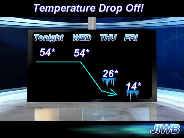
Above is a look at a surface chart for 1:am EST tonight (Wednesday). You can see that cold front moving in. Notice all that COLD and snow just to the west of this front! This is the January weather fighting back with a vengeance! Our low tonight of 54* degrees will be our high tomorrow. Instead of warming through the day our high will be falling! Take a look at the forecasted highs over the next few days below. Its a big temperature drop off..
Get ready bloggers. Stay weather ready, or should I say (Stay temperature ready). Its so hard to get use to this kind of weather pattern, its no wonder everyone keeps getting sick across the area.
 
I'll check back as needed with weather updates! Take care and as always, God Bless.

Wednesday, January 23, 2013

Its been awhile

Just wanted to stop in and let you all know that I'm very sorry I haven't posted in a short while. I have been very sick with the flu over the past few days. This flu is going around like crazy, I've already had two different kinds :/ I'm trying to get well again and I will hopefully be back on here very soon. Take care bloggers. God Bless.

Thursday, January 17, 2013

Coldest its been all winter! Lows near zero before wind chill!! Budnle UP!!

We will see a brief warm up over Friday and Saturday as a quick moving warm front pushed through the area bring some highs in the middle 40s to low 50s possible. Partly cloudy skies across the area. This is all just before we see the deepest cold set in of the season! Our coldest days are ahead temperature - wise.
Above is a look into Saturday's high which will be our warmest day this week, our warmest day for a while really. Highs in the lower 50s likely with partly cloudy skies.
 
Saturday night we will start our cold temperature trend with a low falling to 13* degrees! Brrrrrrr is right.
As we head into Sunday through Tuesday we will see highs only in the teens and 20s with lows in the single digits across the state. Wind chills will be below zero! We will have to watch that very closely. I just went out and got some new gloves for me and my loving girlfriend. Gotta stay one step ahead of the weather!
Looking into Monday's high in this temperature chart above you can see we're only hitting a high around 14* degrees! Just crazy cold!! Monday night will be one of our coldest nights with a low falling to 5* degrees or colder in areas. Remember this is without wind chill. This is the actual forecasted temperature! Wind chill will be well below zero.
Looking ahead we do have a few chances at some small Alberta Clipper systems in the area as we head into next week however I'm not seeing anything big at this time. The deep cold is our main topic this week. So bundle up and do your best to stay warm! Go ahead and throw a few blankets in the back of your cars just in care.
 
Take care bloggers and God Bless!

Deep cold setting up. Coldest we've been all winter!

We have a deep deep cold about to set in over the next few days! I'm talking about the coldest we've been all winter long! Highs may not even reach 20* degrees. I'm going to work on some details for this forecast and will have more answers up for you all very soon. In the mean time go ahead and find your heavy heavy coats, hats, gloves, etc. Brrrrrrrrrrrrrrrrrrrr
 
Stay Tuned!