Tuesday, April 19, 2011

Watching The Caps Pop!

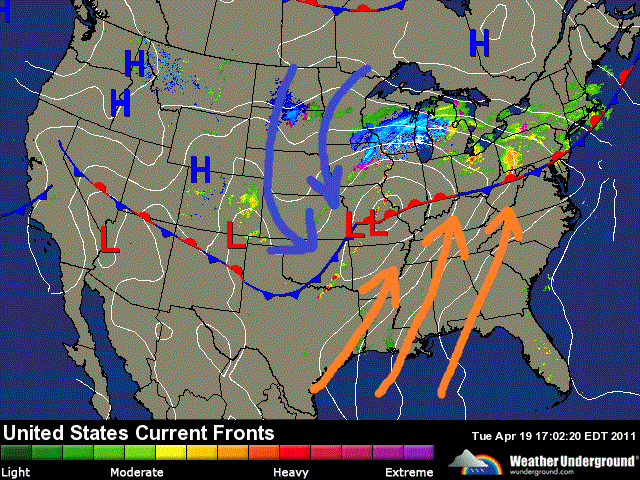
Well, data is still pretty much showing what I have already talked about in my last post however at this time I'm still thinking that the biggest tornado threat will be from I-74 south! However with that said take a look at this below.
Yes, we are starting to see those caps popping along that cold front! Just look at the storms blowing up to our south! Just amazing on the satellite!
Here is another look just a bit farther north around the IL, area. Things are really starting to pop. Right now current data shows that we are rather stable at this time however future data is expecting us to become more unstable as this low pressure system gets closer and our caps begin to pop as well.

So what is a cap? Let me see if I can break it down a bit for you.
This map above is looking at where that warmer air aloft is and where that cold front is set up. Right now we have that warmer air aloft that is keeping us stable. However once this warmer air gets lifted away it will allow these storms to start popping across the area! Just like we're seeing to our west and southwest in the satellite images above. Think of it as a bottle of soda. When you shake it with the cap on nothing happens other then a lot of pressure build up. But once that cap gets removed the soda blows up out of the bottle.

Right now I still look for the highest severe threat to be from I-74 south at this time. Meaning the best place for tornadoes to develop. The more south and southwest you go the higher the threat!
But we're not out of the woods. I still will not rule out the chance of an isolated tornado at this time. However wind damage is also a big threat! winds gusting to 30 mph possible outside of storms and even higher in storms. Also frequent lighting and a few hailers are likely in the area. Heavy rainfall and flash flooding is a threat tonight. Rainfall between 1" and 2" inches with locally higher amounts in thunderstorms.

I look for the storms to be popping around the area between the times of 8:pm and 2:am EDT. It's gonna be a late night on the blog bloggers!

I'll continue to check back as needed with updates!

God Bless!

When Next Update Will Be Posted!

See my last post for the current info on this developing storm tonight. Also I will be back with another look at the latest data closer to 5pm / 6pm EDT so be sure to check back for that! Again at this time I'm still keeping the greatest tornado threat from I-74 south. However I'll have more details on that this evening!

Developing.....

Severe Weather Threat Tonight! Everyone Should Take Note And Be Storm Ready!

Severe weather is on the way tonight bloggers. Lots to talk about and the blog will be booming as the storms move closer!! This is so far the biggest severe threat of the season we have seen this year. I'm looking at the latest weather models showing me CAPE values around 1,500j/kg to 2,000j/kg which is unstable! Supporting hail and dangerous lightning in the area! Also Lifted index around -4 to -5. Anything lower then -4 is very unstable! Also EHI values are looking to be around 3.0 to 3.75! Which is very unstable and does support the chance for a few isolated tornadoes in the area. So I cannot rule them out this time around! Take a look at the severe threat maps below.

HAIL THREAT!

WIND THREAT!

TORNADO THREAT!
Granted the more south you go the stronger and more wide spread the severe weather will be however we are not by any means out of the woods! We need to take note of this developing weather and be storm ready! I'm looking at winds gusting to near 30 mph outside of storms possible. Also 1" to 2" inches of rainfall is likely! With locally higher amounts in storms. A few hailers and or isolated tornadoes cannot be ruled out. So that the latest at this time bloggers. We will just continue to take this hour by hour and do our best to keep everyone updated!

Stay safe!

God Bless!

Friday, April 15, 2011

Weekend Outlook!

Hey bloggers, it's been a little while since I last checked in with everyone! Sorry for that, It's starting to get into that time of year when things start to warm up which means more work for myself lol. I'm still trying to keep updates on the blog so please continue to check back off and on through out the weeks.

Right now there is a strong cold front moving across the states which has given way to some pretty strong storms in areas! However no severe storms for us this time around to worry about thank goodness! This cold front has set up farther south this time around keeping the severe weather away from us!
There are a few storms developing in a line heading into southern IL, and that could effect parts of southern Indiana, however I think we will miss out on any severe weather this time around here in the WLFI viewing area. You can see in this image above where all the strong stuff is taking place this evening. Also with a low pressure system as strong as this one has been we are seeing lots of gusty winds around the area. The national weather service has even issued a few wind advisories in some of our northern counties such as Cass, and White, counties. This advisory is in effect until 10:pm EDT tonight. This is in effect because winds could gust to 25 - 35 mph in these areas at times!

We will see this low pressure system continue to make its way east over the next few days. We are in a break in the rain for now however as we head into Saturday we will start to see that scattered rain fill back into the area as the low pressure system gets closer. Take a look at this surface chart below.
This is looking at Saturday afternoon around 2:pm EDT. You can see just some off and on scattered showers are expected. Rainfall between a tenth and a quarter inch at this time. We will see winds breezy as that low pressure system nears the area with steady winds between 10 and 15 mph gusting to 20 - 25 mph near 30 mph at times. Expect a high Saturday around 54* degrees as that cold front passes the area. Our average high for this time of year is right around 60* degrees.

We will continue to see these clouds and scattered showers push off to our east through out the day of Saturday which means Partly cloudy skies as we head into our Sunday. Partly cloudy in the morning hours of Sunday with a high around 58* near 60* degrees. More clouds will enter the area later that afternoon with another chance at some rain showers by Sunday evening / night into Monday.

So that's just about it for now bloggers. It's one of those weeks where we can still get out and enjoy however you just gotta plan around the few light scattered showers! ;) Have an awesome weekend bloggers. I'll check back again soon.

God Bless!

Monday, April 11, 2011

Wind Damage Reports From Jasper, County!

Hey bloggers. Happy Monday! I still have a few reports that came in from areas of Jasper, county from last nights storms! Reports of more wind damage in the area. Take a look at these reports below.

REMINGTON JASPER INLARGE TREE FELL ACROSS VEHICLE. 3 LARGE TREES DOWN ACROSS ROADWAY. TOWN WITHOUT POWER.


WHEATFIELDJASPERINPOWERPOLE AND WIRES DOWN.


~~~~~~~~~~~~~~~~~~~~~~~~~~~~~~~

Wind speeds for both reports were unknown however as you can tell they were gusting at a dangerous level! Here are a few recorded high wind gusts from around the viewing area last night. Of course winds speeds were much higher in the areas of these storm reports!

Wind Gusts.

Remington, 40 mph.

Fort Wayne, 35 mph.

Lafayette, 33 mph.

Kokomo, 31 mph.
~~~~~~~~~~~~~~~~~~~~~~~~~~~~~~

As for the weather outlook today! Well, we do have a very slight chance of a few light or should I say stray scattered showers however overall we will be mostly cloudy with a few breaks in the clouds from time to time possible. Any rainfall would be very light and few!
You can see that cold front has already passed over the area, This chart is looking at 2:pm EDT this afternoon.We are continuing to see our temperatures fall as the day goes on. We're at a current temperature of 58.7* degrees in the Lafayette, area. We will see that cooler air push into the area as we head into the overnight with an expected low of 38* degrees.

As for tomorrow (Tuesday)
I look for a B-E-A-Utiful day with highs in the low 60s and mostly sunny skies across the area. A low that night around 36* degrees with light winds between 10 and 15 mph. So get out and enjoy the weather!

That's it for now bloggers. I wish you all a great day!

God Bless!