Tuesday, May 31, 2011

Severe Thunderstorm Watch Until 9:32pm EDT

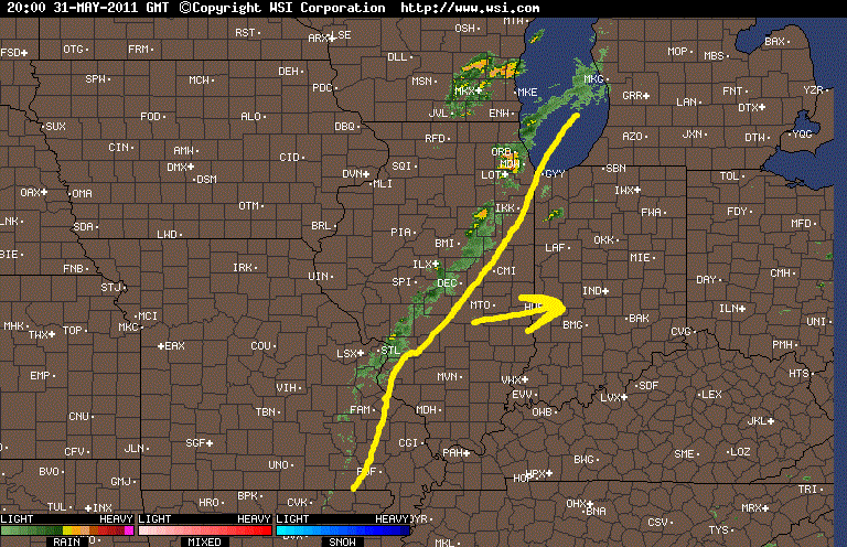
We have a newly issued severe thunderstorm watch in effect for the WLFI viewing area until 9:32pm EDT. Remember in my last post we talked about how there could be a pop up thundershower in the area this afternoon / evening. Well this is what that watch is issued for. Take a look at the radar below. You can see some thundershowers starting to form along that cold front to our west.
We will watch this closely just in case any storms start to become severe. Currently none of these storms to our west are severe warned which is good news! However we are currently unstable enough to support a quick stray strong storm or two within the WLFI viewing area.
Above you can see we are looking at current Lifted Index between -6 and -7 which is rather unstable. Also below we have EHI values around 1 and 2 which would support thunderstorms as well.
So because of this we will continue to watch the data closely overtime along with the radars. If I see any changes I'll be sure to let you know. Also if things get stormy I will be on the Live Chat keeping you posted as well.

Monday, May 30, 2011

A Great Memorial Day Weekend, How Long Will The Heat Last? And What About The Sunny Skies!

That's right, Above is a look at today's satellite. You can see nothing but CLEAR SUNNY SKIES over the area through out the whole day! B-E-A-Utiful outside for sure. A little hot however that didn't stop me from a 2.5 mile run around armstrong pond. 91.4* degrees is what I have recorded as a high in the Lafayette, area. It was 90.7* while I was out on my run. You gotta have FFF, "Faith, Focus, Finish!" You can't let the weather stop you from your goals. :)

And it wasn't just a beautiful day this afternoon but also yesterday for the 100th running of the Indianapolis 500! I recorded a high yesterday of 83.3* degrees and partly cloudy skies across the area. I enjoyed spending time with the family having a cookout while listening to the race on radio.
You can see that your's truly was on grill duty lol. The menu included: Ribs, Hamburgers, Hotdogs, and two kinds of Brats! Beer, and cheese.Yummmmm, And not to forget that Indy Car cake you can find in my older post. That was gone in a matter of a few hours.
We also had a bit of a ping pong competition going on in the garage after the cookout. My uncle and myself started things off with some speed pong. Needless to say we could both have used a bit of practice. lol. Ping pong isn't my sport. I'm a much better Short Stop! ;) It was even better sitting aside watching my sister and aunt go at it. Take a look at the focus on my aunts face.
My sister in the left picture. And my aunt on the right.

I don't think they hit the ball onto the table once! lol. Everywhere else in the garage the ball was bouncing like crazy. So it was very entertaining, I'll give it that! ;)

So the next question is, "How long will these 90s last along with the sunny skies?". Well, I have your answer!
Above is a look at the surface chart for tomorrow morning (Tuesday) around 8:am EDT. Right now it's looking like a day of Mostly sunny skies to Partly cloudy skies across the area. However with that cold front you see off to our west we cannot rule out the slight chance of a few pop up scattered thundershowers within the area. Also we will see a backdoor cold front move through, However it's not gonna cool us any!
You can see in this surface chart above looking at 8:pm EDT that evening, The cold front that is to our west starts getting closer to the area bringing the better chance for a few more pop up scattered thundershowers in the area. This is around a 30% chance. Here's your Tuesday weather break down below.

Quick Cast.....

Tuesday we will look for mostly sunny skies to partly cloudy skies across the area. With a weak cold front moving in from the west we will have to keep in the slight chance of a few pop up hit and miss scattered thundershowers in the area. Expect a high once again in the low 90s around 92* degrees. With a low that night around 65* degrees. It will be breezy with winds between 20 and 25 mph. A few gusts could reach 28 mph possible.

Extended Outlook.
The cold front that will move through the area tomorrow (Tuesday) won't cool us off very much. We will drop to a high on both Wednesday and Thursday in the upper 80s however I see 90s back by this weekend!
~~~~~~~~~~~~~~~~~~~~~~~~~~~~~~
~~~~~~~~~~~~~~~~~~~~~~~~~~~~~~~~~~~~

So the heat is here for a little while! That means you have two options. #1) Get the sun screen out and use it well! Also enjoy the A/C.

Or option #2) Get the swim suite out and soak up the rays, Take the heat in stride and work on that tan! ;) Just do it safely!

Also during this heat please don't leave pets in cars! It get dangerously HOT this time of year. It could kill them in no time. Cars reach temperatures ((well over)) 100* degrees. Always keep fresh cool water for your pets as well as for yourself.

So stay safe and God Bless!
Happy Memorial Day!

Happy Memorial Day.. New Post Up Later On Tonight!

Happy Memorial Day everyone!

I have a new post coming your way tonight talking about yesterday's weather along with pictures from our family cookout. It should be a lot of fun!

Still expect a hot day this afternoon with highs in the low 90s! Remember to thank all who have served this country and are serving on not just today but everyday! God Bless all the men and women.

Have a great day bloggers...

Saturday, May 28, 2011

Your Race Day And Memorial Day Forecast.

I have your Race Day Forecast as well as your Memorial Day forecast all ahead on JIWB! So lets go ahead and get right to it.
Above is a look at your Sunday morning surface chart at around 8:00am EDT. You can see we will be tracking a warm front pushing through the area that will really warm things up, and FAST. I'm looking at highs pushing the low 90s tomorrow as the race gets underway. Here's a little greater detail on the Race Day forecast below.
You can see I'm looking for a high around 87* degrees maybe even the low 90s are possible! I do have a slight 20% chance of a quick brief showers in the morning hours however that is a slight chance and I do not expect it to last all day! I think we will see dry weather for the race and for any cookouts that may be going on in the area. It should turn out to be a nice day weather - wise and otherwise!

If you think Sunday looks hot above, then just wait til you see Mondays forecast! Yes, Memorial Day is looking even hotter.
That's right I'm calling for a high in the low 90s around 93* degrees. With lots of Mostly Sunny skies across the area. This will be perfect weather to honer all the fallen soldiers! Here's the final weather break down in your Quick Cast below.

Quick Cast.....

Sunday (Race Day) we will keep a slight 20% chance of a brief showers in the area during the morning hours however things should clear out nicely during the afternoon hours with partly cloudy skies and a high around 87* degrees. A low that night only dropping to 65* degrees. Winds between 10 and 15 mph gusting between 20 and 25 mph possible.

Monday (Memorial Day) We will look for a hot dry day. Lots of mostly sunny skies across the area with a high around 93* degrees. Expect a low that night around 69* degrees. Winds between 10 and 20 mph with a few gusts to 25 mph possible.
~~~~~~~~~~~~~~~~~~~~~~~~~~~~~~
~~~~~~~~~~~~~~~~~~~~~~~~~~~~~~~~~~~~~

I'm looking forward to spending the day with the family tomorrow enjoying the weather and an awesome cookout as always! Also I made a little something for Race Day, Take a look.
lol, I guess you could say that cake it kind of a specialty of mine! This whole thing is edible. The car is made out of rice crispy treat covered with icing then a layer of fondant. It is all have painted with edible marker. Google Danica Patrick's 2011 Indy car and you'll see it looks pretty close. Not spot on but pretty close.
So a cookout with the family is what I'm doing tomorrow! What about you?

I hope everyone has a great Memorial Day Weekend.
Take care bloggers. And as always God Bless.

Update As Of 5:27pm EDT

As expected the national weather service did in fact issue that severe thunderstorm warning got southern Fountain and south East Montgomery county. This warning is in effect until 6:pm EDT and was issued because of possible quarter sized hail inside the storm!

The rest of the viewing area is looking WET but good. I'm gonna go get a few things done and then I'll be back here later on tonight with a look at your Race Day forecast!

Check Back!