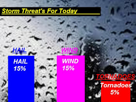
Yes, And I can say that our blogger Brow is on top of things this morning. Yes, take a look at this map I just put together for you all. This is showing our Storm threat risk for today.

You can see that I'M keeping our tornado threat around a 5%chance at this time. Really we are not seeing much wind shear to work with in these storms however our CAPE values are so high around 2,000j/kg and 2,500j/kg and (LI) Lifted Index around -5 to -6 which is the reason I will keep us at a 5% chance for now. Currently tornadoes are not my biggest threat at this time. With CAPE values being this high this also supports some pea to marble sized hail and dangerous frequent lightning..... I think this along with some heavy rainfall at times will be the biggest threats today. Currently I look for this weather to move in closer to this afternoon to this evening. We are not looking at rainfall more then around .25" to .30" Inches however as always we will look for higher amounts in storms.
So we are calling for these scattered thunderstorms to try and form along this cold front. We will look for scattered storms with isolated severe storms possible. Remember we are in that slight risk area for a reason!! And the possibility for a tornado cannot be ruled out just yet even though I think our lightning, few gusty winds in storms, small hail, and heavy rainfall, will be our main threats at this time!!
I will check back here later on as needed. And you know I will be here in storms with more updates!! All we will do for now is keep watching how this storm sets up and be sure to keep your reports coming. If any of you have any storm pictures you would like to send me you can send them to me at storm18mini@aol.com ..........

Looks like some nice little cells moving into Fountain, Warren and Benton Co. Will they hit White Co?
ReplyDeleteWhat do you think the timing will be for the severe weather?
ReplyDeleteNice t-storm just passed through Laf. sun is coming out and it is steamy outside!
ReplyDeleteTeri
Are we in the all clear since this storm passed?
ReplyDeleteI don't think that we are 100% in the clear but it looks like the heaviest may occur south and central Indiana later on today. Still no watches or warnings have been issued.
ReplyDeleteAlso, with that being said...it looks like Laf is now out of the 5% tornado risk area and about 1/2 or less of White county is still in it...Monticello is just under or out of the boundary line of the circle tornado risk area...its all mostly northern Indiana.
With all that info, I am having trouble understanding what is exactly going on. The radar is showing heavy in the south and tornado threat is migrating north.
Maybe Justin and explain?
To the west, it looks like only a few small cells...so my best guess is that there will be some pop-ups that will fall into the WX predictions of us getting t-storms later tonight.
Wow, can you tell that I am bored at work? I just got typing and didn't realize that I wrote a book! lol.
Brow, you do see that a squall line could form? Maybe the tornado risk is down but I wonder about severe t'storms? A watch perhaps?
ReplyDeleteSeems things are getting unstable enough again. And with the clearing we are seeing, its somthing to watch.
What are your thoughts, all is confusing the models are every where
i meant to say Do you see that a squall line could form!
ReplyDelete