I have gone through the latest data and here's what I have come up with at this time.
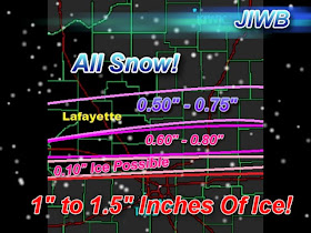
We will see snow showers move into the area later on this evening around 7:pm EST or so. This will be the start of this system. We can expect 2" to 4" inches of snow through out tonight. At this time the major ice event is looking to stay pretty much from I-70 south. However some light ice accumulation may be possible in the southern parts of the viewing area. Here's a map on my thinking of where the sleet and ice will set up over the next few days.

You can see north of Lafayette, staying all snow. Lafayette, and around areas I'm expecting to see sleet accumulations between 0.50" inches and 0.75" Inches. Just south of Lafayette, in northern Montgomery county expected to see slightly higher sleet accumulations. Between 0.60" and 0.80" Inches. And in the southern parts of Montgomery county some light ice accumulations will be possible. I currently have 0.10" inches of ice expected.
Areas south of Montgomery, county could be looking at ice accumulations between and inch and an inch and a half! This will cause down trees across the area along with a huge amount of power outages. This will be VERY dangerous. And I haven't even got to the winds yet!
Here's what my thinking is currently on the final storm total snowfall...

This is counting in what sleet or mixed precipitation could be seen in parts of the viewing area. This will be like blizzard conditions! We are going to see steady winds over the next few days between 15 and 29 mph. With gusts on Tuesday and Wednesday between 35 and 40 mph! Whiteout conditions across the area with snow drifts many feet deep in areas! Again if you can stay home over the next few days or move plans then that would be the best thing you can do until this storm passes!
So right now I'm thinking most of the area will see snow and sleet rather then snow and ice! However some light ice accumulations are possible in the southern parts of the viewing area. This is the data as of now! I will check back again this evening with another update before this thing really gets kicked off!
Take care bloggers. Go ahead and get what you need today! God Bless. I'll check back.
Send you snow pictures and snow total reports to me at dobby1717@aol.com Thank You!

No comments:
Post a Comment