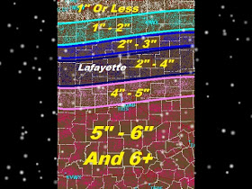
 You can see that a slight shift to the north or to the south will effect snowfall totals BIG TIME!!! This system is just amazing to watch on radar and is even more amazing to track! I like a challenge lol :)
Now the snowfall amounts above are what I'm expecting at this time! However to stay on top of this system I will be right here off and on all night. So that if I notice this system starting to shift I can tweak the amounts whether it be for more or less in the way of snowfall. So check back frequently through out the night for updates! I will be updating as needed!
Now as for wind. Well, that doesn't seem like it will be a threat as the snow is coming down. We will only see winds tonight between 3 and 5 mph once the snow starts to become more wide spread in the area between 4:am and 5:am EST. Also winds between 3 and 5 mph through out the day of Thursday. Winds won't start to pick up a bit until Late Thursday night into Friday where they will be between 10 and 15 mph with possible gusts at times to near 20 mph.
Expect lows tonight around 17* degrees with even colder lows tomorrow night of 1* degree! That's without Wind chill! It could be -15* to -20* degrees below zero with wind chill Thursday night into Friday morning if we do in fact see winds between 10 and 15 mph! Be careful because that means you could get frostbite in 30 Minutes or less!
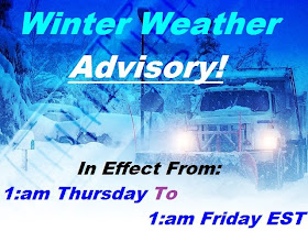
Now we do still have that Winter Weather Advisory in effect for many counties in the area!
 This advisory is in effect as you can see above from 1:am EST Thursday through 1:am EST Friday! Here are the following counties currently in this advisory!
Carroll, Clinton, Tippecanoe, Warren, Fountain, And Montgomery, counties.
So again bloggers. This is the current thinking on this system. But remember a slight shift to the north or south will effect the snowfall totals. So I will do my best to be here off and on through out the night. If I see any changes that need to be noted then I will be sure to post an update!

Thanks Justin. i will be checking in from time to time tonight to see if you see a shift and which direction.
ReplyDeleteGood Work!
Thanks Justin for being there watching out for us. You also never cease to amaze me with your love for the weather and your knowledge and desire for knowledge for such a young man! You truly have a God-given talent. Take care and Lord bless you and stay warm! :-) JLB
ReplyDelete