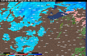
Radar Image Taken At 7:05am EST.....
The thing we will need to watch now will be the winds. Yes, the winds will be between 15 and 20 mph. However later on this afternoon / evening they could try to pick up once again gusting to 30 mph. So blowing and drifting snow is gonna continue to be a threat!
Take a look at this wind information from last night below. This is the wind information for the last ten hours! Some amazing numbers.
LAFAYETTE 35 MPH / 954 PM 47 MPH / 856 PM
INDIANAPOLIS 33 MPH / 229 AM 51 MPH / 227 AM
TERRE HAUTE 31 MPH / 153 AM 44 MPH / 144 AM
MUNCIE 30 MPH / 906 PM 47 MPH / 904 PM
BLOOMINGTON 31 MPH / 127 AM 48 MPH / 1223 AM
INDIANAPOLIS EAGLE CREEK 23 MPH / 453 AM 43 MPH / 214 AM
The thing after the snow is going to be the COLD polar air that will over take the area. I will talk about that in tonight's blog post. Let me just say that nightly lows could be BELOW ZERO! Right now I'm gonna get me a HOT cup of Coffee, and go shovel and measure the snowfall. Stay safe bloggers. I really hope none of you have to head out this morning.
I'll check back with some current storm total snowfall very soon!

No comments:
Post a Comment