Yes, bloggers we do have that wind advisory in effect until 1:am EDT tonight. (Monday). Be sure to bring in any light abjects that the wind may pick up and blow around.
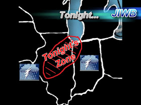
Okay, So we have some thunderstorms to talk about late late tonight into Monday. Mainly Monday morning. These storms we are going to be tracking will start to develop to the northwest however we are not expecting to see them until around 2:am EDT or just after. Our temperatures are currently in the upper 70s and this will help make things unstable as we head into the overnight. So we will need to watch things closely over the next few hours. Take a look at the main impact zone for tonight.
We will be tracking thunderstorms and we will need to watch for some stray strong storms no doubt. However to our northwest is where I expect the strongest for tonight to set up. However we will not let our guard down!
This line of storms will be slightly more developed as it starts to push through our area during the morning hours of Monday. You can see in this image below.
This image is looking at 8:am EDT Monday, This line will continue to get stronger the more it pushes off to our southeast. As the daytime temperatures warm up and make things unstable to our east this line will become even more dangerous as it heads into states such as Ohio, Kentucky, And farther east!
You can see the main impact zone in this map above as well. These main impact zones are where I expect the best chance of tornado development during these storms!
So here's the break down for our area for tonight into Monday, (Tomorrow)...
We are looking for LI (Lifted Index) to be around -3 to -4 which is unstable. Anything around -4 and lower is the potential for severe development. We are also looking at EHI values to be around 2.2 and 3.0. Which also supports moderate to strong storms. And CAPE values around 1.500J/kg to 2.000J/kg which would support thunderstorms and some possible small hail and very frequent lighting! So the main threats for our area over late tonight into tomorrow will be.
Heavy Rainfall around 0.75" to 1" inch expect higher amounts in thunderstorms!
Frequent Dangerous Lightning.
Hail is a threat in some of the stronger cells.
High gusty winds! Winds will gust outside of thunderstorms tonight to 35 near 40 mph and could gust even higher in / During the thunderstorms!
And an isolated tornado in the viewing area cannot be ruled out. However again as I said above I do expect most of the tornado activity to be in or around those main impact zones. Still we will keep a close eye on things!
~~~~~~~~~~~~~~~~~~~~~~~~~~~
~~~~~~~~~~~~~~~~~~~~~~~~~~~~~~~~~
~~~~~~~~~~~~~~~~~~~~~~~~~~~~~~~~~
So what you can do to be storm ready is! Get a weather radio! Stay alert! And stay tuned to your local weather station during storms!
I will be back here off and on through out the night with updates! It's gonna be a long night bloggers. I look forward to tracking with you all!


Dang that main zone looks awedully close to home. :(
ReplyDelete