Hey bloggers. First off I wanted to go ahead and point out that I did change the Live chat a bit. It is no longer a pop up page. This is because I had to switch to a different live chat server. One that was better for everyone. This way we will no longer have to worry about spaming on the live weather chats! I have had a bit of a spaming problem here on the blog lately so this should help out in the long run. I hope everyone is okay with it! Everyone can still feel free to come here and chat live about any weather event that is going on in your area. I will be on the live chats as needed during severe weather events. But feel free to talk with other weather bloggers anytime! :)
Now back to the weather. What your looking at in this map above is all the light blue colors! This is nothing but Flood warnings all across the area. And they're in effect for good reason. After all the rain we seen during the storms yesterday and the scattered showers / thundershowers we seen earlier this afternoon, we picked up well over three inches of rainfall!
You can click this image above to enlarge. Above is a look at where the Wabash river currently stands and where it is expected to crest by tomorrow morning. Currently the Wabash river is sitting at 17.9ft. It is expected to crest tomorrow morning at around 8:am EDT at a high 19.9ft. This will be a good 8.9ft above flood stage! If you live by the rivers or know anyone who does please take note of this and stay weather ready! Never drive through flooded roads. Remember the saying "Turn around don't drown".
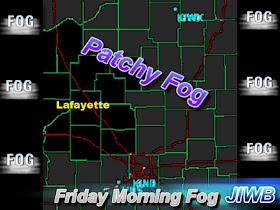
The other thing we will be watching tomorrow morning other then the rivers will be the chance for some patchy fog in the area.
With temperatures and dew points being only a degree or two apart at this time Fog becomes a real possibility! So just allow a little extra time to get where you need to be as you head out in the morning. Better to be safe then sorry!
Otherwise tomorrow we will look for partly cloudy skies with cooler highs in the area as that cold front continues to push off to our east. I'm looking for a high tomorrow in the upper 60s / low 70s. Models are showing highs right around 69* degrees. Winds light between 3 and 5 mph.
Also for the warm weather lovers I'm looking for highs pushing the low 90s by as soon as Race Day! Yes, a hot hot Sunday is looking to be forecast. I will try to keep you posted on that as well.
That's it for now. Take care and God Bless!


No comments:
Post a Comment