We're tracking another strong cold front to push through the area tonight into tomorrow (Friday). It will again give way to a line of showers / thundershowers across the area. Take a look at this prog chart below.
This is looking into later tonight / early Friday morning. You can see that cold front pushing across the area with the rain forming along the front. Right now I'm looking for rainfall between a tenth and a quarter inch with slightly higher amounts in any thunderstorms.
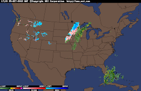
Here is a look at the radar image taken at 1:40pm EDT below.
You can already see that line of rain developing on radar. The warm air out in front of this system and the much colder air behind it. Take a look at the snow falling in that colder air just behind the front.
this colder air is what will move into our area as we head into tonight / Friday. Its going to stick around for awhile. Here's a look at your detailed forecast below.
TONIGHT- we will look for cloudy skies across the area with that line of showers / thundershowers moving into the area as we head through the evening. Expect a low tonight around 42* degrees with winds between 10 and 15 mph gusting to 20 - 28 mph.
FRIDAY- we will start out with a few left over showers / thundershowers possible. However skies will begin to clear out becoming partly cloudy as the day goes on. A high around 52* degrees with a low Friday night around 33* degrees. Winds light between 10 and 15 mph.
SATURDAY- we will see mostly sunny skies across the area with a cool high around 52* degrees. winds light and a much cooler low around freezing at 32* degrees.
EXTENDED OUTLOOK- Monday through Thursday we will see highs in the 40s! With lows in the lower 30s and upper 20s. Its gonna be chilly! Wednesday (Halloween) is looking good weather - wise. A little chilly with a high around 47* degrees and a low that night as the trick or treaters head out of 30* degrees.
Right now the NAO and AO models are showing another slight warm up before any real hard core cold sets in. You can see the dip in the NAO model below showing the cool down for this week into the first of November. However it's trying to go neutral again as we head into that first week of November.
Here is how the AO model is looking below.
Both showing that spike in temperatures into the first week of November. So cold weather lovers don't get your hopes up yet. This cold burst isn't gonna last to long. We will continue to look ahead and see when we can find a good hard core cold trend set in place.
That's it for now bloggers. Have a great day and God Bless!


No comments:
Post a Comment