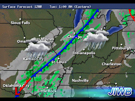
Above is a look at what we're tracking tonight and into Tuesday. This line of rain showers forming along a cold front will make its way through the area during the overnight hours. Along with the rain, the cold front will help us get our high temperatures closer to the average for this time of year. Its been crazy, our average high for this time of year is around 35* degrees. We have been a good 20 to 30 degrees above our average over the past few days. Once this cold front moves through the area we will see highs fall back into the 40s and 50s however this will still be a good 15 to 20 degrees above where we're suppose to be. Average low for this time of year is 20* degrees. So we have some work to do. I'm still looking for that harsh snap back to normal from nature as we head into the second week of this month.
I'll talk more about that here in just a second. First off lets break down the forecast for tonight.
You're looking at a surface chart for 1:am EST Tuesday. You can see that line of rain showers moving closer as well as the cold front. Right now I'm expecting rainfall sometime after 1:am. A low tonight around 53* degrees with winds between 15 and 20 mph. Gusts to 25 and 30 mph possible.
The rain showers will linger into the day hours of Tuesday before tapering off. This is a surface chart looking into Tuesday around 1:pm EST. As we head into the late afternoon and evening hours we will see the skies start to clear out a bit becoming partly cloudy to mostly clear during the overnight. A high Tuesday around 57* degrees with a low that night around 34* degrees. Winds will be between 10 and 15 mph gusting to 20 mph at times.
Now for that system I have been watching for the second week of December.
Here is a look at one of my weather models showing this system developing to our southwest on December 10th. I've been watching this system closely because of this strong low pressure system giving way to heavy precipitation in many areas of its path. whether it be in the form of rain or snow. This will be one to watch!
Here is another model image looking into the 11th. That colder air starts getting wrapped into this system putting us on the colder side with snow potential. After this system lifts to our northeast we will really see that cold air filter in getting our highs and lows back around where they should be for this time of year. With that said, its looking like an active weather pattern for the month of December!
This is something to watch. I will keep you posted. Have a great day bloggers.


No comments:
Post a Comment