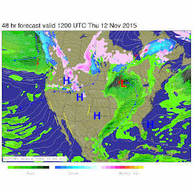
Rain is on the way bloggers. Rain and wind! Right now I'm watching a low pressure system out to our west that will be moving our way giving way to very windy conditions across the area as well as some rain / thunderstorms possible.
Above is a look at just one of the surface charts showing this low pressure system to our west. This system will continue to develop over the next 24 to 48 hours. We will look for rain / thunderstorms to start affecting us by tomorrow (Wednesday) night into early Thursday.
Here is another look at this surface chart as we move into Wednesday night.
I expect anything severe to stay well to the west of the state in areas of IL and MO. What we will see will be much less intense.
Take a look at the storm threat map below
Main threats for our area during this event will be high winds. We will see the winds pick up Wednesday night between 15 and 20 mph gusting over 30 mph. Winds will continue to grow stronger as that low pressure moves through the area with tightly pack isobars as we head into Thursday. Thursday winds will be between 20 and 25 mph gusting between 35 and 40 + mph.
Things will be cooler as we head into Friday once that cold front finishes passing through the area. Highs not even reaching 50* degrees and low falling into the upper 20s. Here is a look at your 5 day forecast below.


polo lacoste, michael kors outlet online, nike air max uk, replica handbags, nike roshe run uk, uggs outlet, coach outlet, michael kors outlet online, sac vanessa bruno, oakley pas cher, ray ban pas cher, nike air max uk, lululemon canada, new balance, nike free uk, north face, nike air force, hogan outlet, kate spade, burberry outlet, mulberry uk, coach purses, true religion jeans, michael kors outlet online, abercrombie and fitch uk, michael kors outlet, hollister uk, converse pas cher, nike blazer pas cher, timberland pas cher, nike tn, true religion outlet, ralph lauren uk, michael kors, guess pas cher, sac hermes, michael kors outlet, ray ban uk, uggs outlet, michael kors outlet online, true religion outlet, coach outlet store online, michael kors, vans pas cher, true religion outlet, hollister pas cher, nike air max, michael kors outlet, north face uk
ReplyDeleteconverse outlet, chi flat iron, ray ban, insanity workout, ferragamo shoes, mac cosmetics, herve leger, soccer jerseys, converse, louboutin, north face outlet, asics running shoes, jimmy choo outlet, gucci, ralph lauren, mont blanc pens, soccer shoes, celine handbags, nike trainers uk, beats by dre, vans, bottega veneta, babyliss, nike roshe run, hollister, ghd hair, wedding dresses, giuseppe zanotti outlet, abercrombie and fitch, hermes belt, nike air max, hollister clothing, iphone cases, north face outlet, vans outlet, nfl jerseys, hollister, mcm handbags, valentino shoes, p90x workout, new balance shoes, nike huaraches, timberland boots, instyler, lululemon, nike air max, longchamp uk, baseball bats, reebok outlet, oakley
ReplyDeletecanada goose outlet, canada goose jackets, pandora charms, moncler uk, moncler, barbour uk, moncler outlet, pandora uk, moncler, louis vuitton, juicy couture outlet, canada goose, canada goose, juicy couture outlet, pandora jewelry, canada goose outlet, louis vuitton, links of london, supra shoes, canada goose uk, moncler, ugg, toms shoes, ugg,ugg australia,ugg italia, canada goose, canada goose outlet, coach outlet, swarovski crystal, wedding dresses, pandora jewelry, barbour, louis vuitton, moncler, lancel, doudoune moncler, ugg pas cher, ugg,uggs,uggs canada, karen millen uk, marc jacobs, louis vuitton, ugg uk, louis vuitton, moncler outlet, replica watches, swarovski, hollister, thomas sabo, montre pas cher
ReplyDelete