Friday, April 30, 2010

Watching The Line!

Ok, I have gone through the latest data once again and I think I'm ready to let you all in on what we have in store for us weather - wise this weekend! As you already know we have a good size line of storms that has developed along side a strong cold front to our west. This line is what will move into our area by later on tonight closer to 2:am and 3:am give or take a little. You can see the line in this radar image just taken a little bit ago below.
Now currently we are not in the severe weather risk area however it is still very close. Also right now we are rather stable. With Lifted index at +2.5. This is good however models show that this LI number could drop between -1 and -5 by tomorrow AKA Saturday. This would be unstable enough to spark a few strong storms. However with this way things look right now I'm going to keep us in the Scattered to Moderate thunderstorm range. This meaning Scattered thunderstorms however a few stray strong storms cannot be ruled out! Now rainfall will also be something to take note of. As between Saturday and Sunday we could end up with between 1" and 2" inches grand total in many areas.

For now will will continue to watch this developing line and if anything is to change I will be sure to pop in and let you know!

Stay tuned and stay safe! ;)

Developing Story!

I will be here ready to track this next system about to move in over the weekend with you all. I'm about to go through some weather data right now and then I will be back with an update.

So stay tuned and stay storm ready!

I'll check back.....

Saturday, April 24, 2010

Strong Storms To The South! 44 Tornadoes & Counting!!

I just checked the latest Bufket weather models and they are telling me that our lifted index has become even more stable then before. They currently stand at +2.7 which is pretty good! Because we had so much cloud cover today we stayed pretty stable. Thank you clouds! :)

Now we are not done yet. We do still have more heavy rain at times on the way through out tonight into tomorrow. Take a look at this radar image taken at 6:58pm EST below.
You can see whats going through right now and then whats still to come. Currently it is looking like we will have a slight break in the rain before the next batch pushes through tonight into tomorrow. Now right now I'm not looking for anything severe with this next batch in our area. Now areas to our south has really had some strong weather to deal with this evening. I have already seen 44 tornadoes reported with this severe weather outbreak today. And some of them worse then others! Take a look at this below...

1 W DURANT, HOLMES, MS.

*** 1 INJ *** MULITPLE CARS BLOWN OFF INTERSTATE 55. UNKNOWN NUMBER OF INJURIES. REPORT RELAYED VIA ATTALA COUNTY EMA.
~~~~~~~~~~~~~~~~~~~~~~~~~~~~~~

EBENEZER, HOLMES, MS.

*** 1 FATAL *** NUMEROUS HOMES SUSTAINED STRUCTURAL DAMAGE. WIDESPREAD TREE DAMAGE. UPDATE...MEMA CONFIRMING 1 FATALITY IN HOLMES COUNTY. (JAN)
~~~~~~~~~~~~~~~~~~~~~~~~~~~~~~

2 N FRENCH CAMP, CHOCTAW, MS.

*** 3 FATAL *** EMERGENCY MANAGER REPORTS EXTENSIVE DAMAGE IN THE COUNTY. UPDATE...MEMA CONFIRMS 3 FATALITIES IN CHOCTAW COUNTY.
~~~~~~~~~~~~~~~~~~~~~~~~~~~~~~~

Be sure to pray for these people!! God bless!! We are lucky on this system. But still more rain / thundershowers on the way.....

I'll check back again if needed.....

Update!

Oak, bloggers here we go! ;) After looking through the latest data this big mess of a system is a BIG heavy storm maker! But the good news for us is we have been pretty stable in our area for the last few hours. Our current lifted index is at +1.0 which is ok. So right now as the storms are moving into our area they are starting to weaken a bit. Not major weakening or anything! But enough. Now we have very high CAPE values and EHI values to our south! This is where they will have some tornado outbreaks. And this is where the National weather service has already put tornado watches into effect. Now yes, we will still continue to watch this system closely just in case something is to change and become a bigger threat! Otherwise here's what we have to watch out for this evening.

Heavy rain at times in storms.

Few gusty winds in storms.

Lightning as always with any storm.

Tornadoes are at around a 5% chance and higher the more south you go. Pretty much from Indianapolis south!
~~~~~~~~~~~~~~~~~~~~~~~~~~~~~~~~~

So scattered to moderate storms this evening. I will not totally rule out a stray strong storm or two as we are under a slight risk for severe! However this is how things look at this time.

I will continue to watch and if anything changes I will be back to let you know!

Stay Tuned.....
Going through the latest as I type. I will check back with a update!


STAY TUNED!

Wednesday, April 7, 2010

Storm Talk!

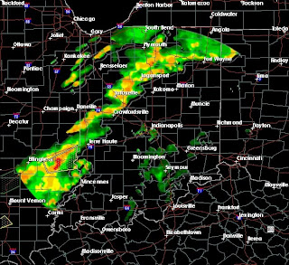
Well, this has been a HUGE Line of storms that's for sure! But first off I just want to say THANK YOU to all my bloggers for the big welcome back! :) Sorry for all the lack of updates but I have been busy lately trying to focus more on my running with 5K's coming up soon. However you can rest easy knowing that even if I don't update everyday I will try my best to be here on days like today! If the weather calls then I'll have the updates posted right here on JIWB.

Now take a look at this national radar image taken at 9:34pm EST tonight.
You can see this huge line of storms that part the states into two halfs. Also you can see the main severe stuff really stayed to the southwest of the WLFI viewing area as forecasted. Finally a system went as expected lol :) Now the WLFI viewing area did see some gusty winds at times, Along with some Pea Sized hail in areas and LOTS of heavy rainfall! I recorded .60" inches of rainfall here in Lafayette. Now the good news is we only had one storm report in Indiana with these storms and it was in southern Indiana.

HAIL REPORT
SIZE 1,00"
CLAY CITY, CLAY IN
~~~~~~~~~~~~~~~~~~~~~~~~~~~~~~~~~~~

I'm very glad to say that this was the only severe storm report in Indiana (At this time). I had been watching the data all day to see just how unstable we would get before the storms really moved in, And the good news is we didn't see much if any sunlight earlier this afternoon. So this really kept things pretty much in check. Our Lifted Index did fall to around -1 which is slightly unstable but not to bad. Things really can get messy when it fall between -3 and lower! Also our CAPE values and EHI stayed rather good as well. EHI only made it to around 1 which isn't bad. You usually want it around 1 to 2 for severe weather development. Now had we see sunny skies earlier this afternoon then we would have been tracking much more dangerous weather then what we have already seen tonight. So be thankful as always! Areas to our Southwest seen some tornado warnings put into effect but I have not seen any tornadoes reported which is good new.

So as for now you can see in this radar image below that things are pretty much passed most of the WLFI viewing area at this time. Radar Image Taken At 9:34pm EST...
Some counties will still be seeing rainfall into the over night hours but things should start to look better as we start our day tomorrow. So for tonight just some scattered showers / thundershowers. All tornado watches and severe thunderstorm warnings have been allowed to expire in the WLFI viewing area.

Now as for tomorrow I think we will keep some sun in the forecast possible. However as this cold front that fired up these storms moves through it will cool us off pretty good as I only look for highs tomorrow to be in the low to middle 50s. However by Friday we will be back in the low 60s with 70s returning by this weekend! We will be back to the dry and warm weather in no time. :) So thanks again and I will be back next weather event!

You Can Count On It! ;)

Looking Good!

The severe thunderstorm warning has been canceled for Fountain county and Montgomery county as of now! This line of storms is moving to the north north east and just about out of Tippecanoe county. You can see the latest radar image below. Taken at 6:30pm EST.We are still watching things closely but things are looking better!

Still stay tuned as I will be back with another update here soon.....

Still Looking Good...

We still have the severe thunderstorm warning in effect for southern fountain county and Western Montgomery however the good news is I have not seen any rotation with this cell. And Echo tops (Cloud Tops) Are only around 30,000Ft. Which is not to bad. Storms become really severe once the Echo tops usually reach around 40,000ft to 45,00ft.

Otherwise the rest of the WLFI viewing area is just seeing moderate thunderstorms with heavy rainfall at times and a few gusty winds! We are still doing good with the strongest staying to our southwest! Still for now our main threats are the Heavy rainfall falling at 1" to 2" inches an hour with pea sized hail possible. Also gusty winds! and Lightning as always!

Stay Tuned.....

Thunderstorm Warning.

Severe thunderstorm warning in effect for Western Montgomery county, and Southern Fountain county. This cell is moving North North East and has Heavy rainfall falling at a rate of 1" to 2" inches an hour with pea sized hail possible.

Line getting closer...

We have a few warned cells to our north moving north north east. The line is getting closer as you can see in this radar image below. Right now this line is packing heavy rainfall falling at a rate of a half inch an hour to as high as 1" to 2" inches an hour in areas. Also some small pea sized hail could also be possible. This is just the outer edge of this line. The main stuff will be more detailed closer to 7:00pm or so. Still the strongest is staying to our south west like expected. Which is good news for us! I'm still watching things closely and I will keep you posted as needed. For now just moderate to heavy rainfall and some scattered thunder. Stay Tuned!
I'll check back again as needed.....

Line Of Storms...

We have this developing line of thunderstorms that will move through the WLFI viewing area by later tonight sometime between now and 7:00pm give or take. There are some warned cells inside this line as you can see below. What we can expect is some strong winds, Heavy rainfall, Lightning is a threat with any storm, And some possible small hail in areas.
Radar Taken At 5:00pm EST.....
Right now I'm keeping the tornado threat at around 5%. Models are pointing to the really heavy stuff to stay to our south and west at this time. However a stray strong storm or two cannot be ruled out. Otherwise most of us in the WLFI viewing area should see Scattered to Moderate thunderstorms overtake the area tonight. We do have a tornado watch in effect until 8:00pm tonight EST for the whole WLFI viewing area.


I'll check back as needed.....