Sunday, August 31, 2014

Labor Day Forecast. Storms Are On The Rise!

Thunderstorms are still the forecast as we head into Labor Day and into Tuesday. you'll have to be careful if you're going to be out grilling.
As you can see above the SPC is still expecting some severe weather likely as we head into our holiday. I agree with this! We have a strong cold front that is going to be pushing through the area giving way to scattered thunderstorms tomorrow morning / afternoon becoming more of a line of storms later that evening into early Tuesday.
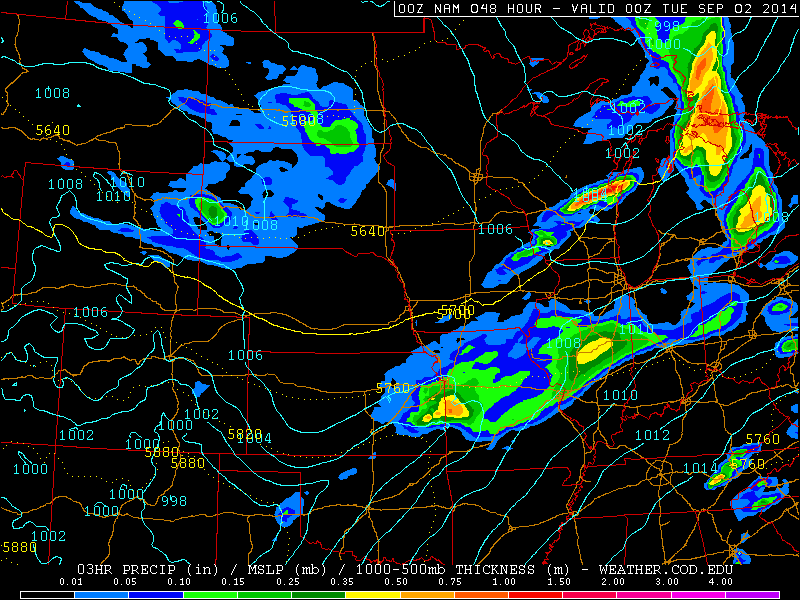
Above is a look at around 8:pm EDT Monday. More wide coverage of rain / thunderstorms start to take over the area. Heavy rains move in with frequent thunder.

Below is a look at around 5:am EDT Tuesday. You can see much much heavier rainfall in this image moving through the area. We could easily see rainfall Monday into Tuesday between 1.00" inches and 1.50" Inches. With locally higher amounts in thunderstorms. Some areas could see closer to 2" Inches! Get the inner tubes out and ready to go bloggers.

So what will our main threats be? Take a look below.

Right now I'm expecting High gusty winds in storms! Heavy heavy rainfall. Total rainfall could be around 2" Inches. Small hail is likely with higher CAPE and EHI values. And frequent lightning. Right now tornadoes are not looking like a top threat at this time. However with that said we will not totally rule it out at this time. I will continue to keep you posted as needed bloggers. Hope all are having a great weekend!

Take care and God Bless!

Update On Your Labor Day Forecast

I'm back with an update on your Labor Day forecast. Currently looking like Monday (Labor Day) we'll have rain / thunderstorm chances! Especially Monday evening / into Tuesday.

I have been going through weather data tonight and currently I'm seeing EHI values Monday evening into Tuesday currently expected to be between 1 and 2 which is fairly unstable. This means we would be unstable enough to support thunderstorms along with some strong to severe thunderstorms. CAPE Values are currently expected to be between 2,500 j/kg to 3,000 j/kg which would support small to medium sized hail and frequent lightning!

Take a look at this map below.
This map is looking at around 8:pm EDT Monday night. You can see scattered showers / thunderstorms are starting to move across the area. Things start to fill in a bit more as the night goes on.

Taking a look into around 5:am EDT Tuesday below you can see heavy rains across the area along with thundershowers.

The storm prediction center also is expecting severe weather for our area Monday as you can see below.

So what would our main threats be heading into Monday evening / early Tuesday? Well, as of now with EHI values around 1 and 2, I'm looking for a few strong thunderstorms likely. 

Heavy rain during storms, We could see anywhere between 1.00" and 1.5" Inches of rainfall between Monday and Tuesday. And with higher CAPE values we can expect frequent lighting along with small hail / gusty winds. 

I will try to have another post on your Labor Day forecast soon. Take care bloggers, God Bless!

Friday, August 29, 2014

Labor Day Weekend Forecast! Might have to dodge the rain drops!

Labor Day is coming up. The weekend is near. Here's a quick peak into the weekend and what we can expect weather- wise.
That's right, We have a chance of showers / thunderstorms pretty much everyday unfortunately. Saturday It's looking like we have around a 60% chance of some thunderstorms across the area. Not looking severe at this time as well as the SPC hasn't issued a severe weather risk at this time. however with that said a stray strong storm or two cannot totally be ruled out. LI index is expected to be between -3 and -6  however the unstable EHI is currently setting up more to our west in IL, areas. Still we will watch this! High Saturday around 85* degrees with a low around 68*.

Sunday looking partly cloudy through out most of the day, Pretty dry however the slight chance of a stray pop up shower isn't out of the question. High around 86* and a low that night around 70* degrees.

And Labor day. Scattered thundershowers off and on through out the day. Hopefully you all can dodge the rain drops and get your grills going lol. A mild high around 85* degrees with a low that night around 69* degrees.

I will try to fine tune this forecast we the days go on bloggers. Take care and have a great weekend!

God Bless!

Sunday, August 24, 2014

2014 - 2015 Winter Outlook. El-Nino? Or Folklore Forecasting?

Well bloggers, After looking into what this winter could bring some of you may be pleased while others not so much. after doing a lot of searching and looking through data there are a lot of signs pointing to a weak / moderate El-Nino winter. This could mean a big difference in the temperatures and amount of precipitation we see this winter in comparison to how things were last year.

So what is El-nino? Well, to make a long story short, It's basically warming of the sea surface temperatures across the central and east central pacific. This effect's our jet stream patterns which of course will effect how mild or wet our season's are, especially as we head into the approaching winter months. Take a look at these images below showing how El-Nino and La-Nina effect our jet stream patterns.
Above is a look at how an average jet stream pattern usually sets up in both the summer months (Orange line) and the winter months (Blue line). You can see that usually in the winter we would see that deep dip in the jet stream giving way to a lot of cold polar air and setting up the storm track closer to home giving way to more moisture and or snow events. This is not he case with an El-Nino. Take a look.
Above is the El-Nino pattern. You can see how the warming sea temperatures effect the jet stream. A split develops pushing that colder polar air more north giving was to a more mild winter as well as drier for much of the midwest.
With La-Nina which we have had in the past there are much colder sea temperatures! Which means less of a temperature difference between the sea temps and the air temp. Giving way for a single weaker jet stream and allowing more polar air to dip into the midwest and also pulling in more moisture giving way to more storms! But again this will not be the case this winter season.
So what will be the case? Well, take a look above. This is a map with what a typical El-Nino winter looks like. Those split flow jet streams with milder temperatures over the midwest along with less snowfall. Frigid air stays mostly north with wet weather in the south and around the west coast. Yes, not what all my snow lovers are wanting to hear, I know! I'm right there with you! A lot of people will be upset at me for saying this lol but I would love a repeat of last winter!! The 2nd snowiest winter on record for the greater Lafayette, area.

So what can we expect winter- wise this season? well, it's looking like we will experience a more mild winter. Equal days of both above and slightly below average temperatures. Below average precipitation likely.
You can see above that our average high for the month of November, is right around 50* degrees, average monthly high for December is around 35* degrees, and average monthly high for January is around 31* degrees. This is what I expect things to look like during our winter. (Close to average). Not saying we won't see a brief cold spell every now and then as that is likely. However for the most part we will see milder temps and less precipitation.

Speaking of precipitation!
Last winter we saw a total of 64.4" inches of snowfall in the Lafayette, Indiana area. On average we only see a yearly total of around 26.2" Inches! That's 38.2" inches above our average snowfall! Outstanding!! So yes! This winter following the crazy one last year will seem like a big big change!

Now if you don't like this forecast and you just know in your gut that this winter will be another outstanding winter! Then please by all means find your data and share it with us! I myself am going to put some weather folklore to the test and see if nature can out forecast science. I will always hold on to that little bit of hope that my forecast is wrong and we see an abundant amount of snow!! lol So help me out bloggers! here are a few weather folklore forecasting tools below. Take them and try them out for yourself, Please come back here or to our Facebook page and share your results with us! I'd love to see what you all find out.

Take care everyone! Thanks for taking the time to read the weather blog.

Weather Folklore, Signs Of A Cold Snowy Winter!

* Very thick onion skins or corn husks
* Woodpeckers sharing a tree
* Early arrival of crickets on the hearth
* Spiders spinning larger than usual webs
* Lots of acorns
* A small rust/orange band on a wooly worm caterpillar
* Trees are laden with green leaves late in the fall.
* Hickory nuts having heavy shells.
* Tree bark is heaviest on the north side of the tree.
* Crickets are in the chimney.
* Hoot owls call late into the fall.
* Raccoons have thick tails and bright bands
* Squirrels gathering nuts early in the year
* Pigs gathering sticks
* Frequent halos/rings around the sun or moon
- Heavy and numerous fogs in August

Saturday, August 23, 2014

Enough Hot And Muggy! Looking ahead for Autumn Equinox!

We are back bloggers! It has been a crazy summer, and now I'm ready to get back on the weather blog. We have had a lot of rain and storms this past week which has made my anxious to get back in the hot seat.

A blistering summer has been the theme this year with high humidity levels and temperatures in the 90s! Well bloggers, more of that is on the way sadly. I know a lot of you love this hot weather however the air has been thick with humidity recently, and that I don't think many like to much.

I'm looking for high the rest of this week into the weekend in the 80s and 90s! The high for Monday alone to start our week is expected to be in the lower 90s around 92* degrees! We will see heat index values easily over 100* degrees! You walk out the door and the moisture in the air hits you like a brick wall. I don't know about you all but I'm ready to give my A/C a rest and start opening windows :) With that said I have already been looking ahead for Autumn! And believe it or not, Autumn is closer then you may think.
Yes, Autumn equinox is September 22nd at 10:29PM EDT exactly! But the question is "Will the temperatures follow?" Hard to say at this time. Right now we're looking to be steady in the 80s at least through next week. Hopefully I'll have your answer on that soon. I will also (As I do every year) try to give you all a sneak peak into your winter forecast before long. Hard to believe that it's almost that time of year again when we start wondering what winter will be like. On that note, Christmas is only a little over 3 months away..... lol WOW it is coming fast! :)

For now though lets just focus on now. Let's take a look at what we can expect weather - wise tomorrow.
Sunday we can look for partly cloudy skies through out the day, however a stray shower / thundershower cannot completely be ruled out. Chance of rain around 30% at this time. Look for a high around 87* degrees with light winds between 3 and 5 mph, Occasional gust to 10 and 15 mph. Look for partly cloudy to mostly clear skies Sunday night with a low around 69* degrees. winds light between 3 and 5 mph.

I'll be checking back soon.