We woke up to nothing in our rain gauges! We missed out this time around but were did the rain go? Well we in Tippecanoe county got a big NOTHING! But if you go up just a bit to white county they got near a quarter of an inch with reports of .23" of an inch. If you go up a bit more to Jasper county there were reports from a trace to .19" of an inch. Not much all around which Jasper county don't need anymore rain! So with all this talk of rain when is our next chance of seeing any? Well tomorrow there is about a 30% chance of rain in the morning and that will be light and takeing a chance!. We will have to wait and see as it comes in.
If any of you would like to learn more about weather you can check out my web site just click on this link!
123 Weather Home Page.
All have a great day enjoy the nice Fall like weather and watch out for the gusty winds we will have through out most of the day..........

Tuesday, September 30, 2008
Monday, September 29, 2008
Where did the rain go? And get ready to pull out the JACKETS!
Well rain was in the forecast and some northern counties did see some I'll have there rainfall amounts posted on here later tomorrow and some places south of us are going to see some rain! but what about us? Well earlier this afternoon there was rain moving into mid I'LL, and started to evaporate before it reached us as our humidly started to drop making our air to dry for any rain to reach the ground. So this just gos to show you can't get all the forecasts right as much as I would like to! :( But we have to remember nature will do what it wants to! and she will change and she can do it fast. That is what went on today. I was watching the maps and radars all day and every time I looked there was something new and or something changed. But I'M still looking for more Fall like temps this week as of now really! Our current temp is 66.4* and I'M looking for a high tomorrow of only 60* so remember to take you jackets as you head out the door for work and school in the morning it will be a chilly one!! Cold weather lovers get READY TO RUMBLE!!!!! LOL! We are still getting some good wind gusts I know this because almost all our Halloween stuff is blown over! They should start to calm down later tonight! So again I'M not looking for our next chance of rain till Wednesday Let's get it right this time!!!!! LOL :) So you all can rest well................ Oh wait!! We will cool of to around a high of around 58* on Wednesday as a 2nd cold front will move through later tomorrow. So the big deal is don't forget the JACKETS!! Enjoy your evening.....
Where's the rain?
The latest update.
The timing has changed as well as the rainfall amounts! We are now expected to see rainfall amounts anywhere between a tenth and a quarter of an inch. This is because our current humidity is now at 52% and falling so that means our air is getting dry which means some of the rain has evaporated. Still a lot of stations are still giving us a 60% to 80% chance and by the current looks of my maps it is looking that way still we will keep watch and if it changes again I will let you know.
The timing has changed as well as the rainfall amounts! We are now expected to see rainfall amounts anywhere between a tenth and a quarter of an inch. This is because our current humidity is now at 52% and falling so that means our air is getting dry which means some of the rain has evaporated. Still a lot of stations are still giving us a 60% to 80% chance and by the current looks of my maps it is looking that way still we will keep watch and if it changes again I will let you know.
Sunday, September 28, 2008
Some rain and cool temps is on the way.

That's right a cold front is the big story this week! this is what will help get us into more Fall like temps!. And maybe a little needed rain today / (Monday) Now I am not expecting any Strong or severe thunderstorms just some rain showers is all! The total rainfall amount ecpected after all the rain is said and done is around three quaters of an inch. This is expected to start around 1pm this afternoon and go through maybe 7pm this evening. Then another cold front will fallow that one and with it I'M not even going to say rain it would only be a 20% to 30% chance! However it will also help to cool us down to a high temp of maybe around 58* to 60* by Wednesday! Now that sounds like Fall to me!!!!! :-)
So a few showers tomorrow / (Monday) and after that another great week were hopefully we won't need the AC on how cool would that be! Get it (Cool) I know I know that was bad! :-) LOL!
So get out this week and enjoy the Fall weather.....
I'll check back soon..... As needed..... :-)
Saturday, September 27, 2008
Back from the Feast!
Back from the Feast of the hunters moon and a good day it was! there was some really great jugglers there great food and family! The weather was great as well and it's not over yet there is still tomorrow to go!!!!! If you did not make it out there today then you might want to go tomorrow the food is a good reason to go LOL..... :) Here is a picture of the jugglers below they were good!!
They were balancing on that wood you see and was juggling sticks lit on fire! you can't see the fire to well in the picture but it is there KIDS DON'T TRY THAT AT HOME!!!!! :-) REALLY! It was a great day I for one love the Buffalo burgers YUM :-) lol! They are the best in my book! all the food is good. The Feast opens tomorrow at 9:00am and let me tell you if you want to miss traffic then you might want to get there early! We pulled out later that afternoon and it was lined WOW was it lined! But it was fun!
Everyone have a great day and a great time at the Feast! :-) Enjoy your weekend..........
Friday, September 26, 2008
The Feast is looking good and Fall is on the way.
It is great to check in with you all! :)
Has this weather been great or has it been great! I don't know about you all but I'M ready for some fall like weather!!!!! By the looks of thing's it won't be much longer!
Not only that but the Feast starts tomorrow and it is looking great and dry for once the feast is dry WOW I know that don't happen to much LOL..... So when will the cooler weather start to push through? Well we have a cold front which will start to make it's way through our area by Monday! and that will cool us off a bit! As temp's will drop from the low 80s as they have been all week to the mid to low 70s! And not only that but how about our nightly lows? They will fall as well to around the mid to upper 40s how dose that sound? :) for all you cold weather lovers. So the Feast of the hunters moon, is looking good and our next chance for any rain is going to be when the cold front moves through on Monday late evening and as you know this could still change and by that I mean the timing! So I will keep you updated on that and what we could expect. As of now were are not expecting anything severe but you never know when it comes to Indiana! :-) We will be going to the Feast so I will try to post some pictures when I get back for all you! Everyone go and enjoy the Nice weather who knows next year it could be wet!!! but let's not worry about that this year! lol.....
Oh One more thing! Another old way to help tell how the winter forecast will be is squirrels!!
If you all remember last year the squirrels were all over the place and there were so many! running wild! and we had above normal snowfall! Well this year the squirrels are just as bad doing the same thing! So we will just have to see how thing's turn out not to forget the cold air is still building to our north!!!!!
All have a great day and Enjoy the Feast of the hunters moon.....
Monday, September 22, 2008
HAPPY FALL!!!!!
Well it is good to check in with you and Happy Fall to all!!!!! it is Fall as of 11:44am.
Well flat out in a nut shell your winter forecast outlook is looking Frigid Wet Wild and Snowy!!!!! for the Midwest! That's US! :) We are expecting snowfall above normal this winter!! so snow lover's get ready!!!!! As I'M sure you know I am a BIG snow lover as you can tell by the way I do my best to keep you all up to date on the winter outlook! Now we could really see our above normal snowfall amount's in JAN, and FEB, But we could see our first good amount of snow as soon as mid NOV,!!!!! So there you have it your Feast outlook and your winter outlook! both looking GREAT!!!!! :) So again the cooler more Fall like temp's start to roll in by later next week! so get ready to pull out your jacket's! :)
Everyone have a great day and enjoy your week!!!!! :) :) :)
But why dose it not feel like fall and when will it start to feel like Fall? Well we got one more week of this summer like weather with temp's in the 80s till we will start to cool off later next week just in time for OCT, as temp's will drop to the 60s maybe lower as our high! Now the feast of the hunters moon is coming up and the BIG question is will the weather be nice? Well the answer is YES the Feast is looking great with clear skies and a high in the 80s!!!!! so you can go and enjoy!!!! How about your winter forecast?
Now the feast of the hunters moon is coming up and the BIG question is will the weather be nice? Well the answer is YES the Feast is looking great with clear skies and a high in the 80s!!!!! so you can go and enjoy!!!! How about your winter forecast?So there you have it your Feast outlook and your winter outlook! both looking GREAT!!!!! :) So again the cooler more Fall like temp's start to roll in by later next week! so get ready to pull out your jacket's! :)OH one more thing! don't forget how close Halloween is! It's just around the corner!
Everyone have a great day and enjoy your week!!!!! :) :) :)
Friday, September 19, 2008
It felt like Fall this morning and the Feast of the hunters moon is coming up!
Hey there :-) How have you all been?
It is good to check in with you again!
Boy what a great day it was today I got up this morning put on my shoe's and headed out the door for a nice jog! The air was so crisp and fresh I could not believe it. It really felt like fall and smelled like it to. A great way to start off my day I love to run and it keeps me in shape! :) Also today it was great cook out weather with some Chops, Hot dog, and all that good stuff! YUM!! Speaking of food! The (Feast of the hunters moon) is coming up on the 27th and 28th of this month!!!!! boy oh boy do they have some good food! :-)
Now the BIG question is going to be, Will the Feast be dry this year? I will keep a close eye on that for you and let you know here on the blog later and how about your winter update? Here is a little HINT snow lover's get ready! you will like this forecast! This and more coming up later on the blog so check back soon to find out! In the mean time enjoy tonight check out the beautiful moon you should be able to see it fine with clear skies and a low of only 62*.
Have a great evening everyone and enjoy.....
Sunday, September 14, 2008
After Ike.
What a day!!!!!
The latest map's are in and it look's like we are in the clear rainwise and the gusty wind's should start to calm down by around 6pm this evening. Here is some of what went on here in Lafayette.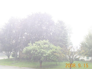
In this picture the rain was so heavy you can't see the tree's to well it almost look's like Fog!

Here really show's how heavy it was as you can see the rain pooring off the roof like a stream!
The wind's were really high and we had a lot of tree limb's in our yard still at as I type this the wind's are gusty. We got a total rainfall amount of .90 at this time here in Lafayette IN, It was coming down fast and the rain was totaling up fast as well..... It's not everyday we in Indiana see something like this and it sure was something! It looked like a hurricane out there sometime's. I went out to get these picture's and as im sure you know I got soaked!!!!! But it was fun as long as no one got hurt. We can all sleep well tonight!!!!! which Im sure you all are looking forward to.
Have a great day.....
Watches and advisory.....
Update as of 11:14am.
The wind's will hold off till later this afternoon however there are a few weather watches and advisory to talk about. There is a flash flood warning out for Benton, Newton, and Jasper, countie. There is some wind advisory's out for Tippecanoe, clinton, boon, montgomery, fountain, and carroll, countie's. Still the wind gusts look to be between 35 and 45 mph. The heavy heavy rain's are staying up over in I'LL, and north IN, still we will have our heavy rain's just not like what they will have up north and west. I will keep you updated as needed.....
The wind's will hold off till later this afternoon however there are a few weather watches and advisory to talk about. There is a flash flood warning out for Benton, Newton, and Jasper, countie. There is some wind advisory's out for Tippecanoe, clinton, boon, montgomery, fountain, and carroll, countie's. Still the wind gusts look to be between 35 and 45 mph. The heavy heavy rain's are staying up over in I'LL, and north IN, still we will have our heavy rain's just not like what they will have up north and west. I will keep you updated as needed.....
Saturday, September 13, 2008
High wind gusts and heavy rain's are on the way for tonight.
Well we have new update's to talk about and one of the think's I have been watching very closely all day is wind gusts. We could see some very high wind gusts as high as 40 to 45mph!!!!! starting in the morning after 9:00am or 10:00am and could go through 3:00pm before it die's down. That and rainfall we could also see rainfall as high as 3" inches. Not only that but so far today we have been haveing some high wind gusts of around 30 mph and we could see this till around 7:00pm before it die's out.  Most of us got a quick wake up earlyer this morning by our weather radio's with a tornado watch! thank goodness there was no tornado reports. Most of the storm's stayed up by Newton, Jasper, and Benton, countie. Back here in Lafayette we had a total rainfall amount of .30" this morning but other places like up in Jasper, countie had 1.12" 1.29" and 101" inches in there rain gauge's. So we will keep a close watch on thing's tonight I will be right here keeping watch for as long as I can. It is not everyday we get a tropical depression! in our area!!
So stay tuned and stay safe.....
Most of us got a quick wake up earlyer this morning by our weather radio's with a tornado watch! thank goodness there was no tornado reports. Most of the storm's stayed up by Newton, Jasper, and Benton, countie. Back here in Lafayette we had a total rainfall amount of .30" this morning but other places like up in Jasper, countie had 1.12" 1.29" and 101" inches in there rain gauge's. So we will keep a close watch on thing's tonight I will be right here keeping watch for as long as I can. It is not everyday we get a tropical depression! in our area!!So stay tuned and stay safe.....
Friday, September 12, 2008
Weekend forecast and a wet one it is.....
Well Hurricane Ike is one of the biggest hurricane's I have ever seen in my life! And it will bring us our biggest rainfall of the year!. Here is the latest picture of Ike.
 Ike is still currently a CAT 2 hurricane and as of now I think it will stay a CAT 2 when it make's landfall. The MAX wind's have been 110 mph to become a CAT 3 the wind's need to be at 111 mph so yes it is close but the MAX wind's have been at 110 mph all day and it is in the warm water's now and still is a CAT 2 so I think it will stay a CAT 2 hurricane when it make's landfall. Now for what we can expect for this weekend back here at home!. Let me tell you RAIN! The rainfall amount's still hold up at around 2 to 4" inches there is a chance we could see more in heavyer band's. Now other then flood watches we also need to watch out for high wind gusts. We could see wind gusts as high as 40mph maybe 45mph Saturday (tomorrow) later in the evening to that night! I have a feeling we all will be picking up tree limb's tomorrow! There is still a slight chance of some Sca-T storm's later that night into early early morning Sunday but as of now nothing is set in stone I will have more on this tomorrow. Yes we can still expect some low land flooding as well. So we have a wild weekend ahead of us and I will do my best to keep you all with the latest info.
And now Bless all who is in the path of Ike and let them all be safe.....
I will see you soon.....
Flood watch!!!!!
Well let the watches roll in!!!!!
The NWS has just put out a flood watch for Benton, Newton, jasper, Pualski, Cass, White, and Fulton, countie.
A flood watch mean's what it say's. It is possible for a flood so keep watch.
As of now we still can expect some high wind gusts on Saturday (Tomorrow) in the afternoon anywere from 25 to 30 Mph some could gusts as high as 35 Mph. The rain still hold's as well anywere from 2 to 4 Inches. Also for saturday (tomorrow) we will be in a slight risk for severe weather but we are not looking for any of that till late the day into sunday early morning so stay tuned.
I will keep you updated as needed and I will see you soon.
The latest.....
Rain update as of 10:07am.
Here is the latest map of Hurricane Ike you can see it makeing it's way to the land of TX.
It is still expected to make landfall as a CAT 3 which is a major Hurricane we think this will became a CAT 3 for at least one thing the water's are very very warm closer to TX. Here is a map track as to were it is expected to go after it's on land take a look below.

You can see it go's right through the Indiana area. And note it is still expected to be a tropical depression by the time it get's to the Lafayette Indiana area. This is something I have never seen before in my life!!!!! Still flooding is something we will need to watch the rainfall amount's still hold strong at 2 to 4 and maybe 5 inches in heavyer band's. Wind gusts will be something else we need to watch out for as tomorrow (Saturday) we could see wind gusts as high as 20 to 30 Mph maybe 35 Mph. So I will keep you all updated as new update's come in.
I will see you soon.
Thursday, September 11, 2008
How much rain is coming?
The rain is on the way as soon as later tonight!!!!!

How much rain could we see when all is said and done? And will flooding be something we need to watch?
Well the rain is expected to start around 12:00am or 1:00am tonight so I hope you all got all your outdoor work done. :) Now could we be worried about flooding? well I would watch out for some low land flooding and most likely the wabash! I say this because we could see around an inch to two inches of rain on Friday (Tomorrow) and another two or more inches on Saturday add all this up and your talking around 4 inches and it is possible we could see more yet as this rain could go on through Sunday!!!!!. So stay tuned to the blog for more update's as they come in. Here is a big flood tip Don't drive into any standing water because you may not know just how deep it is and that can be very very dangerous! So be smart and be safe and you will be OK!.....
Try to stay DRY in this WET weather!!!!! I will see you soon. :)
Heavy rain is on the way.....
Here is just a quick update on what we all can expect here in Lafayette IN, for late tonight into Friday.
The rain is expected to start around 12:00am or 1:00am Friday also for Friday we could have around a half to three quater's of an inch of rain and that is just for Friday we will be haveing rain possible through Monday. We will really need to watch out for flooding this is all because of what will be left of Hurricane Ike. Some good news is we are not in a severe weather risk for Friday at all as of now. So because of all the rain that is expected if you have any outside work to be done that you might want to get it done today before it all start's. Also for Friday we could see some wind gusts of 20 to 30 MPH. So as you can see it will be a very very wet few day's.
It will be a great few day's to set on the sofa and enjoy the sound of the rain let's just hope we don't get any bad flooding. I will keep watch and keep the blog updated.....
Have a great day.....
Tuesday, September 9, 2008
We are up and down in temp's and more rain is in the forecast!
 It is feeling more and more like fall then you all think. By that I mean nice cool temp's down in the 60s then back to the warm 80s. This up and down patteren is more like a fall like patteren which we will slowly start to feel more of these 60* day's as we get more into fall. One thing we need to watch with this fall like patteren is storms. This is because you get the stronger cold fronts moveing in from the north and the warmer more mild humid air moveing in from the south and this can fire up some stronger storms. As we get more into the year in later month's I mean like Sep, Oct, the cold fronts get stronger as we lose some of our daylight and heating And this is why fall as I have heard is our 2nd stormy season.

And one more thing take a look at Hurricane Ike you can see in this picture the darker color's red in TX is were it is expected to hit land. As of now it is expected to make landfall on TX, as a CAT 3 which is a major Hurricane.
Well I had better got moveing and get some stuff done so everyone have a great day and you can bet that I'll be back later to keep you all updated on what we can expect over this weekend. Have a great day and make it a good one :)
Monday, September 8, 2008
A nice quite night and a cool morning to look forward to.
Thing's are looking sooooo much better the storms have moved out of our area.
Thing's are nice and quite. You all can sleep well knowing that all the watches and or warning's are now over. It sure has been a wild night and now it look's like all we have to worrie about is going to be some chillie weather in the morning. So on your way to work school and even out for a jog don't forget to put on a jacket for it will be a chillie one out there. This is the time of year that the temp's go up and right back down it's just something we have to get use to lol :)

So everyone sleep well and don't let the bed bug's bite. :)
Thing's are nice and quite. You all can sleep well knowing that all the watches and or warning's are now over. It sure has been a wild night and now it look's like all we have to worrie about is going to be some chillie weather in the morning. So on your way to work school and even out for a jog don't forget to put on a jacket for it will be a chillie one out there. This is the time of year that the temp's go up and right back down it's just something we have to get use to lol :)
So everyone sleep well and don't let the bed bug's bite. :)
Tippecanoe fountain and north montgomery countie is now out of the severe thunderstorm warning however fountain co, is still in a severe thunderstorm watch till 3:00am and south montgomery countie is still in a severe thunderstorm warning. They still havs some strong storms in there area with half dollar size hail and very heavy rainfall. the system is moveing east at around 29MPH. I will keep you updated. People in south montgomery co, stay safe.
Big boom's
As of 9:23pm.
So far we have had one slightly strong cell move through our area in Lafayette IN, that is why I said I would not rule out a pop up strong storm or two for today. Now we still have to deal with rain for a bit and we will keep a close watch for anymore pop up's.
Now there is a severe thunderstorm watch out for fountain, montgomery, warren, and vermillion, countie till around 3am. I will keep you updated if needed.
Rain on the way.
Hey everyone it's great to check in with you all and I have some thing's to talk to you all about.
We have more rain in the forecast for tonight and here is the low down.
The good news is we are not in a severe weather risk. As of right now look's like the main thing's to keep watch for is going to be rain. We could see rainfall amounts between a quater and a half of an inch possible. The rain look's to want to start around 10:00pm tonight however we could start to see some pop up scattered showers around 7:00pm this evening. Now even though we are not in a severe weather risk right now Im still not going to rule out a good thunderstorm pop up either. Thing's right now look to be on track and if anything chenges I will let you know so for now get out and enjoy your day. Tomorrow is looking nice and cool with a high only around 67*.
I will keep you updated if needed have a great day.
Friday, September 5, 2008
A mild week ahead.
Well what a nice cool fall like day it was today we only had a high of 69.6*.
And I will tell you how we could see more mild temp's in the forecast just read on LOL.....
The week ahead is looking nice cool and great with high temp's only in the low to mid 70s how dose that sound?. Also we are not expecting to see anymore rain till maybe Monday with only a 40% chance of showers.
Now a tropical update.

Ike is already a CAT 3 and is expected to become a CAT 4. This is a major hurricane and needs to be watched. As of now it can go more east like Hanna, it can go more west or it could go in to the gulf which like I have been saying all week we don't want that to happen. As Ike move's in I will do my best to keep you all updated but for now it is still a way's out there.
So again the week ahead is looking just great with cool temp's. I was checking out a few thing's and it look's like we will really start to feel the cooler temp's by around Oct 12th maybe before. So that give's all the cool weather lover's something to look forward to. That and a mild week ahead have a great day!
Checking out your forecast. Coming up.
Here coming up I will tell you all about some cooler temp's back in the forecast were is and were will hurricane Ike go and when could we see our next rain all coming up here on the blog later on this evening so check back soon.
Thursday, September 4, 2008
More rain on the way and possible thunderstorms.....
We got more rain in the forecast YA still we need to watch it for the rain is coming from what is left of Gustav.
We are in a slight risk for severe weather for today and the thunder cast has us in a slight chance of seeing any thunder so we may or may not get any bad storms. The good news is the risk of any super cell's is very low at this point and time. Still we will watch this because the system still has a counter clockwise movement and if there is enough windshear that would not be good.
Some more good news is there has been no reports with this system today and the only watches and or warning's is some flood warning's over in south ILL,.
We this morning woke up to a total rainfall of 1.00" inch. Yesterday we got .70" of an inch.
So for now enjoy your day and if you go out don't forget to take your umbrella.
I will keep you updated if needed.....
Wednesday, September 3, 2008
Your winter weather forecast and a Hurricane update.....
 Well I said I would have you a winter forecast and I got it. For all you snow lover's you will like this forecast. Let me just point out this picture above is that not the best picture you have ever seen LOL!!!!! :)
Ok now time for your winter weather forecast.
We the midwest will see above normal snowfall especially in Jan and Feb.
We could also see our first snow as soon as mid Nov. They are saying snow at thanksgiving will signal the coming of a very cold period. How dose that sound snow lovers? I am a BIG SNOW LOVER and I am looking soooo forward to this winter forecast!!!!! Also by around Oct 12th the colder temp's will start to move in.
 Now a quick hurricane update. Here are some picture's of hurricane IKE, now there are two other's out there as well but I am telling you all about Ike because it has a chance to go in to the gulf like Gustav did. We really don't want that to happen This hurricane is already a CAT 3 major Hurricane. If you take a look at this map just above you can tell that it look's like it could take the same path as hurricane Gustav did. So for now let's just cross our fingers and hope it dose not go to the gulf again.....
So everyone enjoy your night and don't forget the first day of fall start's on SEP 22nd.....
Is there rain in the forecast?????
Well the BIG question is WERE IS THE RAIN?????
Well we could very well see some rain in the forecast tonight in to tomorrow and I have some rainfall total's that's right I said rainfall total's something we have not seen in a good time.
We have a 55% chance of rain tomorrow (Thursday) with rainfall amount's between a quater and a half of an inch possible!!!!! YES!!!!! Iam soooooooo happy to give you a rain forecast for we have not had rain in a long time at least in feel's like a long time!
Another thing to talk about is how hot it was yesterday we had a temp of around 94* WOW but on the better side we are now going to start to cool off as temps start to go back down to around the mid 70s. With all this talk about hot and dry weather would you all like to have a early winter forecast? Well stick around and I will have your winter outlook here on the blog later on today! Also it is getting close to the frist day of autumn which start's on the 22nd of this month. Halloween is also getting close I know I know you think Im rushing thing's lol.....
Also coming up I will give you a hurricane update there are more hurricane's out there and at least one of them named IKE, could make it back in to the gulf again which they really don't need so be sure to check back soon. Enjoy your day.....
Tuesday, September 2, 2008
One more hot day to get through.
Well Gustav has been some Hurricane and is now a tropical drpression. It knocked out the power in a good part of LA, I know of Baton Rouge, for sure. Some good news is the levee's did hold up thank goodness in new orleans, which was a big thing everyone was worried about. Also there is more hurricanes out there and there is a chance at least one of them could go in to the gulf again so we need to watch them very closely we do not want another one.
Now let's get back to weather here at home in Indiana,
Frist off I would like to say what a great job the people at WLFI TV 18 NEW'S did yesterday for jerry's kid's MDA and what a great job all the people did who called in to make a donation and all the volunteer's. They raised a lot of money to help Jerry's kid's GREAT JOB EVERYONE!!!!!
Now back to weather. We have one more day of hot weather to get through and that day is today we could see temps up around 90* HOT! after today will slowly start to cool down. Tomorrow we could see temps around 84* and on Thursday we really start to cool down with high's only around the low 70s. Late tomorrow in to Thursday we have a 30% to 50% chance of Iso-T showers. Otherwise the week don't look bad.
So everyone enjoy your day just don't stay out in the sun to long LOL..... Have a great day....
Monday, September 1, 2008
Gustav made land fall
Gustav is on land as a CAT 2.
I have been watching this storm for some time and I have just found out that the levee's in new orleans are very lose and could break here before long and that is something we don't want to happen as you know!
I have a friend down in Baton rouge LA, and said they were getting some heavy rain's and wind.
Storm surge is another thing to watch I was looking at some map's and new orleans could see storm surge anywere from 9 to 12 feet high!!!!!
So any family down there keep in touch with one another. I have been keeping it touch with my friend in Baton rouge by E-Mail. Stay safe. God bless everyone.
Subscribe to:
Posts (Atom)