Breaking Story From Fox News.
BREAKING NEWS — President Michele Bachelet declared a state of catastrophe in central Chile after a massive 8.8-magnitude earthquake struck early Saturday.
The most powerful quake to hit the country in a half century cut electricity, water and phone lines to many areas, meaning there was no word of death or damage from many outlying areas.
There have been conflicting reports on the death toll, with some placing the count as high as 122, a number Chilean officials expect to rise.
U.S. State Department spokesman P.J. Crowley told Fox News that the embassy is reaching out to the Chilean government to offer assistance. He reported that the 100 personnel at the embassy are OK and accounted for.
"Chile has both significant capabilities and strong building codes. Second, the Embassy has activated its Warden system to communicate with Americans in Chile and make sure they are okay," Crowley said.
The quake epicenter was just 70 miles from Concepcion, Chile's second-largest city, where more than 200,000 people live along the Bio Bio river, and 60 miles from the ski town of Chillan, a gateway to Andean ski resorts that was destroyed in a 1939 earthquake.
In Santiago, the capital, modern buildings are built to withstand earthquakes, but many older ones were heavily damaged, including the Nuestra Senora de la Providencia church, whose bell tower collapsed.
In the coastal city of Vina del Mar, the earthquake struck just as people were leaving a disco, Julio Alvarez told Radio Cooperativa in Santiago. "It was very bad, people were screaming, some people were running, others appeared paralyzed. I was one of them."
Several hospitals have been evacuated due to earthquake damage, she said, and communications with the city of Concepcion remained down. She planned to tour the affected region as quickly as possible to get a better idea of the damage.
The Pacific Tsunami Warning Center called for "urgent action to protect lives and property" in Hawaii, which is among 53 nations, territories and states subject to tsunami warnings.
"Sea level readings indicate a tsunami was generated. It may have been destructive along coasts near the earthquake epicenter and could also be a threat to more distant coasts," the warning center said. It did not expect a tsunami along the west of the U.S. or Canada but was continuing to monitor the situation.
The largest earthquake ever recorded struck the same area of Chile on May 22, 1960. The magnitude-9.5 quake killed 1,655 people and left 2 million homeless. The tsunami that it caused killed people in Hawaii, Japan and the Philippines and caused damage to the west coast of the United States.

Saturday, February 27, 2010
Friday, February 26, 2010
Snow Showers Move In Tonight Through Saturday Morning...

You can see in this satellite image above that we are expecting to see bands of snow from this area of low pressure try and move into the area later on tonight and then into Saturday. This is such a big area of low pressure that we could pick up a little accumulation as well. However not much!
There are a few winter weather advisories in effect to our east for areas pretty much from I69 West. This is where they will see slightly higher amounts from this system. Now because the bands of snow are coming from our north east this means that this system will act like an Alberta clipper. And by that I mean we will have no moisture to work with from the golf. Which is usually when we see bigger snow in our area. So just how much are we talking about? Let's check it out below.

As you can see I went ahead and put most of us in that Trace To 2" inch range. This is because most models are agreeing that there won't be much moisture. Also the MOS models are showing a QPF of 0 to 1. Which means most of us will pick up between a Trace and an inch possible. However a few local areas could see closer to and inch with blowing snow to 1.5" inches in spots. However the higher amounts such as 1" to 2" inches will be around I69 and then West of there. So really nothing big to talk about this time around here in Indiana or the WLFI viewing area. Just snow showers moving in tonight into tomorrow. And winds between 10 and 20 mph gusting near 25 mph possible.
So stay warm and stay safe! Even this little bit of snow can and does make things slick to start!
I'll check back soon.....
Stay Safe!
Thursday, February 25, 2010
Quick Cast Update...
We did see snow outside in the Indiana area yesterday however we didn't see much! In my last blog post we were looking for less then an inch of snowfall. However this time around we picked up near that with 1.3" inches here in the Lafayette, area. The thing with this snowfall was it fall as an extremely light snow. If you picked it up and tossed it into the air to looked like dust! This is why it added up to 1.3" inches. Had this fell as a heavier snow we may have only recorded around a half inch or less. It all come down to how heavy the snow pack is.
Now let's go ahead and take a look at the temperature outlook map below.
You can see above that yesterday's high was around 27.5° degrees. However the average temperature for this time of year is between 40° and 44° degrees °F. With that said this means we have been around a good 17° degrees below average! That's a big difference. So now the question is "When will we see temperatures get back to near average?" Well, I have gone through some more MOS, data as well as some 850mb temperature plots and I'm seeing the average temperatures try and move back into the forecast by late week into next week! When temperature could hit near 40° degrees! That will feel like a heat wave after seeing temperatures in the 20s for the past few days. If anything this gives you something to look forward to! ;)
Now as for what we have to expect today this map above says it all. We will continue to watch those snow showers move off to the east slowly but surly. While the rest of us see some mostly to partly cloudy skies over the area. I think we have a good chance at seeing some peaks of sun on both Today and Friday! Temperatures will be in the low 30s today with lows tonight in the low 20s around 21° degrees. Here's your quick cast below.
Quick Cast.......................................
Today we will look for some mostly cloudy to partly cloudy skies over the viewing area. Highs will be in the low 30s around 34° degrees with lows falling into the low 20s around 21° degrees. Winds will be light between 5 and 10 mph with a few gusts near 15 mph possible.
Friday we will look for much of the same with more mostly to partly cloudy skies over the viewing area. Again highs will be in the lower 30s around 33° degrees with lows in the low 20s around 21° degrees. Winds will be slightly higher between 5 and 10 mph with a few gusts to 15 - 20 mph possible.
~~~~~~~~~~~~~~~~~~~~~~~~~~
~~~~~~~~~~~~~~~~~~~~~~~~~~~~~~~
As I said above come next week we will start to see more average like high temperatures try and move into the area. However the lows still look to be running a few degrees below average. Average lows for this time of year run around 26° to 27° degrees °F. So for tonight and tomorrow's low temperatures we will be running around 4° to 5° degrees below average. Which is really not to bad!
With Spring not being far off we can all keep hope for nice mild "NOT HOT" temperatures to be on the way! ;) lol.
I'll check back soon.
Wednesday, February 24, 2010
Check Back Later On For The Late Night Quick Cast!
I'll have a quick blog update posted later on tonight talking about how much snow we have seen today as well as temperatures, And then what we have in store for the rest of this week. All this coming up late tonight in the Late night quick cast!
see you then!
DEVELOPING UPDATE..................
see you then!
DEVELOPING UPDATE..................
Monday, February 22, 2010
Spring Is Not Here Yet As We Have Another Blast Of Winter Air About To Arrive!
Well, we have had a lot of rain move through the area but the good news is it has pushed off to the east and we are finished with it for a while! First lets go ahead and take a loot at some rainfall reports I have recorded below from around the area.
Final Rainfall Totals.
Kentland, .73" Inches.
JIWB, Lafayette, .60" Inches.
Otterbein, .52" Inches.
Remington, .52" Inches.
Attica, .51" Inches.
Logansport, .49" Inches.
 You can see the system pushing off to our east in this satellite radar image above. So for the rest of today we can still expect to see lots of cloudy skies over the viewing area. With light winds between 3 and 5 mph. Everything is still very soggy so I would keep the covers of the sofa if you have dogs lol. It is becoming that time of year when everything stay wet of weeks! Yes, the change from Winter to Spring is almost here. The first day of Spring is March 20th. Not far at all. However I don't see spring coming before we see yet another cold BLAST of winter air! Take a look at this map below.
 This is a look at how things are expected to play out come Wednesday. We will watch the cold air continue to build to our north between now and Tuesday. Then start to move into our area by Tuesday night with temperatures falling into the low 20s. Then highs on Wednesday will only be around 24 degrees with lows falling back into the teens around 14 degrees! Yes, Winter doesn't want to give up just yet! The past few days have only been a teaser with highs hitting in the 40s! This is about the time of year that many people start getting cabin fever. Just hang in there! ;)
Quick Cast...................................
Tuesday we will keep in around a 25% chance of a few light hit and miss scattered snow flurries to showers around the viewing area. Nothing will accumulate to much if anything. Highs will be in the lower 30s around 34 degrees as the cold blast starts to make a move on us by that night. Lows will fall into the low 20s around 24 degrees. Winds will be calm between 3 and 5 mph.
Wednesday we will also keep in a slight 20% to 30% chance of a few light hit and miss scattered show showers through out the viewing area. Snowfall looks to be less then an inch. Highs will be cool in the low 20s as that cold winter air arrives in our area once again making highs around 24 degrees. Lows will drop that night into the lower teens around 14 degrees! Brrrrrrrrrrrrrr. Winds will be rather calm between 10 and 15 mph.
~~~~~~~~~~~~~~~~~~~~~~~~~~~~~~~
~~~~~~~~~~~~~~~~~~~~~~~~~~~~~~~~~
I'm not currently seeing any bigger system to track this week, other then the few scattered snow showers off and on between now and as we head closer to the weekend. So for now just be ready for another taste of winter cold as we count down to the first day of spring!
I'll check back soon.....
Final Rainfall Totals.
Kentland, .73" Inches.
JIWB, Lafayette, .60" Inches.
Otterbein, .52" Inches.
Remington, .52" Inches.
Attica, .51" Inches.
Logansport, .49" Inches.
You can see the system pushing off to our east in this satellite radar image above. So for the rest of today we can still expect to see lots of cloudy skies over the viewing area. With light winds between 3 and 5 mph. Everything is still very soggy so I would keep the covers of the sofa if you have dogs lol. It is becoming that time of year when everything stay wet of weeks! Yes, the change from Winter to Spring is almost here. The first day of Spring is March 20th. Not far at all. However I don't see spring coming before we see yet another cold BLAST of winter air! Take a look at this map below.This is a look at how things are expected to play out come Wednesday. We will watch the cold air continue to build to our north between now and Tuesday. Then start to move into our area by Tuesday night with temperatures falling into the low 20s. Then highs on Wednesday will only be around 24 degrees with lows falling back into the teens around 14 degrees! Yes, Winter doesn't want to give up just yet! The past few days have only been a teaser with highs hitting in the 40s! This is about the time of year that many people start getting cabin fever. Just hang in there! ;)Quick Cast...................................
Tuesday we will keep in around a 25% chance of a few light hit and miss scattered snow flurries to showers around the viewing area. Nothing will accumulate to much if anything. Highs will be in the lower 30s around 34 degrees as the cold blast starts to make a move on us by that night. Lows will fall into the low 20s around 24 degrees. Winds will be calm between 3 and 5 mph.
Wednesday we will also keep in a slight 20% to 30% chance of a few light hit and miss scattered show showers through out the viewing area. Snowfall looks to be less then an inch. Highs will be cool in the low 20s as that cold winter air arrives in our area once again making highs around 24 degrees. Lows will drop that night into the lower teens around 14 degrees! Brrrrrrrrrrrrrr. Winds will be rather calm between 10 and 15 mph.
~~~~~~~~~~~~~~~~~~~~~~~~~~~~~~~
~~~~~~~~~~~~~~~~~~~~~~~~~~~~~~~~~
I'm not currently seeing any bigger system to track this week, other then the few scattered snow showers off and on between now and as we head closer to the weekend. So for now just be ready for another taste of winter cold as we count down to the first day of spring!
I'll check back soon.....
Sunday, February 21, 2010
(Sidewalks) Rain On Ice Is Dangerous!
It is just down right SOGGY outside right now. The rain has been coming down all day and heavy at times. Mainly the past two hours! Lafayette, has already picked up .30" inches with more still to come. We have stayed well above the freezing mark today and just like expected in my older post, the 540 line has lifted north so the whole viewing area or really the whole state on Indiana is seeing nothing but rain as we continue to be on the warm side of this system. This system has started shifting more North East rather then East north east like earlier! So some of the training has stopped in our southern counties.
Take a look at this Regional radar image below.
 We will look for this rain to continue through out tonight into tomorrow before tapering off Monday night. We can expect another quarter inch to a half inch on top of what has already come down.
Stay safe bloggers and be sure to post your rainfall totals. I will try and have more rainfall totals posted for you all by tomorrow afternoon or so! Thanks for reading. I'll check back as needed.
Take a look at this Regional radar image below.
You can see this huge system and where the freeze line is. And that's not in Indiana lol. You see where all the snow is setting up. This is where they could see 4" to 6" inches! While we stick with close to an inch of rain! The radar is showing that most of us have picked up under a half inch of rain up to this point and time. However we will continue to add to those totals through out the night. As you can see above we still have a lot of precipitation to get though! The good news is some of our southern counties such as Montgomery, and Fountain, counties are about to see a little break in the rain! As this system continues to lift north east we will see the rain stop if only for a little while. Take a look. Just don't be fooled because like I said above we do still have a lot more to come!
Just don't be fooled because like I said above we do still have a lot more to come! Still not looking for any flooding on the area rivers as the rain has not been coming down to heavy and or fast. But the ground is having a hard time soaking it up! When you walk and hear the soggy squish under your feet then you know it's WET! Just look at these pictures telling the story nicely outside as I type...  Soggy slick sidewalks and lots of puddling water around the area. When this water sit on top of what little ice that's left on the walkways it can become dangerous! So please take you time walking and stay safe.....
Soggy slick sidewalks and lots of puddling water around the area. When this water sit on top of what little ice that's left on the walkways it can become dangerous! So please take you time walking and stay safe.....We will look for this rain to continue through out tonight into tomorrow before tapering off Monday night. We can expect another quarter inch to a half inch on top of what has already come down.Stay safe bloggers and be sure to post your rainfall totals. I will try and have more rainfall totals posted for you all by tomorrow afternoon or so! Thanks for reading. I'll check back as needed.
Rainy Soggy Update!
We have been watching the light rain move through the area all morning. The good news is it has not been coming down in sheets!
I have gone through more data this morning and currently everything is still looking on track. Even though we have been seeing all rain up to this point some models are still showing a mix possible at times. And believe it or not the mixed precipitation is not far away for Lafayette as I type! It is setting up just to our north in areas around Benton, White, And parts of northern Carroll, counties. Take a look at this national satellite radar image below. This image was taken at 10:50am EST this morning and you can see the system very well moving into the area. This system is moving east north east and is doing some training. Which means it's kinda like a train on tracks, It just keeps coming over our area. Sometimes this can cause flooding but the good news is we are not expecting any flooding on the area rivers! Rainfal is just not heavy enough which is great news! But we can expect LOTS and LOTS of wet soggy grounds. Anyone who has dogs should love this lol :)
Now lets get a closer look at this system with my local radar below. This image was also taken at 10:50am EST this morning. You can see where that 540 line is currently set up. I have gone ahead and pointed to the areas that are seeing the mixed precipitation and the areas that are seeing rain. Now this may not be coming down as a heavy mix or anything just yet as this is still trying to change over from all rain. With temperature this warm it's not easy! And most areas are only seeing rain falling at a rate of a Tenth inch an hour! "Very Light" Lafayette, is not going to see a mix for a while as our temperatures are still standing at 37.8 degrees. So rain is looking good at this time! For most of us this is going to be a rain event. Only our northern counties will see the mix until later on late tonight into Monday then we have a chance at a mix to scattered snow showers. Again it will be Light! So as we head into the evening hours to tonight and start to cool to near freezing then we will watch as some of this rain on the back side will try to change over to some light scattered snow showers into Monday. Now I don't see that adding up to much if anything because the ground will be to wet and by this time most of the storms energy will be passed the area.
I have gone through more data this morning and currently everything is still looking on track. Even though we have been seeing all rain up to this point some models are still showing a mix possible at times. And believe it or not the mixed precipitation is not far away for Lafayette as I type! It is setting up just to our north in areas around Benton, White, And parts of northern Carroll, counties. Take a look at this national satellite radar image below.
This image was taken at 10:50am EST this morning and you can see the system very well moving into the area. This system is moving east north east and is doing some training. Which means it's kinda like a train on tracks, It just keeps coming over our area. Sometimes this can cause flooding but the good news is we are not expecting any flooding on the area rivers! Rainfal is just not heavy enough which is great news! But we can expect LOTS and LOTS of wet soggy grounds. Anyone who has dogs should love this lol :)Now lets get a closer look at this system with my local radar below.
This image was also taken at 10:50am EST this morning. You can see where that 540 line is currently set up. I have gone ahead and pointed to the areas that are seeing the mixed precipitation and the areas that are seeing rain. Now this may not be coming down as a heavy mix or anything just yet as this is still trying to change over from all rain. With temperature this warm it's not easy! And most areas are only seeing rain falling at a rate of a Tenth inch an hour! "Very Light" Lafayette, is not going to see a mix for a while as our temperatures are still standing at 37.8 degrees. So rain is looking good at this time! For most of us this is going to be a rain event. Only our northern counties will see the mix until later on late tonight into Monday then we have a chance at a mix to scattered snow showers. Again it will be Light! So as we head into the evening hours to tonight and start to cool to near freezing then we will watch as some of this rain on the back side will try to change over to some light scattered snow showers into Monday. Now I don't see that adding up to much if anything because the ground will be to wet and by this time most of the storms energy will be passed the area.We have not picked up over a quarter inch just yet as well. But I still look for precipitation between a quarter and a half inch possible today into tonight with another tenth inch to a quarter inch on Monday.
For now all we have to do is continue to watch the radars and keep dry! Things still look on track...
I'll check back as needed if anything is to change!
A Very Wet Weather Event Is Still The Forecast...
It is after midnight and the temperature is still at 34.7 degrees. Yes, still above freezing which will continue to keep our precipitation in the form of rain or mix at this time. The really light rain to mix has been moving into the western counties for the past hour however things will become more widespread as the day goes on.
Things still look on track at this time.
I'm going to try and get some sleep. I had a good 2.6 mile run earlier and could use some rest! lol. I will check back by this afternoon once again with yet another weather update!
We will continue to watch this system as it unfolds over today into tonight / Monday so we all can stay on top of things!
Saturday, February 20, 2010
One Big Mess Of A System!
Well, first off we did see our expected snowfall last night into the early morning from system number one. We called for less then an inch of snow accumulation and that's just what the viewing area seen as they woke up! I have a few snowfall reports posted below for you to check out. Take a look...
Saturday Snowfall Reports...
JIWB, Lafayette, 0.5" Inches.
Kentland, 0.5" Inches.
Attica, 0.5" Inches.
Indianapolis, 0.5" Inches.
Otterbein, 0.4" Inches.
Remington, 0.2" Inches.
You can see most of us came in with right around that half inch mark. When I went out to check my gauge I also noticed something different! What's that? Well, it was much more mild then it has been all week. If you got a chance to get out yesterday then you know what I'm talking about! Yesterday we hit a high of 41 degrees in Lafayette. I was out in just a light jacket. And it was nice I have to say! Well, today when I walked out it was around 36 degrees and felt nice and warm. Kinda like a warm snow lol. Well, it's 38 degrees now and still expected to get a little warmer by this afternoon. This is another reason heavy snowfall is looking less likely Sunday into Monday.
The models are finally starting to agree this morning for the first time this week. This is why we take our time while forecasting and don't jump to amounts. You all remember me talking about the low pressure track yesterday and early this morning. Well, take a look at the latest Low track I have below. Even the GFS model is agreeing that this is the best low track for this system. With the low moving so far to the north this is really going to keep the heavy snowfall out of our area. The places to see the heavy snow will be well to our north west in northern IL, Which means lots of wet weather starting later Sunday into Monday. You can see how this low tracking more to the north effects the 540 line as well. Take a look below.
 The lines above are all 540 lines. This map is showing where the lines are expected to be at different times. The Red line is where the 540 will set up for the most time. This is looking at 1:pm Sunday. The Pink line is how far north it is expected to drift once the low really starts to move into the area. This is looking at 7:am Monday. And then the last line, (The blue line) is how far south it will drop after the low starts to move out of the area by 7:pm Monday night.
Saturday Snowfall Reports...
JIWB, Lafayette, 0.5" Inches.
Kentland, 0.5" Inches.
Attica, 0.5" Inches.
Indianapolis, 0.5" Inches.
Otterbein, 0.4" Inches.
Remington, 0.2" Inches.
You can see most of us came in with right around that half inch mark. When I went out to check my gauge I also noticed something different! What's that? Well, it was much more mild then it has been all week. If you got a chance to get out yesterday then you know what I'm talking about! Yesterday we hit a high of 41 degrees in Lafayette. I was out in just a light jacket. And it was nice I have to say! Well, today when I walked out it was around 36 degrees and felt nice and warm. Kinda like a warm snow lol. Well, it's 38 degrees now and still expected to get a little warmer by this afternoon. This is another reason heavy snowfall is looking less likely Sunday into Monday.
The models are finally starting to agree this morning for the first time this week. This is why we take our time while forecasting and don't jump to amounts. You all remember me talking about the low pressure track yesterday and early this morning. Well, take a look at the latest Low track I have below.
Even the GFS model is agreeing that this is the best low track for this system. With the low moving so far to the north this is really going to keep the heavy snowfall out of our area. The places to see the heavy snow will be well to our north west in northern IL, Which means lots of wet weather starting later Sunday into Monday. You can see how this low tracking more to the north effects the 540 line as well. Take a look below.The lines above are all 540 lines. This map is showing where the lines are expected to be at different times. The Red line is where the 540 will set up for the most time. This is looking at 1:pm Sunday. The Pink line is how far north it is expected to drift once the low really starts to move into the area. This is looking at 7:am Monday. And then the last line, (The blue line) is how far south it will drop after the low starts to move out of the area by 7:pm Monday night.So what does this really mean for this system? Well, I think we look for Mixed precipitation late Sunday into Monday. Right now I'm not seeing a lot in the way of Ice accumulation! Which is good news for everyone! This is looking more like a wet mix of rain and snow more then anything! We could see a little freezing rain at times as that cannot be ruled out! But I'm not seeing it adding up to much at this time. Here's your detailed forecast below.
Sunday we will see cloudy skies to start things as the system continues to move closer and closer to the area. We will watch the system try and move in that afternoon to evening. A rain snow mix will develop with the chance at some freezing rain at times however not accumulating to much. New precipitation expected between a quarter and a half inch. Highs will be in the upper 30s to low 40s. With lows in the upper 20s. Winds between 5 and 10 mph.
Monday we will continue to see a rainy snowy mix over the area. Precipitation could be heavy at times. New precipitation expected between a half inch and three quarters of an inch possible. Highs look to be in the upper 30s to low 40s. With lows in the upper 20s to low 30s possible. Winds between 10 and 15 mph with gusts to 20 mph also possible.
Just a BIG mess is the forecast :) This is why it is so hard to give a specific rain amount or snow amount. Because just a slight shift of this low can give or take in rain or snow. So this is why we call it in expected "precipitation" amounts.
This is how things look at this time. I will check back as needed with any changes!
And wow can you believe that this is my 700th post to you guys and girls? WOW Thank you for making this blog so great! ;) You bloggers make this blog what it is!
Burning The Midnight Oil To Keep You Posted!
Well, it is late and I just ran through a few more weather models to see if we have a better handle on what this low pressure system is gonna do. And right now every model is tracking this low pressure more north then what it was showing earlier. Only the GFS model has the low setting up to the southern parts of Indiana. You can see the Current Expected Low track in this map I put together below.
You can see it's looking to be to far north for this to be an all snow event! So this could mean a wet system to start the work week. Now this still isn't set in stone as things could still change. However this is what I'm leaning towards at this time. So for now I'm going to get some sleep and I will try and go through some more model data this morning and have another system update by this afternoon some time! Stay tuned bloggers and stay storm ready! ;)
I will check back.....
Friday, February 19, 2010
Winter Tricks! This System Is Crazy!
Well, I have gone through the latest weather model data and I have to say that the weather models are not handling the Sunday / Monday system to well at this time. They are all over the place! However the system for later tonight into Saturday is looking good lol. So lets go ahead and start with that one first! ;)
You can see in this satellite radar image above taken at 11:07am EST this morning that the first system is really taking shape. This system is looking to fall as an all snow event. However it's not looking to bring us much in the way of snow accumulation. I'm currently looking at less then an inch of snow. But this is only the warm up to a much bigger and more tricky system.
Now everyone is saying that this system for Sunday into Monday is tricky however do you know why? Well, I'll let you know.
It is all coming down to the track of this low pressure. How does this effect snowfall amounts? Well, if the low pressure system tracks to far to the north then areas from Lafayette south may see a mixed precipitation and that would lower snowfall. As areas north of Lafayette, would be seeing some good size snow accumulations. However if this low tracks a little more south, then all of the viewing area would be tracking some heavy snowfall with bigger snow accumulation. Take a look at how one of the models has this system playing out below.
Now what your looking at above is what I like to use when forecasting snow and ice. This is called the 540 line. Some of you may already know about this. However for those who don't let me explain. The 540 line is kinda like a line that tells you what areas will see mixed precipitation and which ones will see all rain or all snow. Any precipitation to fall to the north of this line usually falls in the form of snow! While precipitation to fall south of this line usually falls as rain. And right around this line or should I say near by this line usually sees a mixed precipitation event.
And you can see above one model is showing this line setting up to give most of us a mixed precipitation event. However this is not by any means set in stone at this time! I have one model saying this will be an all snow event. While another is saying little snow and mostly a rain to mix event. The good news is I'm not seeing a major ice event for the viewing area at this time. The GFS models are showing this low pressure system setting up a bit north which would support this image above. However the European, weather models are showing it set up a bit more south which would support a snow event for our area. Now if we where to see this system move in as an all snow event we could be looking at a 4" to 6" inch range! However because the models are still having a hard time with the low pressure track I'm going to hold off on the snow amounts until we get a little closer! Things are just to wild at this time. Once we get a few more weather model runs under our belt then I will feel better about giving precipitation amounts! We still have around two days to really get a good grip on things!
So for now lets just focus on this first system with less then an inch of snowfall. This will move in late late tonight into early morning Saturday.
Stay tuned bloggers as I will have more on this developing system later!
Be sure to check back for the latest.....
Developing System Update...............
We do have some tricky weather systems trying to developing later on tonight and over the weekend, With another system to start the work week! I'm going to continue to watch the weather models closely and have a detailed weather forecast coming your way this afternoon!
Stay tuned!
DEVELOPING........................
Stay tuned!
DEVELOPING........................
Wednesday, February 17, 2010
I Have Seen Some Signs Of Spring! But Not Before Another Winter Weather Event Trys To Take Place Over The Indiana Area By This Weekend!
Well, we have two systems to watch starting this weekend and then another by the start of the work week. These systems currently look to give us a little taste of everything. Yes, this means Rain, Snow, and a Mixed, precipitation. What a mess we have in store that's for sure!
We hit a high yesterday of 34.7 degrees which a lot of people enjoyed! I was talking with one of my neighbors who said "We should have this snow gone in no time with these nicer temperatures" However I had to let her know about the wild weather on the way by this weekend! :) She wasn't to happy to hear about that! lol. However Cold weather aside for a minute, I may be on to something that all the bloggers waiting for Spring to arrive may like! Believe it or not I have seen a big increase in the Spring time insects. Yes, the little black ants and also spiders! YUCK!!!! I don't like bugs one bit lol but this could be a sign that spring is just around the corner!
Yes, Spring will be here before you know it! Spring is next month! It is on the 20th so be sure to mark your calender!! The count down begins! ;) Soon we will be watching the squirrels of Indiana jumping over our flowers lol. I have already seen some of the trees starting to bud around town. Yes, the signs are all around us.
You can send me your sings of Spring pictures at storm18mini@aol.com
In other weather events people were checking out the sky in areas of Arizona, the other night to see both Venus and Jupiter in the glow of the sunset skies! Take a look at this story below.
DIFFICULT, BUT BEAUTIFUL: Last night, Venus and Jupiter converged for a remarkable conjunction; at closest approach, the two bright planets were only 1/2-degree apart. Just one problem. The meeting occured deep in the glow of sunset: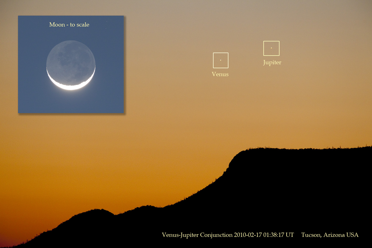 The event required crystal-clear skies for easy visibility. "Here in Arizona, we were able to see Venus and Jupiter with the naked eye," reports David Harvey from Tucson. "I shot the moon a few minutes after Jupiter set and inserted it for scale. It was a beautiful view."
Elsewhere, viewing the conjunction was more of an adventure. Some photographers conducted car chases to find gaps in clouds, while others climbed to rooftops for a better angle.
We hit a high yesterday of 34.7 degrees which a lot of people enjoyed! I was talking with one of my neighbors who said "We should have this snow gone in no time with these nicer temperatures" However I had to let her know about the wild weather on the way by this weekend! :) She wasn't to happy to hear about that! lol. However Cold weather aside for a minute, I may be on to something that all the bloggers waiting for Spring to arrive may like! Believe it or not I have seen a big increase in the Spring time insects. Yes, the little black ants and also spiders! YUCK!!!! I don't like bugs one bit lol but this could be a sign that spring is just around the corner!
Yes, Spring will be here before you know it! Spring is next month! It is on the 20th so be sure to mark your calender!! The count down begins! ;) Soon we will be watching the squirrels of Indiana jumping over our flowers lol. I have already seen some of the trees starting to bud around town. Yes, the signs are all around us.
You can send me your sings of Spring pictures at storm18mini@aol.com
Now let's check out what we have to look forward to by this weekend... You can see that I'm expecting the first storm to move in closer to Late Late Friday night into early Saturday morning. This system I'm currently expecting to bring in some snow showers with some light accumulation. Right now snowfall amounts are still a little tricky to call or set in stone however I will go ahead and give an idea range. Between 1" and 2" inches. And this will most likely change by my next update and things become more clear with the weather models! So be sure to check back for the latest! ;)
In other weather events people were checking out the sky in areas of Arizona, the other night to see both Venus and Jupiter in the glow of the sunset skies! Take a look at this story below.
DIFFICULT, BUT BEAUTIFUL: Last night, Venus and Jupiter converged for a remarkable conjunction; at closest approach, the two bright planets were only 1/2-degree apart. Just one problem. The meeting occured deep in the glow of sunset:
The event required crystal-clear skies for easy visibility. "Here in Arizona, we were able to see Venus and Jupiter with the naked eye," reports David Harvey from Tucson. "I shot the moon a few minutes after Jupiter set and inserted it for scale. It was a beautiful view."Elsewhere, viewing the conjunction was more of an adventure. Some photographers conducted car chases to find gaps in clouds, while others climbed to rooftops for a better angle.
Lafayette, IN, seen something close this this site earlier last year. When both the Moon and Jupiter was going to be side by side. We was able to view them both with the naked eye and let me tell you it was beautiful. You can see this image I took that night last year below. Well, bloggers I'm going to get off here and go enjoy the day! You do so as well! ;) Thanks for reading and I'll check back with more on these two developing systems again soon.....
Tuesday, February 16, 2010
Lafayette, IN, Temperatures Colder Then Vancouver, Canada?!?!
Hey bloggers. I just wanted to pop in real quick with some info about a few changes to JIWB that I'm in the process of doing. I'm going to fix up the URL a little and change this blog to a bigger and better format that will have much more on it for your weather blogging needs. It will look much better with this bigger format and has more tools for you to click on and will also have a feature called "JIWB Email Subscription" which will allow you to Click to subscribe to my Weather blog and receive free notifications of new posts by email. This should also help a lot in severe weather events!
I'm still setting things up at this point and time however I'm hoping to have things up and running by Saturday or Sunday. One of those two days is when I'm hoping to have the site totally up and running with no problems. So you can expect to see me pop in with the new URL by that time and then you will be able to check it out and enjoy! ;) I really think you will find this format much more to your liking.
Now lets go ahead and continue to watch our Indiana weather below with my new upadte!
And Thank You! :)
Well, the weather has been very winter like the past few days and really the whole month of February. And believe it or not Lafayette, has been colder then Vancouver Canada lately. Vancouver has been seeing daytime highs between 40 and 50 degrees. They have been having a hard time keeping the snow from melting by bringing in more snow by the truck loads. While Lafayette, has been seeing highs around 25 and 30 degrees. This is the warmest it has been in Vancouver in a while. And what a fine time for it to be above average right? They have been working hard however the athletes have been hanging in there and getting the job done.
And Team USA has been doing rather well up to this point and time. They have been leading the pack with eight medals. However currently they stand in 2nd place in the total medal count as Germany is ahead by one! GO TEAM USA!!!!
So what do we have in store for the rest of this week? Well, take a look at this radar image below.
You can see this radar image was taken at 7:21pm EST this evening. What we are looking at is the lake effect snowfall moving into some of our northern counties. This is just about all we have to look forward to for the next few days. We will see winds coming out of the north north west for the next few days which will allow for some of these lake effect snow showers to try and move down into the WLFI viewing area. However I don't look for this to accumulate to much over a trace to maybe a half inch in parts of northern Jasper county.
We do have a chance at a possible developing system later on this weekend however things need to go just right for this to work out. This "could" be the next chance at some accumulating snow. It is way to early to set a forecast in stone or to give snowfall amounts. But this is the system I was talking about a few post ago. All we can do now is keep watching this closely and I will be sure to give you all another update as things get closer.
As for temperatures! Well, we will start to warm a little however not much! I'm looking for daytime highs for the rest of this week to range between the low 30s and middle 30s possible. the good news for all you that are ready for Spring is this will feel like a heat wave after seeing lows in the low teens and highs only in the middle 20s all last week. ;) See you can always find an upside to everything! :)
Stay safe bloggers. I'll check back soon.
Now go enjoy the 2010 Vancouver Winter Olympics!! GO TEAM USA!!!!
Developing Update...................
Developing update on the big difference between Indiana and Vancouver! ;)
Monday, February 15, 2010
Lafayette, Comes In With 1" Inch Of Snow!
First off bloggers I want to say I'm sorry for the lack of updates on this system. I wanted to run another update last night however we was laying new carpet in the house and time got away from me! But I'm here and and thought I would pop in before I have to head out to my neighbors to work for her.
So Lafayette, has already picked up 1" inch on the nose at this time. In my last update I had the WLFI viewing area in the snow showers range with an inch closer to the Indianapolis area. Well for once a system moved more north to give us a slight bit more! No it's not much but about a half inch more then first thought. (Not bad). I have gone through more model data and right now the MOS models are showing a snowfall range between a trace and 2" inches possible. Right now we fall right in the middle of that call with 1" inch. Pretty close! ;) Take a look at my local radar below.
This image was taken at 10:10am EST this morning. You can see what has already went through the area. This snowfall is now moving to our east. We will still see a few hit and miss snow showers off and on now through parts of Tuesday. Here you can see why below.
Just look to the northwest of Lafayette, and you'll see what I'm talking about. All that snow to our northwest is working like a clipper system that will bring snow showers off and on to the area. Minor accumulation would be expected.
Now even though this is only a inch of snow we have on the ground, it is still enough to cause some driving problems or even problems walking on sidewalks. This is enough to make things very slick in spots so please be vary careful while out and about!
Thanks for reading! I'll check back again soon.
Saturday, February 13, 2010
Scattered Flurries About To Move In! Nothing Big This Time Around...
We do have more snow to talk about in the forecast however nothing big to talk about this weekend or to start the work week. We have cold weather that will continue to stick around with us to start things off this week however I'm not seeing any big snows right yet! But could we have another chance at another good snow amount before the winter is over?
Well, first off lets take a look at what we have to expect for Sunday. Take a look at this Prog chart I have posted below. This is how things are expected to look come Sunday afternoon / evening. You can see we do have snowfall moving into the area however don't let all the colors fool you! This is not looking like much this time around. You can see I'm expecting most of the snowfall to stay from Indianapolis south. South of I70 at this time. And they are only looking at around a trace. Then the bigger amounts stay well south and west of Indianapolis with 1" to 2" inches possible give or take. The good news is we don't look to be very windy on Sunday however temperatures are another story! We will look for winds between 5 and 10 mph however temperatures will only be in the low to middle 20s. This will make our daytime highs feel around 15 degrees! Last nights low was well below freezing with a low of only 7 degrees! Brrrrrrrrrrr was right! Be sure to keep the extra blankets out and the heavy coats! This could will stick around for a little while.
Now lets take a look into late Sunday night into Monday morning. Here you can see the snow starts to fill in a little bit more however still I'm not looking for much in the way of snow accumulation for our area. Again we will see most of the snow from I70 south however in the Indianapolis area they could pick up from a Trace to 1" inch possible with another 1" to 2" inches in WAY southern Indiana into the KY, areas. This is just one of those scattered snow events. We don't have all the things needed to support a big snow this time around. Now Monday will be much like Sunday's weather with winds again between 5 and 10 mph maybe a few gusts near 15 mph. Highs will again be in the low to middle 20s with lows dropping into the middle teens.
So now the question is "Do we have anymore good size snow's left before the spring like weather moves in?" Well, after looking at some of the long range models we do still have some chances at a possible developing system however this is looking well ahead. So at this time NOTHING is set in stone. This is just wishful thinking for the snow lovers lol :) So stay warm and keep safe in this cold winter weather!
I'll check back again soon..........
Scattered Hit And Miss Snow Showers...
Right now it's looking like some scattered snow showers off and on through this weekend and Monday. Nothing looking to accumulate to much however a few hit and miss scattered show showers are possible now through Monday.
Temperatures are going to continue to be in the low to middle 20s through the weekend, Then we will again hit in the low 30s by the start of the work week.
I will try and have more details on this coming up later on this evening or so. I have been busy fixing up the odds and ends around the house. So stay tuned and stay cool! ;)
I'll check back later on.....
Wednesday, February 10, 2010
The Final Snow Count Is In! And An Earthquake Close By?
 Before we get started I have a TOP story to post!! Scary!!
An earthquake measuring 4.3 magnitude has hit just outside of Chicago, waking millions in an early morning slumber.
The earthquake hit at 03:59:34 AM local time.The USGS web site said the 4.3 earthquake was centered 48 miles (77 kilometers) West North West of Chicago, Illinois.
The February 10, 2010 4.3 Chicago earthquake hit at a depth of around 5 kilometers or 3 miles.Map indications put the 4.3 Chicago earthquake just under the town of Virgil, Illinois.
Sheriff's dispatchers near the epicenter in Kane County say they've been flooded with calls from startled residents. But spokesman Lt. Pat Gengler says no injuries or damage have been reported.
Residents reported being tossed out of bed and finding books and tools scattered across the floor.
~~~~~~~~~~~~~~~~~~~~~~~~~~~~
~~~~~~~~~~~~~~~~~~~~~~~~~~~~~
This is just to close. I'm sure we all remember when Lafayette, had a earthquake! SCARY!! for sure!
Well, first thing I did when I woke up was ran outside to check out our final snowfall totals. Then jumped online and got the rest of my snowfall reports from around the WLFI viewing area. I have to say that I'm very happy with the forecast and I'm proud that it held up! :) Just take a look at these snowfall reports coming in from around the area below.
Monticello, 5.0" Inches. Old and new together comes to 6.0" Inches.
Logansport, 4.5" Inches. Old and new together comes to 4.5" Inches.
Remington, 4.5" Inches. Old and new together comes to 6.0" Inches.
JIWB, In Lafayette, 4.3" Inches. Old and new together comes to 6.3" Inches.
Attica, 2.8" Inches. Old and new together comes to 4.5" Inches.
~~~~~~~~~~~~~~~~~~~~~~~~~~
~~~~~~~~~~~~~~~~~~~~~~~~~~~~~~~~
The snow was not the only thing that was really talked about all this week but the Wind as well. Take a look at this report I have below.
Lafayette, Purdue Airport.
Steady winds at 25 mph was Gusting to 33 - 35 mph.
~~~~~~~~~~~~~~~~~~~~~~~~~~
~~~~~~~~~~~~~~~~~~~~~~~~~~~~~~~~~
This was between the times of 5:am and 6:am EST this morning! Things have really started looking better since then that's for sure!
This storm has had me in my desk chair for days going through data and then re- going through data until I finally felt O.k with a forecast. But what's the reason I didn't want to call for the 8" to 10" inch range? Well, I use a number of different models however only one of them was calling for a possible ten inches at one time! However I know after two years of using this model that it usually runs high in snowfall totals. So while this one was calling Ten inches all my others was showing not enough moisture for this storm to feed off of to really give us the snow everyone was calling for. By the next day the model that was calling high then finally got on the right track and lowered the totals. Also the QPF on the MOS models never showed enough moisture to support the snowfall everyone was calling for. So I had to just go with my gut and pray that things would work out! Sometimes that's all you can do...
Now lets continue to get on with today's outlook.
 As you can see we do look for the winds to slowly start to calm a bit to between 10 and 20 mph however still gusting to 25 mph at times is possible for the next few hours or so. This means we will continue to see some roads drifting over as the day goes on. We do still have a Level 2 watch in effect for Tippecanoe, county. Also around counties in the WLFI viewing area are also at a level 3, 2, and 1 as well. Here is the link for you to check out below so you can stay safe and keep your family's safe as well.
http://www.in.gov/dhs/files/travel-advisory-map/
Right now if you can stay home and maybe just watch a movie or something that is the BEST thing you can do! Even though the winds are not blowing as hard as they were earlier they are still blowing enough to cause problems. So now the question is "When is our next storm to track?" Well, it's looking like we could see an Alberta clipper try and dip down by this weekend giving us a chance at another inch or two. So you can bet I will be back to give you all that update as well!
Now we do still have a winter storm warning in effect for almost the whole WLFI viewing area at this time. However that will be allowed to expire at 7:00pm EST this afternoon. Benton, Newton, and Jasper counties had dropped to a winter weather advisory which will expire at 2pm CST, 3:pm EST this afternoon.
If you have any pictures you can always send them to me at storm18mini@aol.com and as always keep your weather reports coming. It really helps the people that do read this blog to come on here and see what things are like from people who have already been out and about. Thanks again for all your support bloggers.
I'll check back soon.....
Tuesday, February 9, 2010
Level 2 Watch Is Put Into Effect!
Tippecanoe county is under a Level 2 travel watch at this time. Many other counties around the WLFI viewing area are also under a level 1 travel advisory at this time. Here is a link to the travel advisory map below...
http://www.in.gov/dhs/files/travel-advisory-map/
A level 2 travel watch means the current weather is threatening to the public only essential travel is recommended such as to and from work or in an emergency. So if you can stay off the roads then DO SO!
The winds are picking up pretty good at this time. We could be looking at blizzard "Like" conditions at times however it's not a blizzard. I still like my snowfall range. I have been calling this for three days and I feel no need to change it now. I will check back tomorrow afternoon or so with another update on snowfall totals and such. For now we need to be storm ready and heed the watches and warnings. This blowing and drifting snow is very dangerous so please stay smart and stay safe. Now is a great time to stay home and enjoy a hot cup of coffee and maybe watch a movie or something with family. I know my coffee taste pretty good with temperatures only being at 11 degrees right now. I have been recording wind chills at 4 degrees brrrrrrrrrrrrrrr.
The worst winds will kick up by closer to 6:am EST Wednesday morning. Steady winds at around 19 to 20 mph gusting to 30 - 35 mph. This is when things will get really really dangerous!!
Also just took a snow count and Lafayette, is currently looking at around 3.9" to 4" inches. With the wind blowing the snow around we will need to take many many core samples to get the right snowfall numbers! Things still look on target at this time.....
So stay safe bloggers. I'll check back again soon.....
Going With My Gut...
Tippecanoe County was placed under a Level 3 Travel Advisory at 8:00 a.m. on Tuesday morning. Under a Level 3 Advisory, all travel is permitted but residents are encouraged to avoid unncessary trips if possible. Tony Slocum, of the Indiana State Police, agreed that roads were snow covered, slick, and hazardous.
He offered the following tips for safe driving:
Clear all windows, head/tail lamps of snow and ice
Turn headlights on, even in the daylight hours
Reduce speed
Be aware of sudden stops
Keep distance between vehicles, don't tailgate
Hang up cell phones, and drive with caution
Buckle up
MOVE OVER, SLOW DOWN when approaching emergency vehicles
Here is a link below that you can visit to find out all the counties that may or may not be under a level 1, 2 or 3, Warning, Watch or Advisory.

You can see in this radar image above taken at 10:36am EST that we are starting to pull in some dry air causing a dry slot to form over our area. At 9:am we had a temperature around 23 degrees with a dew point around 20 degrees. That only a three degrees difference which is good and moist. However as the day is going on we currently stand with a temperature of 29 degrees and a dew point of 23 degrees. This is a six degree difference which means dry air! The closer these two numbers come together the more moist our air is.
Well, anyway you can see the low pressure system to our north west. This is going to try and move over our area bringing some wraparound snow along with it. This is where a lot of other stations are expecting to get the rest of their ten inches. However I have gone through the latest data and even the QPF models and they just don't seem to support that at this time! Currently the QPF is forecasting around a "1" for tonight into Wednesday. This is around 0.09" to 0.10" inches of precipitation. Now as that falls as snow that turns into around 1" or 2" inches however if things are just right we may be able to squeeze out just a "Little" more. Even Bufket model is showing me around 2.5" inches more of snowfall. I just don't think we have enough moisture with this storm right now. But again I'm the only one forecasting less then ten inches. This is one of those times when you set and question yourself, "Am I missing something?" But sometimes you just have to stick with what you see and go with your gut. Time will tell one way or the other! But I do THANK YOU for all your wonderful support!
One thing I like to have when a system like this one moves into our area is a LOT of golf moisture!
Do you see a LOT of golf moisture in this image above?? I don't. So what we have now is the wraparound snow which could act like a clipper. Now I still have around a 60% chance for 4" inches and I will still keep my range. Which is 4" to 6" inches. But I Don't see any more then that! Again time will tell and again I thank you! Brow, sends us in a picture form up in Monticello, showing the snowy white stuff as he cleaned off his car. I know for a FACT that he is wanting MORE SNOWFALL! lol :) This just gives you an idea as to what things look like at this time in parts of the WLFI viewing area. Lafayette, has picked up currently around 2.2" inches. And last but not last! I do agree with one thing the other stations call for and that's the winds! Starting later on this evening into tonight we will see the winds start to pick up gusting near 30+ mph at times. This will go on into Wednesday. Snow will blow around like crazy and this could cause some blizzard "like" conditions at times. However it's not a blizzard if that makes sense?!?! ;)
Be sure to keep the pictures coming. You can send them to me at storm18mini@aol.com Thanks again. I'll check back as needed.....
Stay safe and stay warm!
He offered the following tips for safe driving:
Clear all windows, head/tail lamps of snow and ice
Turn headlights on, even in the daylight hours
Reduce speed
Be aware of sudden stops
Keep distance between vehicles, don't tailgate
Hang up cell phones, and drive with caution
Buckle up
MOVE OVER, SLOW DOWN when approaching emergency vehicles
Here is a link below that you can visit to find out all the counties that may or may not be under a level 1, 2 or 3, Warning, Watch or Advisory.
http://www.in.gov/dhs/files/travel-advisory-map/
Well, a lot of people are watching this snow in the Midwest today as there have been a lot of talk over the past few days! And a lot of thinking and re-thinking before any forecast have been made. Well, I still have to stick with what I have called for yesterday as I still don't see anything that supports nine and ten inches. First off lets go ahead and take a look at why the snow has stopped below.
You can see in this radar image above taken at 10:36am EST that we are starting to pull in some dry air causing a dry slot to form over our area. At 9:am we had a temperature around 23 degrees with a dew point around 20 degrees. That only a three degrees difference which is good and moist. However as the day is going on we currently stand with a temperature of 29 degrees and a dew point of 23 degrees. This is a six degree difference which means dry air! The closer these two numbers come together the more moist our air is.
Well, anyway you can see the low pressure system to our north west. This is going to try and move over our area bringing some wraparound snow along with it. This is where a lot of other stations are expecting to get the rest of their ten inches. However I have gone through the latest data and even the QPF models and they just don't seem to support that at this time! Currently the QPF is forecasting around a "1" for tonight into Wednesday. This is around 0.09" to 0.10" inches of precipitation. Now as that falls as snow that turns into around 1" or 2" inches however if things are just right we may be able to squeeze out just a "Little" more. Even Bufket model is showing me around 2.5" inches more of snowfall. I just don't think we have enough moisture with this storm right now. But again I'm the only one forecasting less then ten inches. This is one of those times when you set and question yourself, "Am I missing something?" But sometimes you just have to stick with what you see and go with your gut. Time will tell one way or the other! But I do THANK YOU for all your wonderful support!
One thing I like to have when a system like this one moves into our area is a LOT of golf moisture!
Do you see a LOT of golf moisture in this image above?? I don't. So what we have now is the wraparound snow which could act like a clipper. Now I still have around a 60% chance for 4" inches and I will still keep my range. Which is 4" to 6" inches. But I Don't see any more then that! Again time will tell and again I thank you!
Brow, sends us in a picture form up in Monticello, showing the snowy white stuff as he cleaned off his car. I know for a FACT that he is wanting MORE SNOWFALL! lol :) This just gives you an idea as to what things look like at this time in parts of the WLFI viewing area. Lafayette, has picked up currently around 2.2" inches. And last but not last! I do agree with one thing the other stations call for and that's the winds! Starting later on this evening into tonight we will see the winds start to pick up gusting near 30+ mph at times. This will go on into Wednesday. Snow will blow around like crazy and this could cause some blizzard "like" conditions at times. However it's not a blizzard if that makes sense?!?! ;)
Be sure to keep the pictures coming. You can send them to me at storm18mini@aol.com Thanks again. I'll check back as needed.....
Stay safe and stay warm!
Monday, February 8, 2010
A VERY Tricky System!!!! Grrrrrrrrrr ;)
Well, I have gone through the latest weather data and I think I'm ready to lock in a forecast. : lets just hope it holds up! ;) First off we do have a winter storm warning in effect for the Whole state of Indiana! For the WLFI viewing area this is in effect from midnight tonight to 1:pm Wednesday.
Now I want to go ahead and point out to everyone something about this storm. There is a low pressure system to our north west and also one to our south. These two pressure systems will both move in together and become one. This is what makes this system such a tricky one to forecast. Now the National weather service is talking about a possible 6" to 9" inch range for our area. Other stations are calling for a 6" to 8" inch range. However like last time after looking through all my weather models I just don't see anything that will make me go that high at this time! I'm not sure why I'm the only one not seeing nine inches in our area. But I'm not going to go against what my data tells me. I have to go with what "I" see and not what others see. I just want everyone to know that!
Now lets get started.
I can say that I have around a 70% chance of at least 4" inches. However only around a 10% chance at 8" inches. So whats my range I'm looking at? Well, my data tells me to go with a 4" to 6" inch range with another possible half inch on top of whatever we may get, come closer to Wednesday, so that's what I'll go with. I do see the winds being a threat with this storm. We will start out with some calmer winds however as we head into Tuesday evening we will see those winds start to pick up! We will see them gusting around 30 mph by Tuesday night into Wednesday so be ready! This will make some good sized snow drifts! I look for this snow to really try and start closer to midnight tonight and 1:00am. Driving will be dangerous so be sure to stay tuned to JIWB and also always keep checking with the National weather service for all the latest watches and warnings that may be posted through out time.
For now this is what my data says and I know it goes against all the other weather stations, but I have to go with what I see.
Stay safe bloggers. I'll check back as needed.....
New Warning Into Effect! A Final Tewaked Update Will Be Posted Soon...
The WHOLE WLFI viewing area is now under a Winter Storm Warning from midnight tonight until 1:pm EST Wednesday. The only two counties that are not under this warning are Benton, and Newton, counties.
Benton, and Newton, counties are under a Winter Weather Advisory from 10:pm EST tonight until 11:am EST Wednesday.
~~~~~~~~~~~~~~~~~~~~~~~~~~~
~~~~~~~~~~~~~~~~~~~~~~~~~~~~~
At this time I'm expecting to add to the snowfall amounts. However I will wait until the newest weather models come in. So I will check back again later on this evening with a final tweaked update!
STAY TUNED!
A Starting Point For This Developing Storm... More Updates To Come! (Stay Tuned)
Well, we are ready to start tracking yet another winter storm! This is another storm where the precipitation is coming up from our south west which could mean another 2" to 4" inches of snow! Here in Indiana that's a LOT lol :P
But it's not only going to get snowy but also COLD! Yes, we will be looking at highs only in the low to middle 20s through out the rest of this week. You can see the front in this chart I put together below.
This satellite radar image was taken at 10:46am EST. This whole area is what we will be watching over the next 24 to 36 hours. Now some are going ahead and saying we can expect snow showers by noon time however here's why I don't see this happening. Take a look below.
In this map above you can see the moisture. This is currently set up just to our south. However this is moving our way. We are currently setting with Dew points at 18.1 degrees. Just two hours ago we was looking at dew points around 9 degrees. So things are starting to look better snow - wise! :) But just how much snow are we talking about? Well, lets take a look.
You can see I'm currently going with between 2" and 4" inches however I also believe we could pick up another inch on top of this amount by Tuesday night into Wednesday. And not to forget about the windy weather to go along with it! This will make for some deep snow drifts around the area. We will start out with light winds between 10 and 15 mph however by Tuesday evening we will start to see things pick up to around 30 mph in no time. This is going to whip the snow around like crazy as I look for the snow this time around to be a light fluffy snow. Also we will watch wind chills. This will make our low temperatures feel between 8 and 1 degree. Keep the heavy winter coats out! And add another blanket! Brrrrrrrrrrr Is the word of the day.
We also have a winter storm watch into effect for the WLFI viewing area from late tonight through late Tuesday night. This winter storm watch is for all of the WLFI viewing area (BUT) Benton, Newton, and Jasper, counties.
Benton, and Newton, counties you are under a winter weather advisory from 10:pm EST tonight to 11:am EST Wednesday.
Jasper, county is under a winter storm warning from 7:pm EST this evening to 1:pm EST Wednesday.
Now because there is so much going on with this system I will be back again this evening to tweak this forecast one final time before it totally moves in. For now like I said in our last storm this is a good starting point.
So please (Stay Tuned)
At this point and time I could see going to 3" to 5" with that extra inch come Wednesday. But I'll check back later on thie evening with more snowy details! I can tell you now that things will change! The wind will be a BIG threat!
Saturday, February 6, 2010
The Snowfall Numbers Are In!
Well, the numbers are in and I got good news!!! We called it! Yes, This is always a good feeling lol. Anyway lets get to the numbers below.
JIWB, 3.75" Inches.
Lafayette, 4.6" Inches.
Attica, 4.0" Inches.
Otterbein, 3.3" Inches.
Remington, 1.5" Inches. (This was the lowest report I had from the WLFI viewing area.)
Cass, county came in with around 2.2" Inches. (Another low one)
And Boon county came in with 5.3" Inches. Indianapolis seen around 7.0" Inches.
~~~~~~~~~~~~~~~~~~~~~~~~~~~~
~~~~~~~~~~~~~~~~~~~~~~~~~~~~~~~
Just look at all the beautiful snow. However it is still dangerous out there in areas. Some roads are still covered with some slush causing slide offs. So I know I say this all the time but please (Drive smart and stay S-A-F-E)
This picture below was sent in by my aunt out in monroe. This is her little guy Archie playing in the snow. This dog is a lot like my Dobby when it comes to snow! lol. They both love it and also love tracking it into the house. But hey as long as they have fun right? ;)
We have another chance at some more accumulating snow come closer to Tuesday as this developing system will move in from our south west once again. So this is another system that will be watched VERY CLOSELY so we can again stay on top of things. I will have more details on this developing storm once things get a little closer. But for not just be ready knowing that this is our next snow maker ;)
I'll check back before this next system. You can count on it!
Happy Superbowl Weekend Bloggers!!
GO COLTS!!
Friday, February 5, 2010
Slick & Snowy Report...
Roads are starting to get really really slick at this time! I have had reports of reduced visibility while driving and roads starting to ice over. If your planing on heading out tonight or early morning please be extra careful and allow extra time to get from point "A" to point"B". Stay smart and stay safe!!!
It's been snowing in Lafayette, since 9:50am est this morning. We have had times where it has snowed harder then others however with it falling as a wet heavy snow we have not seen to much of it blowing around. However all that could change come later on tonight. Here is a look at US52 south. This pictures was of how things looked earlier this afternoon. This pictures is thanks to my Aunt. You can see where visibility was reduced at times with nothing but white. Blowing and drifting tonight will make driving on roads like this tricky! Currently Lafayette, has around 3.1" inches of snow on the ground. However that is adding together both old and new snowfall! But that doesn't matter. What we want is the new snowfall total! And Lafayette, is currently looking at around 1.9" inches at this point and time. Brow, be sure to keep up posted with your snowfall as well as all my other weather bloggers. We need to stay on top of things! ;)
Roads are really starting to develop some slick slush in spots so be sure to drive safe and allow extra time! I still like my 3" to 5" inch range. Stay safe and I'll have more pictures and final snowfall amounts posted by some time tomorrow.....
See you then!
It's been snowing in Lafayette, since 9:50am est this morning. We have had times where it has snowed harder then others however with it falling as a wet heavy snow we have not seen to much of it blowing around. However all that could change come later on tonight. Here is a look at US52 south. This pictures was of how things looked earlier this afternoon. This pictures is thanks to my Aunt.
You can see where visibility was reduced at times with nothing but white. Blowing and drifting tonight will make driving on roads like this tricky! Currently Lafayette, has around 3.1" inches of snow on the ground. However that is adding together both old and new snowfall! But that doesn't matter. What we want is the new snowfall total! And Lafayette, is currently looking at around 1.9" inches at this point and time. Brow, be sure to keep up posted with your snowfall as well as all my other weather bloggers. We need to stay on top of things! ;)Roads are really starting to develop some slick slush in spots so be sure to drive safe and allow extra time! I still like my 3" to 5" inch range. Stay safe and I'll have more pictures and final snowfall amounts posted by some time tomorrow.....
See you then!
Thursday, February 4, 2010
A Winter Wonderland In Time For Superbowl Sunday XLIV GO COLTS!
Hey bloggers. First off I just want to let you all know that even if I don't update everyday I will still try my best to be here through developing weather events such as this one! So we will still be a weather tracking blog team! ;)
We have windy weather on the way, We have snowy weather on the way, And also some colder temperatures will return after Sunday! We will break all this down in this post. But first off lets go ahead and talk about this developing snow storm to our southwest.
Now I have been watching this system closely as I talked about yesterday. Yesterday I was looking for a good starting point with snowfall amounts so I started out with a safe zone between 3" and 5" inches. Well, I have gone through the latest data tonight and currently not much has changed the way of my thinking! And I'll tell you why. First off lets take a look at this radar image below.
Just look at all the moisture this system is packing. Also take a look at the low pressure system in the middle of all this rain. This is the huge low that will dump huge snow amounts on areas well to our east! However there will be a smaller low pressure developing closer to home on the west side of the low you see above. This is what will help us to see some accumulating snow. Now because most of the moisture is setting up to our south and east this will keep us from picking up snowfall between 8" and 12" inches! lol. However I still have us getting an oak amount.
Yes, that's right! I still want to go with my forecasted amount from last night. 3" to 5" inches for most of us however I will not rule out some areas picking up closer to the 6" inch mark as that is still possible. Any counties around Clinton, and Boon, counties and then south and east of them will have the better change at higher amounts. But this 3" to 5" inch is a good range for now. Also we will still be looking for breezy winds at times along with this snow. So some blowing snow may be possible. The one thing that would slow the blowing snow down a bit will be the temperatures. I still look for highs in the low 30s around 32 degrees. So this should help out a little! ;) As of now we can look for the snow to start some time around 7:00am EST "Friday".
I say this all the time but I want to make it clear once again lol. The 3" to 5" range with a possible 6" inches in spots does not mean we will see 5" and 6" inches! This just means that we could pick up any ware "Between" 3" and 5" inches / 6" inches south and east of Clinton, and Boon, counties. I know many of you already know this but I always feel I need to make my point! :) Also we do still have that winter weather advisory in effect from now through Saturday morning. Remember to be careful on the roads as things will still be slick at time! If you be weather ready and be extra careful while out, Then you can enjoy the beautiful view of the snow!
And last but not least we will have another change at some accumulating snow closer to Monday into Tuesday. How much? Well, we will get into that after this system is passed and the next one is closer! For now just worry about getting your things ready for a white Superbowl!!! WOOOOO HOOOOOO.
People Ask "Who Dat team that's gonna beat the Saints????" Well, WE DAT!! GO BLUE, WE DAT TEAM THAT'S GONNA BEAT THE SAINTS!!!! GO COLTS! Bring home another Superbowl ring!! :D
Stay Safe Bloggers.....
Developing Snow Storm.....
JIWB weather update will be posted real soon!!!!
Find out what has changed on this developing system if anything!
Amounts and timing will be posted here real soon!
Check back.....
Find out what has changed on this developing system if anything!
Amounts and timing will be posted here real soon!
Check back.....
Wednesday, February 3, 2010
Big Tricky System!
Oak, there are many many weather stations already giving out some big numbers for the Friday snow storm. Well, my question is "Are they going to high to soon?" some have been calling for 6" to 8" while others say we could see near 12" inches when all is said and done! Is this really true? My other question is " With a system like this one why on earth would they give amounts like that when there are so many things that could change this system for more snow or less?" This system is a crazy one and needs to be watched closely that's for sure. I did see one station that was calling for snowfall between 2" and 4" inches with locally higher amounts possible. And at this time I would have to say this is the one closest to the right track! You should always start out small and then you can add on later! That is one thing Mike Prangley, told me and that has ALWAYS worked out great! Everything Mike, has told me comes into play everyday of my life. He is an amazing weatherman and is a big part of what I do! Now lets get to my thinking on this system. Take a look at this map below.
Just look at this monster of a system. I don't think I need to point out whats heading into our area soon! ;) The thing with this kind of system is all the moisture and where it is setting up. We usually see our bigger snows when the low pressure sets up to our south east. And just look at all this golf moisture it has to feed off of. This is a big storm! The thing we need to remember when forecasting a system like this one is they usually move another 100 to 200 miles north and west then what the models show. Well this is where things can get tricky! This system is already tracking a good ways east says the weather models. To raise our totals it is going to have to come more then 200 miles west! Right now I have us between 3" and 5" inches however something still wants me to keep 6" inches in the running at this time.
Ether way we will have to watch the huge snow drifts. With winds blowing between 20 and 25 mph maybe some gusts near 28 mph at times will cause this snow to blow all over the place. So 12" inch drifts are very possible in areas. So let me break down what we can expect and when we can expect it!
We will look for the winter precipitation to try and push in around the later evening / night of Thursday/ Otherwise early Friday morning before 7:00am EST. We may start out with a slight mix of freezing rain and snow however I would only look for around a tenth inch of freezing rain or LESS! The freezing rain is just not looking to great. Then we will quickly see it change over to an all snow event. I currently want to go for a 3" to 5" inch range however a 4" to 6" inch range is still in the running at this time! I'm still looking for the heavier snow amounts to set up to the south of I70. This is where most of the precipitation will be. Will we still see a good amount of snow? Yes, I think this is very likely that we can call for at least the 3" to 5" inch range. This will be our safety zone! And like I said above we can always add to this later if we need to. But I feel this is a great starting point! ;)
Now continue to stay cool! And get ready for a WHITE SUPERBOWL SUNDAY!!!!! GO COLTS!!!! I will be checking in often with more on this developing snow system.
And one last thing! We do have a winter storm watch in effect for the following counties below from late Thursday night through Saturday morning.....
CARROLL-WARREN-TIPPECANOE-CLINTON-HOWARD-FOUNTAIN-MONTGOMERY-
BOONE-TIPTON-HAMILTON-MADISON-DELAWARE-RANDOLPH-VERMILLION-PARKE-
PUTNAM-HENDRICKS-MARION-HANCOCK-HENRY-VIGO-CLAY-OWEN-MORGAN-
JOHNSON-SHELBY-RUSH-SULLIVAN-GREENE-MONROE-BROWN-BARTHOLOMEW-
DECATUR-KNOX-DAVIESS-MARTIN-LAWRENCE-JACKSON-JENNINGS-
INCLUDING THE CITIES OF...LAFAYETTE...FRANKFORT...KOKOMO...
CRAWFORDSVILLE...ANDERSON...MUNCIE...INDIANAPOLIS...TERRE HAUTE...
SHELBYVILLE...BLOOMINGTON...COLUMBUS...VINCENNES...BEDFORD...
SEYMOUR
~~~~~~~~~~~~~~~~~~~~~~~~~~~~~~~~
~~~~~~~~~~~~~~~~~~~~~~~~~~~~~~~~~~~
I'll check back soon..........
Subscribe to:
Posts (Atom)