Monday, January 25, 2010

From Warm To Cold In A Snap! The Colts Go To Their 2nd Superbowl!

Well, we woke up to some snow falling outside our windows. However it didn't add up to much. With the ground being so wet from all the rain we seen yesterday all the snow is just about gone in most areas. But we do have more cold temperatures to come that will allow the ground to freeze once again.

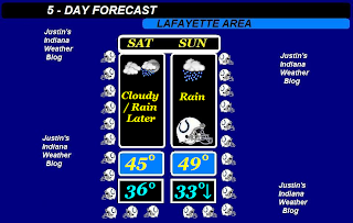
Temperatures are going to be in the middle 20s to low 30s pretty much all this week into the weekend. This means that any precipitation to fall will fall in the form of snow! I will say that after seeing highs around 49 and 50 degrees yesterday it is pretty odd seeing snow as we woke up. And now were talking about lows falling into the teens. Well, at least mother nature gave you warm weather lovers a small taste of Spring! Mike Prangley, has been talking about the grass getting green as the days continue with morning highs in the 50s. He's just rubbing it in! ;) lol.

Anyway tomorrow we will look for mostly cloudy skies with around a 20% to 30% chance for a few light scattered snow flurries across the area possible. Nothing will add up however I cannot rule it out! Highs again will be in the low 30s with lows falling near the upper teens. The cold is back!
And I know just about everyone in Indiana was watching the AFC Championship yesterday as the Colts took the Win and are heading to Miami!!!! Yes, we made it to Superbowl XLIV. The colts played a great game however Pierre Garcon, and Austin Collie, really gave it their all! They put on a great show with some AMAZING catches and Touchdowns. Manning made some great passes. It's hard to call Pierre Garcon, and Austin Collie, rookies at this point. They have come so far so fast! It's like Peyton Manning, said. "Austin had no rookie look in his eyes" and they played like veterans. The whole team did a good job. We can't give it all the the Offence, Because the Defense played just as big of a part in stopping the Jets. You have so many key players on "D" it's hard to name them all. Players such as Gary Brackett, Dwight Freeney, Robert Mathis, Kelvin Hayden, Antoine Bethea, Clint Session, Melvin Bullitt, Eric Foster, And many many more! The Colts have such a strong Defense it's hard to get anything going to move the ball down the field. The Colts do a great job in feeling out the team they play through out the first quarter or first half. Then they come out firing and making some big plays. The offence coordinator started calling some plays for Manning to run however Manning started getting hot and call some audible at the line. Manning has always been good at seeing things others may not when it comes to changing up the plays at the line. The Colts have a way of pulling together and making plays when it counts. That's what they have always done and IT WORKS! GO COLTS!
I was also real happy for Pierre Garcon, as you see above. His family is from Haiti, so this win means a lot of him and his folks. Last game VS the Ravens Pierre, still had no word on some of his friends or cousins after the earthquake. However the good news now is everyone is counted for! He has been playing with a heavy hart and you know this win was not only for Indianapolis but also for Haiti, and his family!
So now we go on to play the Saints. I have to say that I was pulling for the Vikings and I give A LOT of credit to Brett Farve! He got hit over 16 times and still stayed in the game. He got hit in the jaw, He got hit in the ribs, And then got hit below the knee which took him out of the game long enough for the defense to take over. They
re-taped his ankle and he wanted back in the game! He is a tough payer and I respect him for that. The saints defense was playing ruff that's for sure. But Farve didn't get sacked once. He had over 16 hits but "no sacks". My hats off to the Vikings.

The Saints played to win and they're going to their first Superbowl which is good for the state. Lets just hope this isn't the Saints year to come away with a win. ;)

GO COLTS!

I'll check back soon..........

Saturday, January 23, 2010

Weekend Outlook. The Cold Returns By Monday!

Well, the weather pattern has been a little out of whack the past few days! With temperatures above average and rain instead of snow. Well, I'm here to tell you all that this is about to change once again. However not before we see some more rainfall in our forecast.

Yesterdays high was 38° degrees. And our average highs is only around 33° degrees. This means we were a good 5° degrees above our average high. Now our lows have been running around 33° degrees which is the average high for this time of year. The average low is around 17° degrees. So we have been running a good 16° degrees above our average low. We need to get things back in order. The more things get pulled out of whack the harder they snap back. And that could be the case starting next week temperature - wise. Just take a look at this map I have put together for you below.
As you can see we will look for the middle 40s to set in over the next few days. Then starting Monday we will start to see temperatures fall back around normal to slightly below average. By late next week we could be looking for highs in the upper teens with lows falling around 10° degrees possible! However this is looking into late next week.

Also we will be seeing some more rain enter the forecast before some snow to start the work week. Yes, rain is on the way starting later on this evening into Sunday. Today I don't look for an all day rain as it would start later on this evening however Sunday will be a wet one for much of the day. So between This evening and Sunday I look for rainfall between a half inch and three quarters of an inch possible. The rain could be heavy at times so a few locally higher amounts are possible in areas. Now lets take a look at the Weekend forecast below.
Yes, the weather watchers will be watching some rainfall as we get ready to cheer on the Colts in the AFC Championship and also to the Superbowl!! It's a good thing we have a dome in Indianapolis so the game won't be a wash out! However I really don't think fans would mind a bit lol. I know I would be out there in the rain cheering them on! I look for highs to be in the middle to upper 40s on Sunday for the game along with some scattered rain showers. Lows will be in the lower 30s and falling! Yes, it will be cold! Then heading into the work week we may see some of this scattered rain change over to some scattered snow showers. However I don't look for it to add up to much.

So good bye rain and we will welcome the snow and cold back with open arms!! :D Well, some more then others as I know a lot of you would like Spring already ;)

Anyway, Stay warm starting Monday and also stay dry! Enjoy your weekend and I'll check back soon...

GO COLTS!!

Friday, January 22, 2010

Developing Weekend Update!

I have your weekend update coming here soon later on tonight. We need to get the forecast ready, Put together some maps, and then start posting! Also the AFC championship is coming up on Sunday! Yes, the Colts VS the Jets. And I'm going COLTS ALL THE WAY!

Stay tuned and I'll check back soon..........

Thursday, January 21, 2010

Icy Update!

Things have been icy to start and it is dangerous. My dogs have been sliding all over the place as well as some cars! As for how much ice have we seen? Well, we got what was call for. Right around 0.02" inches of ice. No this is not much at all however it is enough to make things slick. And also to hear the trees crackle whenever the wind blows. This is how things look outside pretty much all over at this time below.
Now some of the sidewalks are still slick at this time so if your out walking be extra careful. Most roads are in good shape however some side roads earlier this morning was still a little slick. But as the day continues and our temperatures continue to rise very slowly things will start to look better.
We do still have some freezing rain advisories out for counties such as Tippecanoe, Clinton, Fountain, warren, montgomery, carroll counties from now until noon EST today.

So please continue to stay safe and be careful! This is what we call for so now you all need to do your part to be safe and stay safe!

I'll check back again soon..........

Wednesday, January 20, 2010

Total Snowfall Up To This Point! And A Look At The Before And After!!

Well, bloggers how have things been? We have a lot of weather to talk about today that's for sure! We have rain on the way with a little freezing rain possible! But the good news about the freezing rain is I don't look for much. I really don't see anything over a tenth inch in the way of ice. But before that I wanted to talk about something else first! Spring is coming up believe it or not on March 20th. So I thought we would go ahead and take a quick look at how much snowfall I have recorded here in Lafayette, up to this point. Brow, sends in this picture below from our last six inch snowfall we seen on January 7th.
Alright lets take a look at the average yearly snowfall total for the WLFI viewing area. Average yearly snowfall total around 26.2" inches. Our current yearly snowfall total is around 12.76" inches. This means we are still a good 13" to 14" inches below our average yearly total. However there is still a lot of winter left! But with all these above freezing temperatures it's been hard to get any snow. I mean we are about to track some rain / freezing rain later on tonight into tomorrow! Crazy! groundhog day is also coming up on the 2nd. Do you think we will see six more weeks of winter? I sure hope so! We need to catch up on our total. :)
.
Quick Cast................................................
.
Thursday we will see some light rainfall move into the WLFI viewing area along with some light freezing rain possible. Now some of the WLFI viewing area counties are under a winter weather advisory. Here are the current counties. Warren, Fountain, Montgomery, Benton, Newton, and Jasper counties. This has been put into effect because of the threat of some freezing rain. Good news is I look for this to be a mostly rain event. So ice accumulation will be on the light side. Less then a tenth inch. Rainfall will also be rather light between a quarter and "Maybe" a half inch. Highs will be in the upper 30s to low 40s. Lows will be in the low 30s. Winds between 10 and 15 mph gusting between 20 and 25 mph possible.
.
Friday we may start out with some really light hit and miss scattered showers in the early morning however I'm not seeing it last all day! So rainfall will be less then a tenth inch. We will see mostly cloudy to partly cloudy skies by that evening. Highs will be in the upper 30s with lows in the upper 20s to low 30s. Winds will be between 5 and 10 mph with gusts to 15 mph possible!
.
Now as for when will the cooler temperatures try and make a comeback? Well at this time it's looking like we may start to get back to around average which is the lower 30s by sometime next week. With more chances at mixed precipitation by the late weekend. Yes, it could be a nasty start to the work week. And by nasty I mean wet! I'll keep you posted. I'm looking forward to the cold weather returning next week! :)
.
Now as you all know we have been doing lots of home improvement this whole month. Well yesterday we pretty much finished up the Kitchen. There are still a few things that need to be done however I think the worst is over. I do have some before and after pictures to show you all below. This is the counter tops we put on yesterday. It was a pain in the Butt however it looks really nice! Take a look below.
In this picture above if you look you can see the floor I put in. I love that wood look. Also the new doors under the sink. It's really coming along.This above is where we boxed in the top for extra space. Then added a border. This came out better then I first thought. Now below is a look at some of what we have done in the front room. Sorry I don't have any before pictures. But the after looks better anyway! lol :)I have to say this is one of my favorite parts. Yes, the fireplace. All repainted and looks even better in person!Also one of our favorite walls. Can you really have a favorite wall? lol :)
And last but not least.....
.
We still need to get new carpet and a few other things however it is really coming along. And as you all can see we really have been busy. But we are making great time. I hope you all enjoyed this look into my new better looking home.
.
I'll check back again soon..........

Tuesday, January 19, 2010

A Foggy Start To The Day With Rain Possible Wednesday Evening...

Well, we had a little light fog pretty much through out the whole day yesterday and today we could have much of the same! With our Temperatures and Dew Point Temperatures being really close together there is a good possibility of seeing some thicker fog this morning. So heading out to work and school could be tricky! You will need to take it also and allow extra time as always!
Fog driving safety tips...
The best advice we can give to drivers confronted with thick fog is to get off the road as soon as possible. If you can't or won't pull off the road we offer the following advice:

Keep your minimum safety gap to three seconds in ideal conditions; with the decreased visibility fog causes, this interval should be increased substantially.

Slow down. Most fog-related traffic fatalities occur because someone was driving too fast and couldn't stop in time to avoid a collision.

Make sure that you can be seen. Turn on your fog lights, and use low beams. High beams direct light up into the fog making it difficult for you to see. Low beams direct light down onto the road and help other drivers to see you.

If you leave the road, be sure to pull off completely. Turn off your driving lights and turn on your flashers so others know you're there but won't think you are driving on the road.

Always use your defroster and windscreen wipers in foggy conditions to keep the windows clear.
Keep an eye on your speedometer and maintain a slow, constant speed.


Remember that other drivers have a limited sight distance and that fog can leave roadways slick. Signal early, and when you use your brakes, don't stomp on them.

Now for today other then the fog we should look pretty good. Right now I'm not seeing any rain until later on tomorrow evening / night. And this is why below.
As you can see in this image above we have been seeing this stationary front to our south. This stationary front as all stationary fronts do, is moving very slow across the area. This means that closer to Wednesday evening / night this rain you see to the south and east of Indiana will have a chance to move through. This image above is for Wednesday morning.

Quick Cast..................................

Today we will look for some mostly cloudy to partly cloudy skies after the foggy start to the day. We will see highs again in the upper 30s to low 40s possible with lows dropping tonight into the upper 20s. Winds will be really light between 3 and 5 mph.

Wednesday we will start out with mostly cloudy skies. However as we continue through out the day we will see more clouds try to move in. Along with rain that evening / night do to the stationary front to our south. Highs will be in the middle 30s with lows in the low 30s. Winds will be between 5 and 10 mph.

~~~~~~~~~~~~~~~~~~~~~~~~~~~~~~~~~~

It's looking like the temperatures we are currently seeing will stick around into next week! Booooooooo :) lol as you can tell I would rather have the 20s back as our highs! Our average high for this time of year is around 31 to 33 degrees so really were not far from that. Which is pretty good I guess. However the average low for this time of year is around 16 to 17 degrees! And that we have been far from. As our lows the past few nights have been around 28 degrees. This is a good 11 degrees above average! So we need some work on our low temperatures. ;)

I have still been real busy with home improvement however I'm trying to make time for the blog. I have taken some pictures and I will try to post them here real soon. Also with temperatures being around 31 degrees at 3:00pm yesterday I was able to get outside and work out a little in my free time. Sure it was cold but we gotta stay in shape right? lol.

Stay safe bloggers. I'll blog at you again soon.

Thanks for reading!

Monday, January 18, 2010

Updates About To Start Up Again...

Hey bloggers. I know it's been a few days from my last post but I have again been real busy! Things are slowly getting back to normal so I will have more updates starting up once again. First today I have to go do some work for my neighbor then I will be back here later on with your work week update! We will find out when we will take another cold drop in temperatures! And also if we have any more heavy precipitation to talk about! All this and more coming soon.

Be sure to check back! An update is upon you! ;)

Friday, January 15, 2010

I'm Teaming Up With My Sister To Bring You The Latest!

Hey bloggers. Just checking in with you all as I have some extra time. We do have a little weather to talk about this morning however nothing much or anything to get into real weather ready mode lol. But we should still have a little fun! Just take a look at this image I have put together for you all below. This pretty much tells the story.
You can see we have a slim change for some light drizzle or light rain early this morning. So if your heading out to school or work you may see a little bit of what's in this image above. The good news is it is only a 20% chance or less. So even if this falls as freezing drizzle it won't add up to anything and shouldn't be a big problem. And that is GREAT news for everyone. This is all forming off this small cold front. We have been seeing temperatures in the upper 30s however yesterday we hit a high of 43.7 degrees!! WOW that felt like a heat wave! lol :) And we could see more of this kind of temperatures over the next day or so. This cold front won't cool us off to much. However after the weekend we can look for temperatures to try and drop back into the low 30s as our highs. I know my sister will be happy to hear that as well as I'am. We go crazy over the cold weather! ;)

Quick Cast........................................

Today we will look for some light morning drizzle. This is only around a 15% to 20% chance and I don't look for much at all. We will then try and become more mostly cloudy to partly cloudy as the day continues. Highs will be in the upper 30s to low 40s once again. With lows falling to the upper 20s to low 30s. Winds will be light once again between 2 and 5 mph.

Saturday the start of the weekend and also the day the Colts play!! We will see some nice partly cloudy skies over the WLFI viewing area. Highs will be in the low 40s to middle 40s. With lows falling in the upper 20s to low 30s. Wind swill be light between 3 and 5 mph. Just a nice start to the weekend!
~~~~~~~~~~~~~~~~~~~~~~~~~~
~~~~~~~~~~~~~~~~~~~~~~~~~~~~~~~~~
As you can see things are looking pretty good at this time weather - wise! However in other parts of the world things are totally different! Yes, you can bet I'm talking about Haiti. This major earthquake took these poor people by surprise! This is a scary event without a doubt! This earthquake was a 7.0 on the scale's! WOW. You all remember that small earthquake that we had last year? Well, that's nothing as to what they have gone through! I pray for those people! God Bless..........

Now my sister CJ, has always been into big weather events such as this! So she has done her research and I have asked her to come on here and say a little about it. I will ask a few questions and she will answer. Let's get to it below.
What makes this 7.0 earthquake stand out from say an 8.0 or a 9.0 in other areas?
The fact that the buildings weren't built to withstand an earthquake like in California. And that this earthquake was only 6 miles below the surface as opposed to one that is 200 miles below the surface. The difference is that with one 200 miles below it would not have been as damaging because of cushioning, with this one being only 6 miles it didn't have as much so it caused more damage.

Where did this earthquake originate from, and how long did it last?
Around Port-Au-Prince, and I believe it lasted for around 35 seconds.

What are Americans and others doing to help the people of Haiti?
We are sending the supplies that are needed at this moment along with the U.K, like food, water and medical. We are also sending troops to help with search and recovery. We are also sending in the machinery needed to move rubble, on Saturday there will be a ship sent with a built in hospital and burn unit along with much more. Scotland has also sent a K9 unit to help find victims that are still trapped.

Your thoughts on this terrifying event.
It is a very devastating blow to Haiti which had very little to work with before hand. I mean they were still trying to recover from three hurricanes that slammed into them in 2008, these people have nothing left, there whole country has pretty much been destroyed, I couldn't even imagine being there in their position now still felling the earth shake because of aftershocks that are 5.0 and a little above. Haiti was a very poor country to begin with so rebuilding could be a problem even with the support they are receiving. Haiti was much like any other country before any of this happened just trying to take one day at a time and now their world has been turned upside down in 35 seconds, so you can imagine how scared and terrified they must be.
My thoughts, prayers and heart go out to them.

~~~~~~~~~~~~~~~~~~~~~~~
~~~~~~~~~~~~~~~~~~~~~~~~~~~~~~
I want to thank my Sister CJ, for coming on here and giving us her thoughts on this situation. I will have to have her team up with JIWB more often! ;) I do pray for those people and wish them a fast recovery! I want everyone here to pray for them. This has been a huge event and they need all the help they can get!

Thank You!

Posted by CJ, and Justin.

Wednesday, January 13, 2010

No Big Systems To Track This Week!

So much has been going on but you bloggers have been great! I know I haven't been updating as much as I usually do. However I'm doing the best I can. The good news is I did have enough time to put together a little something today and we will have a nice break from any heavy weather tracking! This will help me out as well. I know I can't be in two places at once so Nature is giving me time to get some more home fix ups done! lol :)

To answer Barb's, question about "Before" and "after" pictures. Well, I don't have "before" pictures lol, but I will try and take some pictures here and there of what we have done coming soon. I have to say that I'm most proud of the kitchen floor. And that's because I got the floor, And I laid the floor myself. This isn't the first time I have done this however this is by far the BEST it has ever looked. I still have doors to put on the kitchen cabinet's, and carpet in the front room to get done. However things are looking good and really coming along. My parakeet Memo, really isn't making things any easier! lol right after I finish whatever it is I'm doing in one of the front rooms I then head back to my room at the end of the day to find a mess EVERYWHERE!!!! And I mean all over! I don't know what they get into but whatever it is they sure do have a fun time with it! :) Oh well...

Now real quick lets take a look at the next few days ahead.

Thursday we will look for mostly to partly cloudy skies. However I have to keep around a slight 15 to 20% chance for a light drizzle come Thursday night into early early Friday moring. Nothing much however I cannot rule it out just yet. We are looking for warmer weather to start moving into the area :( We will look for highs in the middle 30s with lows in the upper 20s. Winds will be between 10 and 15 mph with a few gusts to 20 mph possible at times.

Friday we will see Mostly cloudy skies for the most part with a few breaks in the clouds possible later on in the day. However like I said above I cannot rule out around a 15% chance of some light drizzle in the early morning hours. Again nothing adding up to much at all. Highs will be in the low to middle 30s once again with lows in the upper 20s to low low 30s. Winds will be really calm between 2 and 5 mph.~~~~~~~~~~~~~~~~~~~~~~~~~~~~~~

This means that we will start to see our snowfall slowly start to melt over time. You better go take some pictures of any snowmen you may have made! Who knows how much longer we should have them.....Lol I love that picture :D Ha Ha..... As you can see it doesn't take much to make me laugh! :) lol.


Man there is just so much stuff going on. However one really fun thing going on is the playoffs! Yes, football is one of my favorite things of all time! And even more I have my two favorite teams still in the playoffs. AZ, and IND!! I have made sure that even when I was laying the floor I had a small TV on with the AZ, game lol. I just cannot miss a football game. I don't know why? I just know I can't lol :) And the Colts, play Baltimore, on Saturday. GO COLTS! Whose with me??


Oh and one more thing I wanted to show you all before I get off here. I found this on one of the sites I follow and I thought you all would really enjoy it! Take a look below. This brings a whole new meaning to the words "Sun Flower".

SUN FLOWER: For the past week, much of the northern hemisphere has been in the grip of paralyzing cold. Some people say it's a hardship. Holly Miller-Pollack prefers to think of it as a photo op: "This morning, everything was covered in frost so I went out to take a few pictures," she says. "This one came out looking like a sunflower."

"Also, look just above the sun," she points out. "The clouds are shining with iridescent colors." That is a result of the cold, too. Tiny ice crystals in the cloud diffract sunlight to produce the pastel hues.

Ice in the air. Ice on the ground. Add a dash of sunlight and voila!--a lovely snapshot.

Now remember for the rest of the week we will slowly start to warm up a little bit each day. And I'm not seeing any real big systems to track this week. So stay warm stay safe and again I will try and pop back in soon...
Thanks for reading..........

Tuesday, January 12, 2010

It's Been A Crazy Week!

Thank you everyone for worrying about me however everything is just fine. I have been busy from morning til night working inside on home repairs. We have painted just about everything you can think of. I was laying floors in the kitchen a few days ago. Then more painting. Now starting tomorrow or so we will be putting in new cabinet doors. then in a few weeks we will continue to fix up the front room and kitchen here and there. It's work in progress....

I will try to post more weather updates here soon. It has just been so crazy this week that's for sure.

So stay tuned and stay cool!
Developing......................

Friday, January 8, 2010

Snowfall Numbers!

Let's check out some the snowfall totals from our big snow storm.

Logansport, comes in with another 4.0" inches. Making the New and Old snowfall final total 8.0" inches.

Remington, comes in with another 4.0" inches. Making the New and Old snowfall
final total 7.0" inches.

Lafayette, comes in with 6.2" inches. Making the New and Old snowfall final total 7.0" inches.

Attica, comes in with 3.0" inches. Making the New and Old snowfall final total 7.0" inches.

Kentland, comes in with 1.0" inches. Making the New and Old snowfall total 5.0" inches.
~~~~~~~~~~~~~~~~~~~~~~~~~~~
~~~~~~~~~~~~~~~~~~~~~~~~~~~~~~


We still have some cold weather moving into the WLFI viewing area for the next few days! However even after the weekend we will still be talking about cold temperatures. But they will be above zero! lol. As we head into Saturday we will see temperatures in the daytime only around 12 degrees or so. Lows will fall below zero around -2 degrees. And even on Sunday we will still feel cold. We will look for highs around 18 degrees with lows falling into the single digits once again around 8 degrees.

Bottom line! It will be cold..... So stay warm with lots of Coffee, Cocoa, ect, and stay safe! Have a nice weekend and watch the roads!

I'll check back again soon..........

Thursday, January 7, 2010

Blogger "Q" And "A" ;)

Special Blogger "Q" And "A" Update...

Anonymous said...
Hey Justin, Its still snowing out here in the Mulberry- Dayton area and on the radar it shows nothing. Can you tell me why?
January 7, 2010 9:34 PM


Well, Anonymous, this is a good question! And I think I can answer it! Believe it or not many radars that most people use sometime don't pick up some precipitation. In this case the snow precipitation was really light! So using some national radars such as Intellicast, or accuweather, ect, it doesn't always show up! That or most radars will pick it up as ground clutter or a light mist. Take a look at this image below.
This radar image was taken around the time you posted your question. As you can see my radar did in fact pick up some really light precipitation over the Clinton, county / mulberry, area. It is in fact showing up extremely light! however it's still there. And also when we have snow like what we have now and by that I mean a really "Light Fluffy Snow" these 10 to 15 mph winds we have been seeing tend to blow it around and can make it look like its snowing heavy at times! All these factors come into play. But my guess as to why you didn't see snow on the radars is because of the type of radar you were viewing, and also that the precipitation was to light for most radars to pick up! :)

Thank you for your question! And I hope this helps! ;)

The Latest Update On What's Going On And What's Still To Come!! Cold Polar Temperatures And Another 1" Of Snow Possible!

Oak, things have calmed down snowy - wise. However as for winter safety that's another story! Things are still tricky when it comes to that! Everyone still needs to take it slow on the roads or better yet just stay home if possible! I say this for many reasons however the most important one would have to be "Your Life". Just take a look at this picture my aunt sent me below.This picture was taken at 52 and union. You can see the roads are still a mess at this time. totally snow covered! This is why the county travel status is at a level 3 in Tippecanoe with talk about a level 2 warning! Remember that Warren, county is now under a level 2 Warning. And Fountain, county is still under a level 2 Warning as well. And just a few minutes ago Clinton county was put under a level 3 watch! So it is best to stay home if at all possible! Again here are the meaning of both the level 2 and level 3 below.

LEVEL 3 WATCH.This means that routine travel or activities may be restricted in areas because of a hazardous situation.You should use caution or try to stay home if possible!

LEVEL 2 WARNING. This means that conditions are treating to the safety of the public. Only essential travel is recommended. As in to and from work / Emergency situations ect... Emergency action plains have been or should be implemented by businesses, schools, government agencies, and other organizations..
~~~~~~~~~~~~~~~~~~~~~~~~~~~~~~~~~~
~~~~~~~~~~~~~~~~~~~~~~~~~~~~~~~~~~~~


Now lets take a look at the total snowfall at this point and time below.As you can see between both the old and new snowfall we have a ground total of 4.50" inches. However we picked up a good 4.00" inches today alone for this huge system that is pushing through. And we are still look for another 1" inch possible by Friday. This will be from the snow that is to our north on the back side of this system. You can see what I'm talking about in this image below.You see all the blues to the east of our great state. This is what has pushed through earlier this morning though the afternoon hours. Now because of the counter clockwise flow of the low pressure system we will see the snow to our north start to push through giving us another change a at light inch possible by tomorrow. however snow is not the only thing we will see! Yes, the winds are going to start to pick up between now and 6:00pm EST this evening. We will see winds between 5 and 10 mph however they could gust between 15 and 20 mph without any problem. This will be a threat with the roads as this snow is so light it will blow and drift over roads like crazy! So driving in the evening hours will be dangerous and tricky! Again drive SLOW or Stay HOME if you can... Also COLD polar air is really going to set in and take over for the next few days. Take a look at this map below.That's right the Indiana area is going to feel FRIGID for a little while. Tomorrow / Friday we are going to see highs around 14 degrees with lows dropping into the single digits. Yes, around 8 degrees possible! Now with winds blowing around 10 to 15 mph this will make our daytime high feel around 3 degrees. However our nightly low will feel around -4 to -6 degrees! Brrrrrrrrrrrrrrrrrrr Is the word of the day! Be sure to take an extra blanket to bed and keep your pets warm as well. Just like you and me they to get cold!

Now here are the current winter storm warnings as well as the winter weather advisories below. Stay safe Bloggers and stay warm. I will check back soon with more and final snowfall totals from around the WLFI viewing area later on... It's still snowing and we will continue to add it up til the last flake falls! ;)

Winter Weather Advisory

CARROLL-WARREN-TIPPECANOE-CLINTON-HOWARD-FOUNTAIN-MONTGOMERY-
VERMILLION-PARKE-
INCLUDING THE CITIES OF...LAFAYETTE...FRANKFORT...KOKOMO...
CRAWFORDSVILLE

...WINTER WEATHER ADVISORY REMAINS IN EFFECT UNTIL 7 AM EST
FRIDAY...

...WINTER STORM WARNING IS CANCELLED...

~~~~~~~~~~~~~~~~~~~~~~
~~~~~~~~~~~~~~~~~~~~~~~~~~~~


Winter Storm Warning

Benton, Newton, Jasper Counties.

...WINTER STORM WARNING REMAINS IN EFFECT UNTIL 9 AM CST /10 AM
EST/ FRIDAY...

Watch Into Effect!

For TIPPECANOE County there is a LEVEL 3 WATCH for Our area. This means that routine travel or activities may be restricted in areas because of a hazardous situation.You should use caution or try to stay home if possible!

Snow Covered Roads!

I got a few pictures sent in to me from my Aunt. These are just some of what areas of US-52 look like at this time. She took these pictures around five minutes ago. These roads are just still so snow covered and slick it's not even funny.
If you guy's can stay off the roads that would be the best possible thing you can do! All you need to do to say safe while out (IF) you have to go out is S-L-O-W DOWN!!!! Slow down, slow down, slow down!!!! You do not need to drive fast in this kind of weather! If your out in your car just (Take your time) Please! To many people have been hurt already today from driving to fast in this weather! Know the dangers and be ready, and Smart!
I'll check back soon with more updates as needed..........

Crashes Close Parts Of I-65...

Crashes close parts of I-65

FRANKFORT, Ind. (WLFI) - Indiana State Police said that part of I-65 is closed in both directions due to crashes.


As of 11:15 a.m. I-65 southbound lanes are closed near the Frankfort SR 28 exit (about the 150 mile marker) in Clinton County.

Northbound lanes are closed near Lebanon in Boone County.

No word on when they might open.
~~~~~~~~~~~~~~~~~~~~~~~~~~~~~~~~

This is why people need to be aware of the dangers of winter driving! Let's all hope that everyone is oak and now safe!

Lafayette, has three inches of snow at this time. I still like my calling for between 2" and 5" inches. Right now we are right around the middle of that range. Things are still looking good.

Brow, we look forward to some snowy pictures! ;) Get home safe!

Update As Of 10:53AM EST.......... The Snow Is Coming Down!!

You can pick put the snowflakes in this image above which means that they are twice the size in this picture. It is just going down like crazy out there here in the Lafayette, area. Quarter size flakes is the bast way to say it. When you look way down the street you see nothing but white. Take a look in this image below.It's just amazing. This is the kind of weather I love the most. As long as everyone know the dangers and does their part to stay safe! The roads are still snow covered and slick at this time. So if you can stay home that would be best! However we know a lot of people cannot do so. So there are a few tips above to keep in mind while out in this snowy slick stuff.
.
Winds will pick up later on this evening closer to 6:00pm and 7:00pm EST. Gusts will be around 15 and 20 mph possible. This is when snow will start blowing around and things could get tricky!
.
Here are your warnings posted below as well as the County Watch and Warning.
Stay tuned bloggers. I'll check back as needed..........
Thank you for your Comment! KEEP THEM COMING!

The only two counties not in this warning are White, and Cass, counties. Every other WLFI viewing county is under this warning from now through 6:00pm EST tonight.

PRECAUTIONARY/PREPAREDNESS ACTIONS...
A WINTER STORM WARNING FOR HEAVY SNOW MEANS SEVERE WINTER WEATHERCONDITIONS ARE EXPECTED OR OCCURRING. SIGNIFICANT AMOUNTS OF SNOWARE FORECAST THAT WILL MAKE TRAVEL DANGEROUS. ONLY TRAVEL IN ANEMERGENCY. IF YOU MUST TRAVEL...KEEP AN EXTRA FLASHLIGHT...FOOD...AND WATER IN YOUR VEHICLE IN CASE OF AN EMERGENCY.

For Warren County there is a LEVEL 3 WATCH for your area. This means that routine travel or activities may be restricted in areas because of a hazardous situation.You should use caution or try to stay home if possible!

Fountain county you have a LEVEL 2 WARNING into effect for your area! This means that conditions are treating to the safety of the public. Only essential travel is recommended. As in to and from work / Emergency situations ect... Emergency action plains have been or should be implemented by businesses, schools, government agencies, and other organizations..

UPDATE!!

We have a winter storm warning just issued for all of the WLFI viewing area. The only two counties not in this warning are White, and Cass, counties. Every other WLFI viewing county is under this warning from now through 6:00pm EST tonight.

PRECAUTIONARY/PREPAREDNESS ACTIONS...
A WINTER STORM WARNING FOR HEAVY SNOW MEANS SEVERE WINTER WEATHER
CONDITIONS ARE EXPECTED OR OCCURRING. SIGNIFICANT AMOUNTS OF SNOW
ARE FORECAST THAT WILL MAKE TRAVEL DANGEROUS. ONLY TRAVEL IN AN
EMERGENCY. IF YOU MUST TRAVEL...KEEP AN EXTRA FLASHLIGHT...
FOOD...AND WATER IN YOUR VEHICLE IN CASE OF AN EMERGENCY.

~~~~~~~~~~~~~~~~~~~~~~~~~~~~~~~~~~~~~~~~

Lafayette, is currently up to two and a quarter inches of snow. 2.25" inches. Now counting what was still frozen to the ground yesterday before we started adding today that brings us to 3.50" inches on the ground at this time. Remember that is counting both old and new snow.

Image above taken at 10:00am EST.....

You can see in this image above all the different colors of blue really moving into the area. One band really stands out to me at this time. As you can see in the left of this image. This is a band currently moving through Fountain county Warren county, and Benton county, about to move into Tippecanoe, and White, counties. This band is looking like snow fall at a rate of an inch an hour! It's going to get heavy for a little bit here soon bloggers. The Winds are blowing around 5 to 10 mph so this snow will be like Annie, said earlier "Blowing In Your Face"

Please be safe while out! And be alert of the dangers of this weather!

For Warren County there is a LEVEL 3 WATCH for your area. This means that routine travel or activities may be restricted in areas because of a hazardous situation.You should use caution or try to stay home if possible!

Fountain county you have a LEVEL 2 WARNING into effect for your area! This means that conditions are treating to the safety of the public. Only essential travel is recommended. As in to and from work / Emergency situations ect... Emergency action plains have been or should be implemented by businesses, schools, government agencies, and other organizations..

STAY SAFE BLOGGERS! I'll Check back as needed.....

Wednesday, January 6, 2010

Storm Update! Things Are Still Looking On Track!!

Weatherman 1 I have gone through the latest data once again and at this time I can say that I'm still feeling good with calling for my 2" to 5" inches of snow over Thursday. With another inch to maybe two inches possible on Friday. Which would bring our final total between both Thursday and Friday between 3" and 6" inches with a few locally higher amounts near 7" inches in spots cannot be ruled out. You can see the snow moving in closer in this image below.Radar image taken at 8:13pm EST..........

We do have many watches, warnings, and Advisories out with this storm. All the counties in the WLFI viewing area are currently under that Winter weather advisory. This advisory is in effect from 4:00am EST Thursday through 7:00am EST Friday. The only counties that are not in the Winter Weather Advisory are Newton, Benton, and Jasper counties, However they are currently under a Winter Storm Warning. And this is in effect from Midnight tonight through 6:00pm CST Thursday. So stay storm ready and be S-A-F-E!! ;)

We will see winds blowing between 10 and 15 mph on Thursday into Friday afternoon. And believe me that this is enough to whip this snow all over the place! This is going to be a light fluffy snow as I have said the past few days. We will see the winds start to pick up be Friday evening to around 20 mph possible. It will be VERY cold the next few days so remember the Hot Cocoa Advisory!


Main Storm Threats:

Heavy Snow During Rush Hour: Snow will be at it's heaviest in the morning around 6:00am and 7:00am so driving to work will be a challenge. Please allow yourself some extra time to get from point "A" to point "B". Drive slow and remember your winter driving safety tips.

Slick Roads: Roads will be very slick as our temperatures are cold enough that the ground is nice and hard. So anything to fall will have no trouble sticking.

Blowing And Drifting Snow: Blowing and drifting snow will be a threat even with only 10 to 15 mph winds. When we have snow this light and fluffy it will have no trouble blowing around like a light dust.
~~~~~~~~~~~~~~~~~~~~~~~~~~~~~~
~~~~~~~~~~~~~~~~~~~~~~~~~~~~~~~~
~~~~~~~~~~~~~~~~~~~~~~~~~~~~~~~~~~

Here is the meaning of the Winter weather Warnings and Advisories above.

Winter Weather Advisory: Issued for a hazardous combination of snow, and ice of which neither meets or exceeds warning criteria. Issued for winter weather that will cause significant inconveniences or could be life-threatening if the proper precautions are not taken.

Winter Storm Warning: Issued for a combination of heavy snow and/or ice, of which, at least one exceeds or meets warning criteria. Winter weather is expected to cause life-threatening public impact for a combination of winter hazards including heavy snow, ice, near blizzard conditions, blowing and drifting snow and/or dangerous wind chills.
~~~~~~~~~~~~~~~~~~~~~~~~~~~~
~~~~~~~~~~~~~~~~~~~~~~~~~~~~~~~~~


Stay safe bloggers and please be storm ready. We will see HEAVY snowfall in the morning hours and the afternoon.

I'll check back soon..........

Watches, Warnings And Advisories In EFFECT!!

WINTER STORM WARNING IN EFFECT FOR THE FOLLOWING WLFI VIEWING AREA COUNTIES..........

Benton, Newton, Jasper.

This warning is in effect from 9:00pm tonight through 6:00am CST Friday.
~~~~~~~~~~~~~~~~~~~~~~~~~~~~~~~~~~

WINTER STORM WATCH IS IN EFFECT FOR THE FOLLOWING WLFI VIEWING AREA COUNTIES..........

Tippecanoe, Warren, Carroll, Clinton, Fountain, Montgomery.

This watch is in effect from late tonight through Friday Morning.
~~~~~~~~~~~~~~~~~~~~~~~~~~~~~~~~~~

WINTER WEATHER ADVISORY IS IN EFFECT FOR THE FOLLOWING WLFI VIEWING AREA COUNTIES..........

White, Cass.

This advisory is in effect from 1:00am Thursday through 7:00am EST Friday.

Winter Storm Watches In The WLFI Viewing Area. Blizzard Warnings To Our West!

I have been right here in the weather mode all morning going through the latest weather data! Right now I still want to call for my 2" to 5" inches. With another 1" to 2" inches possible on Friday due to what will be on the back side of this system. This would make our snowfall total between Thursday and Friday between 3" and 6" inches possible. So 2" to 5" inches possible starting late late tonight after 1:00am or 2:00am EST and then the other possible inch or so on Friday. You can see this snow system really starting to develop to our west in this radar image below.
Image taken at 11:50am EST..........

There is some blizzard Warnings in the SD, areas, Now I don't see us getting a blizzard but still I had to let you know! ;) Still we will have to worry about some blowing and drifting snow! We are still under that winter storm watch from tonight until Friday morning. Yes, the WHOLE WLFI viewing area is under this watch! So please stay tuned to JIWB for more updates as this system continues to develop and moves closer to our great state.

So once again I want to break down what I'm calling for at this time. I look for snow showers to start after 1:00am or 2:00am EST tonight. Snow showers will go through out Thursday into Friday. Expected snowfall for Thursday looks between 2" and 5" inches possible. Then another inch or two can be expected on Friday. So the grand total between both Thursday and Friday is looking between 3" and 6" inches with a ((few local areas)) picking up a little closer to seven inches (possible). And remember that the 2" to 5" inch range is just a range. This does not mean we will see 5" inches. This just means any where between 2" and 5" inches. As well as the grand total of 3" to 6" inches with locally higher amounts near seven inches possible. I know many of you already know this however there are some that will bust my butt lol :) ;) Ha Ha.....

Stay tuned I'll check back again later on with another last look at this system before it comes across the state line!

Storm Threats Will Be:

Heavy snow during morning rush hour: As well as the daytime hours in the afternoon. Please drive careful while out!

Slick roads: Due to the cold temperatures we have been seeing snow will stick to the roads with out a problem.

Blowing and Drifting: Blowing and drifting snow will be a problem as this snow will fall as a light fluffy snow. Even 10 to 15 mph winds will blow this snow all over!

REMEMBER YOUR WINTER DRIVING SAFETY TIPS AND STAY SAFE!!!

We Are About To Walk In A Winter Wonderland! :)

SnowstormFrosty We have a lot of winter weather ahead of us that's for sure! We are talking about COLD temperatures and some SNOWY weather moving into the WLFI viewing area here real soon. Well, the temperatures have been here for a while however we could see them get a little cooler by Friday! Still for this whole week I DON'T see temperatures getting out of the 20s for highs. I'm putting a Hot Cocoa Advisory into effect now through the weekend! So stock up! :)

Now on another note we do have a real time Winter Storm Watch into effect from Late tonight through Friday morning. And this is because of the low pressure system that is currently looking to dump some significant snowfall in our area. Here's the Winter Storm Watch below...As you see above the main threats will be that this snow is going to be a light fluffy snow due to all these COLD temperatures were seeing. Lows dropping to almost single digits and highs in the teens. Our ground is totally frozen so every snowflake to fall will stick! This will make roads very slick at times and maybe for the morning rush hour, As well as the afternoon. During the Morning rush hour as well as the afternoon is when the heaviest band could try and push through.Now earlier I didn't want to give away any snowfall amounts because this system can change for more or less quickly. And I'm still watching this system closely! I have gone ahead and posted an idea amount above. As you can see I have the 2" to 5" inch range. Now I'm currently looking for 2" to 5" inches however any minor changes in this system will change snowfall totals. I know some are calling for closer to seven inches! I can tell you why they could call for that high of an amount. We will be so cold that this is going to be a really light snow. And right now precipitation models are looking for around 0.25 inches of precipitation near 0.30" inches. Now in snow this would be around 2" to 4" inches depending on how moist and or heavy the snow is. In our case it's really light and fluffy. So if this system takes it's time moving across the area then snowfall totals will go UP from my 2" to 5" to a higher amount. This is what we need to continue to watch. And this is why I will have another update later on this evening. I will stick with 2" to 5" inches for now. And if we need to we can always add to that. Or drop it some. For now I think this is a good starting point!

Now on top of what we get late Wednesday into Thursday we could pick up another inch or so on Friday due to what's left over on the back side.

Right now I'm looking for the heaviest bands to try and push through in the late morning hours and afternoon hours of Thursday as seen above. This map is looking around 1:00pm EST Thursday. The good news for snow lovers is that the weather models are agreeing that we will see a nice snowfall. With at the "least amount" of 1" to 3" inches. However I still want to keep the 2" to 5" inches in play for a while. I will continue to go through the latest weather data and I will check back again this evening once the latest models come in. This way we will have another update before the snow moves in late late tonight into early Thursday. Remember that this snow will be really light and fluffy so any wind will blow it around like crazy! The good news is I'm only seeing winds gusting to 15 mph or so at this time! I'll keep watch on that as well. Because 15 mph is still enough to blow this snow around!

Warm By The FireI'll check back soon. Stay Tuned And Stay Warm!
Now go get some cocoa! :)Hot Chocolate Yummmmmmmmmm!

Tuesday, January 5, 2010

Developing Snow System By Late Wednesday Into Early Thursday!

Well, the home improvement is looking good at this time. We still have a lot of work to do however it sure is coming along! I'm just checking in with you all real quick because we have another snow system developing for closer to Wednesday night into early Thursday morning. This system will move in from our north west however the big question is where will the main snow band set up? and how much could we see?
Well, you can see in this map above where I'm currently thinking this band "may" set up. However also if you notice I have not put on any snowfall totals at this time! Well I will tell you why! This is because I use more then one weather models as everyone does. And one model is showing the system developing and moving in like the map above. However another has this main band breaking up into two bands by the time it gets to our area. This would set one band up to our north and one to our south. And would drop our snowfall totals a bit. So right now this is just to give you an idea as to what's coming and I will check back later on tonight after the newest weather models come in, Then I will let you all know some snowfall totals. ;)

Until then let's just stay warm because we will continue to stay in this COLD POLAR EXPTRESS pattern for a while! Later tonight we will see what the new models have to say..........

Saturday, January 2, 2010

Starting The New Year With Lots Of Home Improvement's! And Nature Starts Us Off To A Great Start For 2010!!!

Happy New Year bloggers!

Sorry but this is going to be a short update! I'm getting to you late because we have started off our new year with lots of Home Improvement. Yes, we have been painting and redoing everything! And this is going to take a while. I still have more work I need to get done today so I had better get ready to go! But before I do I just wanted to pop in with a quick update getting you all ready for the COLD POLAR EXPRESS moving in today through out this whole week! Today we will see highs not reaching 20 degrees. That's right we won't get out of the teens! And lows will be even cooler! Lows will drop to around -2 degrees! We will look for winds to be blowing between 5 and 10 mph with gusts to 15 mph. This will make our daytime high feel around -2 degrees. And this will make our low feel around -17 degrees! With wind chills around -17 degrees this means we will need to be EXTRA careful when out and about! This means FROSTBITE in 30 Minutes or less!!!! Brrrrrrrrrrrrrrrrrrrrrrrrrrrr So please remember to stay covered while outside! This is dangerous..... We will be seeing this cold weather for a while as the polar air looks to stick around for a few days!

And last but not least here are a few pictures from our New Years Party! LOL. We had a wonderful time playing the Wii and watching the Ball drop. Also all the confetti mess!! :) lol take a look below.
Image Above: My Sister and I after the Confetti...Image Above: The BIG Mess LOL...
Image Above: And as always the one and only Dick Clark! You just can't have New Years with out Mr, Clark! :) He is still going strong and counting us into the New Year! He is one of a kind that's for sure!

And I have one more thing to show you all that really tells you that we are on the right track to a GREAT and HAPPY New Year! That's right we was looking for that Blue Moon and thought the clouds would keep us from seeing it. Well, I kept my forecast clear saying that we may see a few quick breaks in the clouds to see this beautiful moon and sure enough we DID!Image Above: The Blue Moon was bright and BEAUTIFUL!! And this is great that we got a chance to see it. Had we not seen it on New Years Eve then we would have had to wait until 2028 before we would have another chance to see it again! So we are VERY lucky! You can see all the clouds in the bottom of the picture above!

Now I need to get ready to start in on the Home Improvement's again today. I will try and check back again soon bloggers. It's going to be VERY busy for a while. Please stick with me and I will try to update again soon. Thank you!

AND HAPPY NEW YEAR 2010!! :D