
Thursday, March 31, 2011
Monday, March 28, 2011
Hissing Geese And Rainbows At Night??? What The??? ;)
Believe it or not today actually turned out to be a nice day weather - wise across the area! Even though Lafayette, only hit a high of 48.1* degrees it seemed to feel warmer then that. Maybe all the sunshine had something to do with that?!?! lol. It created the illusion that it felt warmer because it looked like it should have felt warm! ;)
I even made it out to Armstrong park for a quick run around the pond. I also learned something I never knew lol.

Yes, that's right!! Hissing Geese lol. Did anyone know that geese could hiss?? I never knew this lol. I found out as I came down the hill at a jog and passed some geese. One of them looked over at me and hissed lol. I looked over and couldn't believe what I had seen... I was amazed! I thought to myself (Maybe it's part cat?) lol. Would that make it a (Gat!)... Or a (Coose?) lol As you can tell it doesn't take much to amaze me lol. Anyway, I just had to share that with you all.
Now what about our weather!?!
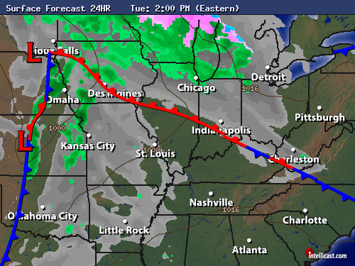
Well, today we seen sunny skies across the area however tomorrow we will be looking at something slightly different. I'm looking for partly to mostly cloudy skies across the area. I say partly to mostly cloudy because a few breaks in the clouds could be possible from time to time. However some more clouds will move in later that evening / night along with a few light flurries possible. This is only a slight chance. Around 10%. I look for any precipitation to mainly stay from I-70 south. You can see in this weather model below.

Still I cannot totally rule out the chance of flurries or a light mix. This would be extremely light (IF ANY). Again I believe that this will mainly be a I-70 south event. Otherwise expect a high Tuesday of 49* degrees and a low around 26* degrees. Wednesday I look for partly cloudy skies through out the day with a high around 53* degrees and a low that night around 29* degrees.
But the good news if you ready to start feeling like Spring is mild weather is coming soon!! Yes, I see highs in the 50s and 60s once again by the first week of April!! Which is only around 4 day away!!
But until then I have something else to help keep you bloggers warm! Did you know it's possible for a rainbow at night?? Well it is! Take a look.
A RAINBOW AT NIGHT: Recipe for a rainbow: Add bright sunlight to raindrops and voila!--a beautiful band of multi-colors arcs across the sky. With such an ingredient list, you might suppose that rainbows can only be seen during the day, yet on March 24th Ethan Tweedie of Kamuela, Hawaii, recorded this spectacular example long after dark:

"It was a moonbow," explains Tweedie. The bright moon played the role of sun, illuminating nightime raindrops falling through the damp Hawaiian air. "I've been trying to photograph a moonbow for a long time. Last night I was driving back from the Volcano there it was!"
Tweedie's long exposure revealed something even more rare: a secondary moonbow. It's the faint 'bow arciing above the brighter primary. Primary rainbows are caused by single reflections inside raindrops; secondary bows are caused by double reflections. It was a night to remember, indeed.
I wish you all a great evening and an Awesome Tuesday!
God Bless!
Friday, March 25, 2011
Winter Is Over, Still We Have A Winter Weekend Forecast!! 10* Degrees Below Average With Snow Flurries On The Way!!
Okay bloggers the weekend is coming!! Yes, So what's the weekend weather looking like? Well, lets take a look.
First off lets ok at these cool temperature!

This map above is a look at Saturday's highs. Which we are looking for a high right around 42* degrees. We have been running around 10* to 11* degrees below average over the past few days! And again we will be around 11* degrees below average tomorrow. Average high for this time of year is right around 54* degrees. We have been seeing highs the past few days in the low 40s! WOW You can see in the map above how the jet stream is keeping us in this cooler air and all the nice mild weather well to our south. This will pretty much be the story until we head closer to the end of the week into next weekend!
With that being said. We also have some light snow in the forecast!

Now before you freak out lol I'm not looking for any real accumulating snowfall. Just a few light scattered snow flurries across the area by Saturday night into early Sunday morning. You can see in this chart above that the clouds will be in the area for Saturday with that rain / snow moving closer by 8:pm EDT. Scattered snow flurries over Saturday night into early Sunday morning.

You can see in this chart looking into early Sunday morning around 8:am EDT that the main area to see the chance for some minor accumulation will be mostly from I-70 south in and around that area. After the light scattered snow flurries Sunday morning we will begin to clear out by that afternoon to become partly cloudy for the rest of the day. So the weekend will feel like winter however 50s return by late week into next weekend! So finally we will be back around average. We just have to continue to take it one day at a time for now. I know a lot of you have spring fever but hang in there!
Right now we can expect to be below average both Saturday and Sunday. High Saturday of 42* degrees, A low that night of 20* degrees. And on Sunday a high of 41* degrees, with a low Sunday night around 20* degrees once again...
So with that said, I wish you all a great weekend! Get out and make it a nice one! ;)
God Bless...
Weekend Quick Cast Tonight!
Hey bloggers. TGIF Right?? I wish you all a great day! I will be checking back here tonight with your weekend quick cast so be sure to check back for the very latest!
DEVELOPING.....
DEVELOPING.....
Wednesday, March 23, 2011
Cold Front Passing, We're Cooling And Becoming Stable!
It turns out that there was a wall cloud observed in Crawfordsville, along with 1.25" Inch sized hail!!! Still there where no reports of any tornadoes touching down thank God!
This Wall cloud was expected as the supercell that went through Crawfordsville was rotating so much at one point and time and had such a hook on radar. Take a look.

This was just before it entered Crawfordsville. Just look at that hook!! I'm glad that everyone is safe and okay! Please remember that if you hear the tornado sirens or hear a tornado warning is in effect please don't run to the windows to look out. Just get to your safe spot as quick as possible!
Again Thank God no tornado touched down and everyone was safe!

Well, as you can see that cold front has passed over the viewing area and our temperatures have droped FAST! We went from the middle to upper 60s down to currently the upper 40s! Abnd it is a COLD rain outside. Lafayette, picked up 0.10" Inches with still a light rain.
You can see below the radar indicitaed rainfall below.

You can see Lafayette, around 0.10" Inches. Areas of Fountain, county between 0.25" Inches to 0.50" Inches. Areas of Montgomery, county between 1.00" inches to 1.50" Inches. Again this is Doppler indicitied rainfall.
As for the rest of tongiht I'm looking for a low around 27* degrees with steady winds between 10 and 15 mph. Scattered rain showers continue and could change over to a few scattered flurries overnight. Otherwise just cold and mostly cloudy overnight.
So the strong storms are off to our east now as the cooler air moves in. We are becoming more stable!
So get ready for the 20s tonight and the 40s tomorrow!
Large Hail Reports!
We are looking much much better in the WLFI viewing area. All the Strong strong stuff has moved off to our east. Right now I'm only tracking scattered thundershowers in the area.
Good news is I have had no reports of anything touching down with all that rotation in that supercell to move through Montgomery county. However I have had many large hail reports! Here they are below.
Hail Reports.....
Waynetown, 1.75" Inches.
Veedersburg, 1.75" Inches.
Covington, 1.75" Inches.
Lebanon, 1.00" Inches.
Ross, In Montgomery, county. 1.00" Inches.
~~~~~~~~~~~~~~~~~~~~
~~~~~~~~~~~~~~~~~~~~~~~~~~~
~~~~~~~~~~~~~~~~~~~~~~~~~~~
Just amazing! I'll continue to watch the radars over the next few hours just to be on the safe side. If I see anything that needs to be posted I will let you all know!
Stay Safe, And God Bless!


Alright Montgomery county. Your looking better. The worst meaning that supercell is moved out of your area. And good news for people in Boon, county is that this cells is not rotating currently!
Still I have had hail reports from this supercell of 1.75" inches!! Right now if your in Montgomery county you will remain in a tornado warning until 8:00pm EDT. However right now I'm only seeing heavy rain. and frequent lightning in your area!
The worst is now passed Crawfordsville, and this cell is not rotation near as much as it was. Still we are watching it VERY CLOSELY! If you live east of Crawfordsville then still keep storm ready and continue to stay tuned to your local weather station for updates! Still expect dangerous lightning. Large hail. Heavy rainfall.....
* TORNADO WARNING FOR...
CENTRAL MONTGOMERY COUNTY IN WEST CENTRAL INDIANA...
* UNTIL 815 PM EDT
* AT 718 PM EDT...NATIONAL WEATHER SERVICE DOPPLER RADAR INDICATED A
SEVERE THUNDERSTORM CAPABLE OF PRODUCING A TORNADO. THIS DANGEROUS
STORM WAS LOCATED NEAR CRAWFORDSVILLE...AND MOVING EAST AT 35 MPH.
* THIS DANGEROUS STORM WILL AFFECT MAINLY RURAL AREAS OF CENTRAL
MONTGOMERY COUNTY.
THIS INCLUDES INTERSTATE 74 BETWEEN MILE MARKERS 33 AND 45.


THE NATIONAL WEATHER SERVICE IN INDIANAPOLIS HAS ISSUED A
* TORNADO WARNING FOR...
CENTRAL MONTGOMERY COUNTY IN WEST CENTRAL INDIANA...
* UNTIL 800 PM EDT

I'm picking up rotation just south of Waynetown heading east!! If your between Waynetown and Crawfordsville then please be storm ready and be ready to take cover just in case!!!
IF YOUR IN THE CRAWFORDSVILLE AREA THEN BE READY!!! THE ROTATION IS HEADING RIGHT FOR YOUR AREA!!!
Take a loook at this report just in from Covington, in Fountain county! This is what is heading to Waynetown, and Crawfordsville. If your in these areas expect large hail. Dangerous frequent lighting. Gusty winds and heavy rain!
COVINGTON FOUNTAIN IN....
EMERGENCY MANAGER REPORTS HAIL RANGING FROM PEA SIZED TO GOLF BALL SIZE
COVINGTON FOUNTAIN IN....
EMERGENCY MANAGER REPORTS HAIL RANGING FROM PEA SIZED TO GOLF BALL SIZE
PRECAUTIONARY/PREPAREDNESS ACTIONS...

SEVERE THUNDERSTORMS PRODUCE DAMAGING WIND IN EXCESS OF 60 MILES PER
HOUR...DESTRUCTIVE HAIL...DEADLY LIGHTNING...AND VERY HEAVY RAIN. FOR
YOUR PROTECTION MOVE TO AN INTERIOR ROOM ON THE LOWEST FLOOR OF YOUR
HOME OR BUSINESS. HEAVY RAINS FLOOD ROADS QUICKLY SO DO NOT DRIVE
INTO AREAS WHERE WATER COVERS THE ROAD.
THIS STORM HAS A HISTORY OF PRODUCING LARGE HAIL. SEEK SHELTER NOW
INSIDE A STURDY STRUCTURE AND STAY AWAY FROM WINDOWS.

...THE SEVERE THUNDERSTORM WARNING FOR NORTHWESTERN VERMILLION COUNTY
IS CANCELLED...
THE STORM WHICH PROMPTED THE WARNING HAS MOVED OUT OF THE WARNED
AREA.


Those cells to our west just became warned!!
THE NATIONAL WEATHER SERVICE IN INDIANAPOLIS HAS ISSUED A
* SEVERE THUNDERSTORM WARNING FOR...
CENTRAL FOUNTAIN COUNTY IN WEST CENTRAL INDIANA...
NORTHWESTERN MONTGOMERY COUNTY IN WEST CENTRAL INDIANA...
NORTHWESTERN VERMILLION COUNTY IN WEST CENTRAL INDIANA...
* UNTIL 730 PM EDT/630 PM CDT/
Watching Cells! popping!!
Well, bloggers that cell we was tracking did in fact become warned as it pushed off well to our east! Take a look below.

Yes, t hat red box is the severe thunderstorm warning. However it is not in the WLFI viewing area! Still we are tracking all those showers / thundershowers that has popped up to our west moving east north east. I will continue to watch as they move closer and develop.
Looking Good!
Right now there is moderate to heavy rain in Frankfort. Light rain in Tipton, And light to moderate rain currently just south of Kokomo. Good news is even though these cells where growing I'm not picking up hardly any lightning. So mainly just moderate to heavy rainfall in this radar image below!
Chance of some really small hail however nothing has been reported! Right now we're good! ;) Cells still moving East.
Radar image taken at 5:57pm EDT.....

Watching The Radars!
Here's another update on these developing cells. Right now there still isn't any warnings with them however they are still growing! So one could be issued as it continues to move east! Right now Doppler still shows that some pea sized hail could be possible.. However overall Heavy rainfall inside these cells! They are moving east and are heading into Frankfort.
Here's the image as of 5:51pm EDT below.

Watching Pop Up Storms!
We are tracking some pop up thundershowers just south of Lafayette, and just north of Frankfort. These cells are moving east north east. Some possible pea sized could be possible in these thunderstorms however there are no current warnings! Still we will continue to watch them as they continue to develop and move east!

Today's Outlook...
We had a few light showers last night however nothing to heavy. I just wanted to check back in with everyone this morning to let you know what has changed in the forecast for today!
Right now I'm only calling for a slight chance of a few widely scattered hit and miss showers / thundershowers. However rainfall is only expected to be around a tenth inch or so. Nothing to heavy.
Take a look at this satellite image below.

This image was just taken around 10:15am EDT. You can see we are looking at partly cloudy skies across the area. This will be the story through out much of today. Mostly cloudy to partly cloudy skies. You can see in that yellow area. This is where some light rain is starting to pop up. This is what I mean by isolated scattered showers. Some of us may see some while others could stay dry all day.
Not looking for anything severe if we do see any showers or thundershowers which is great news! High in the upper 60s so enjoy it before the 40s return tomorrow through the weekend and into next week...
Tuesday, March 22, 2011
Tracking The Warm Side Of A Big Winter Storm Maker To Our North And Then Northeast!
We have Spring weather to deal with over tonight through Wednesday however come Wednesday night it will feel like WINTER once again! Yes, Winter just doesn't wanna give up. We will see mostly the warm side of this system over tonight through Wednesday while others to our north and then off to our northeast will see the COLD side! The Cold Snowy side this week. Lets go ahead and take a look at what system I'm talking about below.
Tonight...

Yes, this chart above is showing you what things should look like come around 2:am EDT tonight. The warm front will be passing through giving way to a few hit and miss pop up scattered showers. A few rumbles cannot be ruled out. However this rain is looking very light this time around! Total rainfall tonight only around a tenth inch. The most I'm seeing in some areas is around a quarter inch and that would be in any pop up thundershowers.
This warm front will continue to lift north and push off to our east as a cold front then begins to move in by later on Wednesday.
Wednesday Afternoon...

This map is looking at 2:pm EDT Wednesday afternoon. Once this cold front enters the area we will be tracking some scattered showers / thundershowers across the area. The areas in the Yellow is where we will have to watch closely as this is the area I expect any severe weather to develop. As you can see I would expect any severe weather development to be southeast of the Lafayette, area. Still with it being that close to home we will be watching it closely!
Now once this cold front passes the area Wednesday evening / night things are gonna start feeling a whole lot different temperature - wise.
Wednesday Night...

Yes, after the front passes we will see that temperature start to fall! I'm talking about lows Wednesday night in the middle to upper 20s!! Brrrrrrrrrrrrrr That's gonna feel COLD after the 70s we seen earlier this week. lol :) Yes, that polar air is gonna dip down and it's gonna stick around for a bit. Any precipitation still left over on the back side of this front could very well fall as a mix or a few light scattered snow flurries.
As for the rest of this week! Take a look.
Extended Outlook...

So Wednesday we see our highs peak in the upper 60s! Only to FALL FAST to a low Wednesday night in the middle 20s! Thursday and Friday highs will only be in the 30s and 40s. With lows in the 20s!! W-I-N-T-E-R IS Baaaaaaaack! ;)
And these temperature are pretty much gonna be the story through this week into the weekend and into the start of next week. That's Indiana for you! 70s one day then 30s and 40s the next.
That's it for now bloggers. Here's a look at your detailed quick cast below. I'll be sure to check back again soon. God Bless!
Quick Cast.....
Tonight we will look for mostly cloudy skies with a slight chance for a few hit and miss scattered showers possible. A few rumbles cannot be ruled out. Rainfall will be light around a tenth inch. Winds between 5 and 10 mph. Expect a low tonight around 54* degrees.
Wednesday we will look for mostly cloudy skies with a few hit and miss scattered showers / thundershowers across the area. Rainfall between a tenth inch and a quarter inch possible. Breezy! Winds between 10 and 20 mph with a few gusts between 25 - 28 mph. Expect our highs to peak into the upper 60s around 67* degrees with a low falling fast into the middle 20s around 25* degrees.
~~~~~~~~~~~~~~~~~~~~~~~~~
~~~~~~~~~~~~~~~~~~~~~~~~~~~~~~~~~~
~~~~~~~~~~~~~~~~~~~~~~~~~~~~~~~~~~
Monday, March 21, 2011
The First Day Of Spring Was A Great Start To The Season!!
Spring is here and the first day of Spring was a hit! :) I'll get to that in just a minute. First off Lets go ahead and talk a little about what rain is in the forecast over the next few days. Let's take a look at a few surface charts as we go along. First off we do have a slight rain chance in the forecast for tomorrow (Tuesday). Take a look at this chart below.
This chart above is looking at 2:pm EDT Tuesday. You can see I'm expecting mostly cloudy skies through out the day with that passing warm front. This could possibly kick up a few hit and miss light scattered showers. Rainfall only around a tenth inch. The rain chance increases as the day continues. Here's another surface chart below.

This one is looking at 8:pm EDT Tuesday. You can see some scattered rain showers are likely! A few rumbles cannot be ruled out however I'm not expecting anything strong to severe this time around! Expect a high on Tuesday in the middle 60s around 65* degrees with a low that night around 55* degrees. Winds between 10 and 15 mph. Total rainfall through out the day only between a tenth inch to a possible quarter inch in areas.
Now we also have a chance for some more isolated showers / thundershowers come Wednesday. Here's Wednesday's surface chart below.

This chart is looking at 8:am EDT Wednesday. You can see some scattered rain showers are possible however the main event will form along this cold front. However I'm looking for this to form mainly passed the viewing area! Just isolated scattered rain / thundershowers possible for our area! Otherwise mostly cloudy to partly cloudy for the day of Wednesday. A high around 68* degrees and a low that night falling to 32* degrees. Winds between 10 and 15 mph with wind gusts to 20 - 25 mph possible.
~~~~~~~~~~~~~~~~~~~~~~~
~~~~~~~~~~~~~~~~~~~~~~~~~~~~~
~~~~~~~~~~~~~~~~~~~~~~~~~~~~~
Now how about the weather we seen today??? Man it felt good with a high in the Lafayette, area of 70.2* degrees!! Partly cloudy skies and all the birds out singing! I did some bird watching while sitting on my front porch and managed to snap a few pics of the little guys. Take a look.


Everywhere I looked there was a bird or a squirrel... Now that says Spring. Even the wild had cabin fever! lol. We also kicked off the first day of Spring with a small cookout. Burgers and Hotdogs! Oh Yeah!

It just doesn't get any better then that! ;) Let's put it in check.
First Day Of Spring...
High of 70* Degrees! Check!
Sounds Of Spring (Birds And Such), Check!
Family Cookout, Check, Check, And CHECK!
~~~~~~~~~~~~~~~~~~~~~~~~~~~~~~~~~~~~~~
So how did you all spend your first day of Spring??
Sunday, March 20, 2011
Beautiful Full Super Moon Pictures And Also Tonight Is The Start Of Spring!!
Alright bloggers Spring is soooooo close!!!! The count down begins!! It's only hours away. How are you gonna bring it in??
Take a look at the exact time Spring arrives!

Yes, tonight at 7:21pm EDT be sure to yell at the top of your lungs that SPRING IS HERE!!!! lol. And not only is the start of Spring tonight but it's also gonna feel like Spring! Yes, I have some real Spring weather in the forecast over tonight and Monday! Take a look at this chart below.

Yes, we have that passing warm front today that could fire up a few scattered light rain showers across the area. This is about a 30% chance. Also this will raise the temperatures into the upper 50s / low 60s today and only allowing our temperatures to fall tonight to around 54* degrees! This warm front will also allow for 70s! by tomorrow with another 20% chance to 30% chance of a few scattered showers / thundershowers possible. However I'll have more details on that tomorrow.
As for tonight's forecast to bring in Spring it's looking like mostly cloudy skies with around a 20% to 30% chance for a few hit and miss scattered rain showers / thundershowers cannot be ruled out. Expect a low tonight falling only a few degrees around 54* degrees with winds between 10 and 15 mph with a few gusts near 18 to 20 mph possible.
Also the Super Full Moon was last night and it was the closest to earth in around 20 years! 15% bigger and 30% brighter! I took one picture however it really didn't come out to well do to the high clouds over the area. The moon did become more clear the higher it got overhead however I was trying to get it on the horizon. I finally gave up once I seen the pictures didn't come out so well. Still here is the one I took. It just looks like a glowing white light in the sky lol.

Now I do have some MUCH BETTER pictures from other areas around the world! I didn't get any pictures sent in to me so I had to search the web and I found some GREAT SHOTS! Take a look at these amazing Super Moon Pictures below. They really are amazing! :)

This one out of Lindenhurst, Illinois

This one out of St. Petersburg, Florida

This one out of Grand Marais, Minnesota.

This one out of London, England.

This one out of Tehran, Iran.

This one out of Bad Soden, Germany.

And last but not least! This amazing shot of the Super Full Moon was taken out of Szubin, Poland!!
Again these are just amazing pictures!! So if you missed the moon last night I'm sure that these pictures kind of make up for it lol. I wish you all a great Sunday! I'm gonna go enjoy the last day of Winter and get ready to welcome in Spring! I will check back here tomorrow with more details on the rain and Thundershowers to move in Monday and Tuesday!
Take care and as always God Bless!
Start Of Spring And Pictures Of The Full Super Moon!
Alright bloggers! Only a few hours left in winter. Yes, tonight at 7:21pm EDT it will officially be Spring 2011! So start the count down. Maybe bring in Spring with a cookout or something of that nature lol :)
Also last night was the Super Moon. The closest the moon has been to earth in around 20 years! 13% bigger and 30% brighter!! I tried to get some pictures however with all the high clouds over the area they came out a little blurry. I didn't get any pictures sent in to me however I did search around and find some great shots! So I will be back with an update with many Full Moon shots!!
Stay Tuned!
Saturday, March 19, 2011
The Telescopes Are Cleaned Up And Ready To Super Full Moon Watch! ;)

Alright bloggers as you can see above I'm all ready to go tonight!! LOL Yes, I got my Telescope all cleaned up and ready to Moon watch! My sister and I will be heading out to my aunts house tonight where we should have a good view! From her place we should be able to see the moon near the horizon. I will try to take a few pictures however I don't have a great camera so they will most likely look like a big round white ball lol. Still we will know it's the moon! ;)
If any of you get any pictures I would love to post them here on JIWB. So you can send them to me at dobby1717@aol.com Have fun tonight bloggers! I'll check back soon.
For the moon watch forecast tonight see the last post just under this one!
Super Full Moon Forecast! Take Pictures And Enjoy!!
Okay bloggers! Here's the deal for tonight's Super Full Moon forecast. I do think we will get a view of it! However we may wanna get out and see it as soon as possible tonight! This is because more clouds will be moving as the night continues. So I'm afraid that if you wait to long to go out and take a peak at the sky you may not get a good look at it. Here's the outlook I put together below.

So partly cloudy skies across the area however becoming mostly cloudy as the night continues. Still if you get out and view it early you should get a peak at it! Plus if you can view it early on the horizon then that is when it'll look it's biggest and brightest anyway! So good luck! I really hope you all get a good look at this moon. It really is amazing. And again if you can get any pictures I would love to post them here on JIWB. You can send them to me at dobby1717@aol.com I look forward to any pictures you can get of this Super Full Moon! ;)
Now the reason we will see more clouds move in as the night continues tonight is because we will have a Warm front push through the area over Sunday bringing some rain and maybe a few thundershowers as well. Take a look at these surface charts below.

This chart above is looking at Sunday morning around 8:am EDT. You can see the clouds over the area with rain moving closer. Scattered rain showers will be likely across the area off and on through out Sunday. I cannot rule out a few scattered thundershowers as well.

Scattered showers still around the area by 8:pm EDT Sunday night. Warm front will be passing over the area Sunday night when means we won't see a big drop in the temperatures. I'm looking for a high Sunday around 59* degrees with a low only falling a few degrees around 56* degrees.
So that's the latest for now bloggers. Again I would get out as early as possible to view the moon tonight just in case the clouds move in early! Take pictures and enjoy! ;)
Take care and God Bless!
Working On The Super Full Moon Forecast!
Alright bloggers! GOOD MORNING! HAPPY SATURDAY!!!! I'm about to go through some weather models and then I will be right back here with a look at tonight forecast! Will we be able to view the Super Full Moon? Check back to find out!
Again if you can get pictures I would love to post them here on JIWB. So please send them to me at dobby1717@aol.com Thanks bloggers! ;)
I'll check back.....
Again if you can get pictures I would love to post them here on JIWB. So please send them to me at dobby1717@aol.com Thanks bloggers! ;)
I'll check back.....
Thursday, March 17, 2011
Spring Is In The Air And Nature Give Us A Chance To See The Super Full Moon This Weekend!
Bloggers Lafayette, hit a high today of 71.8* degrees!!! Can you believe that? WOW Today really felt like Spring was in full force mode! lol. 71* degrees. Just GREAT! What nice weather for St, Patricks Day! Which I hope everyone had a great one. Even Remington, hit a high today of 71.0* degrees! WOW just amazing. We did see a few peak wind gusts this afternoon around the viewing area between 25 and 30 mph! Take a look at these wind reports.
Wind Reports.....
Lafayette, 31 mph.
Fort Wayne, 30 mph.
Kokomo, 28 mph.
Remington, 27 mph.
~~~~~~~~~~~~~~~~~~~~~~~~~~~~~~~~
But the good thing about the wind is it rushed into the house if you had your windows open, (Which I'm sure a lot of you did!). Nice fresh air felt great to let into the house. Even got some spring work done. Speaking of spring! Take a look at this. I snapped a few pictures while I was out this afternoon.

Yes, the trees have been budding like crazy across the area! I don't know why but I always look for this every year come Spring time. lol. I know it's nuts haha. But it's just one of those little signs! Also I was surprised to see that the Silvermounds are already starting to come back!

Yes, my sisters pride and joy right here lol. They were so big last year and their already starting to pop back up outta the ground. There's not many of them just yet however soon enough they will be all over the place! Again it's just another sign that Spring is right around the corner. March 20th at 8:21pm EDT on the nose. So be ready to welcome it in... I have more Spring weather in the forecast! Take a look at your quick cast below.
Quick Cast.....
Friday we will see Mostly cloudy skies with a few peaks of sun not totally ruled out! However I'm still keeping around a 20% chance of a few hit and miss scattered showers through out the day. not everyone will see rain. This would be a really scattered event! Rainfall around a tenth inch or less. expect a high around 63* degrees near 70* degrees again if we do in fact see more sunshine! And a low Friday night around 37* degrees. Winds light between 5 and 10 mph.
Saturday we will look for a few early morning clouds however overall we will become mostly sunny to partly cloudy through out the day. Some more clouds may try to move in later that night into Sunday. Expect a high Saturday around 58* degrees with a low that night around 51* degrees. Winds calm between 5 and 10 mph.
~~~~~~~~~~~~~~~~~~~~~~
~~~~~~~~~~~~~~~~~~~~~~~~~~~~~~
~~~~~~~~~~~~~~~~~~~~~~~~~~~~~~

Now everyone! One of our very own bloggers Brow, reminds us that we have a treat from Nature coming our way by this weekend! Yes, it's the Super Full Moon! This will be the biggest moon since 1993. It's expected to look 14% bigger and 30% brighter then your average moon. And this is because it will be closer on Saturday night then it usually is. On March 19th, a full Moon of rare size and beauty will rise in the east at sunset. It's a super "perigee moon"--the biggest in almost 20 years.
I could continue to explain how it will be bigger and brighter or I can just show you all this video below! So take a look...
So because it has been almost 20years since this happened last I would suggest you try and get a look at it! So the next question is "Will the weather permit the super full moon view?" Well, take a look at the Saturday night forecast as of now!

That's right at this time I'm expecting Partly cloudy skies across the area during moon rise. So I believe that we should be able to get a peak at this beauty. If your somewhere that you can view the moon on the horizon then that would be BEST! It will look biggest then and that would be the best time to snap pictures! If you get any pictures I would love to post them right here on JIWB. You can send them to me at dobby1717@aol.com That's your mission bloggers! Get those pictures! ;)
That's it for now! Have a great night and an awesome Friday!
God Bless.....
Subscribe to:
Posts (Atom)