Wednesday, January 30, 2013

Dangerous Wind Chills!

Take a look at the final rainfall totals from around the area this morning. Everyone coming in with over an inch of rain. 2.05" inches fell in areas of Jasper county up around Rensselaer. 1.73" inches in Logansport. Along with 1.36" inches in areas of Lafayette and 1.10" inches fell across Fountain, county in the Covington area.
 
The National weather service does have a Flood Warning issued for portions of the following rivers.
EAST FORK WHITE RIVER...MUSCATATUCK RIVER...WHITE RIVER...WABASH
  RIVER...EEL RIVER...
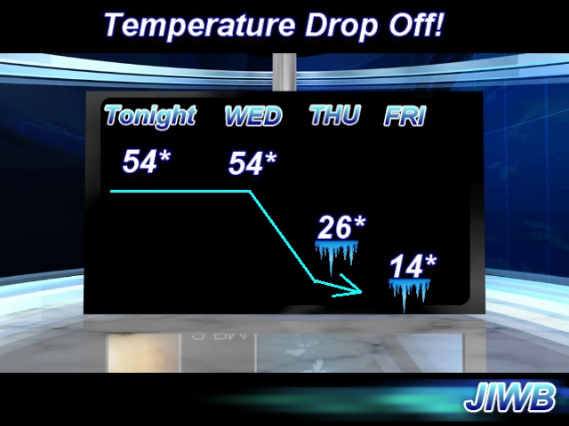
Now as we head through out today we will continue to see our temperature fall. We will see a low tonight of 16* degrees! Winds will be blowing between 15 and 20 mph gusting between 25 and 30 mph. Very blustery tonight, wind chills will be something to keep an eye on over the next few days. With winds gusting to 30 mph and a low expected to be around 16* degrees tonight it will make things feel much colder. Wind chill values tonight will be between -5* and -7* degrees. Bundle up!!
If you think tonight is going to be cold, just you wait! Tomorrow will be EVEN colder. I'm expecting a high Thursday of only 21* degrees. A low Thursday night of 1* degree. Winds will be between 15 and 20 mph gusting to 25 mph at times. This will make for a nightly wind chill anywhere between -15* and -20* degrees. This is dangerous wind chills. I'm talking about frostbite possible in 30 minutes! Please take caution and dress very warm.
You can see all the cold air I'm talking about in this image above. we will have a chance for a few light snow flurries in the area as we head into tonight and possibly tomorrow. Nothing much. The cold will remain our big topic over the next few days! So do your best to keep warm bloggers. Take care and God Bless!

Tuesday, January 29, 2013

Thunderstorms tonight, followed by a big temperature drop off tomorrow!

Highs in the 60s today. In January!!! Well, we're about to pay for it. It's like I have always said, Mother nature is like I big rubber band. The more you pull it from its natural state (Meaning normal highs, lows, weather patterns, etc) the harder it snaps back to normal! And that's what we're about to do.
 
Above is a look at the radar image at 7:pm EST. We're tracking some thundershowers to our west out ahead of a strong cold front. This will be the story into the overnight hours. We are in a slight risk for severe weather however I'm thinking that most of the severe weather will stay in southern Indiana and then farther south from there. Still a stray strong cell cannot be totally ruled out at this time. Otherwise I believe our main threats tonight will be heavy heavy rainfall which could lead to some isolated  localized area flooding. As well as high gusty winds in and out of storms!
Above is a look at a surface chart for 1:am EST tonight (Wednesday). You can see that cold front moving in. Notice all that COLD and snow just to the west of this front! This is the January weather fighting back with a vengeance! Our low tonight of 54* degrees will be our high tomorrow. Instead of warming through the day our high will be falling! Take a look at the forecasted highs over the next few days below. Its a big temperature drop off..
Get ready bloggers. Stay weather ready, or should I say (Stay temperature ready). Its so hard to get use to this kind of weather pattern, its no wonder everyone keeps getting sick across the area.
 
I'll check back as needed with weather updates! Take care and as always, God Bless.

Wednesday, January 23, 2013

Its been awhile

Just wanted to stop in and let you all know that I'm very sorry I haven't posted in a short while. I have been very sick with the flu over the past few days. This flu is going around like crazy, I've already had two different kinds :/ I'm trying to get well again and I will hopefully be back on here very soon. Take care bloggers. God Bless.

Thursday, January 17, 2013

Coldest its been all winter! Lows near zero before wind chill!! Budnle UP!!

We will see a brief warm up over Friday and Saturday as a quick moving warm front pushed through the area bring some highs in the middle 40s to low 50s possible. Partly cloudy skies across the area. This is all just before we see the deepest cold set in of the season! Our coldest days are ahead temperature - wise.
Above is a look into Saturday's high which will be our warmest day this week, our warmest day for a while really. Highs in the lower 50s likely with partly cloudy skies.
 
Saturday night we will start our cold temperature trend with a low falling to 13* degrees! Brrrrrrr is right.
As we head into Sunday through Tuesday we will see highs only in the teens and 20s with lows in the single digits across the state. Wind chills will be below zero! We will have to watch that very closely. I just went out and got some new gloves for me and my loving girlfriend. Gotta stay one step ahead of the weather!
Looking into Monday's high in this temperature chart above you can see we're only hitting a high around 14* degrees! Just crazy cold!! Monday night will be one of our coldest nights with a low falling to 5* degrees or colder in areas. Remember this is without wind chill. This is the actual forecasted temperature! Wind chill will be well below zero.
Looking ahead we do have a few chances at some small Alberta Clipper systems in the area as we head into next week however I'm not seeing anything big at this time. The deep cold is our main topic this week. So bundle up and do your best to stay warm! Go ahead and throw a few blankets in the back of your cars just in care.
 
Take care bloggers and God Bless!

Deep cold setting up. Coldest we've been all winter!

We have a deep deep cold about to set in over the next few days! I'm talking about the coldest we've been all winter long! Highs may not even reach 20* degrees. I'm going to work on some details for this forecast and will have more answers up for you all very soon. In the mean time go ahead and find your heavy heavy coats, hats, gloves, etc. Brrrrrrrrrrrrrrrrrrrr
 
Stay Tuned!

Saturday, January 12, 2013

Soggy start to the weekend. Flood warnings in effect!

We have some weather changes on the way bloggers. It's been a wet few days with our mini melt down weather - wise. All that snow we had got washed away with the rain. The ground is soggy but its nothing compared to what we have ahead of us! Flood watches and warnings already in effect just from our snow melt and rain this week. With even more rainfall on the way.
 
...A FLOOD WARNING CONTINUES FOR PORTIONS OF THE FOLLOWING RIVERS...
  BIG BLUE RIVER...DRIFTWOOD RIVER...EAST FORK WHITE RIVER...EEL
  RIVER...MUSCATATUCK RIVER...WABASH RIVER...WHITE RIVER...
~~~~~~~~~~~~~~~~~~~~~~~~~~~~~~~~~~~~~~~~~~~~~~~~~~
You can see in this image below how the Wabash River is looking and is expected to look after the rain this week.
 
You can see we're currently standing at 8.52ft. We're expected to peak at 1:am EST Tuesday at 13.7ft. Minor flood stage is at 11ft so we will be a good 2.7ft above flood stage! If you live by the rivers this is something to take note of over the next few days.
Above is looking at a surface chart into Early Sunday morning. We will be tracking a strong low pressure system through the area giving way to some heavy rain at times. We could easily see rainfall between Saturday night into Sunday morning between 1" and 2" inches!
 
Here's your weather break down below.
Tonight we can expect to see clouds move into the area later this evening. Followed by rain showers into Sunday morning. Winds will be between 5 and 10 mph to 10 and 15 mph at times. Look for a low tonight around 34* degrees.
 
Sunday we will start the day with a rain to rain snow mix. Total rainfall between tonight and Sunday will be between 1" and 2" inches in areas. Winds will be between 10 and 15 mph. Expect a high Sunday around 38* degrees and as that cold front passes through we will drop to a low that night of 17* degrees! Winter is back!
 
Monday we will look for clearing skies through out the day with a cold high around 29* degrees. Even colder that night with a low around 17* degrees. Bundle up!
 
So as for next week here's what we'll have to keep an eye on!
Cold temperatures will filter back into the state as we head into next week with increasing chances for a few Alberta Clipper systems in the area. some models indicate an active pattern setting up for Alberta clippers. So we will watch that.
 
That's it for now bloggers. Enjoy the nice weather today before things get cold and soggy once again.
 
God Bless!

Tuesday, January 8, 2013

Looking Ahead Into The Month Of January! Also JIWB Sweatshirts!!

 
I'm glad a lot of you took a liking to my post yesterday about the HAARP project! It is a very interesting topic. Really a matter of opinion, Some believe it can control our weather while others don't. One thing I know for

a fact is like Duane, said. "I am often skeptical of these kinds of theories. However. the extremes in weather patterns in recent years makes me think that something is going on!!!". This project has been going on sense 1990 and we sure have had some crazy weather between then and now.
Speaking of weird weather. Duane was also asking me about a possible active weather pattern for the month of January. Well, I do have a few things we will watch as we continue through this month.
 
Right now the NAO, and AO models are showing signs of being in a neutral phase over the first half of January at least. However I do see an increase in Alberta Clipper chances for our area. So a better chance of multiple smaller snows. Also I'm watching for another cold pattern to try and set back into the area as we head into the 14th and 16th of this month. So a lot to watch.
 
I feel like we haven't seen near enough snow this winter season. Take a look at the data from last month. December.
Indianapolis -0.59" Inches
Lafayette, +0.03" Inches
Bloomington, -1.11" Inches.
 

December 2012 was among the snowiest December of record for much of central and southern Indiana. With 14.8 inches of snowfall for December For portions of southern Indiana, this was the most snow since the historic snow of December 2004. Snowfall totals ranged from 6 to near 20 inches. Snowfall did not begin until the 20th, but when it did, the snow made up for lost time.
The big snow of the month occurred on 26th, when a strong winter storm approached blizzard conditions and dropped 4 to more than 12 inches of snow on much of central and southern Indiana. Wind gusts approached or exceeded 40 mph at the height of the snow. Snowfall totals were less for west central and northern Indiana and in portions of south central and southeast Indiana that received a combination of rain, sleet and snow.
Another snow storm quickly followed late on the 28th and early on the 29th. This system did not have strong winds, but portions of southern and central Indiana received 3 to 8 inches of snow. The last snow of the month fell on New Year’s Eve as much of central Indiana received 1 to 3 inches


Tonight I'm calling for partly cloudy skies across the area with a low around 30* degrees. Winds light between 10 and 15 mph.
 
Wednesday we will see mostly clear to partly cloudy skies with a high around 43* degrees. The start of a brief warm up. A low Wednesday night around 28* degrees with winds between 5 and 10 mph.
 
 
As we head into Thursday that's when we will be tracking our next system in the area. Falling in the form of rain this time around as highs will be in the middle 40s around 46* degrees. Low Thursday night around 45* degrees. At this time rain showers could continue into early Friday giving way to a final rainfall total near one inch.
 
 
And last but not least! Over Christmas my girlfriend went onto www.Cafepress.com and made me a JIWB weather hoodie! You can see it in the images below.

It's a really nice and really warm sweatshirt!

 
Have a great day bloggers! Take care and God Bless!

Monday, January 7, 2013

"HAARP" Can it effect our weather??

I have recently been turned onto something called "HAARP". Have any of you heard of this? The HAARP program started back in 1990 so its nothing new. However I just heard about it. So what is it exactly? and what does it have to do with a weather blog?

What is HAARP?

HAARP stands for The High Frequency Active Auroral Research Program. The goal of this program is to further advance our knowledge of the physical and electrical properties of the Earth's ionosphere which can affect our military and civilian communication and navigation systems. The HAARP program operates a world-class ionospheric research facility located in Gakona, Alaska. 
HAARP (High-Frequency Active Auroral Research Program) is a high-powered radio transmission research facility jointly operated by the US Navy, Air Force and several universities. Because of the high secrecy surrounding the government HAARP project, many theories have risen trying to explain what HAARP is and does. Most of them are simply wild speculations, based on fears about what "they are doing up there."
 
The reason why I'm posting about this now here on JIWB is because a lot of conspiracy theorist believe that the high powered radio transmissions into the ionosphere can effect our weather by effecting our jet steam patterns etc. Here is a video talking about why people believe that this project can effect our weather below.


With all that said, You be the judge. Now if you go to the home page of HAARP they say that HAARP isn't capable of effecting our weather, and heres why.

Is HAARP capable of affecting the weather?

The HAARP facility will not affect the weather. Transmitted energy in the frequency ranges that will be used by HAARP is not absorbed in either the troposphere or the stratosphere - the two levels of the atmosphere that produce the earth's weather. Electromagnetic interactions only occur in the near-vacuum of the rarefied region above about 70 km known as the ionosphere.
The ionosphere is created and continuously replenished as the sun's radiation interacts with the highest levels of the Earth's atmosphere. The downward coupling from the ionosphere to the stratosphere/troposphere is extremely weak, and no association between natural ionospheric variability and surface weather and climate has been found, even at the extraordinarily high levels of ionospheric turbulence that the sun can produce during a geomagnetic storm. If the ionospheric storms caused by the sun itself don't affect the surface weather, there is no chance that HAARP can do so either.
~~~~~~~~~~~~~~~~~~~~~~~~~~~~~~~~~~~~~~~~~~~~~~~~
~~~~~~~~~~~~~~~~~~~~~~~~~~~~~~~~~~~~~~~~~
Again with that said I'll let you be the judge. I found this topic very interesting and figured my fellow weather lovers would also.

Thursday, January 3, 2013

Wind Chills Of -2* Degrees!

Feels like I haven't blogged in forever as this flu has been keeping me down. I'm still fighting it however winning the battle! Everyday I get more energy back and continue my climb back to a healthy me. I hope none of you have had to go through this nasty flu that's been going around.
 
Anyways enough about that, lets get talking about the weather. Its what you all came here from in the first place. Right now we have a more quite pattern setting up for the rest of this week with calm skies. Here's a quick two day break down below.
 
Today we will see mostly sonny skies through out the day, it will be COLD! Highs only reaching 30* degrees if we're lucky, Even colder tonight with a low of 17* degrees. Winds will be between 10 and 15 mph so wind chills will be something to watch.
 
Friday we will see much of the same with mostly sonny skies across the area. Highs will again be cold in the upper 20s with a low Friday night around 17* degrees. We will again be watching the wind chills as winds will be between 10 and 15 mph gusting to 20 mph at times.
Looking at the wind chill values for tonight you can see I'm expecting them to feel like 0* degrees! Even colder wind chills tomorrow night with winds gusting to 20 mph. It will feel like 0* to -2* degrees. Bundle up bloggers, Hats! Coats! Gloves! ETC!!!
 
Here's what we have to watch weather - wise over the next few days / week.
Clear skies over the next two days, We do have a shot at some scattered snow showers across the area as we move closer to the weekend, again nothing set in stone, it would just be a few flurries / snow showers. And we're looking for a brief warm up as we head into next week when 40s make a move on us.
 
I'm going to take a look into how much snow we've already seen this winter along with a few other weather records and then I'll be back here. Have a great day bloggers.

Tuesday, January 1, 2013

Down with the flu.

Hey bloggers. I'm really sorry I haven't been able to keep up with the blog this week, I like many others lately have been down with that nasty flu! It knocked me off my feet. I have been bed ridden for the past week. Missed over 15 hours of work. Its a killer. I hope none of you are suffering from it.
 
Good news is I'm finally starting to feel better and I'm looking forward to tracking some more crazy Indiana weather with you all! We will go at it hard starting tomorrow. Thanks so much for your understanding.
 
HAPPY NEW YEAR!!! 2013!!!!