Tuesday, August 17, 2010

Temperatures Are Still Running Above Average. But Green Snow Is In The Forecast! Where? When? And What The Heck Is "Green Snow?"

Well, I have gone through the latest temperature models and some agree while others are showing temperatures sky high! lol. Right now I'm looking for slightly above average temperatures through out this week into next week. But will we see 90s? Well, not all this week! Right now I believe from today through Friday we will look for highs in the low to middle 80s. However heading into the weekend I see temperatures going back up into the upper 80s! And the MOS models showing possible 91* degrees back in the forecast come this Friday into Saturday! However the MOS models have been running a few degrees higher then what the real time temperature has been reaching. So here is a quick look at what some models are expecting our weekly temperatures to be below.

WED, HIGH 85°

THU, HIGH 86°

FRI, HIGH 88°

SAT, HIGH 86°
~~~~~~~~~~~~~~~~~~~~~~~~
Now on both Friday and Saturday the MOS models are calling for highs in the upper 80s to low 90s possible. However like I said above the MOS models have been running a few degrees above what the real temperature has been reaching. So with that being said I have gone with another model which is calling for the highs posted above. I think they will be much closer to the real time temperature as of the latest model data. So yes, currently we are cooler then we were this time last week however not as cool as we would like to be! So in that case I found something that I feel may help cool you all off if only for a moment! ;)

It's called "Green Snow". And it's in tonight's forecast in Antarctica!! Take a look below.


Don't forget to check out www.JIWB2.blogspot.com for your latest and always up to date forecast!

GREEN SNOW: Tonight's weather forecast in Antarctica calls for a 35% chance of green snow. Yes, green. It turns that color during geomagnetic storms, as shown in this August 1st photo from Nick Roden of Australia's Davis Station on the Antarctic coast:


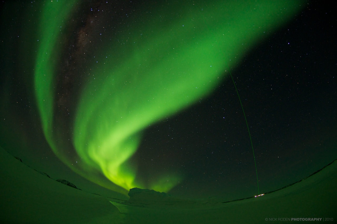
"We've had some fantastic aurora displays lately--bright enough to reflect from the snow," says Roden. In addition to the green auroras, there is also a green laser lancing up from the research station in the background. "That's our LIDAR, which we use to study the upper atmosphere."

A new episode of green may be in the offing. A coronal mass ejection (CME) is expected to deliver a glancing blow to Earth's magnetic field on Aug. 17th or 18th, and NOAA forecasters estimate a 35% chance of polar geomagnetic activity when the cloud arrives.

Temperature Cast Developing..........

Hey bloggers be sure to stick around for the latest temperature cast coming your way in just a few! How long will the 90s stay away? I'll let you know!

Stay tuned.

Monday, August 16, 2010

Justin's Indiana Weather Page Is Back With Live Local Radar!

Hey bloggers!! I have heard your request for the "Indiana weather page" and I put together a new one! Now I just whipped this together in a few short hours so if it's missing something feel free to let me know. I tried to get everything on there that the old one had. But you can be the judge of that! ;) There is also a follow button posted on the Indiana weather page you can click, Or you can share it with your Twitter, or Facebook friends with a button on the bottom of the page as well!

Anyway the new link is below.

www.JIWB2.blogspot.com

So head on over there and check it out! Just be sure to come back here for your frequent weather update! ;)

Sunday, August 15, 2010

Slightly Cooler Temperatures Are On The Way!

Slightly cooler temperatures are upon us!! Find out how cool and how long it will last coming up in tomorrow's weather cast!

Stay Tuned...

Friday, August 13, 2010

Looking Good Weather - wise.

I checked out a little more data and yes these storms are in fact weakening as they continue to move closer to the Indiana state line. The Echo tops that were reaching 500ft have dropped to 450ft and falling. This is a good sign!

Still we will look for light to moderate rainfall through the overnight hours. A rumble or two cannot be ruled out, but "Nothing" strong / severe. Maybe a few breezy winds but nothing to gusty to worry about. Over all weather - wise things look good!
Radar Image Taken At 10:04pm EDT...

No warned cells at this time! Strongest stays north of Remington.

Image taken at 9:35pm EDT.....
Okay what this radar summary above is showing us is the cloud heights! Right now the cloud heights AKA "Echo Tops" are only at around 300ft to 350ft which isn't really that bad! The 500ft Echo tops will be just north of the Remington area which is good news. Yes, these storms are slowing dying out as they move closer to the WLFI viewing area. Good news is I'm not currently seeing any severe thunderstorm warnings or any warning of any kind with this system at the moment. Parts of IL, does have a severe thunderstorm watch issued but again no warned cells to talk about at this time. And also the strongest of the system is looking to stay north of Remington. Still we can expect to see moderate rainfall into the overnight hours. Along with a few gusty winds.

Now I will continue to keep watch on this and I will check back as needed...

Developing Update!

Update on the way for the storm system in IL!

Stay Tuned...

DEVELOPING.....................

Weekend Weather Cast.

SATURDAY PROG CHART.....
This slow moving warm front is still trying to get through the state of Indiana. Above is a Prog chart I put together for you all showing where this warm front will be late, late tonight into Saturday early morning. This is the last of this terrible heat wave before we can start to get our temperatures back down to normal after the weekend. So yes, Highs will hit into the middle 90s once again before this is all over.

With that being said this could pop up a few scattered hit and miss showers / thundershowers across the area Saturday. Mainly Saturday evening / night into Sunday. Now yes, the National weather service does have the WLFI viewing area in that slight risk for severe come Saturday however I have gone through the weather models as of this afternoon and currently I'm thinking the best chance for severe if any would stay in the central IL, area. Still we cannot rule out that chance for some scattered showers / thundershowers here at home.

Now as I said above we will start to see a nice and much needed cool down to start the work week. Yes, temperatures will drop back into the middle 80s! This will still be around 5* degrees above our average for this time of year, However it will feel awesome after all these continued 90s over the past week. Take a look at the temperature model for Monday's highs below.MONDAY TEMPERATURE MAP...
See all the yellows from Lafayette IN, North? Yes, that is the 80s coming our way!! But how long will they last?? That's the question! ;) but will get to that another day. Right now lets check out your weekend weather cast.

Weekend Weather..........

Saturday we will start out dry with mostly to partly cloudy skies over much of the area. More clouds will move in that evening along with some scattered rain / thundershowers possible into Sunday. Watching for any severe development however at this time models indicate anything severe to be closer to the Central IL, area. (Still Watching Closely For Any Changes). Rainfall is looking between .10" and .25" inches. Highs will reach into the middle 90s once again as this warm front pushes through the area. Lows will only cool to 70* degrees. Winds will be calm between 10 and 15 mph with light gusts to 20 mph possible.

Heat Index.. Yes, Heat Index will again be at the dangerous levels between 100* and 111* degrees!
~~~~~~~~~~~~~~~~~~~~~~~~

Sunday we will start out with some scattered rain / thundershowers which should give way to some mostly to partly cloudy skies by that afternoon / evening. Rainfall between .10" and .25" inches. Highs will be in the low 90s with lows falling into the middle 60s for a change. Winds will be light between 3 and 5 mph.

Heat Index.. Not as hot as Saturday's heat index however we could still see them hit into the upper 90s around 98* degrees.
~~~~~~~~~~~~~~~~~~~~~~~~~~~~~~~
~~~~~~~~~~~~~~~~~~~~~~~~~~~~~~~~~~


We still have that "Excessive Heat Warning" in effect for > Carroll, Warren, Tippecanoe, Clinton, Fountain, And Montgomery, coutnies until 8:00pm EDT tonight.

Thursday, August 12, 2010

Longest Hot Spell In More Then 22 Years!

That's right bloggers this is one of the longest hot spells in more then 22 years! So how much longer do we have to put up with it? Keep reading to find out.
Well, bloggers we are still talking about the same weather pattern. "The heat wave". Let me start things off once again with an "Excessive heat warning" that is in effect for the following viewing area counties below.

Carroll, Warren, Tippecanoe, Clinton, Fountain, And Montgomery, counties. This warning is in effect until 8:00pm EDT Friday.
~~~~~~~~~~~~~~~~~~~~~~~~~~~
~~~~~~~~~~~~~~~~~~~~~~~~~~~~~~~~~
This is really something to take note of as this is dangerous weather! I know it looks like a beautiful day when looking out the window, however if you step out and start working too much, For too long in this heat things could turn ugly in no time! This heat wave is going to continue as another warm front pushes through the area starting tomorrow / Friday. Check out this image I put together for you below.
Friday Prog Chart.....
~~~~~~~~~~~~~~~~~~
I recorded a high yesterday of 91* degrees. Also a heat index between 100* and 105* degrees! Amazing. And this is the same story we have been seeing today. And it will continue through the weekend. But I do have some good news! Yes, this crazy heat wave is almost over. Take a look at the latest MOS model runs below.
Yes, come this Monday we will start to see things get back to normal. Temperatures dropping back into the 80s. This will feel like the "AC" has been kicked on high outdoors lol. So hang in there! Just continue to do your best to beat the heat! Check up on your neighbors and also don't forget the pets!
I'll have your weekend forecast posted later on tomorrow! See you then.

Wednesday, August 11, 2010

Running 11 To 12 Degrees Above Average!! "Crazy"

Yes, Hot and muggy is the topic for the rest of this week! We have had yet another day in the 90s and it's going to continue into Monday. We still have heat advisories in effect for much of the WLFI viewing area.

This Heat Advisory is in effect for Carroll, Warren, Tippecanoe, Clinton, Fountain, And Montgomery counties Until 8:00pm EDT Thursday...

We have had a number of continued 90* degree days this week! More then average! Take a look at some averages for the month of August below.
Amazing that our average high for this time of year is only around 82* degrees. This means we have been running a good 11 to 12 degrees above average over the past week! We have not only been pushing record highs but breaking them. The record high yesterday "8/10/10" was 95* degrees set back in 1983! some areas of Tippecanoe county top out yesterday with a high of 96* degrees! A new record. This has been a crazy hot summer!
And the heat continues as you can see in this temperature map above. This is what things are expected to look like this time tomorrow. You can see the heat is going to stick around over much of the states. We are talking abut more 90s through out this week. We could hit a high tomorrow "Thursday" of 93* degrees. Dew points in the low 70s which will make heat index around 100* to 104* degrees! This can become dangerous if your out and about to long in this sunlight working!!

Quick Cast..........

Thursday, Looking for Partly cloudy skies over the area however an isolated scattered shower / thundershower cannot be ruled out just yet. 20% to 30% chc. Nothing major / big to worry about is the good news. At this time I'm thinking most of us will remain mostly dry. We can look for more hot temperatures in the area as I look for a high around 93* degrees and lows only falling to 70* degrees. This is a good seven degrees above our average low for this time of year! Heat index will be in the 100* to 104* range. winds will be light between 3 and 5 mph.

Friday, will be much of the same only without the chance of an isolated shower. Yes, we will keep things dry and hot with lots of partly to mostly sunny skies. Highs will again be around 93* degrees with lows around 70*. Dew points will be in the low to middle 70s which means again heat index will be in the 100* to 104* degree range. Winds will be light between 3 and 5 mph.
~~~~~~~~~~~~~~~~~~~~~~~~~~~~~~~~~~~~~~~
~~~~~~~~~~~~~~~~~~~~~~~~~~~~~~~~~~~~~~~~


Now before I let you all go I just wanna take the time and post this image showing your Hot Weather Safety. I'm sure many if not all of you already know this.

Keep cool bloggers. And most important keep you, Your Family, Friends, And your Pets, Safe!

Tuesday, August 10, 2010

Temperature Talk Coming Up!

Yes, we will be seeing this Extreme heat through out the rest of this week into the weekend!

Just how hot could things really get before this week is through?

When could we finally start to cool down?

I'll have all this temperature talk coming up here on JIWB very soon, So stay tuned and stay cool!

Watching The Heat With A Close Eye!

Good afternoon bloggers! Well, we are still looking at the Heat Advisory in effect for a good amount of the WLFI viewing area. Take a look at the Advisory below.
Heat Advisory In Effect For The Following Counties In Indiana.

Carroll, Warren, Tippecanoe, Clinton, Fountain, And Montgomery counties, This includes the cities of Lafayette, Frankfort, Kokomo, And Crawfordsville.

This heat advisory is in effect until 8:00pm EDT this evening.

Impacts: People with health conditions should exercise caution this afternoon. Plan for and be prepared for additional warm temperatures on Wednesday. Consider postponing outdoor activities until the evening hours.
~~~~~~~~~~~~~~~~~~~~~~~~~~~~~~~~~~~~~~~~~~
~~~~~~~~~~~~~~~~~~~~~~~~~~~~~~~~~~~~~~~~~~~
Highs without heat index could reach as high as 94* degrees today! With heat index we will feel like we're in the 100s. Now as far as the rain chances?!?! Well, nothing more then a few light scattered hit and miss showers possible through out this afternoon. Take a look at what I mean in this radar image posted below.This Image taken at 12:35pm EDT.....

So you can tell we are not calling for a big washout today. Not by a long shot. But a 30% chance for a few scattered showers cannot be ruled out.

So the big story is the heat and the heat advisory I have posted above. Please if you can put off your plans for today until this evening in the cooler hours then do so! This heat is dangerous. Remember to drink lots of water and put on light color clothes! Anything to beat the heat!

Monday, August 9, 2010

Been A Busy Summer!

Hello bloggers! It's been a long time no see! how is everyone doing? I'm sorry I haven't been giving you daily updates for the past few months it's just been so busy this summer! But things are starting to calm down if only for a little while before this autumn. So what have I been doing that's been keeping me so busy? Well, I'll tell you.

I have been doing a lot of work inside and outside the house. We finally got new siding and windows! Finally I won't freeze this winter lol :)
Also I signed up for summer Co-Ed Softball and had a BLAST! I met a lot of new and amazing people and we had a lot of fun. We was one of the newest teams in the league this year and still managed to finish in 4th place. Not bad for a newbie team lol :)
And last but not least I finally got my high school diploma! Being home schooled it was a tricky mess trying to get my diploma but I finally found a way. It was sent to me in the mail only around a week ago. Finally I'm finished! :) Now all that's left for me to do is think about taking a six month course on meteorology this autumn. Autumn could be another busy season!So until then let me get back to the Indiana weather blog! ;) Let's check out the forecast below.....

Tomorrow / Tuesday...
I have gone through the latest weather models and data and right now I cannot rule out the chance for some scattered showers / thundershowers possible through out parts of the afternoon. Now this will not be a wash out day so no need to worry about that. Rainfall amounts are only looking between .10" and .25" inches possible. The good thing is nothing is looking like it will become severe if we do see anything. And when we're not seeing rain we will keep the chance for mostly cloudy skies with a few peaks of sunshine here and there possible. Winds will be light between 3 and 5 mph. Now as for temperatures that's another story! We will again be looking at highs in the low to middle 90s!! Highs tomorrow are looking around 95* degrees possible. With lows only falling into the low 70s at around 70* degrees. Yes, it's gonna be another hot one that's for sure!

Wednesday...
We will have to keep in yet another 20% to 30% chance for a few hit and miss scattered showers possible however again this will not be a wash out day. Rainfall amounts are currently looking to be around .10" of an inch or less. When not seeing rain we will see mostly to partly cloudy skies. Winds will a gain be light between 3 and 5 mph. Highs will be in the lower 90s at around 93* degrees. Lows only cooling to around 74* degrees.

Now the main thing we're really gonna have to keep watch on this week will be the temperatures and heat index! Tomorrow / Tuesday is going to be at the dangerous levels heat - wise as temperatures will be in the low to middle 90s. Which means heat index could reach as high as 114* degrees at one point and time! Just as well as temperatures will be in the low 90s on Wednesday means that the heat index could reach as high as 108* degrees! both days will be at the dangerous levels! If you don't have to be out then it would be best to stay in the AC. If you must work outside then try your best to ether do it early in the morning hours or late in the evening. Just be careful and stay safe!

Now we already do have a "Excessive Heat Watch" in effect for many counties in the WLFI viewing area. Counties such as Warren, Fountain, Carroll, Tippecanoe, Clinton, And Montgomery counties. This watch remains in effect from Tuesday morning through Tuesday night!

Stay safe bloggers!

I'll check back again soon.....