Sunday, March 2, 2014

Snow reports are coming in

Here's a look at the snowfall totals coming this morning. Valparaiso, coming in with the highest at 5" inches, Lafayette with 3.7" inches and Kentland, not far behind with 3.5" inches. We do have a slight chance at an additional inch or less of snow as a few scattered snow showers try to move in this evening. Not gonna be much. You can see in this radar image below. It's just tracking farther south then what we would need for higher amounts.
If you have any snowfall reports please post them in the comments on this page or post them on our FACEBOOK! Have a great day bloggers. Thanks for following!

A close look at the weather models.

**Update** As of 1:53am EST.

Reports coming in from northern IL, snowfall already on the ground anywhere from 2" to 4" inches up around Chicago. Also snowfall report from Elkhart, IN of 1" to 2" inches.

The snow is making it's way across the viewing area, About a half inch of snow on the ground in the Lafayette, area currently.  Here's a look at the heavier bands showing up on my personal radar. The snow has to be pretty heavy to show up on this radar. Take a look at the darker blues and greens popping up! (And so it begins) ;)
I'm fighting a nasty sinus cold bloggers so I'm gonna leave you with this update and head off to get some sleep. Please be careful on the roads if you have to go out and stay safe! There is a thin layer of ice under this snow! Take care.

God Bless!
~~~~~~~~~~~~~~~~~~~~~~~~~~~~~~~~~~~~~~~~~
~~~~~~~~~~~~~~~~~~~~~~~~~~~~~~~~~~~~~~~~~~~~~~~~~
Don't forget to FOLLOW US ON FACEBOOK!

As you can see above the snow is slowly starting to make its way into the viewing area. It has moved in much slower then first thought. We have had a few reports of some freezing rain however nothing much across the area. Still roads are SLICK and will continue to become even more slick as the night goes on! You can see those few areas of pink in the radar image above.

I want to use this post to update you on the coming storm as well as show you all the weather models and what kind of data they are putting out. Lets get started.
Above is the Bufkit models that has been very consistent over the past few days calling for around 4" inches of snowfall from this storm.

Next is the MOS model.
The MOS model has been up and down a few times but over all fairly consistent calling for 2 to 4 / a possible 4" to 6" inches. Right now in this image above we're looking at a trace to 2" inches with another 2" to 4" inches on top of that. So a range of 4" to 6" inches.

And last but not least a look at the NAM model for snowfall.
This NAM model is showing a break down of snowfall amounts across the state. With Lafayette and much of the viewing area in that 4" to 6" inch range. Just north and west of Jasper county and Remington, IN in a bit more with 6" to 8" inches. And just south of the viewing area south of Montgomery county picking up 2" to 4" inches.

We have around a 40% to 50% chance of seeing 6" inches of snow across much of the area. Take a look at this map below.
So how much did I change the expected snowfall totals based on this newest data? Not much! I kept us in that 4" to 6" inch range however I extended the range more north then it was in my last post.
Wide area of 4" to 6" inches, I won't totally rule out the chance for locally higher amounts of 7" inches in areas. 3" to 5" inches south of Montgomery, county and sleet and freezing rain around Indianapolis and south. So not much change, I just wanted to show you all the newest data and show you what it is we're dealing with lol. Have a great night and stay safe! And as always, Don't forget to follow us on FACEBOOK!

Saturday, March 1, 2014

Latest as of 8:pm EST Snow storm is right on our door step!

DON'T FORGET TO FOLLOW US ON FACEBOOK! ;)

https://www.facebook.com/pages/Justins-Indiana-Weather-Blog/194210110637780

Not a whole lot has changed in the past few hours when it comes to the snowfall amounts bloggers. Timing is a little slower then expected, Snow showers are just starting to enter northern Newton, and Jasper counties. We should see some snow showers around here (Lafayette) later on tonight. This low pressure system that is producing this monster of a winter storm is pushing so much moisture into this system. Take a look at this!
This is a water vapor map showing you that low pressure system off the west coast, Just look at how much moisture we will have to work with during this storm! Just crazy! This is why so many forecasters have had a problem figuring out how much snowfall we will see. Trying to figure out where the main moisture will see up along that freeze line!

The snow is already building and moving into the area as I mentioned above. Take a look at how many states are being affected by this beast!
Now that this system is on our door step I feel like the bufkit models and the MOS models finally have a pretty good handle on it. Most of my data is pointing me into a 4" to 6" inch range for much of the viewing area. A few spots of Isolated 7" inches. Take a look at the bufkit model below.
Bufkit has been calling for 3" to 4" inches for the past 3 days or so. And it's usually pretty good when it comes to winter weather. Also the MOS models on the QPF are showing a 1 for tonight and a 2 for tomorrow, Which would mean between tonight and tomorrow snowfall totals between 4" and 6" inches. At this time I'm thinking we have about a 50% chance of 5" to 6" inches when all is said and done.
Here's my thinking above. A wide area of 4" to 6" inches however a few areas of Isolated 7" inches cannot totally be ruled out. Most picking up between 4" and 6". I'd say we have about a 70% to 80% chance of at least 4" inches of snowfall.

Here's the break down below.
 1:am EST Sunday above. Heavy snow stretches across the area with snow / sleet mix around Indianapolis and south. Freezing rain becomes problem south of Indy.
Snow showers will go into Sunday morning / early afternoon before starting to tapper off as we head into the afternoon hours. Still scattered light flurries as we head into Sunday evening. Expect a low tonight COLD around 9* degrees, High tomorrow (Sunday) around 15* degrees with a low Sunday night around 1* degree! Very cold!

Don't forget to FOLLOW US on FACEBOOK!

That's it for now bloggers. Stay tuned and stay safe! Here's a link to the National weather service for the latest on the current winter weather watches, warnings, and advisories!

http://www.crh.noaa.gov/ind/

Afternoon Update!

Okay, bloggers I just went through the latest data and have a few changes! Even last night I was starting with lower snowfall amounts then what a lot of other meteorologist were, This is because I just didn't see anything that supported the 11" inches that so many were calling for. And this morning I still have yet to see anything in the data that screams 11" inches to me. In fact I have lowered our amounts just a bit more then yesterday. Lets get started.

Currently I'm looking for mostly cloudy skies today with snow showers moving in later this evening. As we head into tonight around 6:pm and 8:pm we will see the snow become more area wide. Take a look at this surface image looking into Sunday around 1:am EST.
Cold front pushes through  and the winter weather starts coming down hard. Lots of rain and freezing rain to the south of Indianapolis. We are looking more and more to stay all snow according to the latest data, However I won't completely rule out sole sleet trying to mix in at times!

Take a look at this map below. This too has changed from last night. We were much closer to that sleet / freezing rain line this time yesterday, now all snow is looking like the story.
You can see the ice line is now setting up farther south and west. This is great news for us as no one likes freezing rain! Way to dangerous! I'm not seeing any signs of freezing rain in any of my data right now. Both the Bufkit and MOS models give me comfort in this area.

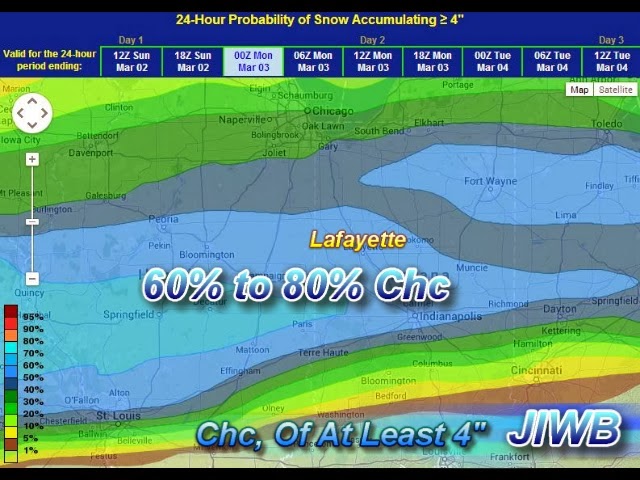
So how much snow can we expect? Well I think that we have a good chance of picking up at least 4" inches from this system. (At least).
above is a chart showing us with around a 60% to 80% chance of picking up at least 4" inches. That % chance gets lower the more south you go of Indianapolis as they will see more sleet and possibly freezing rain at times.

Here's the weather break down below.

Tonight we will see snow showers moving into the area between 6ish / 8ish give or take a little. Snow will continue into the overnight with winds between 5 and 10 mph, gust to 15 mph. Low tonight around 13 degrees as the temperature will continue to fall today as that cold front passes through the area.

Sunday we will see snow showers continue in the morning hours waking up to a world of white. Snow showers will start to slow down / tapper off that afternoon however scattered snow showers will be likely through out the day. Expect a chilly high around 19* degrees with a low around 5* degrees! Brrrrrr. Winds between 10 and 15 mph.
~~~~~~~~~~~~~~~~~~~~~~~~~~~
~~~~~~~~~~~~~~~~~~~~~~~~~~~~~~~~~~~~~~~~

Here's what I'm thinking for snowfall as of now.
Between 4" and 7" inches for much of the viewing area. Slightly lower expectations north with 4" to 6" inches, and a small band with locally higher amounts closer to Indianapolis where that rain / snow change over will make for heavy snow! 5" to 8" inches.

I will have another post tonight continuing to fine tune this forecast. Have a great day bloggers. Stay Tuned!

Stay Tuned

Getting ready to update, going through some more weather data. Stay tuned!