Saturday, February 28, 2009

It Was Windy And Wet To End February. And We Start March With Cool Temperatures!

Take a look at those wind gusts from around areas last Thursday! You can see Danville IL, coming in with at least a wind gust to 43MPH. Lafayette IN, not much behind with 40 MPH.....Remington even had a peak gust to 31 mph..... High winds all around! And we sure knew we was going to see them when we looked at observations in IL, and seen they was having gusts to 40 mph. But Gusty winds was not the only thing we seen a lot of! That's right we also had the heavy bursts of rainfall at times. Here is a few quick reports from our Spring storm.
Rensselaer, you see comes in with the highest amount around our area followed by Lafayette, and Logansport. And the lowest around Kentland, and Remington, area. Not to forget we had our big temperature drop!! I had a temperature that fell from 55* degrees that night around midnight all the way to 33* degrees by early morning as that cold front pushed through! Well, dumb me lol... Forgot and left my window open and woke up freezing! :o/ LOL! Took me all day to get warm again..........

Well, On to the rest of our week!

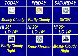
Today we will look mostly cloudy with a chance for a few more light snow flurries. Nothing much nor to add to anything but snowflakes non the less. Yes winter is not over just yet as we can tell with more cold temperatures here for a little while! We will see highs in the 30s with a few nights in the teens! I hope you did not put away your coats just yet! Wind chills will make us feel in the single digits at night near zero by Sunday night. We was seeing 50s as our high just this past week????? Indiana weather for you! Ya got to love it.....

This is that time of year and we will be going up and down for a little while! That's right I said UP. I do see us getting warm again here before long so warm weather lovers don't be sad! ;) I think we will start to slowly warm again by Thursday. I think for most people it is like "Summers coming to fast Winters staying to long" Most in my family are ready for Spring however we to have a few that are really enjoying this cooler weather for the next few days. I love the cold weather which is GREAT because I live in Indiana LOL.. I like to say "If you live in Indiana you have to be ready for all kinds of weather" How true that is!

Well, This month of February, is coming to a end with March being tomorrow and I think we should take a look back at where our average rainfall should be for this month! On average we should only have around 2.2" inches of rain this month.....However we have passed that by a good 1.20" to 1.30" as our final rainfall total for the month of February is right around 3.45" inches. Or at least real close to that mark! This has been a WET month! Now we can get ready for the month of March to start and remember spring is just around the corner. Remembering this is what will help get you through the few cold days ahead in our forecast! :o)

Friday, February 27, 2009

We Had High Wind Gusts And Heavy Rainfall And now Cooler Temperatures Are On The Way???? Winter Is Not Over!

We have had lightning all over the area and light thunder. More like a nice Spring storm nothing bad or severe which is the good kind of storm in my book! We do have heavy rains as the heavy bands pushed through the area. I will post some final rainfall amounts from around the area a little later on tonight as well as wind gusts! First take a look at this Lightning tracker map as you can see all the strikes here in Indiana.Here in Lafayette we really started seeing the lightning and thunder around 12:04AM. No it was not bad and things calmed down rather fast but it was a few good rumbles. IL, did see a few high wind gusts to 40 43 and 45 mph..... Good news is there was no damage reported with that..... I will post more high wind gusts here tonight. Now we will still see a few gusty winds in the early morning however most of the real GUSTY winds should be out of here by 3:am. Still we could see gusts to 25 "maybe" 30 mph and that will lessen as the day goes on..... We will feel a little cooler not only today but for the the next few day! That's right it is still winter and mother nature will not be rushed! ;o) We will be in the 30s as highs and lows in the 20s and at least two nights look in the upper teens to low 20s.....And to make it even better there is a slight chance for a few light snow flurries on Saturday!

Snow lovers don't get to ready I'M only calling for a few flurries nothing that we can get out and have fun in! ;0/ lol..... All the warm weather lovers are liking that! ;o) But if anything it will be a little reminder that winter is not over just yet! And this is the time of year when we go up and down for a Little while trying to come from winter to spring. But other then temperatures the week is looking rather good!

Here is a quick look at your 5-Day Forecast I put together here before I head off to bed.....So be ready for a little Breezy start to your day today and as you see after Saturday the next 3 days look great! No not 50s or 60s like most of us want but we are getting there steep by steep..... Baby steeps that is! :o) I will have more on our windy storm we had an\along with like I said Rainfall amounts and Wind gusts. For now I really need to get some sleep and I will see you here tonight! Till then have a GREAT and safe day....................

Thursday, February 26, 2009

Quick Cast Update!

UPDATE..........AS OF 10:38PM..........

Hey there I have been watching the radars and maps and their have been a lot of lightning strikes in IL, however after watching things closely I can tell that the line of storms are starting to weaken and calm down. The wind on the other hand are not! I have seen wind gusts in IL, already of 43 mph.....This is heading our way as we have already seen the wind pick up a bit! Lafayette has seen winds gusting already to 32mph and higher! WINDY WINDY WINDY..........

This is really what we have to look forward to! We are seeing rain move into our area however the line we are looking for is still in IL, working its way here. I think we will start to see it closer to 11:pm tonight.

Severe thunderstorms I think it is safe to say we will miss that! You will be able to rest with no problem but the wind rattling the window may keep you up :-/ SO winds to 40 mph are VERY LIKELY..... I would be careful about the lightning! There has been a lot of that showing up on the lightning trackers tonight and please remember your lightning safety tips!....................

Watching The Next Batch Of Rain Move In!

OK I'M back with another weather update! You can see the radar image above of the rain and thunder. Thunder is still in north west IL, and the south west of IL, This is the line we will see move our way here later on tonight. Closer to 11:pm or midnight. Now we will not be looking for severe weather which I'M sure most are happy about! ;)

We are not even in a slight risk for severe weather tonight. However I would not rule out a few good booms and possible stronger storms in the southern parts of our great state. This would be South of Indy. We will still have the gusty winds later on tonight with some of the rain / thunder and after as we head into Friday! So tonight we will be breezy with winds between 15 and 25 mph gusting to 40 mph. We can also see these winds gusting to 35 to 40 mph in the morning of Friday before they start to calm down..... We may see a few light snow flurries on the back side of the rain however it will be nothing much at all.

Rainfall is looking between a quarter and a half inch for Lafayette as I already have 0.08" inches and for Newton, and Jasper, counties they could see rainfall around a half inch to maybe three quarters of an inch possible. Again I would not count out a few rumbles tonight but other then that we should be OK!

JUST GUSTY WINDS! I'll check back if needed! Now lets go TRACK!!!!! ;o)

The first line has came through now we get ready form more rain and WINDY!

Hey just checking in again! The first line of rain has made its way through the Lafayette area and I have an amount of 0.02" inches of rain from that quick line with more to come.... I have looked through the latest and I don't think we will worry about Strong storms tonight but still I'M calling for the gusty winds between 35 and 40mph tonight with our next line of rain and possible thunder.....

Rainfall will stay around a half inch to three quarters of an inch possible for the Lafayette area and around three quarters of an inch to an inch up around Newton, and Jasper, counties. The rainfall amounts have fell because like I said the track could still change. Well, it did and now the low is tracking more to our north which will put us in the lesser rain amounts.....This is much better news that is for sure!

So for tonight later on this evening we will see the line of rain and maybe a few rumbles of thunder. I think the strong storms will stay to our south and west this is where it will be most unstable.

Gusty winds around 35 to 40 mph through this evening and still a little breezy on Friday. Heavy rains at time but not a total wash out!

Highs today in the upper 50s right around 59* degrees will make it feel great however if we are going to feel like Spring then we have to take the rainy stuff that comes with it! Have a good one and I will catch you here a little later on with another update....................

Quick Update Before The Rain Gets Here!

Hey Bloggers this is going to be a Quick post as I'M a little behind.....sorry about that :-)


OK As of 2:00am it looks like rainfall has dropped a bit as I was calling for around that inch and a half range for Newton and Jasper counties yesterday. Well, it looks like the track has changed a bit but for the better! I now have rainfall for Newton and Jasper counties around one inch possible. Still we will watch the rivers to be safe..... Rainfall for Lafayette between a half inch and Three quarters of an inch are possible. Yes we still could see a stray thunderstorm but nothing bad! This is also good news. And I also still have the rain moving in after noon time. Still some gusty winds to 35 mph at times maybe even 40 mph. This would also be later on today into really tonight. Into Friday..... So this means Friday morning will be breezy!


I will try to post another update later on today and to keep you posted! We will see a high today around 59* degrees so you can enjoy the morning before the rain gets here.....


Have a good morning and I will check back here soon as needed..........

Wednesday, February 25, 2009

A Red Sky Last Night Really Is A Weather Delight...

Quick Cast................................

Today. We can expect to see Partly cloudy skies and a nice warm day with Mild temperatures in the low 50s. We will see winds light between 15 and 20 mph with a few gusts to 20mph. Lows will be in the upper 20s.

Thursday. Rain with the slight chance for a thunderstorm. We can expect rain to move in in the afternoon with rainfall looking between Three quarters of an inch to one inch possible. The amounts could still go up if the storm track changes again. Any thunderstorms currently does not look to be severe just some good old thunder. We will however watch this closely.....Highs in the low 50s and lows will be in the mid 30s.

Friday. Looking Partly cloudy with highs in the low 40s and lows in the upper 20s. Starting to cool a slight bit.

Extended Outlook. The weekend may have a few light snow flurries but nothing big anything that would fall currently looks light few and far between. Yes a little cooler but not for long with the long range outlook showing us above average temperature wise. Sunday is looking Mostly sunny and nice!
___________________________________


That's right it was a beautiful sunset with that red sky and as you have heard It really is a Delight! And that will hold true for our forecast today! With the partly cloudy skies coming in and highs will be in the 50s today! Warm weather lovers can thank a warm front for this great looking day! We will see the warm front push through today however it is not all good as we will see a cold front follow by tomorrow! This could fire up some thunderstorms as we have the winter weather to our north and west and warm humid air to our south. We will watch things closely however I have good news and not so good news.

Lets go with the good news first! Currently it looks like we wont have to worry to much about severe thunderstorms on Thursday just some good old thunder but for the bad news..... We may have to worry about flooding!..........Currently Lafayette could see rainfall between Three quarters of an inch to One inch of rain. And higher amounts the more north you go of Lafayette. The amounts can still change more if the track changes just a bit. So I will keep watching this and keep you posted with another update later on tonight..... As of now we look to start to see this rain move in by the afternoon of Thursday.

We will feel a little breezy later on Thursday as the rain tries to move out into Friday with a few gusts to 30 maybe even 35 mph. Another windy day But at least temperatures will be rather nice! I e-mailed my friend in Baton Rouge LA, yesterday and was telling her about all the cold wind chills we had last week which was around zero degrees. I was telling her we will be seeing highs in the 40s and 50s which will feel like a heat wave to us here in Indiana, However she has tolled me she will turn the heater on if the temperature drops to the 60s or 50s. So my point is our heat wave would be just another cold day in LA, But I'M sure we will take 40s and 50s no problem! Right? :0) lol..... Let's all enjoy our good looking day today!

Tuesday, February 24, 2009

Warm Mild Temperatures Are In The Forecast And We Will Feel Like Spring With Rain On The Way!

Quick Cast.....................................

Today. We will see highs in the low 40s with Partly cloudy skies. Light winds between 10 and 15 mph. Nice and calm and good weather to get out and fire up the grill! Lows in the low 20s.


Wednesday. Mostly cloudy maybe a few peaks of sun. Highs will be in the high 40s to low 50s. Winds will be a little higher between 15 and 20 mph with a few gusts to 25 mph at times. Lows in the mid 20s.


Thursday. Rain will be back in the forecast with highs in the low 50s. Rain currently is expected to start around 10am or 11am Thursday. Current expected rainfall is between a quarter inch to a half inch possible. We will watch for possible higher amount as we get closer.


Extended Outlook. We will cool down to the 30s again by this weekend but don't get bummed out! It is that time of year where we go up and down and we will rise temperature wise again. However we do have a few light snow flurries back in the forecast for this weekend but we will talk more about that later for now let's just enjoy our MILD temperatures for the next few days. We will be above average but once again....................


That's right warm weather lovers you get to go out and enjoy for a little while and even get ready to track some RAIN! First off what a day it was yesterday! Right? It was just bright and beautiful out! Nice and sunny with the BIG BLUE! That's what I like to call it! I think the Best day is when it is blue skies with some puffy Cumulus clouds! And that is just what we seen.....

Well, to start things off today we will see another GREAT day with as you see above mild temperatures expected to be around 40* degrees which is right around five degrees above average for this time of year. And Partly cloudy skies. You see our fair weather friend will try to stick with us.....There is still a slight bit of snow on the ground however I think it is safe to say that it will be all gone by the time today is over! ;)

Now for the rain I started to talk about at the top of this post! Well, I do see rain in the forecast for Thursday sometime after 10:AM or 11:AM. Now we will keep watching the rainfall amounts closely as well as the timing but for now I think rainfall will be between a quarter and a half inch possible. If amounts change I will let you know. Now I don't see anything severe with this system but there is the chance for a few thunderstorms or rumbles if you will with the system. I will keep you posted as we get closer. For now we have today and tomorrow to enjoy with highs being near 50* tomorrow and in the low 50s on Thursday! Yes there is a slight chance for a few light snow flurries for this weekend but nothing big! So don't worry! :o)

And one more thing! I did promise to post some pictures form our last snowfall so here are a few pictures I snapped below.....You can see in this picture it was a heavy wet snowfall as it is sticking to the trees rather well. And the highest snowfall amount I could find in the Lafayette area was only 1.3" Inches. But it was enough to make the snow lovers happy and I for one loved to see the big snowflakes falling!Snow falling just makes it feel like everything has stopped for a few minutes and it is all quite. Which is not just what we think, It really does make things sound more peaceful. It does so because the snowfall absorbs some of the sound waves making things feel and sound so calm!. All in All it was just a beautiful snowy day!

Anyway it will be another good day that we can enjoy before we start to track another rain system by Thursday! I will check back soon..........

Monday, February 23, 2009

Checking In With Snowfall Totals And More Wet Weather Is On The Way!

Hey it is GREAT to check back with you all! I know it has only been one day but it feels like it has been much longer! You can see above I have not forgot about the snowfall totals from last weekend! I think we all did a GOOD job forecasting this system.....Yes it did change at the last but we stayed with our call for 1" to 2" inches and you see above we did see those amounts around the area. I myself seen 1.0" one inch on the nose and another in Lafayette had just over an inch with 1.3" inches! With some lighter amounts in Monticello, and Rensselaer, areas.

Now there is a lot of people wanting Spring weather! Well, we will get a taste of that this week with rain in the forecast and not snow for a change! That's right we will be looking for rain. Currently it looks like it will be late late Wednesday into early morning Thursday. Otherwise Wednesday is looking dry! We will watch the rainfall amounts and could I have a temperature surprise in the forecast??

We will talk more about the rain on the way and I will show you the pictures I have from our snow. All this and more coming here on the blog later on tonight! For now I'M going to rest up so I can start my day and give you all the latest! ;) Have a good one.

Saturday, February 21, 2009

Staying off the roads to make home made pizza!

That's Right it is a good day to stay home and off the roads as they will be freezing up!
Stay in a make some Yummy PIZZA!!!!! That is what we did and Let me tell you they are VERY GOOD! It was a nice lunch and I even saved some for dinner! Let's keep that on the down low! ;) lol..... The best thing of all is they are fast and easy to make! Only took us around 45 minutes. It does not get any better then that!

With wind chills tonight making it feel like zero to -2* degrees Pizza is a great treat! Home made even better. My mom is a great cook! And yes I did help out! :-) I'M a good person! LOL..... And a fair cook!

We will see some lingering snow flurries today into Tomorrow nothing big or anything. I'M still a little worried about the slush freezing on roads as it is already freezing out on my back porch! I have heard roads are already not to good so if you do have to go out tonight please be careful and drive safe! WATCH FOR BLACK ICE!

Later I will post some snowy pictures along with some amounts from around the area! For now here is the recipe for the home made pizza! I'M off for another slice! ;) See you soon and have a great and safe weekend!

POUR 'N PIZZA

Batter:

1 c. flour

1 tsp. oregano

2 eggs

salt and pepper to taste

1/3 c. milk

Mix together and pour batter onto a greased cookie sheet.

Add:

Meat, if desired, Brown first

Mushrooms, if desired

Onion, if desired

Green peppers, if desired, etc.

Bake in lower rack of oven at 425* for 25 to 30 minutes. Remove and add desired amount of pizza sauce and mozzarella cheese. Bake 10 to 15 minutes.

The latest and things are still on track! Be careful on slick roads!!!!!

Well things are still going as planed at this point and I still feel good with our forecasted amount! 1" to 2" inch range..... We may hit it right in the middle with just over an inch which would be great. I have stayed with this amount and I will still stick with it!

We are already seeing the winds gusting pretty good out their so be safe if driving. And there is a lot of slushy mess or the roads. We will see temperatures fall today to lows in the teens so I'M a little worried about some freezing on the roads if do be careful if driving later on this evening. Well, now as well but you know that :-) Currently most roads in our area are wet and or becoming Snow covered so they will become slick later on tonight.. Northern roads are snow covered!

So still winds gusting to 30 mph are likely. Close to that 1" to 2" inch range like expected and I will check back if needed.

Send in pictures to show how things are in your area to storm18mini@aol.com and I will try to post them..... Have a good day and a HAPPY WEEKEND!!!!!

The Track Is Tricky But We Are Working It Out!

Alright Here we go!

Everybody has something different even I. This system is tricky! But here is what I'M thinking!

Snow through out most of the day we may see a slight dry slot. We can look for the heaviest between 9:00am and 1:00pm today. I like the 1" to 2" inch range for Lafayette and most of the WLFI viewing area. There is a few models calling for three so we will add in that real slight chance but for an expected total! 1" to 2" inches.

We will need to keep watching for that blowing and drifting snow with winds today between 10 and 25 mph with a few gusts to 28 maybe 30 mph at times. We will be rather cool tonight with wind chills around that zero mark so if your out late dress warm.

Sunday we can expect a few lingering snow flurries nothing to heavy just some left over snow. And winds will be between 10 and 15 mph with a few gusts to 20 mph. So the winds will become calm. We will start to see the warmer air roll in by later on this week with 40s back in the forecast and rain besides snow! This is for next Wednesday into Thursday! but we will talk more about that as we get closer..... For now here is the latest snowfall outlook.....This has been a wild night with models changing so much and amounts going up and down. Well this is what I look to keep it at as of now and we will just have to see how things play out. I have been talking with a friend and she was asking me what I thought and I tolled her 1" to 2" and some models had a possible three. She said she has heard 1" to 2" along with 2" to 4" and then a dusting to an inch. We agree this is the amount we will stick with and just keep watching as the snow fall's today! The track is everything and the slightest shift will change the amounts! As most weather watchers know..... I will catch you all here again later on today with snowfalls and pictures so be sure to send them in to storm18mini@aol.com and I will try to post them.....Also here is the link again to keep up on the road reports as they come in.....

Just click and go.....
Here is a quick look at the 5 Day forecast.....
Thanks for sticking with me on this forecast we will see how things work out..... There is such a mess with amounts around the area. And remember weathermen / Women can only forecast what there maps show and I think some people forget this but it is oh so true!

I will check back with another update later on today! Have a good one and drive safe....................

Friday, February 20, 2009

I'M still keeping hope for at least 2" inches!

Well, the system is just not well rounded and currently looks as though it is going to stay to far to our north then what was expected earlier. But this is why we take things hour by hour and fine tune the forecast as we keep getting closer. So The line or band if you like of snow is starting to take shape. That will be the main part of our snow. I really feel the heaviest is going to stay to the north and we will be around that inch to maybe two inches at this point. Models have been all over but are now becoming more clear and also the fact that the system is getting closer that helps. I really want to point out that some of the models are calling for a possible three inches so I want you all to be aware of this! That there is that slight chance!

So Starting around 11:pm to midnight we will see the snow start in. There is that slight chance for some mixed but I don't think you will need to worry to much about it! It is as well a really slight chance!

Expect snowfall around 1" to maybe 2" inches. (With that really slight chance for three) 1" to 2" is more likely at this time.....

Still some blowing and drifting snow by tomorrow morning. Remember an inch of snow can drift to four or five inches.

Winds will still be gusting to near 30 mph tomorrow so be ready for that and allow extra time.

I will check back as needed. For now enjoy the B-Ball games!

Some amounts have changed and the snow is getting closer

Hey I'M checking back once again with the latest. I know people are talking about amounts jumping up and right back down again. Well Just this afternoon I was calling for the 2" to 4" inch range for our area but after the latest maps have come in I'M starting to feel better with the 1" to 3" inch range. I have three out of four models that are showing this. One however is showing around an inch. For now we will keep 1" to 3" range. Yes blowing and drifting snow is still a threat at this time as the winds still stand at that 28 to 30 mph gust range for tomorrow. So even an inch at that matter can reduce visibility. So take your time and be safe.

The timing is still on target for later on after midnight. We will keep watching this closely to keep you with the latest..........

I will check back with more a little later.

Quick Cast Update..........

Just checking in real quick with the latest.

Today we can look for a high around 29* degrees with a low around 14* degrees. We can already see the snow up in North Dakota with some heavy bands in it. This is what will be moving our way here soon enough. I still look for the snow sometime around Midnight tonight so we will be up late and going strong here a little later. Here is the break down on how I feel things will go.....

Snowfall for now between 2" and 4" inches. With still that good chance for a possible Five inches but for now we will keep this 2" to 4" range.

Maybe some Blowing and Drifting snow to worry about with winds tonight and tomorrow. Winds tonight will be between 10 and 20 mph. Saturday morning to afternoon is when things will get gusty with winds between 15 and 25 mph with some higher wind gusts to 30 mph. This will make driving dangerous and hard. You will need to allow extra time to get where you need to go.....

Their is already some Winter weather Advisories out for Benton, Newton, and Jasper, counties and I would expect them to start to make there way to us here before long. Their is already some Winter storm warnings for areas in IL, This will be a good storm to watch and keep posted on. I will check back as needed. Have a bright day!

And one more thing is we do look to have the moisture with this coming snow so I don't think that will be to much of a problem this time around..... Here is the current snowfall map.....
Snow On The Way.....

Snow is coming some people are dreading the kids are all happy they get to go sledding,

Snow can be fun snow can be cool and can be anything as usual,

Teri wants spring Mary Anne's had enough brow will be grilling and wont shear the grub,

Mike will be tracking with a smile so bright I wonder if he got any sleep last night,
He's jogging and running to keep up with the maps when all this is over he's needing a nap,

We all stick together to keep everyone warned this is the best Weather Blog it keeps my heart warmed..........

Snow Snow Snow Is On The Way!!!!! Snow Lovers Get Ready And Keep The Shovels Out!

Hey Bloggers sorry this is going to be a short post I'M having a little bit of Computer problems. Nothing severe but running really slow and things not wanting to load. But I will be back and going strong by this morning. So here is the latest real quick. First off I want to let you know about the cold wind chills as you head out this morning take a look at the map below.
You will need to allow yourself some extra time to bundle up like the guy above! And maybe to warm the car! Doors may be freezing shut by the time you head out.

here is a few quick snowfall totals from Yesterday around the area.You see Lafayette only seen .1" snowfall which was like a dusting of snow and Remington, coming in with a Trace of snow. Not much but more and Bigger snow is on the way. Here is a Map below that is showing Saturday morning. You see the Heaviest snowfall currently looks to stay to our north.If this tracks just the the south then we will see our amounts go up even more. Now Currently I think we will stay in the 3" to 4" inch range with a good chance for Five inches. I would not count that out just yet. More north you go I think north of Jasper county could very well see snowfall between 3 and a possible 6 inches. We will keep watching this snow system closely. It is expected to start tonight just after Midnight so this you could call it the calm before the snow! :-)

I will check back today with another update but for now have another great day and if you are out early tomorrow morning again watch the roads and remember your winter safety tips. Here is a few I have posted below. Have a great day....................

Knowledge: Before leaving home, find out about the driving conditions. Safe drivers know the weather, and their limits. If the weather is bad remember, Ice and Snow, Take it Slow, or just don’t go.

Clear: Remove any snow on your vehicle’s windows, lights, brake lights and signals. Make sure you can see and be seen.

Inspect: Check your vehicle’s tires, wiper blades, fluids, lights, belts and hoses. A breakdown is bad on a good day and dangerous on a bad-weather day.

Time: Leave plenty of time to reach your destination safely. It’s not worth putting yourself and others in a dangerous situation just to be on time.

When driving in winter weather, watch out! Mother Nature has some tricks up her sleeve in the winter. Here are some to be on the look out for:

First Snow or Ice: Drivers often aren’t prepared for winter driving and forget to take it slow. Remember to drive well below the posted speed limit and leave plenty of room between cars.

Black Ice: Roads that seem dry may actually be slippery – and dangerous. Take it slow when approaching intersections, off-ramps, bridges or shady areas – all are hot spots for black ice. Remember, Ice and Snow, Take it Slow.

Limited Visibility: Stay attentive and reduce speed. Know what’s going on around you.

Four-Wheel Drive: On snow and ice, go slowly, no matter what type of vehicle you drive. Even if you have an SUV with four-wheel drive you may not be able to stop any faster, or maintain control any better, once you lose traction. Four-wheel drive may get you going faster, but it won’t help you stop sooner.

In the winter, INDOT snowplow drivers are out on the roads to keep them clear of snow and ice and keep you safe. Here’s what you need to know about driving around snowplows:

Distance: Give snowplows room to work. The plows are wide and can cross the centerline or shoulder. Don’t tailgate and try not to pass. If you must pass, take extreme caution and beware of the snow cloud.

Speed: Snowplows travel below the posted speed limit. Be patient. Allow plenty of time to slow down. Remember, Ice and Snow, Take it Slow.

Vision: A snowplow operator’s field of vision is restricted. You may see them, but they don’t always see you. Keep your distance and watch for sudden stops or turns.

Thursday, February 19, 2009

Working Late To Keep You Posted!

Hey Fellow Bloggers! I know I'M coming to you late for I got a little behind. Just stick with me! lol..... I want to give you the latest on what we can expect for today or the roads and for this weekend snow wise.

Ok first off we do have snow out their this morning and if you have been out then you already know it is down right COLD out. We have wind chills to worry about tonight and up till after this weekend. We will see winds today between 10 and 20 mph with a few gusts to 25 mph this will make our forecasted high today of 26* feel around 10* degrees. and our expected low is around 14* degrees with wind chills we will be around 0* maybe even -3* degrees. This is really cold and frost bite weather. So bundle up and stay warm. Also with temperatures falling from a high yesterday of 46* degrees to now the 20s as a high I'M a little worried about some freezing doors and not only that but we may have some icy slick spots in areas. So here is a link for you to use to keep up with the latest road reports as they are posted.


Just click and there you have it!

Now real quick for Saturday I'M still liking our chances for a good snowfall. Currently the models are showing 3" to 4" inches however I will tell you all now there is a real good chance this will be moved up before the day is out. There is already a good chance for five inches. So you can bet I will keep you all posted on this.

Now here is your Quick Cast forecast map posted below.And one more thing before I try to get some sleep. It is after 2:30Am and I'M getting really sleepy. So Please take your time out their this morning and allow yourself extra time to get where you are going and REMEMBER YOUR WINTER SAFETY TIPS. And you will be safe. Here is a little weather poem I found and thought you all would like it!

Weather
Whether the weather be fine,Or whether the weather be not,

Whether the weather be cold,Or whether the weather be hot,

We'll weather the weatherWhatever the weather,

Whether we like it or not!

TRY SAYING THAT TEN TIMES FAST! LOL. Have a good day and I will try to post more on our wild Indiana weather on the way soon. I'M off to bed I will catch up with you all a little later on. Please feel free to send me your snowy pictures. Send them to me at storm18mini@aol.com and I will post them as well as get back with you all Thanks ahead of time!!!!!. Have a good safe day! What Time Is It????? Oh ya Snowy time :-)

Wednesday, February 18, 2009

Quick Cast...................

Thanks to all the reports from Teri, It is snowing in Tippecanoe county and is starting to stick rather well. It seems to be a moderate snow. We will keep seeing this snow until early morning tomorrow. Off and on snows will give way to snowfall between a half inch to maybe an inch possible.

We will be seeing some gusty winds tonight into tomorrow as well between 10 and 20 mph with a few gusts to 25 mph. This will make our forecasted temperature of 17 tonight feel like -2* degrees to 0* degrees. And we will keep seeing these cold wind chills from tonight to at least this weekend. The BEST news is the rainfall amounts did stay on the lighter side which is great news for the rivers..... Which will now keep falling slowly but surely.

Weekend.....Saturday is still looking like a good chance for snow which snow lovers will be happy. We currently are looking for snowfall to be between the 3" to 4" inch range with still that slight chance the Lafayette area could see five inches. But for now I like the 3" to 4" inch range.

Now one more thing I wanted to point out is Yes we will be a little slick on the roads tomorrow morning. With a half inch to an inch of snow on the ground you should allow yourself extra time to get where you are going and drive slow until roads start to look better. With it being so cold salt wont do much. And any standing water tonight I'M worried about it freezing. So remember your winter driving tips and you will be better off.

Be sure to send in your snowy pictures to storm18mini@aol.com if you can so we can see how things look in other areas. And don't forget to post your amounts to the CoCoRaHS.....

Another Possible Good Snowfall Before We Start To Warm Up!

Well, it has been a cloudy day yesterday and a little cooler then we was use to however we should enjoy the mild temperatures this afternoon because we will be falling temperature wise starting tonight. We will be falling all day to lows in the upper teens to low 20s. We will also see winds tonight between 15 and 20 mph with a few possible gusts to 25 mph. This will make our temperatures tonight into Thursday feel like 0* degrees. So bundle up! But first we still have this rainy mess and snow flurries to get through today! Here is a map I put together below for this morning. Take a look.You can tell in this map that the Thunderstorms will stay to our south and east. With the most of the snowy stuff to our north and we will be in the middle with the rain. Good news is I think I will keep the WLFI viewing area in the half inch of rain. This is rather good news for the rivers as we are still trying to fall below flood stage. Here is a map to show right where the rivers are around.We will keep watching the rivers closely but I don't think we will rise to much over today and tomorrow however in Indiana we never let our guard down! With the rain being on the lighter side we do look better.
We will be going into this cooler pattern for the rest of the week and I think the snow lovers will get another shot at another good amount of snow. That's right I think we have a rather good chance at another 3" to 5" inch range for more snow by Saturday. We will see this next clipper push down through our area and by the latest model runs this clipper has the potential to give way to 3" to 5" inches. We was calling for around 2 to 4 range yesterday but currently I like our chances. I will keep you posted on this and keep you updated. One thing to remember is that clipper systems don't usually put out much more then 3 to 5 so I will keep watching. One thing is for sure lets don't put up the shovels just yet! ;)

Now I don't want to get one sided here so what about the warm weather lovers?

Well Keep in mind here through the cold wind chills and the snow on the way that it won't last for long. I do see us starting to warm once again after the weekend. So this gives you something to look forward to. There has already been some signs of spring as there have been reports of a lot of geese birds and squirrels going wild all over the place. I think I seen at least four maybe five of them in one tree just the other day! Just up their playing and enjoying the weather. I will have to get out and see if my sisters flowers are starting to pop up! Some peoples flowers are already starting to show there faces.
Above is another map that is showing us we will start to become above normal temperatures in the next 5 to 10 days. And the 8 to 14 day outlook is showing above temperatures what could this mean? :-) Well I hope this will help get you through the cooler weather this week as you see next week is looking better.

Be sure to send in any weather pictures to me at storm18mini@aol.com and I will be happy to post them. Remember to send your rainfall amounts to the CoCoRaHS for they need your reports! Have a great day I will check back a little later on.

Thanks for reading..........

Tuesday, February 17, 2009

Quick Cast Update................

Ok here is your quick update for tonight into tomorrow or Wednesday if you will.

Tonight we are looking for the rain to start closer to midnight. The good news is by the looks of the latest track the low looks like it will stay to our north and the heaviest of the rain will stay around the TN, areas. However we could see a few thunderstorms in southern Indiana but Lafayette should be ok. Rainfall for the Lafayette and WLFI Viewing area should stay around that Half inch mark as of now. We will see a few gusty winds tonight into early morning. between 10 and 20 mph with a few gusts to 25 maybe 28 mph. We will also see winds gusts to 25 mph on Wednesday into Thursday which will give way to our wind chills near zero. So dress warm as you go out. Now one more thing We will be rather cool temperature wise for the next few days after tomorrow but never fear we will start to warm back up later on as we head into next week! This will give you something to look forward to and help to get you through our cold wind chills! ;)

Snow is going to be on the back side however we wont see a whole lot this time only look for around an inch this is for tomorrow looking like closer to sometime after 4:pm. With still a few snow flurries on Thursday.

But the good news is the rivers are currently at 13.74ft and by 7:am tomorrow we should be closer to 13.4ft which is still a good two feet above flood stage but with closer to a half inch of rain rather then one inch makes a big difference.

Have your rain gauges ready and remember to get your reports in to the CoCoRaHS. They need all the reports they can get! I'll check back as needed.

A Beautiful Day Yesterday However Rain Is Now On The Way

Hey their again! Just checking in with the latest on our wild Indiana weather and I think wild is the key word here! First yesterday was a rather good day a little cool but other then that it was nice we had a high of 37.2* degrees. Our average high for this time of year is right around 38* degrees so we where right where we should have been. Above is a picture Teri sent in of the beautiful Cumulus Clouds we seen through out the day yesterday which they are usually known and go along with Fair weather. However not all the time as in if they start to darken or tower then heavy rain can fall even storms. But this time we had the Fair weather clouds! Nice light winds and beautiful blue skies.

Later on tonight will be another story! we will go from the nice blue skies we seen yesterday to some rain. However I think the rain will hold off until after midnight! So I would not cancel any plans you may have today. Here is a quick map I put together below to show you what we can expect for Wednesday.That's right we see that rainy mess with some snow flurries to snow showers on the back side after the cold front pushes through. Rainfall is something we will have to watch closely as I currently have us seeing closer to the half inch mark however if this storm track moves more north then what some of the models show then we could see closer to an inch of rain. With the rivers still being around 14.72ft which is still a good three feet above flood stage we don't want that much rain but for now I think we will stay below an inch. We are expected to be closer to 13.9ft by 7:pm this evening but that is still a good two feet above flood stage which is at 11.0ft. So we will keep watching this system closely through out the day today and keep you posted as needed.

Now for snowfall amounts on the back side I think the heaviest snow would stay to the north of Lafayette this time around but we could still pick up a quick inch possible. We will hold off the chance for a slightly bigger snow for the weekend. Which is when that next Alberta clipper will work it;s way down to us and currently looks like another 2" to 4" inches possible. I will keep you posted on that as well. After this cold front pushes through our area our high temperatures are going to fall once again to the 20s so we should all run out and grab some cocoa! :-) But don't fear for long as I do see us getting warmer again after the weekend. So enjoy the 40s while you can today and tomorrow before we drop again!

So for today we will start out with Partly cloudy skies and a high of around 41* degrees then as the day goes we will see the clouds start to move into our area and a low around 25* degrees. Then look for the rain to start sometime closer to 1:am. We will see some breezy winds between 10 and 15 mph with a few gusts to 25 mph. Wednesday we can look for wind gusts to around 30 mph. Yes more breezy winds are back in our forecast! good news is it will be nothing like last week!

Monday, February 16, 2009

A fair weather friend has came to visit! And not long before the rain comes back!

Hey there again fellow Bloggers! It was another great day and we had reports of snow flurries / showers all over the area. Not just here in Lafayette but in most of the WLFI viewing area. Nothing was sticking but at times there was some nickel to quarter size flakes coming down and it was showing up on my Doppler Radar. Take a look below at an image I saved.Yes that is all snow so you see it was light but snow non the less. And I did hear of a few people jumping up and down when they seen the flakes fly! You know who you are! ;) Who don't like a few light snow flurries to end a great day?? lol.....

Well we are in for a big treat from mother nature today! Why Well we have a good friend coming in to visit! Who? Why Mr, High pressure who else? Yes I'M calling for partly cloudy to mostly sunny skies today. It will be a little cool out as high temperatures will be in the low to mid 30s but the sunny skies should make up for that! And winds even better between 3 and 5 mph. This is the making of a great day.Now although today will be a good dry and nice day late Tuesday into Wednesday will be another story! We are looking for rain and snow! What?? :) Yep Rain and snow. And with flooding still in the minor flood stage we need to watch this closely! Currently it looks like Tuesday after Midnight we will start to see the rain showers move in. Currently it looks like we will see rainfall between a quarter and a half inch possible. We could even see a little thunder. As of now I don't see any thunder being anything bad! Still in Indiana we never say never! But for now we look OK! Snowfall is looking light only around an inch possible. We will however still see snow flurries to showers on Thursday where we could see another possible inch.

Now some are wanting more snow this year while others wish snow would be over. Well Sorry to all warm weather lovers but I do see another chance for another Alberta clipper by this weekend. This will be our next good chance for more snow this week. Currently this has the chance to put out the 2" to 4" inch range. However with it being a week away we can bet this amount will change! I will keep you updated.

One thing is for sure! The doggies always love snow and nice weather! Well I know of two doggies that are resting up for more nice weather! And those two would be Eevee the Chihuahua which is the top picture and Bailee a Shitzue the bottom picture. They are more of warm weather lovers!

Believe it or not Eevee once stared in a TV commercial for King Edwards Pizza! (No joke!) This is True!

Bailee is a rescue dog as she was found on the side of the road! My aunt always wanted to rescue dogs and just about all her dogs are rescues! We have no idea how long Bailee was out their walking around by herself but she now has a great home and is loved very much! She is a playful little thing! My aunt has had her for many months now and she is like a little kid! :-)

Here is a quick look at your forecast below. I will check back real soon! Have a good day! Grab a cup of Hot cocoa Tea or what ever and watch a movie! ;)

Sunday, February 15, 2009

Winter and Spring in the same day?

We woke up yesterday with this look on our cars and a wet snow of the ground! Only to have it melt by the afternoon. This was the good kind of snow for Puppy paw prints
to show up everywhere. Not just snow prints but Mud prints by the time it was gone.We had good amounts all over the WLFI viewing area some more then others but we got what was expected and that's all that matters! Take a look at some amounts around the area. You see Remington and Monticello with the highest amounts and down in Fountain County with the lowest. The roads was slick in the morning then soon became clear. It was like winter and spring in one day! This was really a little something for everybody if you think about. A little snow for the snow lovers and mild temperatures and no snow by the afternoon for the warm weather lover. :-)

Today will be another good day with highs around 36* degrees however we will be mostly to partly cloudy. Winds are looking light and calm between 5 and 10 mph. Monday EVEN BETTER with highs in the mid to upper 30s and Partly cloudy skies with winds between 5 and 10 mph. Get out and Enjoy is the forecast for the start to your work week.

Now I'M still watching another system for late Tuesday into Wednesday. I'M looking for this system to start out as rain and then change over to snow. Currently not looking like an ice event which is great news but just a good old rain to snow. Currently I look for rain to be around a quarter inch and snowfall around an inch. This is still a few days out and amounts can change so I will keep you posted with the latest as we get closer.

Also I want to remind you that the flood watches and warnings are still out as the latest observed has us at 17.89ft and flood stage is at 11.0ft. Good news is with the few dry days I'M forecasting that will help the rivers to fall.

That's it for now have you a Great Sunday. ;)

Saturday, February 14, 2009

Snow Snow Snow!

Well a lot of people woke up to the nice beautiful snow on the ground and it is nice and Calm outside! A big change from what we seen last week! But it is Saturday and new day and the start of a new week so lets make it a great and SAFE one! Here is a few quick road reports below and I will be back later on tonight with snow pictures and snowfall amounts! Thanks!

I-65 REMINGTON TO BROOKSTON WET
I-65 BROOKSTON TO LAFAYETTE WET
I-65 LAFAYETTE TO FRANKFORT WET
I-65 FRANKFORT TO THORNTOWN WET
I-74 ILLINOIS TO VEEDERSBURG WET
I-74 VEEDERSBURG TO CRAWFORDSVILLE WET
OTHER US AND STATE ROADS WET
SECONDARY ROADS BEGINNING TO CLEAR


US-31 COUNTIES- FULTON MIAMI WET

US-31 COUNTIES- HOWARD TIPTON WET
US-24 COUNTIES- CASS MIAMI WABASH WET
OTHER US AND STATE ROADS BEGINNING TO CLEAR
SECONDARY ROADS BEGINNING TO CLEAR

A good ending for the work week! And A Happy Valentine's Day!

HAPPY VALENTINE'S DAY!!! That's right it was another beautiful ending to our work week and there was a lot of people I talked to yesterday that enjoyed the weather and most of all the CALM Winds! That is something I think everybody was happy about! I being one of them that is for sure :) I even got out yesterday to clean up my weather gauges and fix my measuring board for the snow we see this morning! That's right I'M looking for the Half inch or less for the Lafayette area today and slightly higher amounts around Newton and Jasper counties! They could see closer to an inch! If you are going more south then look for less snowfall around a dusting.Speaking of snow! Teri, sent me this picture she found of a whole lot of mini snowmen! No we are not looking for this much of snow today but what fun that would have been for all the snow lovers! Just think had all the rain we seen last Wednesday been in the form of snow we would be digging out of around 26.5" inches! We would have had a job cut out for us! And with all the winds we had we would have seen one of our worst blizzards yet! This is just another way to look at things and think about them! Thanks Teri, I'M sure most are thankful that did not happen. I being a BIG snow lover would not be on many peoples good side if I was to call for that! :)

Today we will feel a little cooler and wake up to a little more white stuff once again. You can send in your snowy pictures along with amounts to storm18mini@aol.com and I will post them.

We will see a few snow flurries around 7:am which will then start to tapper off and become mostly cloudy. Then as we head into the evening we will start to clear out to more Partly cloudy skies. And even better look at the winds! Only between 10 and 15 mph. Much better. I do see another system winding up around closer to next Wednesday! What is it with Wednesday??? LOL..... Well this system looks like it will start out as rain then change over to snow. I know you would think this setup would be freezing rain! However we will watch that just to be safe! I don't think we will have to worry to much about freezing rain at this time! Snowfall will not be to bad looking around an inch to two inches at this time and it is still a ways off. I will keep you posted on it and keep you with the latest. For now be careful if you have to go out in the morning on the roads for some slick areas. And have a good day and a very Happy Valentine's day to you all!

Friday, February 13, 2009

Still looking at the damage from the last Windy Wednesday storm we had!

People are still getting over the mess we had the other day and we did see a few gusty winds yesterday but it was nothing like what we seen last Wednesday! We did see a few gusts peak at 33mph. So breezy but not really bad. We also did reach our forecasted high yesterday of 48* degrees! I'M happy about that! ;D as you can tell! This is because not always do we hit the temperature on the nose as it can be hard to forecast for there is a lot of things that can effect the temperature! Like Wind, cloud cover, how much sun we will see and this also goes for night time as well. But we hit it on the nose today!

Now we was talking about all the gusty winds yesterday and the flooding which there is still some flood warnings and watches out for much of the WLFI viewing areas! But there was a Tornado in Indiana which I feel was to close to home. Why?? Well take a look at a message from the NWS posted below and you will see how close to home it was.

A National Weather Service survey team has determined that a small tornado touched down on Wednesday February 11 near 3:40 PM. The tornado touched down in Delaware county...near county roads 300 East and 550 South...which is about 5 miles southeast of Muncie...near the town of Medford.The tornado was rated an EF-1 with approximately 100 mph winds. The tornado was approximately 100 feet wide and was on the ground for about two tenths of a mile.This tornado dislodged a barn roof and damaged the roof of a single family home across the street.This tornado is the first tornado of the year in Central Indiana.

This is what we missed out on and I'M thankful we was really lucky and this goes to show how lucky we was! Here is a few pictures thanks to the NWS of the tornado damage.
This really says it all! We where very lucky and it could have been a lot worse! This right here makes our 63 mph winds look like nothing! I'M very glad the gusty winds are all we see and that we missed out on this severe weather! People that have to go through this is just very sad. Our hearts go out to them and hope for a fast recovery!

Now there is a lot who would like to know what they can expect for this weekend! Saturday is more like it..... Well here it is.

I'm calling for snow showers but not anything to get all hyped up over. Yes it is enough to cause problems on road ways but not a blizzard. I'M currently looking for snowfall to be around and inch so I will put Lafayette and areas around in the Half inch to an inch range with slightly higher amounts the more north you go and even less the more south you go! Here is a quick map I put together to show below.This is for now and I will keep you updated on this as we keep getting closer! Now here is the timing. I think we can look for the snow to start falling by as soon as tonight! That's right closer to 2:am this morning. Turning to snow flurries by Noon time. So as you head to work in the morning on Saturday keep it slow and safe. Even an inch can make trouble. So allow yourself extra time to get where you need to go. Just more Indiana weather to deal with but I love it here. Good place or should I say BEST place to track weather and Great people. Now today will not be a bad day and we can look for Partly cloudy skies and a mild temperature around 46* degrees like Yesterday was only this time without the gusty winds. They will be much lighter between 5 and 10 mph. Here is your 5-Day forecast I have posted below.This to me looks like a nice week ahead. As you see no storms in the 5Day! This will give all us Weather Bloggers a little break! Or another name would be Blogcasters ;) We should enjoy this week for we will see more systems to track in the coming week. We will talk more about this a little later but for now have another great day and I thank you all for reading!

Thursday, February 12, 2009

What a wild WINDY Wednesday it was!

You see above we did not start out with the high winds and damage! We really seen a few quick burst of blue sky! It did not last long before we got right to the messy stuff! And I know of some who thought it was over! Well not so much! And we will see why! This was a storm like no other that I have ever seen before as it had a counter clockwise flow with it which is (not uncommon as storms often have this for they are a low pressure system) but the way it really looked like a Hurricane! If you had a radar then you know what I'M talking about! This was a strong Low pressure and you could pick it out with ease!

We had a lot of storm reports or should I say High wind reports! Most of which was Trees falling and doing damage to homes. And Roof damage with the wind ripping off Shingles. This was all over all night last night and the reports just kept coming in!

Flooding was a BIG threat for all who was around the rivers and creeks. But also we seen a lot of low land flooding. I myself had at least two inches of standing water in my backyard and as we see in this picture below sent in by my Aunt Carrie or as I call her Bomber in Monroe, she also had a lot of standing water.You can see I have the arrow pointing to the area of standing water. She said on the other side of her truck you could not see the tires as they where under water. And she is not by any rivers or creeks if that tells you just how much rain we really seen. Below you will see the final total rainfall amount I have here in Lafayette.Big Big amounts all around the areas and I will try to post more rainfall totals form around the area here a little later on. Another thing is there was a lot of people who lost power I being one of them. It was tricky as my friend in Fountain County had power one minute then the next it was out then she had it then it was out! Well you get the idea. I was lucky and only lost power once. Others are still without power as with all the blowing wind last night it makes it hard on the power workers to fix the problem. There was a lot of people reporting power boxes exploding on their way's home as well and trash cans blowing down neighborhood roads. If you are like me I had other peoples trash blowing up to my door step! But what can you do? I can't control the weather ;)

Now today we will still have a few gusty winds but nothing like what we seen Yesterday! Today winds will only be between 15 and 20 mph with gusts to 25 mph. We can handle that right?? :-) Today will be a good day to start our clean up. With Partly cloudy skies and highs around 48* degrees.

Now we will go from this wild WINDY Day to the start of another slight cool down. Starting Tomorrow / Friday we will start to cool off a bit and we also will see another snow chance for Saturday. What a way to go from Spring to Winter again! A quick change!!! Saturday will not be a big snow but still enough to have a little fun tracking. I'M looking for snowfall currently to be between 2" to 4" inches and we can time it out and fine tune the amounts and timing as we get a little closer.

For now I have not been to bed but for maybe 45 minutes since all this rain and stormy stuff started so I'M running on Low! I'M going to try to get some sleep! Have a great day and I had fun Blogging with you all. Thank you for taking the time to read my / YOUR weather Blog.....

Send any weather pictures to me at storm18mini@aol.com and I will post them on the Blog. Have a good day and have fun scooping out you Partly cloudy today! :-D

Wednesday, February 11, 2009

Updating between power going out!

Hey everybody real quick update! I'M going to have a hard time updating this blog do to the power keeps going on and off. So you might not hear from me do to power problems! For now I can tell you this is not do to severe weather but HIGH WINDS as you already know! We do not need to worry about thunderstorms tonight!

Just high winds and Flooding. Here is a few quick reports of wind damage here in Indiana.
--------------------------------------------------------
8 SE MUNCIE
DELAWARE
IN
4012
8528
BARN AND HOUSE DAMAGED NEAR PRARIE CREEK RESERVOIR. (IND)

---------------------------------------------------------
CAREFREE
CRAWFORD
IN
3824
8636
TREE TOPS BROKEN AND SIX INCH LIMBS BROKEN OFF. (LMK)

----------------------------------------------------------
CORYDON
HARRISON
IN
3821
8613
ROOF BLOWN OFF A BUSINESS AND A POWER POLE SNAPPED ON THE NORTHWEST SIDE OF THE CITY. ESTIMATED 70 MPH WIND GUST. (LMK)

----------------------------------------------------------
You see winds are doing a lot of damage now here is a look at all without power around about areas.

Fountain 1,046

Tippecanoe 2,669

Tipton 157

Cass 8

Clinton 139

We will be seeing high gusty winds through out much of the night but the worst should start to end by closer to Midnight then we will still see wind gusting to 35-40 mph. Stay safe and stay weather ready. As you see power has been going out all over so it is going to be best to have your candles and flashlights ready and your weather radio if you want to keep up with the latest! Also we are seeing the last bit of the rain move out so it will now be all WIND!!!!!

Quick update.

There is no more severe thunderstorm warning out for Danville IL, however the system is getting closer as the clouds are moving in and the wind has picked up a bit. With this system we will see some gusty winds and some Lightning so be weather ready!

The wind is by far the worst thing we go coming other then rainfall and the chance for flooding. I feel for those in areas by high water like rivers and creeks. I already have at least two inches of standing watch in my backyard.

Still the winds are VERY BAD today. There have been reports all over in South IN, and in KY, with most of the reports being for Roof damage and Trees falling down and some Power lines down! This is what we may be looking for! We will have to watch this very closely.

We are keeping severe out of our area! But heavy rain and high winds are another story!

RAINY AND WINDY IS WHAT WE ARE LOOKING FOR TODAY!!!!!

That's right Windy and rainy. I have been through the latest models and we look like we are starting to become stable and we will only have to worry about high winds gusting to 55mph at times and rainfall which could reach 2" inches maybe 2.2" inches. We will have to watch that closely..... One thing that will help is this dry slot we can see moving in our area in this image below take a look.Now I will not rule out a few rumbles but as for severe weather I think my forecast will hold true with what we have been calling for since yesterday. We will see it stay to our south and east. And the only current storm that could be severe right now at this time is down around KY, And the TN, areas. It may get to the way south parts of Indiana but not much farther. Here is your current Severe weather outlook below.....
You see we are at a really slight chance! This tells me the forecast looks good and I think it will hold just fine! So even with just the High winds and rain with gusts to 55 mph that is high enough to do damage so we should still be aware of the safety tips and drive with care! Allow yourself extra time and be safe.

I will check back as needed. Send in your pictures to storm18mini@aol.com and I will post them here on the blog! Thanks for keeping in touch with me through my blog and thanks for all the nice comments!

We might be more rain and wind rather then severe thunderstorms!

OK here is the latest on what we are expected to see today! I have been up all night and am running on only 45 minutes of sleep so hang in there with me lol.....

I really think by looking at the latest that we will miss out on the heavy thunderstorms with this system! I think there will be a line try to pass through later on and the worst is going to stay south of us. We have seen a lot of rain here in Lafayette tonight and still counting! I think we will be closer to that 2" inch mark. Remington is currently at .5" Inches as we in Lafayette are at 1.50" inches. Take a look below at all the rain wather standing in by Backyard.....
Now had this inch and a half of rainfall been snow we would be digging out of 15 or more inches!!!!!

I'M only seeing a little bit of lightning on lightning tracker at this time but that could start to firer up again later on. We will watch this whole system very closely just to be safe and we are not out of the woods by any means with storms just yet as there is still that slight chance for a stray one to move our way but I do think we will try to stable out. With High Gusty winds being the main things to watch.

I will check back a little later on....................