Tuesday, March 31, 2009

From Snow To Sunny And Now Rain Again! A Wet Pattern Is Winding Up

Take a look at that beautiful sky we seen yesterday! Yes, the sky was just full of these beautiful Contrail clouds and you can see they made a nice cross in the sky. This was a blessed day and a beautiful one that is for sure. We have seen such wild weather the past few days. I was out walking to the neighbors house today to help them get some stuff done along with my sister in the clear big blue skies with temperatures around 57.9* degrees with a calm breeze and she started talking about our wild weather. Well I think so has a point about our weather! She reminded me that just a day ago we was seeing a low around 28* degrees and snow!!!!! Then a day later sunny skies and mild!?!?!?!?! What the????? lol Yes we have quick changing weather here in Indiana and I tolled her in Indiana we can see just about every season in just one day. And I think that is true don't you? lol Here is a look at just how much snow really stuck to the ground the other day. Take a look below.Yes the few little (Small) lol flakes is just about all the stayed on the ground nd not long at all I might add. No we did not need to get the shovels out which was good news even though I LOVE snow it is spring and we should get ready for the warm weather! I was talking with a lot of people yesterday and they all agree that it was odd going from the 60s to snow showers again. Well, we do have more weather on the way for as soon as Today!

Now believe me when I say we have a lot of weather coming here today and the rest of this week! We are going to be tracking us some more Wild Indiana Weather this week and Wet weather it is! Take a look at this map I have put together for you all here below showing the outlook for today.This is what we will be seeing today. Yes, another cold front will push through and will take our temperatures down from a high of 64* degrees today to tomorrows high of only 56* degrees. Good news is it won't be a major cool down to the 20s! I know you all will be happy about that. We are tracking Three storms this week with what seems to be rain in the forecast every other day! We will see the rain today with tomorrow looking Partly cloudy only to see rain back by Thursday night into Friday early morning. Then sunny again by Saturday and you guessed it! More rain on Sunday! Could this get more wild? Let's hope not! We are above average precipitation already and will be for a while. With storm after storm coming will the rivers be OK? Well, I think they will for now however we will still have to watch them closely. The Wabash is currently around 8.17ft and is not expected to hit flood stage which is at 11ft but still crest near flood stage close to 9ft so we will watch this closely as more heavy rainfall will be here later on this week. Now lets break this down on what we can expect for this afternoon..........

Rain is expected to start this afternoon. this is looking like a mostly rain and wind event but we will not rule out a possible rumble or two at times. Good news is I see nothing severe!!

Winds will be between 20 and 25 with a few gusts to 28 mph (Maybe) a peak at 30 mph as the front passes.

Main Threats will be Rainfall between a Quarter Inch to a Half Inch possible. And a few Gusty winds.

You know I will keep you posted if anything is to change! For now I'M going to go get something to drink and maybe even a small snack lol I will see you all here today so keep your reports coming you know I love to hear what you all have to say! :)

Have a GREAT day!

Monday, March 30, 2009

Wet Weather Last Week And More Wet Weather This Week!

Hey Bloggers it is great to check in with you again! We will have a lot to talk about weather wise tonight with more rain and possible thunderstorms back by as soon as later on tomorrow evening! After looking at some quick CPC maps we are expected to be above average precipitation for the next 6 to 14 days. Yes, it is going to be a wet one!

Now in these possible storms we will see them follow a strong cold front which will again lower our temps a bit and may even kick up some strong gusty winds at times! And some heavy rainfall. We will time all this out and I will break this all down on what we can expect here on the Indiana Weather Blog here later on tonight!

Could we see High winds?

How much rainfall will we see?

When will temperatures start to feel like spring again?

All this and more coming here real soon..... We will have a good time talking about what is to come and even about the snow showers we seen yesterday! For now I need to go get a few things done and then go help the neighbors this afternoon. I will be sure to see you all here later on tonight!

See you then. Go make it a great day. Partly to Mostly Sunny skies today just a little cooler then most would like! ;)

Sunday, March 29, 2009

2 Major Systems Are Starting To Push Off As We Could See Another Wild Week Of Weather!

We missed out on the severe weather yesterday which was great news and a lot are happy about that! But some others was not so lucky! There was reports in the south east parts of the country of Hail anywhere from pea size to baseball size. Tornadoes doing major tree damage like ripping them up and twisting them all around. Even gusty winds of 60 plus mph. Yes, we had two major storms going on one of which has a bit of everything from severe thunderstorms to Ice and Snow. Here is the map below showing the two major storm systems.Yes, we in the Indiana area seen the heavy rain at times and even some thunderstorms. No it was not anything big or severe through we did see the lightning and moderate rain at times. I even had some in Fountain county give me reports of thunderstorms, and rain even started to come in there roof! Also we did see the winds pick up there for awhile yesterday afternoon with Lafayette's peak wind gust to 32mph. Which is right around what was expected which was between 30 to 35 mph. Winds will be much lower today with still some gusts to 20 mph possible. And yes the snow!! Now again Gary IN, has the best chance for the inch to two inches of snow and for the rest of the WLFI viewing area we look to stay with nothing to a dusting possible as most will be waking up. This is expected to start in the early morning hours today and go off and on till closer to this afternoon. We will see it start to clear out today but not until closer to this evening to tonight. Then we can get ready for a nice looking day Monday which will be a nice treat for the start of the work week. And more rain on Tuesday and then again on Thursday! We will watch this and you know I will keep you posted!

We will have another wild weather week that is for sure. Now I will catch up with you all again here later on for now I have to head off to bed. I think I may have cracked the tip of my finger for it still feels funny when I do some things like move it lol. Have a great weekend fellow Bloggers! See you here again real soon..........Thanks for Blogging with me and it is always fun to track storms with you!!!!!

Saturday, March 28, 2009

Quick Cast Update!

Just wanted to pop in and let you know how things are looking.

We are seeing the moderate rain over much of the WLFI viewing area and even a little thunder and lightning has been reported in the area of Lafayette and Fountain, county. Now there was a severe thunderstorm warning earlier this evening about an hour ago for just west of Indianapolis IN, south of I70 but that is about it. That also has been lifted and the rain and thunder has started to weaken a bit. Right now the severe weather is still way south of our area in KY, Still we can expect to hear thunder off and on through out the evening along with the moderate rain. Still maybe a few gusty winds to 35 mph are possible but still I'M not expecting anything severe. This is good news and for now just a spring thunderstorm.

I will check back as needed and if anything is to change you will be the first to know!!!!! In Indiana we always need to be ready!

Update As Of 3:00pm And The Drizzle Has Started!

Above is the image at 3:00pm and you can see we are starting to see a light drizzle rain and nothing heavy at this time. Now everything is still on track at this time with rainfall amounts wind gusts and snowfall. We will be seeing this off and on light to moderate rain through out the day into later on tonight still some lingering showers possible. Now as for thunderstorms there is still that slight chance for a stray thunderstorm but NOTHING severe. Yes, it is looking like we will miss the severe weather this time around. Now snowfall is still around the same with the Lafayette area seeing the change over to snow by early morning Sunday and we will look for snowfall around a dusting under a quarter inch in grassy areas. Newton, and Jasper, counties will stay under a half inch and if we go up to the way north parts on Indiana around Gary IN, they again still have the best chance for the 1" to 2" inch range.

Here is a quick look at the Satellite Radar image as of 3:00pm this afternoon. I have put a line around the area where I'M currently picking up lightning.This is currently the only area and this is not severe it is just your spring time thunderstorm. Now we have seen the winds pick up ever so slightly and we will see them pick up again later on this evening into tonight with gusts still possible around 30 to (Maybe) even 35 mph at times. I will check back with another update as needed. For now Peace..........

Good Morning Bloggers It Is Time To Track..........

Good morning Bloggers! Are you ready to start tracking? Well, lets get started.
Now the timing is still good. I still think we will see the rain start around this afternoon sometime around 2:00pm. Now above is another weather model I like to use when forecasting thunderstorms for a given day! This map is showing you the possibility for a thunderstorm. Right now we are around 17 to 18 which is thunderstorms unlikely to isolated thunderstorms. This is why I say we could still see a stray thunderstorm but otherwise right now the severe weather will stay well to our south. This is good news as I know most of you could do without the thunderstorms. And some even want to miss out on the snow is that right? Well, I think we will do that as well. This is not looking much like a T-Storm or snow event but more of a rain event. Yes I still think we will see rainfall between a quarter inch to a half inch possible with locally higher amounts in thunderstorms closer to three quarters of an inch possible. Snow flurries are still possible early early Sunday morning which may fall as a mix at times. Right now I'M still not thinking we will see it add to much if any. So for now I have us in the Lafayette areas between nothing to a dusting. Still around Gary IN, they could see closer to an inch maybe two inches possible and the Newton and Jasper counties maybe a dusting to a half inch is possible. Winds will be between 15 and 20 mph through out the day with a few gusts later on tonight to 30 - 35 mph possible at times.

I will be popping in through out the day today with updates as needed.....We will have fun tracking and keeping everybody safe and updated.

Also the slight risk for severe weather has been moved more south and out of the WLFI viewing area South of I70. But you have to remember that severe weather can happen outside of this severe weather risk area. though I'M not expecting any we will as always keep a close watch! The winter weather watches and warnings are not far from home this morning just over in IL, Now I don't see them heading our way it should also be fun to see how things go in that area. So Rainy here before long....I will check back soon!

Late Night Update With Rain Thunderstorms And Snow! We Have It All!!!!!

OK I just wanted to check in one last time tonight then I can give my finger a rest like we talked about in the last post! Typing is not helping it much! I know I know it is just a finger so STOP complaining! lol I agree! :o)

Here is what I'M expecting for today into tomorrow / Sunday.

We will be tracking rain and some stray thunderstorms today. We will see the rain start in sometime after 2:pm this afternoon and it will be an off and on deal. Thunderstorms will try to move in a little later on this evening sometime around four or five pm this evening. Now again like I said before we are in the slight risk for severe weather today however it looks like the main areas to see the severe weather will stay to our south around KY, and those areas. We still could see a stray thunderstorm as well as Indianapolis. So we will as always watch this system closely and I will be popping in through out the day with updates as needed. Right now I think our main threats will be Heavy Rain and a few gusty winds at times are possible. Now good news is we are not seeing any flooding now and we are not expecting to which is very good news! We could see a few gusty winds today later on this evening between 15 and 20 mph with a few gusts to 30 mph possible. And rainfall is currently looking between a Quarter inch to a Half inch possible. I will say that one model is showing the chance for a possible Three quarters of an inch so we could see local higher amounts in storms!

As for the snow we all have been talking about yesterday here is the latest on that. I do see the rain trying to change over to snow later on early Sunday morning. However most if not all of the WLFI viewing area will most likely see nothing to a dusting on the ground. I have checked out all the maps I have, Even the 540 line which is a map I like to use when forecasting snow, And also the QPF which is showing our area around 1 which is around a dusting. As we head up north and west they still have the better chance for an inch to (Maybe) Two inches. This is around Gary Indiana. I think even the Remington, area will stay around the dusting. Now if you go more to the west way over to IL, then the amounts will keep going up! Travel will be harder and more dangerous so be sure to allow some extra time if headed that way!

This system has it all that is for sure with snowstorms and severe weather! Indiana is a GREAT place to forecast and being here all my life I have to say it never gets boring in the least bit! there is always something going on and something to talk about!

Now I'M going to try to get some rest as well as you all should so we can be up and ready to go here on the Indiana Weather Blog by the time the rain moves in! I will be here with another update later on this afternoon so again (Be sure to check back) I will see you soon. Have the rain gauges out and ready and be sure to send in any weather pictures if you have any and I will post them!

Friday, March 27, 2009

A Little Pain But Still Blogging!

I'M back with another update. First off I wanted to let you all know that this post is going to be quick and to the point for I tripped earlier and banged up my finger meaning I riped the nail back half way and typing is not to easy at this time. Still I will do my best and keep you updated. Weather Stops For No One!!!!! That is for sure. So lets get to this!
Above is the latest Satellite Radar image and you can see the storm system in Kansas that will bring us our rain and snow tomorrow. Yes this is a monster system and we will see a bit of everything. Here is what I'M expecting for us tomorrow and Sunday.

Saturday we will see the scattered rain showers through out the day off and on. Maybe even a thundershower in the afternoon after 12 or 1:pm. We are in that slight risk for severe weather but I have again gone over everything and as of now the severe weather will stay well to our south and east. South of I70 and then in Ohio. Rainfall is expected to be between a Quarter and a Half inch for most of the WLFI viewing area maybe some slightly higher amounts in storms. Now for the snow! We will see the rain try to change over to snow flurries by late late Saturday night into mainly early Sunday morning. Now I still think Lafayette and around areas will see a mix to a possible dusting but even that is most likely to high! The better chance for any snow sticking and adding up to something will be more north around Gary IN, this is where they could see a possible inch or two. And yes, over in North IL, Otherwise most of us will see only a dusting if that! Sunday will not be an all day rain to snow event so don't cancel any plains just yet. We will start to see it clear up a bit as we head into the afternoon hours.

I will try to check back in here later on tonight with another update. Thank you for reading and now I'M going to give my finger a little rest lol. I will check back soon..........

Cloudy Today Rain To Light Snow Tomorrow?!?!

What you are looking at is a weather models map I like to use called Lifted Index. You can see the shaded areas which is where the most unstable air is expected to be. This is the outlook for Saturday. Now the WLFI viewing area is under a slight risk for severe weather for Saturday however after looking at all the latest maps and models I still feel the strongest storms will stay to our south and east in the Ohio area and south. Way south Indiana has a better chance for severe weather which this would be south of I70. Still here at home we will keep a close eye on this and I will keep you posted. For now I think we will see mostly rain showers and maybe a few rumbles. Now how about the snow outlook?

Well, I still feel most of the WLFI Viewing area will stay under an inch of snow. Yes, up around the Remington and north Jasper and Newton counties has a slightly better chance for a half inch or less possible of snow and up more north around Gary IN, a better chance for a half inch to maybe even an inch possible. But as for the Lafayette area and more east I think we will keep it mostly rain to a mix. If we do see any snow it will be late late Saturday night into Early Sunday morning. This is the best chance for snow. Right now I like mostly a mix of rain to snow flurries for the Lafayette area and anything to stick IF it would stick would be less then a half inch to more like a Dusting. I will keep running updates as needed through out the day and will talk more about this again later on tonight. Be sure to check back soon.

What WILD weather we always seem to have! Also I will check back a little later on and I will have your expected rainfall for Saturday thundershowers and how high could the wind gusts reach? I will be back with your answer here on the Indiana Weather Blog!!!!! We will break down what is coming for Saturday!!!!!

A Look Back At Past Storms And A Current Storm Is On The Way!

Well, there is a lot of weather going on and a lot of weather to talk about as always here in Indiana. Sometimes I think WOW I have nothing to talk about today on my blog! Then I just look at a few weather models and BOOM! I got something to talk about lol.

Today we will talk a little bit about what we are looking for weather wise this week and we will also take a look back at past years on severe weather days and find out just how many tornadoes Tippecanoe County seen! This should be fun.

But first off lets start with what we are expecting this week. Today we will see mostly cloudy skies with one model showing the slight chance for an afternoon light rain shower. Now this will be a light rain less then .10" inches total. So not an all day rain just a quick afternoon showers is possible and again this is a slight chance with most staying south of our area. Otherwise mostly cloudy and cooler with a high in the mid to upper 50s! Yes not something we are use to at this time. However we should start getting use to it with highs going up and down all week. Some days highs in the 40s. Yes, we will want to keep out the jackets this week that is for sure. Here is a map I have posted below.Now a lot of people are talking about whats coming on Saturday into Sunday and snow could return to Indiana!?!?!? Well, yes there is a chance for snow. And thundershowers in the same day! The weekend is not looking like a cookout day but more of a rain coat day. Here is the break down for this weekend weather.

Saturday we will see off and on scattered rain showers. Highs in the low to mid 50s. We may see a pop up thunderstorm in the afternoon hours and as of now the SPC has the WLFI viewing area in the slight risk for severe weather. Well I have gone over the maps and at this time it looks like the severe weather and or stronger storms will stay to our south and east of the viewing area. Still with this slight risk we will keep watching things and you know I WILL KEEP YOU POSTED! As we head into Saturday night into early Sunday morning we will see the light rain showers start to change over to some light snow showers. Now I to think the heaviest snow showers would stay up around Chicago IL, and Our viewing area in more of just flurries to a few possible snow showers. Right now I'M not thinking anything would really stick so I will keep snowfall totals less then a half inch. Again IF any does stick it would be light and wont last long! We will see some left over rain / snow showers on early Sunday morning however we will start to clear out a bit and look better by the afternoon. So no not an all day rain event so I would not cancel any plans just yet. It seems the models change everyday and or every minute so I will have another update on your weekend outlook coming later on tonight so be sure to check back real soon! We average around four inches of snowfall this time of year however we have not seen any! Some are happy about that while others are not. I like both so it does not matter to me! lol ;o)

And if anything this system coming this weekend will for sure be a system that you will have fun watching in now only our area but all over the states!! It will bring heavy snows heavy rains and also severe weather! It will have a little bit of everything that is for sure. And speaking of severe weather I wanted to show all of you a map of the tornadoes to hit Tippecanoe county from the year 1950 to last year 2008. You will not believe how many people died in all these tornadoes. Let me just say you would think the number would be higher then what it is. Take a look..........You can see the death total is low at only three. And the injured number is at 87 people. I'M very thankful that the number is not higher. Tornadoes are a very dangerous thing and you need to be ready for them. If you just fallow the safety tips and get to your safe spot you are less likely to get hurt. And it is also hard to believe that more people are killed by Lightning then Tornadoes and Hurricanes put together!! This is why we say to stay indoors through thunderstorms and or severe weather. Lightning is 54,000* Degrees *F which is six times hotter then the surface of the sun! Really not something you want to get hit by! So my tip to you is (In any kind of thunderstorm! Remember Lightning safety)

Now go out and have a great day just watch for an afternoon showers possible! I will check back real soon with another Weekend Weather Update coming your way from where you live....................

Thursday, March 26, 2009

More Wild Indiana Weather To Deal With And By That I Mean Wet Weather! When Could We See This??? Well, Start Reading To Find Out!

Yes this is the picture everybody in the Lafayette area was looking at through out much of the day yesterday! Big and Blue! Yes there was a few clouds but nothing bad just a few High Contrail clouds which as you know are made from jets. The Moisture let off from the jets engines turns into ice crystals and a cloud is made! We seen a lot of them the past few days and I like them so much because they can make all kinds of shapes in the sky that are worth taking a picture of!

Also we seen the big and puffy Cumulus Clouds in the sky yesterday which are usually associated with fair weather and that they was! We seen a nice cool but mild 62* degrees and Partly cloudy skies. Light winds which was a nice gift from nature of only between 10 and 20 mph. I even got out to water the yard for we are trying to get some grass to grow. It is the back yard where the dogs like to play! Any dog lover know's what I'M talking about. Dogs are loving they will be your best friend and are never mad at you if you treat them right! However they love to run in the yard and after the past winter we had we are starting over on growing the grass lol! But at least we have some grass and it is not all MUD! ;) Now we have WET! Weather on the way by this weekend and this will only be the start of a wet pattern coming! Take a look at your weekend weather outlook I have made and posted below..........This is the wet Weekend Outlook and here is what I'M looking for in your forecast! Well, as seen above we will look for rain showers and maybe even a thunderstorm on Saturday! Now I look for the rain to start in the early early morning of Saturday and the thunderstorms in the afternoon. Right now it is just looking like thundershowers and not severe weather! And rainfall is between a quarter and a half inch possible. However we will have to watch the storm track closely for a small shift can change everything and you all know this is very possible here in Indiana! Really anywhere the storms move and change up to the last second! And if this storm track moves we will be changing the expected rainfall amounts for low or HIGHER! So I will keep a close eye on this track and you know I will keep YOU POSTED! I will have another update on what we can expect with this rain for Saturday here soon. Now I think we will see some left over rain showers on Sunday morning. Now yes there is the chance for a few light snow showers to mix in with this rain however even if that where to happen it will be light and no sticking snow! But at this time I feel we will stay mostly rain. But now you know there is that slim chance and in Indiana a slim chance is enough of a chance! Otherwise come Sunday afternoon we will start to see things clear out and become Partly cloudy. So I would not cancel any plains just yet as it is not looking like an all day rain at this time. Now I wanted to show you all a map above. This is a One month outlook map on our Precipitation outlook from the (CPC) You can see Indiana is in the area marked as EC. This means Equal days of Above, Below, and Normal, rainfall. Well, we do have a WET week coming starting this weekend. We will see the rain / thunderstorms on Saturday with some left over rain on Sunday. Then we will have a break on Monday with Partly cloudy skies and looking dry. But the rain will once again return by Tuesday and Wednesday! And then it seems every two to three days we see another little rain system try to push through the area. And you seen above the cooler temperatures coming by Sunday of only 45* degrees right? Well, we will also see some ups and downs in the temperatures next week with a few more cooler plunges. Now this won't be bitter cold weather but still cooler then what we have been seeing this past week. So all in all Indiana will again have some wild weather to deal with as usual but I'M sure we all can handle it!

Now I was looking at a few things earlier today about tornadoes in the state of Indiana, and even in Tippecanoe county. And we have had some big ones around the area in past years. So just how many tornadoes were reported in Tippecanoe County, Indiana between 01/01/1950 and 11/30/2008???

I will have your answer and even post a map showing on here later on tonight. Be sure to check back again real soon..........Have a great day and look for off and on sun through out the day today....................I'M going to go grab a little night snack! See you here on the Blog soon. ;o)

Wednesday, March 25, 2009

A Windy Night With Wind Damage Reports Coming In From All Over!..........Also Earth Hour Is Coming Will You Vote Earth?

This is the picture we was looking at last night as the first round came through our area! But if we look we can see the main rain and heaviest of the rain stayed to our south which was great news for the area rivers as we did not want a repeat of a few weeks ago! I think you all know what I'M talking about here ;o) Winds was gusting in the 40 mph range and our peak gust here in Lafayette was 40 mph. However they was pushing 50 mph in west IL, yesterday evening and last night. But we was very glad we did not hit wind speeds of that high! And everybody has had enough of the gusty winds for a little while. And I have good news which is that the winds will be much much lower today and we will be able to sit out and enjoy! Which is just what we will want to do after you hear about the wet pattern winding up this week! But first lets just see where that first line of rain and thunder really was!
Yes, you can see the main and or stronger storms stayed to our south and really the south of IL, this is where we seen the lightning and even the severe thunderstorm warnings. This is also where we seen a lot of high wind reports of damage around that area in MO, Here are a few reports to show you that what we seen could have been a lot worse!

UNK
2 E EMINENCE SHANNON MO SEVERAL TREE LIMBS BLOWN DOWN. (SGF)

60
ELLINGTON REYNOLDS MO 1 TREE BLOWN DOWN (LSX)

60
2 W IRON MOUNTAIN IRON MO 2 TREES BLOWN DOWN (LSX)

60
IRON MOUNTAIN ST. FRANCOIS MO POWER LINES DOWN (LSX)

Now don't get me wrong we to seen our high winds around the area just not as bad as some of these reports which I'M sure you all are happy we did not see winds this bad. Now we also started to see another line take form which was heading NNE up around the Chicago area and it put out a few severe thunderstorm warnings as well. And they also had a few high wind reports of damage around there area. Here are a few reports below.

2030
UNK
4 E MACOMB MCDONOUGH IL TIME ESTIMATED. BARN BLOWN OVER. ROOF BLOWN OFF. PIECE OF TIN SPREAD ABOUT THE AREA...WITH ONE PIECE WRAPPED AROUND A TREE. (DVN)

0235
UNK
2 E DIXON LEE IL GARAGE DESTROYED...ROOF OFF BUILDING...TREES DOWN. (LOT)

--------------------------------------------------

The good news is we will have a few good days before we start to track our next system! Yes, today we will see Partly cloudy skies and or off and on sun through out the day. With highs in the low to mid 60s and a low in the upper 30s. Yesterday we seen a high of 75* degrees!!!!! Can you believe it? And where should we be for this time of year?? Well, on average we should be right around 54* degrees so we have been rather mild for this time of year! I would say nature has given us a rather nice treat! And there was a record high was set back in 1986 with a high of 84* degrees! Well, nature gave us a nice warm up and now we will start to go back and forth this week temperature wise! Yes we will fall to the 50s this week with more rain showers this weekend. Maybe even a few thunder rumbles possible. But this will be fine tuned and we will be able to talk more about it as we get closer! We could even see some cold morning rain showers on Sunday however currently that is not looking like an all day rain so I would not cancel any plans just yet! I will keep you posted on this through out this week..........

And last but not least! I wanted to talk a little real quick about Earth Hour that is coming up. Brow reminded us about it coming here real soon and I think it is a great thing that we all should be a part of! Me and my family will join in and turn off all the lights computers. etc, and vote Earth! Here is something from the site posted below.

THIS IS THE WORLD’S FIRST GLOBAL ELECTION, BETWEEN EARTH AND GLOBAL WARMING.
On March 28 you can VOTE EARTH by switching off your lights for one hour.Or you can vote global warming by leaving your lights on.
The results of the election are being presented at the Global Climate Change Conference in Copenhagen 2009. We want one billion votes for Earth, to tell world leaders that we have to take action against global warming.

---------------------------------------------------

Yes, March 28th from 8:30pm to 9:30pm all around the world! This is again something we all should be a part of and give the world a little rest of at least one hour it is the least we can do! Join in.....Here is the link so you can find out more about Earth Hour and see what you think!

Earth Hour: Vote Earth - The world’s first global election.

Just Click And Go!

I will check back here with you all real soon and if you have any weather pictures feel free to send them in! And I would love to post them here on the Indiana Weather Blog! Have a great day and enjoy the clam winds and dry weather before our next batch moves in by the weekend....................

Tuesday, March 24, 2009

Update As Of 10:05PM..........Things Are Looking Much Better Wind Wise And Storm Wise!!

Well, things are looking great at this time thunderstorm wise Rain wise and even Wind wise!!!!! Yes, the winds have slowed down a lot this past hour even in IL, I'M only finding wind gusts to 25 to 30 mph. Lafayette's latest wind gust was to 26 mph. Now the rain is here and I think we will hit around that half inch mark and still maybe a few gusts to 30 maybe 35 mph at times. Severe weather threat is way low at this time and lightning strikes are staying to the south of IL, and they are becoming few and far between at this time. Right now I think we will be lucky to hear a few rumbles. So for now this is going to just be a mostly Rain / Few Gusty Winds Event!

Now we are still in that wind advisory until 11:pm tonight before it will be lifted. And winds will be nice and light as we head into this morning. Here is the Advisory I have posted once again below. I will check back if anything is to change and I will talk more later on tonight about what's in store for us later on this week and we will also talk about Earth Hour! All this coming up later on tonight! See you then..........

WARREN-TIPPECANOE-FOUNTAIN-MONTGOMERY-VERMILLION-PARKE-PUTNAM-VIGO-CLAY-OWEN-SULLIVAN-GREENE-KNOX-DAVIESS-MARTIN-INCLUDING THE CITIES OF...LAFAYETTE...CRAWFORDSVILLE...TERRE HAUTE...VINCENNES1135 AM EDT TUE MAR 24 2009...

WIND ADVISORY REMAINS IN EFFECT UNTIL 11 PM EDT THIS EVENING...

Update As Of 8:14PM..........The Rain Is Just About Here As The Winds Have Slowed Down A Bit!

Here is the latest update! You can see the line is right on our door steep and will be here shortly! Now I still think our severe weather threat will stay low and our main threats are still the Gusty winds at times which have slowed a bit. I will talk about that here in just a minute. But first above is the latest satellite radar image and you can see where the most lightning strikes are at at this time. I have put a line around the area. Now currently I'M not picking up to many lightning strikes in Central IL, which is a good sign but I would not count out thunder! I still think we will hear something. But this just shows you where the main part of this storm is!

Now we was seeing the winds gusting to 40 mph there for awhile. Now the latest gust I have was around 29 mph so we are still between 30 and 35 mph. Even Danville IL, is seeing the gust start to slow to only between 30 and 35 mph. As well as central IL, between 35 and 40 mph. Now I still think we could see some gusts to 40 mph in the storms so don't let your guard down by any means. And still be careful if driving. We will start to see the winds die off by morning as most head out and by the looks of the latest it should be a much better looking day!

I will check back off and on as needed..........

Update As Of 5:44PM..........Wind Is Our Main Threat Tonight!!

Yes Winds are looking to be the main threat tonight!!!!!

I'M seeing the High Wind Warnings already in IL, and we have already been seeing wind gusts to 40 mph here at home outside of storms! Now if we look more to our west and just west of Danville IL, they have seen gusts to 45 mph and in storms in West IL, they have had gusts to 50 mph! Yes we can say this is heading our way here before long! Winds will be our main threat tonight. As for severe weather not so much as we will see this line keep weakening as it moves in. Now we won't see the rain start until closer to 8:pm this evening and the winds will stick around till closer to 2:am before we start to see them calm down a bit! All we can do for now is drive safely if you have to go out and be sure to hold on to your hats as well ;)

Here is a quick high wind report from West IL, I have posted below. Wind is going to be our main threat and rainfall will still be between a half inch to a possible three quarters of an inch.

2030
UNK 4 E MACOMB MCDONOUGH IL

TIME ESTIMATED. BARN BLOWN OVER. ROOF BLOWN OFF. PIECE OF TIN SPREAD ABOUT THE AREA...WITH ONE PIECE WRAPPED AROUND A TREE. (DVN)

We seen a high today of 75* degrees and just north and west of home they are only in the 20s and 30s in SD, areas. So it is safe to say cooler temperatures will work there way into our area as this cold front pushes through our area. No not to the 20s as a high but still cooler.

I will pop back in with another update here real soon so be sure to check back!

Weather Update As Of 11:20AM..........Wind Advisories Are Out For The Area!!!!!

Yes, we have the Wind advisories out again for the area. This is because we are still expecting the winds to be gusting outside of storms between 30 and 35 mph and in storms gusting between 40 and 45 mph at times. Yes, I still think the winds will be one of the main threats today. Now the timing for the rain to start is looking after 7:pm around 8:pm tonight and still severe weather threats are staying low with the latest CAPE Values and Lifted Index staying low. Rainfall still between a Half inch and three quarters of an inch possible. Flooding is not looking like a threat tonight which is great news..........Here is a look at the Satellite Radar Image of the system heading our way here before long. And I still look for it to weaken as it gets closer with any possible severe weather staying to our West in IL, I will check back as needed through out the day today with more updates!You can see the storms following the cold front. This is why to time the storm you first need to time the front! We are looking for that high today near 70* degrees however after the cold front pushes through and that cooler air starts to fill in we will soon start to fall temperature wise once again. I will check back soon..........

Here are the current Wind Advisories posted below for our area.
-------------------------------------------------
-------------------------------------------------
PORTER-NEWTON-JASPER-BENTON-INCLUDING THE CITIES OF...OTTAWA...MORRIS...JOLIET...KANKAKEE...PONTIAC...WATSEKA...PAXTON...GARY...VALPARAISO...MOROCCO...RENSSELAER...FOWLER408
AM CDT TUE MAR 24 2009 /508 AM EDT TUE MAR 24 2009/...

WIND ADVISORY IN EFFECT FROM 11 AM CDT /NOON EDT/ THIS MORNINGTO 11 PM CDT /MIDNIGHT EDT/ THIS EVENING...THE NATIONAL WEATHER SERVICE IN CHICAGO HAS ISSUED A WINDADVISORY...WHICH IS IN EFFECT FROM 11 AM CDT /NOON EDT/ THISMORNING TO 11 PM CDT /MIDNIGHT EDT/ THIS EVENING.

--------------------------------------------------
--------------------------------------------------
WARREN-TIPPECANOE-FOUNTAIN-MONTGOMERY-VERMILLION-PARKE-PUTNAM-VIGO-CLAY-OWEN-SULLIVAN-GREENE-KNOX-DAVIESS-MARTIN-INCLUDING THE CITIES OF...LAFAYETTE...CRAWFORDSVILLE...TERRE HAUTE...VINCENNES

334 AM EDT TUE MAR 24 2009...

WIND ADVISORY IN EFFECT FROM 2 PM THIS AFTERNOON TO 11 PM EDTTHIS EVENING...THE NATIONAL WEATHER SERVICE IN INDIANAPOLIS HAS ISSUED A WINDADVISORY...WHICH IS IN EFFECT FROM 2 PM THIS AFTERNOON TO 11 PMEDT THIS EVENING.

A Windy Day Today And A Wet Thundershower Tonight..........

Yes, above is the outlook for Wednesday morning. This is the picture we all will be seeing and the next system to track! I think we will stay dry for today until we start to head into late late tonight after Midnight. This is when we will see the real rain start to move in. Now I have been watching the maps closely the past few days and I can say up to this point that I think we will miss out on the severe weather. This is great news as our CAPE values, and Lifted Index, look low and rather stable. Now I will say we could hear a few rumbles and the heavy rain at times along with gusty winds but as for severe we look to luck out!! Now I know you all will want to know about the rainfall amounts and as of now I think we will keep it under an inch. Yes, I think we could see rainfall between a Half inch to Three quarter inch possible. So for this round I think we won't have to worry to much about flooding! But the gusty winds are another story!! Take a look below to see what I'M talking about.Yes, we will be looking at winds outside of the rain and or thundershowers between 30 and 35 mph but as we go into the storms we will see the winds start to pick up gusting to around 45 mph! Hold on to your hats!!!!! It is going to be a windy ride. After looking at some of the longer range maps this is the start of our wild March pattern. However we really should not be complaining to much about the weather as they are seeing a blizzard in the SD, and Nebraska, areas. And severe just to the East of that! Yes this is the system heading our way but from looking at the latest maps we should see this start to weaken. And as of now even the National Weather Service has the Slight risk for severe weather staying to our West in IL, Yes, this is close to home so we will watch this closely but I still feel we will miss out on the severe weather. Will we watch it closely to be safe?? (YES) I mean this is Indiana. ;) For now I feel the gusty winds and rain will be the main threats.

And after tonight our next system to track will be this weekend! However we will talk more about that as it gets closer. For now this is the calm before the wild weather pattern. Now this is really something above! You can see over the Nebraska, area the nice clear spot. Well, this is the Low pressure system. It is so strong and it has a nice spin to it like an on land like Hurricane. Just getting this view is really something And the Satellite is a really nice tool to have because you can pick up so many cool things such as the strong Low pressure systems like you see above. And in the winter on a clear day you can pick up the snow pack over your area and so much more. So as we can see this is the system moving our way however again we will See it start to weaken. I will be on here and ready to go with another update on what we all can expect tonight into Wednesday here later on today. So be sure to check back real soon for the update! Until then Have a good day and be glad that we are not calling for a blizzard! :o)

Monday, March 23, 2009

Nature Gave Us A Nice Weekend And We Still Have Rain In The Forecast!

Well, we have some fun weather to track coming our way here real soon! Yes, we will start to see rain again by late Tuesday night into early Wednesday! I look for today to be Partly cloudy to mostly sunny and tomorrow / Tuesday to be Partly to Mostly cloudy with the rain showers moving in after Midnight closer to 1:am. Now currently I'M not seeing anything severe for our area as currently the CAPE values are low as well as the EHI, Helicity, and Lifted Index. however I will not rule out a few rumbles in the showers. So Thundershowers are possible. For now I look for heavy rain and maybe some gusty winds to be a main threat. And you should know that right now flooding is not currently a threat! This is great news. However some models are showing winds gusting to 35 to 40 mph on Wednesday morning in the rain showers. Now wind models often change so I will keep watching this for you all and I will keep you posted on this!

Now how was your weekend?? I had a GREAT one with lots of family time! There is nothing better then spending time with my family. We did get some yard work done yesterday by putting down some straw and grass seed. And after all the work was done we went out and had a little fire in the fire pit. You can see how beautiful it is below.
We did not roast any hotdogs this time but we did have a very nice cookout. So far I have done all the cooking out this year and I wonder how does this happen?? Maybe we should start flipping a coin or something? LOL. No I don't mind the cooking however the cook is the last to eat! ;) Also I had a good run yesterday morning with three miles in under 20 minutes!! That has got to be the fastest I have gone yet! Now I think I will take it a little slower this morning lol. But it is fun and I can THANK Mike Prangly for getting me into Running!
Thanks Mike.......... It is one of the best things one can get into. It is a nice challenge for yourself and you really want to make that next mile! And when you get their you feel great about yourself. I never liked jogging until Mike posted about the Zoo Run Run on his Blog last year and ever since then I love it! I so wish Mike would be around for the Zoo Run Run because that would have been GREAT TO RUN ALONG SIDE HIM!

So you see I had a great weekend and I would love to hear how your went so feel free to post about it! Another great ending to our weekend was the nice sunset. Take a look.No it was not a bright orange or red but more of a soft milk to egg shell color. Soft and relaxing! What more can I say nature really gave us a BEAUTIFUL weekend. Thank you nature!!


Now how about the Quick Cast Forecast for the next Three days? Here you go. I will catch up with you all again here real soon and you know you can find me here through the rain to come :) Have another great day.

Today. We can expect Partly cloudy to Mostly sunny skies which will be another good day from nature before we start to see rain move in again. Look for highs around 68* degrees and a low in the upper 40s around 46* degrees. Winds will be slightly BREEZY between 10 and 20 mph with a few gusts possible to 25 to 30 mph at times.

Tuesday. We will see Partly to Mostly cloudy skies with off and on sun. Highs in the low 70s with a high around 70* degrees and lows in the upper 40s around 48* degrees. Another breezy day with winds between 10 and 20 mph with a few gusts to 30 mph possible.

Wednesday. Rain and or Thundershowers are again possible through out the day. We will see the rain move in late night Tuesday into Wednesday after midnight closer to 1:am. Rain showers and windy will be the main threats. Currently not expecting any flooding which is good news. However rainfall I look to be between a half inch to three quarters of an inch possible. And winds gusting around 35 to maybe even 40 mph at times. I will watch this closely and keep you posted as it gets closer. Currently not looking for severe weather as CAPE values are low as well as EHI, Helicity, and the Lifted Index.

Sunday, March 22, 2009

A Weekend Update On The Rain To Come. Today Will Be Another Indiana Delight And Good Grillin Weather!!

Hey there I know it is the weekend and most will be out enjoying the GREAT weather today but I just wanted to pop in and let you know about the rain that is forecasted!

OK, I have some good news about today! I think we will hold all the rain off until closer to Monday night with maybe a few light rain showers which would be less then .10" inches and then the real heavy rain and some possible thundershowers look to move in by Tuesday. With the rain showers in the late afternoon into the evening. And the heavy heavy rainfall and possible thundershowers that night into early Wednesday! This means we will look for Partly cloudy to Mostly sunny skies today with a High in the 60s! It just don't get much better then this!!!!! :o) It is going to be great grilling weather so be sure to fire it up!

I will catch up with you all again real soon so go have a great WEEKEND! I need to get some rest so I can be ready to do my morning jog! See you all later..........Have a good one! ;o)

GET GRILLIN!!!!!!!!!!

Saturday, March 21, 2009

A Super Saturday Is In Store For The Hoosiers!!

HAPPY SATURDAY BLOGGERS!!!!! Yes, it is a great day today and we will have nice weather to go along with it! We will look for a high today in the upper 50s and a low that will feel much better then last nights of around the upper 30s! How does that sound? Also to make it better we will see off and on sun so Partly cloudy skies! We will hold off any rain until closer to Sunday Night into Monday! Yes, I know you all would rather have the ground dry more before more rain and I would like that to but nature wants rain! And I still think we could hear some thunder later on Tuesday! I will watch this closely however at this time I'M not going to call for any severe weather which is more good news but I would not rule out any ether. Still we should watch it and you know I will keep you posted!!! ;) But at this time it is just looking like some thundershowers and heavy rainfall possible.

Also another warm up is getting closer I think we will be pushing the 70s once again by Wednesday. Otherwise we will be seeing the 60s back by Sunday! Yes this is the Indiana weather we all love so much! LOL we will go from the high we seen yesterday of only 55* degrees to now the 60s again. Well, Indiana is known for its fast changing weather and I think that is a safe thing to say at this point. And yesterday was the first day of SPRING so maybe it is time we really start to feel like it! There have been reports of flowers blooming all over the area even here at my house we have seen a few flowers start to peak out of the cold ground. It wont be to much longer before we will start to hear the lawn mowers going around our neighborhoods.

Well, I had better get off to grab me some sleep and I want all of you to have a GREAT weekend and ENJOY THE WEATHER!!!!! I will catch up with you all here again real soon and you know I will have another update coming for the rain late late Sunday into Monday. Until then Peace
------------------------------------------------

Friday, March 20, 2009

It Is Flood Safety Awareness Week. And Are Thunderstorms Back In Our Forecast? Read On To Find Out ;o)

Well Well Well! LOL we have winter for one day this week! No I'M not talking snow but there is some COLDER weather for a day! Yes, I hope you did not put up your heavy winter coats for the winter just yet. If so you may want to grab them before you head out this morning! Is is going to feel rather cold after the 60s and 70s we are use to. Take a look at today's outlook below.
Look at that cold high today of only 46* degrees. Good news is this is about as cold as it gets this week. We just have to get past that below freezing night of only 28* degrees. Bundle up is the word tip for today! It is not all bad we will see some more beautiful sunny skies today with a light wind between 5 and 10 mph.

I went out last night with me sister and we both watched the shuttle pass over head but once again and I have to say it is even better the more you see it! I just never get tired of watching it pass over. Maybe that's just me but I would think all weather lovers would love that! You can see we have been in this High pressure zone for sometime now take a look at the satellite below! Nice calm and clear over Lafayette. But how long will it last?????
Well, I think we will finish out this week before we put on anymore chances for rain. Now I will tell you there is a slight chance for some scattered showers on Sunday however I think we will hold it off until later on Sunday night into Monday! This means I think we will stay mostly dry on Sunday which is good news. I do see more rain and maybe even a thunderstorms back in our forecast by Monday! Yes, we could very well see more rain late Sunday into Monday and a possible thunderstorms from Monday into Tuesday. We will watch this closely as things keep getting closer but for now that is the next storm system we will watch. And or can expect for our area.....

Now speaking for rain and such I would like to remind all Bloggers and EVERYBODY that it is National Flood Safety Awareness Week From March 16-20. So I have posted all the info about what you need to know from the NWS so we all can be safe below. I feel we all should know this because of all the flooding we have already seen this year!! Take a look below..........

---------------------------------------------
This week is National Flood Safety Awareness Week. As we have recently faced the threat of flooding, with river flooding ongoing along the Wabash River, this is a particularly good time to review flood safety rules. Basic flood safety includes the following:


Purchase and use a NOAA All-Hazards Radio.

NEVER drive into flood waters - Turn Around, Don’t Drown. Two feet of water is enough to sweep any passenger vehicle away.


NEVER walk into flood waters - it takes only 6 inches of swiftly flowing water to knock you off your feet.

Ensure that your family disaster plan includes plans to deal with the threat of flooding.
-------------------------------------------
This is something everybody should be ready for. Flooding is a very big deal here in Indiana and I'M very glad that all did heed the warnings in the past flood this year! It is great news and really does keep you safe! This is what counts.....You and your family safe.

Now again we will finish this week with dry weather and slightly cooler temperatures. When will we start to get warmer again?? Well I think we start to warm up again by Monday! With 60s back in the forecast..... I know that sounds great after this cooler weather that believe it or not feels to me like the 30s! LOL. I'M a dude who gets cold easy! LOL ;) So have a great day and I will check back soon.

HAPPY FRIDAY BLOGGERS!

Thursday, March 19, 2009

Nature Gave Us A Nice Treat And Let Lafayette Miss Out On The Heaviest Of The Rain!

Quick Cast Blog Cast....................

Today. We will see highs in the upper 50s with lots of Partly Cloudy to deal with! This is a nice treat from nature after letting us off the hook from last night with all that rain staying to our south! Winds will be between 10 and 15 mph with a low in the low 30s.

Friday. A beautiful looking day with Mostly Sunny skies and a high in the upper 40s. Nice calm winds between 5 and 10 mph and a COLD LOW in the upper 20s! Not something we have seen in a short while! It will feel rather COLD after all those 60s and 70s we seen.

Saturday. The weekend is looking pretty good at this time with Partly cloudy to mostly cloudy skies which means we will see some off and on sun through out the day. A mild high in the mid 50s and a much better low in the upper 30s.

Extended Outlook. The models are being a little tricky with the timing of the possible rain showers for Sunday into Monday. As of now I think we will hold the rain off for Sunday until later on Sunday evening to that night into Monday! So Sunday is looking mostly dry at this time with Mostly cloudy skies.
Monday is when our next best chance for rain is. We will see highs start to go up once again to near 60* degrees. However rain is expected and as of now I cannot rule out a possible stray thunderstorm.
----------------------------------------
----------------------------------------
----------------------------------------

Yes, for once Lafayette Indiana missed out on the wild stormy weather we all know oh to well. You can see in the radar image above that all the real stormy and heavy rainfall stayed to our south well to our south that is! We ended up with a tenth inch or less!! This is GREAT news for the area rivers once again. Currently the Wabash is at 14.26ft which is still a good three feet above flood stage. However it is expected to fall to near flood stage at 11.6ft by Friday 8:pm. This will be close to flood stage as flood stage is at 11ft.
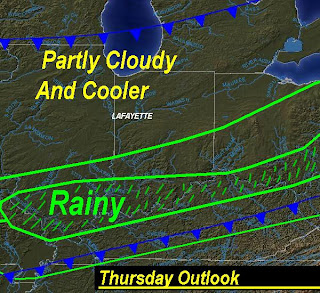
Now above is Today's outlook and this is just the picture! We will see the rainy stuff move out and the Partly Cloudy move in! Yes, the rain is pushing off to our east and the cooler weather will come in as well. It is looking like a great week however just a little drop in temperatures! Nothing major or bitter cold like we have seen this past few days but still we will feel it after having the past few days in the upper 60s to low 70s we all love so much..........We will see our high temperatures today in the mid to upper 50s and tomorrow highs in the mid to upper 40s with get this a low in the upper 20s! Good news is this won't last long with another slight warm up coming by Monday. Along with our next chance for some real rain and maybe a thunderstorm. I will watch this and keep you posted as it gets closer.My aunt Bomber sent me this picture of her Chihuahua Sophie last night and she calls her the taco Sophie lol. I think it is safe to say that Sophie is a little wore out after a full day of FUN and running all over that big yard she has! It is a Chihuahua's Dream! :) Thanks Bomber for sending me that GREAT picture! Be sure to tell Sophie she is looking good and to keep the pictures coming!!! ;)

Well, I do think we will see more of the nice weather we had this past week just a little cooler. So for the rest of this week I think it is a Partly cloudy forecast and we will be talking about more rain and a possible stray thunderstorm by the start of next week..........

Wednesday, March 18, 2009

UPDATE AS OF 6:00PM FOR THE BETTER!!

OK here is the latest! By looking at the radars and watching them closely we in the Lafayette areas look to be missing out on the heavy rains tonight! Again this is great news for our area rivers. We will still see a few light rain showers but I'M not even seeing anything heavy for Lafayette at this time.

Areas on Montgomery, county will see the heavy rains off and on this evening as well as a few thunder rumbles possible. I have been picking up lightning strikes in the south part of our great state around Indianapolis IN, and south. This is again where they will see the heaviest rains and the thunder. Even for these parts nothing is severe. Which is more good news!

So any rain for the Lafayette area should stay on the lighter side with less then a quarter inch!

I will check in if needed. For once we miss out with a nice gift from nature!! ;)

The Rain Is Getting Closer

The rain is getting closer as i type but the good news is it is looking like a hit and miss shower more like scattered showers through out this evening! Take a look at our local radar below you can see the rain showers are getting closer as they are currently in the Remington, area of Jasper County.There is a little more rain on the north west side of this line however the good news is we will not see anything severe and just some light to Moderate rain showers. Here is the look at the Satellite Radar image below.
So we will be a little wet as we keep heading into this evening as the clouds are starting to move in as seen above! Also by the looks of things I think keeping the expected rainfall around that quarter inch mark is best at this time which is more good news for our area rivers! I'm picking up a few lightning strikes but they are few and far between. Still with that said I would now rule out maybe a rumble or two but nothing more at this time. Keep dry and I will pop in if needed. Be sure to send in pictures if you can and also rainfall totals! I will see you soon..........

A Beautiful St. Patrick's Day It Was. Now What Does Nature Have For Us?

Take a look above at that high we seen yesterday for our St. Patrick's Day Cookout. Yes, I made the Hot dogs and Hamburgers you see above for my Family and everybody seemed to love them. Just a good old cookout and this was the best weather to do so in. You see that high of 74* degrees Lafayette seen and not a cloud in sight other then a few contrail clouds from the high flying Jets. I even got some extra time to get out and talk with some of our neighbors and my neighbor is so sweet. I was out in the yard and she came walking down with some cupcakes in her hand. She yelled for me to come over and gave us some St. Patrick's Day goodies. She is in her 80s and we always watch out for her like she is our family! She is a good lady and one of the nicest people you would ever want to meet. We both watch out for one another and I think that is just great! Well, all us Bloggers and weather watchers where not the only ones enjoying the wonderful weather out their yesterday! That's right all the dogs wanted to get out and run around. After words they where pooped. Take a look below.Yes, that is my sisters Chihuahua Willie. He is a HAM in front of the camera as you can tell lol. He was out all day yesterday just loving that warm fresh air and came in still pumped up and playful. He is a doll! If only you seen him in person you would know what I'M talking about lol. This little guy has a BIG personality and is just like a little kid! Just looking at that picture tells you he is a handful! lol.

Well, after that nice weather we seen this past week what does nature have to give us today? Well, I have your answer and it is rain!

Yes, we are looking for rain on the radars after tracking all that Partly cloudy last week! I do think we will start the day out rather dry until we start to get into the afternoon after 2:pm closer to 3:pm the rain will then start to move in. Currently I like rainfall around a Quarter inch. Still we will watch the rainfall closely as the rivers are currently at 15.31ft which is still a good 4ft above flood stage. Now currently we are not expected to rise much at all but if we see the rainfall reach the half inch to three quarters of an inch then we will see the rivers start to rise slightly. But again I still currently think we will see rainfall closer to that quarter inch mark. This will be better news for the rivers. The ground already is wet enough so don't get me wrong but a quarter inch is better then three quarters of an inch right? ;) Another thing is I think we will miss out on the stronger storms this time around as I look for them to stay to our south. Closer to Indianapolis and south of I70. Now I still would not rule out a few rumbles today but nothing severe!And we will start to fall in temperatures slightly again after this cold front pushes through our area today as you see in the map I have put together above. Yes we will fall to some temperatures in the mid 40s as a high only to start warming once again by this weekend. It is that time of year again where we go up and down. I do know one thing is for sure! The 70s we seen yesterday really felt like a mini heat wave in the 80s! Maybe this was just me lol. I did enjoy it and I'M loving this nice weather.

Well, all have your rain gauges up and ready to go today and be sure to post your rainfall totals. And if you have any pictures be sure to send them in! Weather pictures are always good ;) Have a great day and I will catch you later with an update if needed! Now I need to get some rest have a good one....................
5 Day Quick Cast Blog Cast..........

Tuesday, March 17, 2009

Happy St, Patrick's day!.....Is Rain On The Way?

Quick Cast Blog Cast....................

Today. We will see another GREAT day with highs in the 70s!!!!! This will be a great day to get out and enjoy the nice skies! Yes, you may want to grab your shovel and start scooping the Partly cloudy out of your driveway! Winds will be light between 15 and 20 mph. Lows in the low 50s.

Wednesday. Another day with highs right around 70* degrees however not so Partly cloudy. More of Light rain showers starting in the afternoon. Currently I don't see thunderstorms however there is a real slight chance we could see a few rumbles but NO nothing severe. Rainfall looks between a quarter and a half inch possible. Winds will be slightly higher between 15 and 25 mph with a few gusts to 30 35 mph. Lows in the mid to upper 40s.

Thursday. A little cooler with highs in the mid 50s and a off and on sun. Lows will drop to the low 30 to upper 20s.

Extended Outlook. Friday will be cool with highs in the 40s and Partly cloudy to Mostly sunny skies only to have more rain showers move in by the weekend. Currently Saturday is looking Partly to Mostly cloudy with a stray shower that night possible into Sunday..........
-------------------------------------------------
-------------------------------------------------
-------------------------------------------------
Hey there Bloggers!!!!! First things first I wanted to point out to all you morning readers that fog is possible this morning as you head out. This is because we are seeing the Dew points and temperatures get closer together as the night is going on. As this happens along with a light wind our fog chances go up! Let me remind you that fog can be hard to forecast. This is because dew points are almost impossible to forecast. You just have to keep looking at the current data maps and look at past data. So with the chance for fog allow yourself some extra time and drive safely!

We seen a great day yesterday with mostly clear skies and a high of 69* degrees. Well, I have good news for warm weather lovers! Yes, we will see highs today in the 70s! I think we could push 73* degrees today! How does that sound?? This will go along great with the Partly cloudy we will see.

No this wont last for long as we have another cool down that will come and this cold front will bring some rain showers along with it for our Wednesday! Take a look at this map I have made below.Now I do see the rain coming back in the forecast by Wednesday however as for storms I will keep that a slight chance. No not severe this time which is great news. However I will keep the chance for a few rumbles possible. Rainfall is looking between a quarter and a half inch possible. As of now I would look for the rain to start in the afternoon sometime around 2:pm or just after. Some gusty winds will be likely in the morning between 6:am and 11:am with a few possible gusts to 30 or 35 mph at times. Otherwise we can look for winds to be between 15 and 25 mph.
And that's right it is St, Patrick's Day!!!!! It could not be any better weather for this Green day! Be sure to wear something green today or be ready to get pinched by your little ones! I learned the hard way by having a big sister! I think you know what I mean LOL ;)

Enjoy your day today and We will again time everything out for you here later on tonight or just when we can expect the rain tomorrow. Be sure to check back real soon..........As we all know in Indiana the timing today will not be tomorrow! :o) Have a good one. By the way.......... I got Ya PINCH PINCH PINCH! ;)

Monday, March 16, 2009

We Will Push 70* This Week With Rain Back In The Forecast?

Hey I'M just checking in with your Quick forecast for the next few days! It was a GREAT weekend and we got a lot of work done outside.....Yard work and cleaning that is! That has got to be the only bad thing about winter is the clean up after.....Otherwise it is beautiful but spring cleaning is a pain LOL.....But it has to be done!

One thing I like to say is "Every job has to be done and it has to be done well"

Here is your Quick Cast below. I will check it here again with you all again later on tonight and we will start the work week right! ;) So go make it a GREAT START TO MONDAY!!!!!

Quick Cast Blog Cast..............................

Monday. We will look for highs today right in the upper 50s to low 60s with AM Clouds and PM Sun.....Clouds as we wake up but I think we will start to see the skies clear out a bit as we head into this afternoon to evening. Winds will be light and calm between 3 and 5 mph. Lows in the upper 30s to low 40s.

Tuesday. Highs will be in the mid 60s with another day of Partly cloudy skies. Winds will be slightly higher through the day between 5 and 10 mph. As we head into the night we will see the winds start to pick up a bit after midnight gusting to 35 maybe even 40 mph at times. Good news is we should start to see the winds die down as we head into early Wednesday morning..... Lows in the mid 40s.

Wednesday. Showers / Few Thundershowers are possible. I do see rain back in the forecast here on Wednesday and it currently looks to be between a Quarter to a Half inch possible. It will be a mostly rain event with the chance we could hear a few light rumbles but you should not fear I DON'T see anything severe! Highs will be in the upper 60s to low 70s. And lows in the low to mid 40s.

Extended Outlook. We will feel slightly cooler then what we have been this past week with highs in the mid 40s to mid to upper 50s range. Partly cloudy skies for Thursday and Friday. With more chances for rain later on next week....................

Sunday, March 15, 2009

It's Severe Weather Preparedness Week While We Enjoy Another Nice Day And The Rest Of Our Weekend!!

Hey there I know it's the weekend and most are out enjoying this nice weather as you should be LOL. But I Just thought I would check in real quick with this post reminding you all that Severe weather preparedness week is starting between now and the 21st to better educate people about the hazards of severe Thunderstorms and Tornadoes and to be ready should any severe weather occur.

And I wanted to remind you all to get out and enjoy this nice weather we have had this weekend! It has been beautiful! I may have to get out and help my grandma work out in the yard today! Some fresh air will do us all some good. ;) Have a great day enjoy the rest of your weekend!

Here is all you need to know about the severe weather preparedness week I have posted below..........Again have a great weekend and I will see you all soon..........


Severe Weather Preparedness Week: March 15-21, 2009


Governor Mitch Daniels has proclaimed March 15 through 21, 2009 as Severe Weather Preparedness Week in Indiana.

The National Weather Service, in conjunction with the Indiana State Police, the Indiana Department of Homeland Security, the Indiana Department of Education, the Indiana Broadcasters Association, the American Red Cross, and Amateur Radio Operators will conduct a statewide test of communication systems on Wednesday, March 18 between 10:00 AM and 10:30 AM EDT and between 7:00 PM and 7:30 PM EDT.

The goal of Severe Weather Preparedness Week is to better educate people about the hazards of severe thunderstorms and tornadoes, and to help everyone be prepared should severe weather occur. Each day will focus on a different topic:

Sunday: Kick-Off: Discuss Partners' roles in Severe Weather


Monday: Severe Weather Outlook: Partners' roles at the Outlook stage of an event

Tuesday: Watch: Partners' roles in the Watch stage of an event

Wednesday: Everyone's roles in Warnings

Thursday: Response: Partners' roles in responding to disasters (real-time response)
Friday: Recovery: Partners' roles in the recovery process (days/weeks/months after disaster)

Saturday: Wrap-Up: Importance of preparedness and action during threatening hazards