Friday, July 24, 2009

Weather Update And A New Server!! Thank You Bloggers For Everything!!

Lets take a quick look at the weather outlook for later on Tonight into Saturday morning.... We do have some Scattered rain chances as well as a few thunderstorms cannot be ruled out.. Tonight we have a really slight chance at some really light scattered hit and miss showers. Anything tonight would be later on After Midnight and only around a Tenth inch or less. However as we head into Saturday morning early we will see some more widespread scattered shower over take the area as they form along a cold front.
You can see in this map I put together for you all above. Once that cold front makes a move on us by tomorrow we will see more showers develop along side it. The good news is that at this time we are not expecting it to really become well developed until in moves off to our east! This is when things have a better chance at becoming severe. As for tomorrow we will see some scattered thunderstorms across the area. Not currently looking for anything severe however we may wake up to some thunder. The reason I'M not looking for anything severe at this time is because we are rather stable at this time. Our Lifted index outlook (LI) is only expected to fall to around -1.70 to maybe -2.00 by time the front moves in. As some of you already know you usually need a Lifted index of around -4.00 and lower for things to really become severe!

Forecast Tip..... Lifted Index is used to show how stable the atmosphere is or is going to be at a certain time.

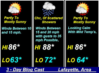
As far as rainfall goes for Saturday! I think we will keep it anywhere between a Tenth inch to a possible quarter in area. As always with locally higher amounts possible with thunderstorms.....
~~~~~~~~~~~~~~~~~~~~~~~~~~~~~~~~~~~

Well, as you all know this is the last post on this weather blog! Yes, this blog is going to become retired! I will still keep it on however there will not be anymore updates to this blog. If you would still like to follow my Indiana Weather Blog then be sure to bookmark this link below.

http://www.jiwb4.wordpress.com/

http://www.jiwb4.wordpress.com/ This is the new Justin's Indiana Weather Blog server..... I will be keeping this site updated from now on! And with rain on the way tomorrow be sure to bookmark it! lol.... I cannot wait to see you all there! I REALLY hope you all like it..... It is a little different however I think we all can get use to it! ;) Thank you all SOOOOOOO MUCH for all your WONDERFUL SUPPORT!!!!
http://www.jiwb4.wordpress.com/

http://www.jiwb4.wordpress.com/

Off To Wordpress We Go..... ;)

OK! If you all are happy with Wordpress then I shall be back here in a few with an update on your weather forecast as well as the link to the new blog server!

Thanks for ALL your support!!!! You guys and girls are the BEST! ;) I know you will love the new server. Nothing is changing other then the server! You all can still e-mail me your weather pictures at storm18mini@aol.com and I shall post them.... We can still talk on the blog just like we do here! You can post fast in storms with no problems.... and best of all!!!! No rude Bloggers! lol........

I will check back real soon.....

Thanks again.

Tank you fellow Bloggers!! The BEST IN THE WORLD!!

That is AMAZING!! Everyone! I can truly say that I had no idea how much this blog means to all of you! Really I had no idea how many read this blog! After reading all your WONDERFUL comments I cannot leave you all hanging..... So you all tell me what you think of this idea I had!

I found out about wordpress, from one of our bloggers Brow. Wordpress is something you all already use by people like Mike Prangley when he had his WLFI blog! It is simple to use.... The reason I would switch to wordpress is because it has a great comment control on it! You all will be able to comment without having to sign up for anything!! Which I know a lot of people don't like to do! This would stop all rude comments from getting through........

Would you all be ok with this???? The weather page would still be up! And wordpress is still a Weather Blog that I post on just like I do on here.... I'M trying to make it as close to this as possible. This would not be a MAJOR change. I just want to know if you all would be ok with this and still follow my blog?!?!

Again let me know in comments.... Until I would have the other blog up and going this will be our main blog.

Thank you EVERYONE!!!! ;) I will check back.

Thursday, July 23, 2009

This Blog Is Coming To An End.... Thanks For All Your Support!

Well, as you can see the sky's look as though they will try and clear out a little bit today before to long! I do think we keep today mostly dry for the most part.... Still right now as the morning goes on we are still trying to get these crazy clouds out of our area lol. So what about the rain everyone is talking about for today?? Well I shall get right to it! Take a look below.You can see that the main thing causing the possibility for some light scattered rain showers today will be that low pressure system to our north and east.... This is what may spin out a few light scattered showers from the north. Still we are only going to give this around a 30% to 40% chance. This would be later on this evening..... Not looking for much this time around.... Rainfall looking around a tenth inch.

Now I have something I would like to fill you all in on.... I love this Blog and I love my Bloggers as well as keeping you all updated the best way I can in and out of storms. It has been a wonderful three years on weather blogs for me however it is getting close to ending this weather blog. This is a Weather blog and a fun talking blog for people to come and enjoy. This is not a place that I put together for everyone to come a fight over the weather! The weather is not something that one can even fight about!! Really!! I read all the comment that get posted and I just wanted to say that I'M in NO competition with ANYONE. I just post my thoughts on the weather and I always hoped it helped you all as well.

All these Anonymous posters starting things / fights over weathermen is also pointless..... In case you all want to know why I talk about Mike Prangley,on this blog more then I do Chad evens, it is simply because I know Mike and he has helped me SO MUCH when it comes to weather!!! I have known him a long time and I have talked and seen him many more times. I have never said anything bad about Chad, and I'M not going to.... He has not done anything.. I just don't know him as well. As for if Mike is better then Chad or Chad better them Mike, It does not matter!!!! Everyone does the forecast a different way. Some better then others. It happens! But it is nothing to go wild over. I'M just getting tired of watching people go at it over something like weather and weathermen. That is not what I made this blog for and it is not what I wanted. All these people commenting anonymous and saying bad / rude things to hurt other people, it is nothing but childish play.. Lets all grow up and let it be... This is the reason this blog is coming to an end! I do thank you all for supporting me over all this time. But when it comes to fighting over the weather!! Lets don't do it.......... I started this blog without having to! Just because I wanted to. I get nothing out of it other then to read your comments! Which I love doing. But not when they are rude and childish.... Please in the future be kinder and nicer to people!!

One Act Of Random Kindness Can Change The World.

If you all really want this blog to continue then there is only one other thing I can do!! And that is make it so everyone who wants to post has to have a blogger ID..... This is very simple to do!

It is all up to you! Thank you for everything!! Please let me know in the comments..... ;]

I will check back soon.... It is not over yet!

Wednesday, July 22, 2009

Low Staying South Keeps The Heavy Rain With It!!!

This is the set up I was talking about in my last post! This low pressure system has set up more to our south then it was showing us a few days ago. And now it has set up a few more miles south then first expected. This has kept more of the heavy rainfall totals to our south once again.. We did have the rainfall amounts right on the money which I'M proud of lol. It is just that they stayed around boon, county and south.... This is where they had that .25" to .30" inches we talked about and called for last night. That is what happens when the low sets up a few 100 miles south.

Still I'M going to keep us in around a 20% to 30% chance at some light scattered off and on showers today however nothing heavy and no thunderstorms to worry about.... Strong that is anyway! I'M not looking for much this time around.. Good news is if you are planing to do some work outside today it will be nice and cool again with highs in the low to middle 70s. Not bad not bad at all..........

I will check back if there are any more major changes in the weather.... This is the main reason I will NOT use those Radar Image models that show what the radar should look like at a given time. I have found that they are wrong to many many times.... It is always much better to not only go with the weather models but also your gut!

I will check back....................

We Need Rain And Here It Comes.

The rain is coming back and we could use some! Yes, I have been watching for some rain to return to our forecast for some time now and today could be the day lol. Yesterday we was looking at some possible higher rainfall amounts closer to three quarters of an inch however today is a slightly different story! And this is the reason I never make a final call until the latest models come in.... Because models change all the time! Well, today we are now watching this Low pressure system set up farther south then it was yesterday! This means that it will keep the heaviest of the rain also to our south..... Yes, this low pressure will have a lot of moisture with it as areas from Indianapolis, south could be looking for rainfall anywhere between an Inch to an inch and three quarters possible!! We on the other hand will be looking for rainfall less then this between .25" inches to a possible .30" inches as seen in this map I put together for you all below.You can see we are again expecting to be BELOW average on our high temperatures and even our low temperatures..... Today's high is expected to be around 77* degrees. Our average temperature for this time of year is around 87* degrees!!!! This means we are going to be around a good Ten degrees below average!!!! Even on Thursday we will again be around Seven degrees below average!! The record high set on this very day back in 1983 was of a whopping 105* degrees!!!!! I don't see us getting anywhere near this today!! lol.....

We will see more calm winds between 10 and 15 mph as well as on Thursday between 10 and 15 mph. I will be checking back in today as needed! I see nothing severe AT ALL!!!! Which is always great news. However a small rumble of thunder will never be ruled out! We will be able to relax and enjoy the Summer rain hitting the window!

I'M going to go hang with my family!! I will check back soon....................

Tuesday, July 21, 2009

Many Pictures To Show You All While Rain Is On The Way!!

Hellooooooooooo Bloggers!!!! It is yet another wonderful start to the work week! We have had many mild to cool days and more mild days to come! Also we have some rain back in the forecast by as soon as later on tonight! However I will get to that in just a minute..... First off I said I would post some pictures from the Zoo Run Run this year and I shall do so! Well, here they are below.....This picture I took just after my Aunt Bomber, as we call her and my Sis CJ, finished the Race! You can see my Aunt being silly! lol..... Or was she???? Hummmmmmmm She did just walk three miles! lol :) Here is a better picture of them both below.This was a great time we all had and I'M very proud of my sister for being able to go the full three miles! She is such strong minded and will never says never! She will give it her all + some! She never gives anything under 110% I have to say I always have and always will look up to her! And every time I passed them while running the race she and my aunt cheered lol. I have no idea why?!?! :) but they had fun.....One of my favorite things about the race had to be the WONDERFUL water people! lol..... After a three mile race water tasted sooooooooooo good Ha Ha.. As you can see above they had a hard time keeping up with all the Runners out there. You figure over 500 people!!!! WOW they needed a lot Oh water!! :)Now how about the weather outlook???? Well, here it is!

I think today we will keep it mostly dry with some Partly cloudy skies over the WLFI viewing area........ Highs will be in the upper 70s to low 80s around 80* degrees. Lows still mild around 60* degrees possible. We will keep the winds light and calm between 5 and 10 mph with some more clouds moving in by later on this evening / tonight. Also we will see some rain possible later on tonight mainly into Wednesday morning / afternoon.

Tomorrow / Wednesday is when we will see even more rainfall across the area with scattered rain showers moving in along with this Low pressure system. We will be looking for rainfall anywhere between a quarter inch to a half inch possible with still some possible locally higher amounts to three quarters of an inch not being able to rule out. Highs will be in the middle to upper 70s around 78 degrees possible and lows still cool in the upper 50s around 59* degrees. Winds will be moderate between 20 and 25 mph. We will see the rain let up closer to that evening.......... I will have more updates on this later as we continue to get closer! (You can count on that) ;]

Now I did want to show you all this as I thought you might like to see this! Or find it kinda cool..... Check this out below....................


POSSIBLE IMPACT EVENT ON JUPITER: Did something just hit Jupiter? On July 19th, a black "scar" appeared in Jupiter's clouds similar to the Shoemaker-Levy 9 impacts of 1994. Veteran Jupiter observer Anthony Wesley photographed the feature from his observatory in Murrumbateman, Australia:"The jet-black mark is near Jupiter's south pole (south is up in the image)," says Wesley. "I have imagery of that same location from two nights earlier without the impact mark, so this is a very recent event. The material has already begun to spread out in a fan shape on one side, and should be rapidly pulled apart by the fast jetstream winds. I recorded a lot of footage, and will be generating more images and a rotation animation soon."

JUPITER UPDATE: New imagery of Jupiter from NASA's Infrared Telescope Facility in Hawaii suggests that something did indeed hit Jupiter. "It could be the impact of a comet, but we don't know for sure yet," says Glenn Orton, a planetary scientist at JPL. [more]

Alright Bloggers! I will check back real soon with more on your weather update coming here to the Indiana Weather Blog.......... Be sure to check back soon..... ;]

Sunday, July 19, 2009

Cool Weather Again Today

Hey everyone!! Boy oh boy it has been a great weekend so far!! The 5K Zoo Run Run was AMAZING! there was over 500 people and they all where having a great time. I will go back next year for sure! I have many pictures I cannot wait to show you all.... Which I will have posted on here real soon. Here is one quick picture of my Sister CJ and I getting ready to head out to the race! "We are not really morning people" LOL..We did perk up in time lol.... Well, when your running three miles it does wake you up pretty fast! Mike Prangley, tells me that when the Zoo Run Run first started they only had around 90 people! And this year there was a little over 500!!!! WOW!!!!

Well, I will have more on this posted real soon. Until then here is just the quick outlook on today's weather.

Today I think we will see these mostly cloudy skies with around a 20% chance at some really really light showers scattered across the area. Nothing will be heavy at all. If we see any it would only be around a tenth inch or less. Highs today are only going to reach into the upper 60s to LOW 70s.... So stay warm lol.

I will check back soon....................

Friday, July 17, 2009

**So Many Wonderful Things In One Day**

Well, HELLOOOOOOOOOOOOOOOOOO Bloggers!!!!! It was a wonderful day yesterday for many reasons!!!! First off I did finally get my stitches out of my finger after a long 10 to 12 days of having them in. It is a good thing that I got them out now do to the fact that I was starting to forget that I had them in if you know what I mean???? They came out really easy with no hurt in the least bit! Which is ALWAYS good for me lol..... Then we came back and My sis got back home today after staying a week out with my Aunt! Usually brother and sister don't get along to well however my sis and I are close! Which I think is great!

To finish a wonderful day, We started up the grill and had a nice little BBQ!!!! Now who don't like a good summer BBQ???? lol. Let me just say that you have not had chicken until you have had my Dad's Honey BBQ chicken! Just take a LOOOONNNNNGGGGG look at this picture below and your mouth will water! lol :)That I think it is safe to say that this was the BEST dinner I have had in a long time lol..... However I like pretty much anything BBQ. Ha Ha ..... It was a great day! As you can tell I'M in a good mood! :]

Also good news is the shuttle finally got to launch into space the other day after six long hard tries!!!! My Parakeet and I watched it go up into space on TV.. However I really don't think he cared to much :) Take a look at this below.....SPACE SHUTTLE ENDEAVOUR: It's official. Six times is the charm. Space shuttle Endeavour roared into space from the Kennedy Space Center on July 15th. It was the shuttle's sixth attempt to launch since mid-June, earlier liftoffs having been foiled by hydrogen leaks and bad weather. The shuttle is on a mission to deliver a new crew member and a "space porch" to the International Space Station (ISS).
About 20 minutes after launch, the shuttle and its external fuel tank streaked over Ireland:
"It was the most memorable thing I have ever seen!" says photographer James Adamson of County Mayo. "The two bright star-like objects were almost as bright as the ISS--one bright white and the other deep orange. I took the picture using my Nikon D40." Endeavour is now in orbit heading for a Friday rendezvous with the ISS. On July 17th and 18th, the two spaceships will appear side by side in the night sky in an "amazing" arrangement akin to the shuttle-fuel tank combo Adamson witnessed. Stay tuned to the Simple Satellite Tracker for predictions.
~~~~~~~~~~~~~~~~~~~~~~~~~~~~~~~~~~~~~~
~~~~~~~~~~~~~~~~~~~~~~~~~~~~~~~~~~~~~~


Now after looking at that amazing picture!!!! WOW it just makes you wish you could have seen it live in person! I have never done that however that would be amazing to see..... Now it is time for the Quick Cast Blog Cast..........


Today we may wake with some mostly cloudy skies and still some really light scattered rain showers in areas this early early morning..... Then as we head into the main part of the day we will start to see things clear up a bit and become Partly cloudy across the area. Highs are going to be mild in the upper 70s to low 80s possible with lows falling into the lower 50s!!!! This is well below average!! Winds will be calm between 10 and 20 mph.....

Saturday will be cooler yet! We are going to see our temperatures fall well below average for both highs and lows once again with highs only reaching into the low 70s!! Can you believe it?? And lows again into the lower 50s!! On average we should be looking at our highs in the middle to upper 80s around 87* degrees! and our average lows are usually around the middle 60s close to 65* degrees!! You can see what I'M talking about..... Much cooler that is for sure! We will be looking for our winds to again be rather light between 10 and 15 mph. Not bad at all..........

And last but not least the Zoo Run Run is coming up this Saturday!! Yes, this is going to be a great day to get out and enjoy the weather with a nice jog or walk! Be sure to get out and join the fun at the Zoo Run Run..... I will be there giving it my best shot to go the full 5K which is around 3.1 miles..... I just hope I finish and finish in a good place lol. Here is just a little info on the Zoo Run Run I have posted for you all below!

The 7th Annual Zoo Run Run 5K will take place Saturday, July 18 beginning at 8:30 a.m. Join the fun, and sign up today! Download a registration form below or register online at Active.com.All pre-registrants will receive a race t-shirt, one-day admission to Tropicanoe Cove, a delicious pancake breakfast, and the chance to win great prizes!

On Friday, July 17 from 6:00-8:00 p.m., join us for a Race Pre-Registration event! Get signed up for the 5K race, or if you've already signed up, pick up your race packet early! All attendees will be entered to win a $25 gift card to Wal-Mart (winner will be announced race morning)! Be sure to attend!

Have a wonderful Day bloggers! I will see you all at the Zoo Run Run!! And to all those heading out there this Saturday! (Good Luck) :] Oh one more thing before I forget! The poll is now closed on my Weather Page. I have now posted the right answer.... Be sure to check it out at http://justinsweatherpage.blogspot.com/ and see if you voted (Right)..........

I will check back soon.......... Thank you all for reading....................

Small Update

Hey Bloggers!! Still Up Tracking With Me???? LOL :]

The good news is the scattered thundershowers some of our northern counties are seeing is nothing severe!! We are seeing heavy rainfall at times and lightning however that would be the main threat! I'M not seeing our Echo tops getting any higher then around 30,000ft at the max which is good news!! Also we have no current watches or warnings in effect for this area! and we hope to keep it that way!

Scattered thundershowers possible?? Sure! We will see these tonight however I think we will clear up a bit and not wash out our day tomorrow / Friday! I will be back real soon with your MAIN BLOG POST so stay tuned! ;]

DEVELOPING....................

Wednesday, July 15, 2009

Back With The Update!

Ok I'M back with your outlook update! Yes, we did see those thunderstorms roll through our area early this morning and everyone got wet lol. Lafayette, picked up a quick 0.50" inches. Reminton, up in Jasper, county picked up around 0.19" inches of rain this morning. We may still see a few light light scattered showers however for the most part I think we will start to see a few breaks in the clouds here before to long! The worst looks to be over at this time and the NWS agrees with my forecast! As they have taken our area out of the slight risk for severe....

I will check back if needed otherwise see you all soon bloggers.

Go enjoy the day! ;]


~~~~~~~~~~~~~~~~~~~~~~~~~~~~
----------------------------------------------------

Hey Bloggers. I'M just ging to pop in real quick with a Quick Cast weather outlook. Let's get to it!!

Today we will be watching for a (Slight chance) at some more scattered thunderstorms possible. This forecast for today is going to be a little tricky! Here's why! We are going to be looking at CAPE values starting to rise later on. Our Lifted Index will drop to the -5 range. and we will see helicity go up to around 300 to 400 later on today as the day goes as well. The problem with this set up is even though we have all these unstable things taking place we still only have around a 40% chance at thunderstorms for today! This is going to be an off and on thing through out the day.... So right now with this set up we are in a Slight risk for severe weather however I'M going to check back after looking at some Skew-T's as well as more current data and then give you another final weather outlook for today!!!! Sound Good?? :] Now we will look for temperatures today to be in the middle to upper 80s around 88* degrees possible. and winds between 10 and 20 mph with gusts between 25 - 28 mph possible. Lows will fall only into the lower 60s.

Thursday is looking much better with less in the way of wild Indiana weather and more in the way of Partly cloudy to Mostly sunny skies through out the day. Highs will reach into the middle 80s with winds between 10 and 20 mph and becoming more light as the day continues. Lows will be again in the low to middle 60s possible.

Friday will be the next (Slight) Chance at some scattered rain. Now looking to likely at this time however that is still a few day away so we will fine tune that forecast as it gets closer!

I will check back here on the Indiana Weather Blog real soon today with another weather update on today's outlook once I go through more Current Data!

See you then....................

Tuesday, July 14, 2009

Clear Today With A Chance For Rain Tomorrow!

Well, it has been a nice start to the work week so far don't you think? Well, we have another nice day today before we talk about more possible rain showers tomorrow! But before we get into that! I did add another link to my newest weather page. As well as this weather Blog. Yes, it is my Follow Us On Twitter link. All you have to do is click on the link and there you are. I have had Twitter for a long time however I was having problems for some time and could not get it going for some odd reason? But now it is back working and going strong! With my Twitter you can check out some of what goes on when I'M not doing the weather forecast or the Blog post! There may be some weather stuff on there sometime however mostly just my spare time stuff! lol. I know some of my Blogger friends are already following! And thank you for that! ;]

And now back to your local forecast! Check out this map I have posted for you all below. Yes, this is your Quick Cast Blog Cast.You can see by the map above that today is looking like a nice Summer day with highs in the upper 80s and Partly cloudy to Mostly sunny skies through out the day! To make it better the winds will be light again today between 10 and 15 mph! Lows still mild in the lower 60s possible and we hold off on the rain chances until closer to Tomorrow.

Now at this time it is only around a 40% chance at some scattered showers across the area. As you already know I will have more updates on this chance of rain coming up soon. No severe thunderstorms are expected at this time which is great news for all of us! I know a lot of you would rather take a winter storm over a severe thunderstorm any day. I know I sure would!! Man Now I'M thinking about Winter weather tracking! lol. I have to remember it is still Summer and try not to get ahead of myself! LOL :) I just love Winter that much! Just like our use to be meteorologist Mike Prangley! Who is Truly missed! That man sure knows his weather that is for sure! I don't think anyone knows as much as he does Weather - wise that is!

And last but not least I wanted to have a quick little post about something everyone has been talking about! Well, some anyway! lol. Yes the STS-127. This shuttle has been delayed many times already do to bad weather conditions. It is now expected to launch on Wednesday July 15th at 6:03pm EDT. Here is a picture as well as a little info on this ready to go shuttle below..........Liftoff of space shuttle Endeavour on the STS-127 mission has been rescheduled for Wednesday, July 15 at 6:03 p.m. EDT.Monday's attempt was canceled due to poor weather conditions within the launch area at NASA's Kennedy Space Center in Florida. Anvil clouds and storm cells containing lightning flared up toward the end of the countdown, violating stringent launch safety rules."Technically, we've been really clean the last two days with our vehicle," Launch Integration Manager Mike Moses said of Endeavour's launch attempts on Sunday and Monday. "It's just been the weather scenario that got us."The outlook is better on Wednesday, with only a 40 percent chance of weather conditions prohibiting liftoff.

The 16-day mission will feature five spacewalks and complete construction of the Japan Aerospace Exploration Agency's Kibo laboratory. Astronauts will attach a platform to the outside of the Japanese module that will allow experiments to be exposed to space.

The STS-127 crew members are Commander Mark Polansky, Pilot Doug Hurley and Mission Specialists Dave Wolf, Christopher Cassidy, Tom Marshburn, Tim Kopra and Canadian Space Agency astronaut Julie Payette. Kopra will join the space station crew and replace Japanese astronaut Koichi Wakata. Wakata will return to Earth on Endeavour to conclude a three-month stay at the station.

Good luck to all these men and women on there mission in space this week. God bless them and pray they come back home safe and sound! Good luck everyone. Bloggers have a wonderful day.......... I will check back soon....................

Sunday, July 12, 2009

Amazing Rain!

Well, it looks as though we did miss out on the severe weather!!!! Thank goodness! We in the Lafayette, area did however see some brief heavy downpours at times but as we head more to our north in our northern counties like Newton, Benton, and Jasper, They seen little to none! What a difference a few miles can make. Lafayette, had a final rainfall total of 0.50" Inches! You can see that once the cold front moved over our area we seen more of those widespread showers over take much of the southern parts of the WLFI viewing area. Take a look below. This is how things looked on my Doppler Radar at around 12:46pm yesterday afternoon.
Once that cold front moved in we was watching the scattered showers pop up every where. Whats so funny or cool about this is if we look closely at this radar image you can see that the rain showers just kinda "STOP" once they get about half way in Benton, county! It really looks amazing! Nothing was severe which is good news. All the real heavy stuff did as we said in one of our older post, Stayed to our south and! Which is fine with us right? ;]

Now today I think we will keep it dry with Partly cloudy to mostly clear skies! Even better is the winds will be nice and light between 10 and 15 mph. Also I think we start out the work week dry as well. With more Partly cloudy skies and winds even lighter between 3 and 5 mph. It just don't get much better then this!

Until then I'M going to go enjoy the rest of my weekend as well as you all should! I will check back real soon. Have a GREAT weekend everyone....................

Saturday, July 11, 2009

**Update On Todays Weather Outlook**

Ok, Bloggers..... I have gone through the latest models and this is what things are looking like!

The cold front still has not passed over the area however the line of scattered thunderstorms have developed However it developed to the east of our viewing area! The reason we where calling for storms was because the models was showing this line possibly forming to our west which at this time has not happened. Still we will keep around a 40% chance at some scattered thundershowers to develop however I think our severe threat has gone way down! This is great news! I was starting to really go through the data last night and really wonder after I seen our Helicity was only looking to be around 150 to 200. Which as I said in my last post is weak! You need it to be around 400 to 500 to really have anything form over your area. Supercells and severe storms that is!

As for unstable today! We are currently looking at a Lifted Index of only -1 which is also not bad at all! Usually you need Lifted index to be around -4 and lower for severe thunderstorm development!

You can see in this image below how the main line is already passed over the area.WWe may see some rain today. Rainfall is looking to be around a Tenth inch to a Quarter inch with locally higher amounts possible with any thundershowers that could pop up..... Now if anything changes I will be back to let you know! Otherwise have a nice day Bloggers. We knew a line would form, It just formed a few more miles to our east then expected!

Thank you all for all the nice comments on my new site! I hope you all really like it! It makes it easier just in case I cannot update this blog. Then you still have a place to go for your local forecast!

Also for the "poll" I have on my new site, I will post the right answer after the poll closes! (Be sure to vote) I will check back soon..... ;]

Getting Ready For Some Scattered Thunderstorms Today.

Just popping in real quick because I will be popping in off and on through out the day as needed.

I just want to give you all a quick idea as to what we can expect weather - wise for today! We are going to be seeing these off and on scattered line of showers and thunderstorms through out much of the day! Right now it is looking like we will be capped through out this morning however as we head into the afternoon hours the cap is going to become weak and allow more storms to pop up. We are in a slight risk for severe weather however I still look for the worst to stay south. still we will not rule out a stray strong storm just yet as that is still possible. Good news is right now the models are showing our helicity only around 150 to 200 which is not to bad. Let me point out that helicity is used to find where the rotation would be needed to form severe thunderstorms as well as super cells. Usually you need our helicity to be around 400 to 500 to form severe super cells.

We can look for rainfall in these storms between a quarter inch and a half inch possible as this cold front pushes through the area. Winds will be between 15 and 20 mph. Not to bad.....

I will be checking in through out the day as needed with in storm updates!!

Friday, July 10, 2009

Update On Your Weather Outlook

Well, we have been watching the radar's all morning and watching that rainfall to our north and west in the state of IL. This rain / thunderstorms has been weakening which is great news however we are still looking for some scattered thunderstorms to move into the area later on tonight and then mainly Saturday! This is a map I just put together to show how things are expected to look by 8:00AM tomorrow / Saturday. But first what about today? Well, I do still think we keep a 40% chance at some scattered thundershowers later on this evening / Into tonight however I still look for the better chance at some scattered to moderate thunderstorms on Saturday where we will also have the better chance at some locally heavy rainfall amounts. Currently I'M looking at rainfall amounts for tomorrow between a quarter and a half inch possible with as I said locally higher amounts possible in some areas.

Now for today extreme western parts of our state is in the slight risk for severe however again Tomorrow much of the state will be watched as that cold front tries to make its move on us!

I will check back again later on this evening if anything is to change! Have a good day Bloggers. I'M off to get some work done real fast! ;]

Starting Out Nice With Possible Storms On The Way Later.

Well, Today we are going to start out with some Partly cloudy skies however it won't last for long with some rain / Scattered T-storms on the way later on this evening / Tonight possible! Currently there is a slight chance that a few storms could become severe however I will not make that my final call until I get a few more model runs in! But for not we will not rule some out!

I have to go do some yard work for a neighbor today then I will be back with another update on our weather for tonight! Also I put in the link to my weather page on the side panel just to the top right on my blog.... I will pop back later on today.....

Be sure to check back.

Thursday, July 9, 2009

Making This Blog Better With Another Indiana Weather Website!

Well, Hey There!!
I have not only been working on your forecast but also something I think a lot of you will enjoy! Yes, in my free time I have been working on my very own Weather Web Page! Now it is not totally finished however for now it looks pretty good! Here is the link to it below. Yes, my weather blog will still be up and going however this site will come in handy for your forecast if I cannot be on here! Which I plan to be! ;] Still here is the link below.

Justin's Indiana Weather Page.
http://justinsweatherpage.blogspot.com/
~~~~~~~~~~~~~~~~~~~~~~~~~~~~~~~~~~

I hope you all like it and find it helpful as well. Please feel free to comment on that site and let me know what you all think! Thanks for your support! As always!
Now lets take a quick look at the Three day forecast above! You can see we are looking good today with lots of mostly clear skies and highs in the middle to upper 80s. Lows also mild in the lower 60s. Tomorrow however is when things will be watched! We will start out the day with some Partly cloudy skies however as we head into that afternoon / evening we will start to see more clouds try and roll into the WLFI viewing area. Later on that night we will be tracking some more widespread scattered thunderstorms possible. Now currently it is looking like the heaviest of rainfall and storms would stay to the north of the viewing area. However this is a day away so I will have more on this here on the Indiana Weather Blog tomorrow! So be sure to check back soon..... Then as we head into Saturday we may still see some leaf over scattered off and on thundershowers possible. But as for anything severe for Friday night! Currently it is not looking severe over our area however it is still to far away to really call it! And you all know I like to have a few more weather model runs before I go all in on a forecast! ;)

Have a good one Bloggers. Don't forget to check out the site! http://www.justinsweatherpage.blogspot.com/ I will have a link to my new site posted on the blogger side panel just to the right here real soon.

I will check back with more weather outlooks soon....................

Wednesday, July 8, 2009

Quick Cast Blog Cast.......... More Rain To Talk About?

Just checking in with your quick cast blog cast for today and Thursday's weather outlook!! We did see our little bit of rain yesterday evening however it was light and scattered few and far between! I'M really sorry about these short quick blog post this week however I thank you for sticking with me! Really! Now lets get to your forecast!
Today we are looking for some more scattered rain showers across the area. However scattered is the key word in this forecast! Not everyone will see rain! Now as we head into the evening / night time hours we will have a slightly better chance at some rain showers with some thunder not ruled out just yet! This will be nothing severe so no worries there! ;] Temperatures will be mild in the low 80s once again.

Thursday we are looking at some possible left over showers in the early early morning hours however as we head into the late morning as well as that afternoon we will start to notice the sky clearing up and becoming more Partly cloudy across he WLFI viewing area! This will make for a wonderful Summer day! With highs looking to be in the middle to upper 80s.
~~~~~~~~~~~~~~~~~~~~~~~
~~~~~~~~~~~~~~~~~~~~~~~
Above is a look at today's Prog Chart. You can see that the reason for this slow moving pop up rainfall is because of this stalling front over our area. Once this front passes by Thursday we will start to dry out and look much better! I think after today / tonight we will keep it dry for the rest of this week. However our next chance st some more possible rainfall to move into our area will be closer to this weekend! We will talk a little more about that as it gets closer!

Until then I'M going to go get some sleep! I will check back soon..........

Thanks Again! Weather Bloggers ROCK! ;]

Tuesday, July 7, 2009

Chance At Some Light Rain However Not A Total Washout!

Hey everyone. Thank you all for understanding and allowing me time to get better. Right now I'M in a little pain but doing ok!! However I did want to check in with just a few quick things!!

First off today we are looking for some Partly cloudy skies however we are not going to rule out the slight chance at some light scattered rain showers later on this afternoon / evening. And then into Wednesday! Nothing strong or severe. A few rumbles are still possible however not a major washout or heavy downpours. And remember this is a slight chance around 30% to 40% chance. Still I'M here to let you all know what I know ahead of time Just in case! ;)
~~~~~~~~~~~~~~~~~~~~~~~~~~~~~~~~~~~~
~~~~~~~~~~~~~~~~~~~~~~~~~~~~~~~~~~~~
Now to answer some questions from my last blog post, Yes, Memo's Play area was finished! LOL. My sister helped me get it done and he loves it!! Here is a quick picture below.
You can see it has lots of stick steeps and also a wooden swing! Everything is eatable and safe for Memo. Just in case your wondering why Memo, is not playing on it this is because it is past his bed time and he fell asleep! :) He is only 48 Days old and still very much a Baby!

I will check back the best I can if anything is to change weather - wise! Have a Great day Bloggers! I'M going to go rest!

See Ya Soon.................... AND THANKS AGAIN!!!! ;]

Monday, July 6, 2009

Slow Updates Because I'M A Dummy!! :)

Hey Bloggers....
I'm sorry to say that blog updates are going to be short and few again this week! This is only because I'M having a hard time typing do to the fact I was out enjoying the nice weather yesterday and thought I would make my bird Memo, a little play area like most bird owners do or have. So while cutting a good size tree branch in half with a hand Saw (Not electric) thank goodness........ I came back and cut my finger. And no it could not be a little cut I might add!!!! lol it was big enough to make me run to the hospital and get three stitches!!!! Which I would do anything to get out of lol. But sometimes it has to be donw! Anyway it is looking better and I did no permanent damage!!!! Just need to give it time to heal! I will still try to pop in with short weather updates the best I can through out this week. Until then have a good Monday Bloggers and (Stay Safe) :)

Saturday, July 4, 2009

Don't Let The Rain Bring You Down!!!!

Well, bloggers it is starting to look like the weather models are going to hold true this time around and call for a WET July 4th firework show tonight! Yes, this rain has been going on through out the whole day and coming down moderate every now and then! It seems we have had rain just about every July 4th! Still people are shooting off there fireworks even at this time the rain does not seem to hold them back.... Just remember to take your umbrella along with you tonight!

Lafayette, has already picked up around a half inch 0.50" inches of rainfall up to this point. And much if not most of the WLFI viewing area could be looking for another quarter inch to a half inch possible by the time this rain passes closer to sometime after midnight. Here is a look at your timing map I have posted below!You can see we are expecting to keep this rain through out tonight however it may start to slow down a bit as we get closer to firework time! So once again a wet 4th of July it will be! Hang in there Bloggers and still make the most of this day! The good news is we are not looking for any storms or even Strong storms tonight which is GREAT news!!!! We will take good old rain over storms any day! The only fireworks we have to worry about tonight will be the ones you all shoot off! And remember, We are not sugar!!!! LOL We won't melt in the rain! Let me say the rain did not stop me from cooking out this afternoon! ;)

Have a good one bloggers! And (Stay Dry)

jd9380gh349swlwkdjsjjjjjjjjjjjjjjjjjjjjjjjjjjjjjjjjjjjjjjjjjjjjjjjjjjj (Memo, Be Careful :P) ;)

4th Of July Weekend Update! And A Look At The Newest Member Of The Family!!

HAPPY JULY 4TH BLOGGERS!!!!!!!!!!


Yes, it is a great day for America everybody!!!! Today is a great day to relax at home with your family and then get ready to fire up those grills as well as watch the fireworks! However if your lighting them off yourself then please be very careful and always be ready for anything! It is good to put the used fireworks in a bucket of water after shooting them. Also it is a good idea to have a garden hose by your side and ready to go just in case you need it! Don't let kids light fireworks, Always have an adult..........

And last but not least, Remember your neighbors when shooting off fireworks into the late hours!!!! Now before we go on anymore how about we look at your weekend forecast???? Or even better yet! How about we look at today's forecast! The 4th of July!!!!You can see above the timing map. Yes, we are expecting to see some rain showers today by as soon as later this Morning possible. Otherwise we will be seeing rainfall pretty much through out the day today! For the most part that is! Scattered however rainfall could get heavy at times with rainfall expected over the WLFI viewing area anywhere between a quarter to a half inch to locally higher amounts of a half inch to near one inch possible in places! You can see above we are currently expecting to see this rain try to push out before all the main fireworks really start! And I will check back later on today if anything changes! A few of natures fireworks cannot be ruled out just yet as a few thunder rumbles are possible inside this rainfall! However the good news is we are not expecting to see any severe at this time! Still we will as always in Indiana, "Keep Watch"

And last but not least!!!!! Here is a picture of our newest member of the Indiana Weather Blog below!

Yes, this is my new little Parakeet named "Memo" Off of the movie "Driven". He is a Rare Parakeet and is only around 45 days old! He has been our newest member for around five days now and he has come such a long way!!!! He is a really really smart little guy that is for sure! And he already has a morning routine! As you can see above he loves to sit on my finger as well as everywhere else! And also loves to sit by the window and watch the other birds play outside. And he has already made friends here at my house!!!! Yes, that's right we cannot forget about little Willie, the weather blog Chihuahua!Above is how he looked the day Memo, came home! He was amazed at him for the fact he has never seen a bird up close before! Willie, and Memo, play all the time. Well, if you call that picture above playing! lol. He really just loves to sit and watch! He would do this all night if we would let him. However they have to sleep sometime! :]

So there is our newest member! Maybe I should let him type on the Blog sometime?!?! Hummmmmmm.......... :] Well, if you ever see something like this "fhieuihensouvneheirn932503ufnqn'';,/,;,SDJNL" Then you know who it came from! LOL..........

Have a good one bloggers! I will post a new time map if needed! Until then have a happy 4th of July! And (Don't) shoot those fireworks off to late! You will scare Willie, and my Bird!!!!

Thursday, July 2, 2009

Fewer Blog Post's But No Slacking In Storms!!

Hey Bloggers. Sorry that I have not been doing as many updates on here as I usually do however as you all know things have been really busy this week! Just hang in there with me please! I will ALWAYS be here when possible whenever severe weather rolls through as well as leading up to the storm with many many updates!!!! We are a team and we will stick together!

How would you all like to meet the newest member of the Indiana Weather Blog team????

Well, I will check back real soon with the newest member and also we will talk about our wild Indiana weather forecast! When is our next possible chance at some rainfall???? What are our averages for this time of year and when will we be back to average???? All this coming up here on the Indiana Weather Blog soon. Also the 4th of July is almost here!!!! I will also take a look at that forecast for you! Will we get those fireworks in without rain for a change???? Check Back To Find Out!!

*********************
***********************
*************************
**************************
**************************
******BOOM**POP*******
********CRASH**********
************************
**********************
********************
((((((((((AMERICA))))))))))

Wednesday, July 1, 2009

Lots Of Work This Week Without Forgetting My Bloggers!!!!

QUICK CAST BLOG CAST..... 3 - DAY FORECAST.....

Today we will be looking for some light rain showers early this morning around a 40% chance do to this high pressure system well to our north we talked about yesterday! Again rainfall will be really light and scattered across the area.... This will also be bringing the cooler air along with it making it hard for our highs today to reach the low 70s. Winds will be rather calm around 15 to 20 mph.

Thursday we will be much different weather - wise. We will look for Partly cloudy skies over the area through out the day. Highs will still be cool in the low to middle 70s. Lows in the middle 50s possible. Winds will be light between 5 and 10 mph. Much better then the past few days that is for sure!!

And last but not least, Friday! We are going to go with more Partly cloudy skies across the WLFI viewing area with temperatures trying to make a comeback into the low 80s possible. This will be closer to our average for this time of year which is around 86* degrees. A record was set on this day of July 1st back in 1970 with a HOT high of 102* degrees!!!!!!!! Though I don't see us getting that high, We will feel pretty good!

I will check back real soon. Sorry about this being a short Blog post however we have been sooooooo busy this week much like we talked about in my last post! Now I just need some time to rest up a bit! I will check back soon.......... Have a good one!