Tuesday, June 30, 2009

A Work FIlled Weekend With High's And Low's.....

WOW Everyone! This has been such a BUSY weekend for me it is not even funny!!!!! I have to say a BIG thank you to my good friend Heidi!! She came in on Sunday at just the right time and really helped me out BIG time! We have had many pool problems this year with the filter blowing sand into the pool! (This has happened many times in the past) Still this year we went ahead and took down the WHOLE pool and also the Deck! (They Where Both Bad) Which has been up for many years! To give you an idea it has been up all my life and I'm 16!! Well we took the whole thing down and that deck was at least 4ft to 5ft tall and I don't know how many feel long! (A LOT) lol. This thing was METAL! AKA (heavy) Me and my friend Heidi worked all day getting that thing down! Then yesterday we worked on pulling up wooden polls out of the ground that was two and a half feet deep! Five of them. Also been up all my life! If it was not for Heidi coming over at just the right time I would still be out there working! The good thing is we had fun as well. ;) A little work never hurt anyone as I always say! I think many people take what they have for granted and that is not something you should do!!!! (Never be afraid to roll up your selves) Some of the (happiest people) come home at the end of the day smelling to high heaven! and that is just fine! ;) Here below you can see where the pool was and what is left after a work filled weekend!We will have another pool up next year that is for sure! But for now my dog Dobby, is loving the extra room to run around!! However when the pool first came down there was a lot of mud!!! (I no need say anymore) :)
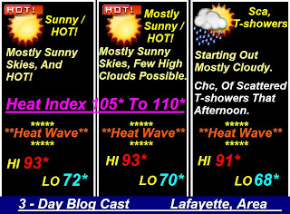
Now how about we take a quick look at your outlook???? Well, what we are going to talk about is temperatures and some scattered showers likely! What we are seeing is a strong low pressure system to our north over the Michigan area. This is what will bring not only the scattered showers but also the cooler temperatures much like what we seen yesterday as we only had a high in Lafayette, of around 82.2* degrees! Yes, this counter clockwise flow will bring down the cooler northern air keeping us in the 70s for the next few days! Yes, we will go from ABOVE average temperatures right down to BELOW average temperatures! (CRAZY) is the word! But in Indiana this is VERY believable! :) Take a look at this map I put together for you all below!You can see the low to our north that we are tracking this week. Now the thing with this rain chance is that (Chance) is the key word! Most of the models are showing a slight chance later on this evening or later into Wednesday. Not everyone will see rain however it is looking light and very scattered! So not looking like an all day continued rain! Just scattered / few and far between..... Otherwise today we will look partly cloudy for the most part! (Thank goodness) Cooler temperatures in the 70s today around 77* degrees possible. Tomorrow highs also in the 70s around 70* to 71* degrees possible! That is a good 15* degrees below our average for this time of year! Again I say CRAZY! :)
~~~~~~~~~~~~~~~~~~~~~~~
~~~~~~~~~~~~~~~~~~~~~~~
Now everyone I feel like I want to say a little something about this. Billy Mays I just found out Sunday night was found dead in his house. I have to say this shocked me a LOT! Billy Mays is a wonderful guy and an amazing pitch man. I watched his TV show "Pitch Men" all the time and you really start to feel as though you know him in a way! I always thought it would be great to meet him one day! He just has one of those happy go get them kind of attitude's and that is something good to have. With not only this but also Michel Jackson, Farrah Fawcett, and the WONDERFUL Ed McMahon, this is just WAY to many good people in one month! And some of them where WAY to YOUNG!!!! 50s???? Wow. This really got to me and really made me think about a lot! You really don't notice how much you take for granted until its gone! And I for one will NOT let that happen with my family!!!! "NO WAY NO HOW" Life is really to short. And if we think about it, Every animal but Man, knows that the thing about life is to (ENJOY IT) So go out and Enjoy life to its fullest! Love a lot more and hate a lot less because life is to short.

Have a wonderful day bloggers! I'M going to go relax and just spend some time with the family I love....................

Saturday, June 27, 2009

The Cooling Of The Cold Front!! Could It Bring Storms??

OK bloggers here is the latest on what we have to expect for the rest of this evening into tonight!

We are tracking a cold front that will push through the area later on tonight into tomorrow / Sunday! This will cool us off some however it is also firing up some storms in areas of IL, as we can already see on the national views of the Doppler Radar's. This is the line that will make a move on the WLFI viewing area later on tonight! (HOWEVER) The good news is the latest model runs are showing this line weakening as it moves into our more stable atmosphere. Currently our Lifted index is around +8.0 which is GREAT!! And my latest models are not showing anything severe for tonight at this time! The SPC also agrees with my forecast as they have taken us out of the severe risk area for tonight! Still we have the chance at some scattered thundershowers possible later on late tonight sometime closer / after 2:00am early Sunday morning. Rainfall is currently expected to be anywhere between a Tenth inch to a Quarter inch possible. We will see winds try to pick up a slight bit more as the night goes on into early Sunday however they are only looking to be between 20 and 25 mph with a few gusts to 28 mph possible.

Over all at this time I think we miss out on the worst! However thundershowers cannot be ruled out just yet! So everyone enjoy your weekend! I will be here tonight watching things (Only to be safe) However things look good at this time! ;)

Have a good one!

Watching The Weekend Weather! Thundershowers Sunday However Cooler Temperatures Make Up For It!!

Hey Bloggers! First off thank you all for the Happy 500 wishes! ;) This makes 501!! lol. Well, it is the weekend and we are loving it right???? Well, the good news is after today we will really start to notice some cooler weather move into the area! Yes, I think the heat wave may be over! Today we will look for highs around 89* degrees with mostly sunny skies. Lows look to be in the upper 60s around 68* degrees! However some more rain showers are going to be back in our forecast this weekend! Yes, We are looking for a line of showers to move into the area by early Sunday! We will look for rainfall between a quarter and a half inch possible. A few thundershowers cannot be ruled out at this time. And you all know I will keep you posted as needed! :]

For now I wanted to show you all this map below! This is showing our temperature outlook for the next 6 to 10 days! I think you will like this!
Take a look at that!! After being above average for the last week or so we will now fall slightly below average! At least this map thinks so! To let you know what our average is take a look. We usually average our highs around 85* degrees for this time of year! And lows around 62* to 63* degrees. I know yesterday evening I looked at Lafayette's temperature and it was at 80* degrees as the sun started to set. Those 80s felt sooooooo cool and nice I could not believe it! I think these 80s to come will be welcomed with open arms lol.

And now we will continue with the Last day of Lightning safety week!!!! Let's get started!
~~~~~~~~~~~~~~~~~~~~~~~~~~~~~~~~~~
~~~~~~~~~~~~~~~~~~~~~~~~~~~~~~~~~~
Lightning
On average, lightning kills more people per year than tornadoes. Strikes can occur many miles from the base of a thunderstorm, even without rain -- and even with the sun shining! Listening for approaching thunder is a good idea -- unless you are the target of the first flash. You can't dodge a lightning strike; and you will never see or hear the one which hits you.

~~~~~~~~~~~~~~~~~~~~
~~~~~~~~~~~~~~~~~~~~

Family at the Beach/Lake
You plan to go to the beach or lake later this morning with the kids. The weather forecast calls for a nice morning followed by a 30 percent chance of afternoon thunderstorms. You decide to head for the beach in your minivan. The beach is about 5 minutes from the parking lot. Once arriving at the beach, you notice the only nearby buildings are open sided picnic shelters with no obvious substantial wiring or plumbing. By early afternoon you notice the skies darkening and hear distant thunder. What should you and the kids do?


In this case, go to your car. Do NOT seek shelter under the beach picnic shelters. Wait 30 minutes until after the last rumble of thunder going back to the beach.
~~~~~~~~~~~~~~~~~~~~~~
~~~~~~~~~~~~~~~~~~~~~~

Camping
As you and your spouse are preparing dinner on the camp stove, you here rumbles of thunder in the distance. You look around and you see your tent is nearby, and a large open sided picnic shelter with no obvious substantial wiring or plumbing is just down the trail. Your vehicle is about ¼ of a mile away parked at the trail head. What should you and your family do?


Round up your family and go to your vehicle. The tent and picnic shelter are NOT a safe places. It is best to remain in your vehicle for 30 minutes after the last rumble of thunder is heard.
~~~~~~~~~~~~~~~~~~~~~~~
~~~~~~~~~~~~~~~~~~~~~~~

Motorcyclist/Bicyclist
People have been hit by lightning while riding motorcycles and bikes. Here are just a few examples:


Virginia Beach, VA: Motorcyclist killed while traveling on Route 58.
Colorado: a 16 year old boy killed while riding a bicycle.
Tennessee: a 47 year old man killed while leaning against his motorcycle.
Virginia: a man killed riding his motorcycle.

Protect Yourself when on a bicycle, motorcycle or dirt bike. Carry a portable Weather Radio or listen to commercial radio. If you see threatening skies in the distance and you are near a safe building, pull over and wait 30 minutes after the last rumble of thunder before resuming your ride.
~~~~~~~~~~~~~~~~~~~~~
~~~~~~~~~~~~~~~~~~~~~

So why are enclosed buildings with substantial wiring and plumbing safe to be in when lightning is occurring outside?
If lightning should directly strike a building with electricity or plumbing, the dangerous electrical current from the flash will typically travel through the wiring or plumbing, and then into the ground. This is why you should stay away from showers, sinks, hot tubs, and electronic equipment you are directly connected to such as corded telephones and computers.


Lightning can damage or destroy electronics so it's important to have a proper lightning protection system connected to your electronic equipment. The
American Meteorological Society has tips for protecting your electronics from lightning.
~~~~~~~~~~~~~~~~~~~~~~~~~~~~~~~~~~~~~~
~~~~~~~~~~~~~~~~~~~~~~~~~~~~~~~~~~~~~~
And last but not least I leave you all with these pictures sent in by Teri, that her daughter took while on her trip to Costa Rica, earlier this week. We may have to have her pop in on the Indiana Weather Blog to fill us in on her amazing trip! I mean just look at some of these pictures below. Amazing! Thanks to both Teri, and her daughter for these pictures!

Enjoy Bloggers!


After looking at these great views have a wonderful Weekend bloggers!!!!

Friday, June 26, 2009

Lightning Safety Is Something We ALL Need To Take NOTE OF!!

This Is My *****500th***** BLOG POST!!!!
Yes, that's right this is my 500th blog post to you all..... We are half way to a Thousand!!!! And we will get there in time! ;) I will tell you 500 post's have gone by FAST! lol. And I thank you all for making this a great friendly blog to come and get and give info! Your reports are amazing and really do help! That is what this blog is ALL ABOUT! Some Meteorologist think that they have to do everything on there own! However you bloggers and weather watchers are there Eye's and Ear's!!!! Without you all the forecast would be even more impossible then it is now! SO KEEP IT UP!!!! :)

Now let's get back to the weather! That is what you all came here for right?? ;]You can see above the developing cells that moved through the area last night! You see that cell just to the northeast of Lafayette. This was the cell that was just packed full of Lightning as it moved across the area. This cell went on through the Frankfort area as it continued to weekend which was great news! Nothing was severe with this cell however the lightning was very frequent and dangerous! (The NWS will not issue a severe thunderstorm for lightning) ((WHICH THEY SHOULD)) Would you believe there have been at least 15 people killed by lightning in the US to this Date Already!!!! And one was a ten year old boy in Indianapolis!!!! I really hope everyone remembered there Lightning safety tips last night!!!! This is the reason the NWS is doing the Lightning safety week. And this is why we will continue with it today!

Here is a link I think you all should really check out!!!!


Here is something below that EVERYONE should know!!!!

What do I do if someone has been struck by lightning?
If a person is struck by lightning, call 911 and get medical care immediately. Cardiac arrest and irregularities, burns, and nerve damage are common in cases where people are struck by lightning. However, with proper treatment, including CPR if necessary, most victims survive a lightning strike, although they may be left with serious and lasting effects. You are in no danger when helping a lightning victim, and you may safely do so immediately. The charge will not affect you.

~~~~~~~~~~~~~~~~~~~~~~~~~~~~~~~~~~

Here are some indoor safety tips I think will come in handy!!!! As last night we in the Lafayette area and other areas seen very frequent lightning. Even though your inside you still have a risk!! Take a look at these tips below.

Stay Safe While Inside
Phone use is the leading cause of indoor lightning injuries in the United States. Lightning can travel long distances in both phone and electrical wires, particularly in rural areas. Stay away from windows and doors as these can provide the path for a direct strike to enter a home. Do not lie on the concrete floor of a garage as it likely contains a wire mesh. In general, basements are a safe place to go during thunderstorms. However, there are some things to keep in mind. Avoid contact with concrete walls which may contain metal reinforcing bars. Avoid washers and dryers since they not only have contacts with the plumbing and electrical systems, but also contain an electrical path to the outside through the dryer vent.

Remember Your Pets
You may want to consider the safety of your family pets during thunderstorms. Dog houses are not lightning-safe. Dogs that are chained to trees or chained to wire runners can easily fall victim to a lightning strike.

Here is a look at all the Main lightning safety tips for inside the home above! Follow these tips and STAY SAFE!!!! We have one more day of lightning safety to go so we will talk a little more about this on the Indiana Weather Blog later on tonight! Until then here is your Quick Cast Blog Cast I have put together for you all below! Have a great Sunny HOT day!!!! ;]

Quick Cast Blog Cast..............................

Today we will look for some Partly cloudy to mostly sunny skies with this hot heat wave still keeping our highs in the low 90s around 91* degrees. Lows still only falling into the low 70s around 70* degrees. Winds will be light not doing much to cool us off between 5 and 10 mph.

Saturday we will see some more Sunny skies to start things with skies turning more Partly cloudy as we head into that evening / night. Later on late that night into Sunday Early we will see a cold front push through the area bringing some rain and possible thunderstorms along with it! rainfall looks between a quarter and a half inch possible. Highs will be in the low 90s and lows in the upper 60s. Winds will be light between 3 and 5 mph.

Sunday we may have some early left over light showers however overall we will become partly cloudy to mostly sunny with highs slightly cooler as that front pushes through the area dropping our highs to the middle 80s around 86* degrees possible. Lows will fall to the middle 60s! Finally we will get a break from all this Crazy hot weather!

Thursday, June 25, 2009

Watching The Cells.

What we are seeing is these pop up cells across the area that are packed with dangerous lightning and some small hail is also still possible in areas! This cell is heading into Mulberry, Cambria, Cities of Frankfort, and also Manson. Currently there is nothing severe with this cell however Lightning is ALWAYS A SEVERE THREAT!! I think lightning is going to be a main threat with this cell.... Teri just reported some very frequent cloud to ground lightning on the south side of Lafayette looking Northeast!

I will pop back in as needed.....

WIll Anything Develop?!?! (Watching To Be Safe)

Severe Thunderstorm Watch

SEVERE THUNDERSTORM WATCH 512 IS IN EFFECT UNTIL 900 PM CDT
FOR THE FOLLOWING LOCATIONS

. INDIANA COUNTIES INCLUDED ARE
BENTON JASPER LAKE
NEWTON

~~~~~~~~~~~~~~~~~~~~~~~~~~~~~~~~~~
~~~~~~~~~~~~~~~~~~~~~~~~~~~~~~~~~~
Well you can see that some of our northern counties have been put into this Severe thunderstorm watch until 9:00pm CDT tonight! I just wanted to pop in real quick and just let you all know what we are looking for / to develop tonight!

We are tracking the possibility of some scattered thunderstorms to develop later on tonight across parts of the area! Not everyone will see storms. However the whole state is still in that slight risk for severe! We have around a 20% to 40% chance at storms tonight. Anything that would develop would be Scattered across the state! (If it develops!) I will be here watching things through out the night! And if anything changes I will let you know! Currenlty I thing we will keep our tornado threat at a LOW threat at only 2% or less, Hail at a 5% to 15% chance and Wind the same at only a low 5% to 15% chance....

Now back to enjoying your evening! Still be careful with heat index currently at 95* degrees!!!! (Keep Cool) I will check back! ;]

Yesterday Was The Hottest Day So Far This Year!! And Also Had Some Of The Most Beautiful Pictures!!

Well, Mary Anne, shows us above how things started looking yesterday evening with all those towering cumulus clouds and or storm clouds to our south west..... I also got to see many of these clouds around the area as Me my Sister and my Grandma went out for a nice drive through the country to get some film for my new music video I'M working on! I will have to post a link to it when it is all finished! Now back the the towering clouds lol.... I was out taking some film and was hearing some light thunder rumbles to my northwest moving southeast. I could tell nothing was severe however there where many clouds just like this one Mary Anne, shows us above! Over all the sky was just beautiful in more ways then one! Below you can see how the sun was hitting these towering clouds that evening.
First off a big thank you to Mary Anne, and Teri, For sending in these Wonderful Pictures!! Teri, sends in this picture above as the sun was setting over the Lafayette, area last night! I love that Fire red color hitting the clouds! And it goes along with the heat of the day as well! Fire red color with Fire hot temperatures! We had one of the hottest days of the year so far with Lafayette's, high temperature of 96.6*F degrees!!!! We even hit a heat index temperature of 106*F degrees!!!! It was no wonder we had a heat advisory out over much of the WLFI viewing area! You figure our average high temperature for this time of year is around 85*F degrees and our record high set back in 1988 of 97*F degrees, We was mighty close!!!! Only 0.4* degrees shy of the record!!!! So close yet so far!!!! We ALMOST smashed it! ;]Now back to the sky yesterday! You can see this picture above that yours truly took yesterday evening of the beautiful Cirrocummulua clouds also known as Mackerel sky!! Mackerel Sky is there nickname because if you really look at them closely they look like they are rippled or like fish scales.... This is how things looked just a few hours after those towering clouds passed.... Mackerel sky is known as an omen of good weather! and that is just what we seen last night! However today will be another story!!!! Why, you ask?? Well, read on! ;)


Today we are going to be tracking some more scattered thunderstorms across the area! Yes, today late morning / this afternoon we will be looking for some more widespread Thunderstorms over the WLFI viewing area. These storms are coming from our northwest in the Iowa, areas! We are currently looking at CAPE anywhere between 2,500J/kg to 3,500J/kg along with Lifted Index around -4 to -8 possible. In other words we will become pretty unstable today. Enough to fire up a few more storms anyhow! The National Weather Service does have us in that Slight risk for severe area today which is another reason why we will not rule out a possible stray strong storm or two just yet! We will be looking for rainfall between a quarter inch and a half inch possible with higher amounts expected in storms!

You all already know I will be popping in through out the day today with more updates! Also in storm updates (If Needed!)

And last but not least I did get a few pictures yesterday while I was filming and I thought you all would enjoy this picture below! This was taken over the Wea, creek. Have a wonderful day Bloggers! I will check back later on today as needed.......... See Ya Then....................

Wednesday, June 24, 2009

The Forecast Is On Fire!

Well, Bloggers it was a HOT one yesterday and we have more Hot weather to get through today! Yes, Highs hit the low 90s yesterday and Today we will look for highs in the Low 90s again around 93* degrees! Heat index again in the 100s!!!! Remember those Heat Advisories we had out for parts of the WLFI viewing area yesterday???? Well, today they have been extended over much more of the viewing area! Take a look below!!
~~~~~~~~~~~~~~~~~~~~~~~~~~~~~~~~~~~~
~~~~~~~~~~~~~~~~~~~~~~~~~~~~~~~~~~~~
URGENT - WEATHER MESSAGE

HEAT ADVISORY

CARROLL-WARREN-TIPPECANOE-FOUNTAIN-MONTGOMERY-VERMILLION-
INCLUDING THE CITIES OF...LAFAYETTE...CRAWFORDSVILLE

...HEAT ADVISORY REMAINS IN EFFECT FROM NOON TO 7 PM EDT
WEDNESDAY...
~~~~~~~~~~~~~~~~~~~~~~~~~~~~~~~~~~~~
~~~~~~~~~~~~~~~~~~~~~~~~~~~~~~~~~~~~

This also includes our northern counties of Benton, Newton, and Jasper, from now until 7:pm EDT Wednesday!

Things we all should do today is try to stay in the Air Conditioned rooms, Drink lots of water, And as always (Check up with your family and neighbors) Make sure they know the dangers of this heat and keep them all safe as well!!

We will be keeping it dry again today with lots of Sunny skies through out the day until later on tonight which is when we will start to see some more clouds slowly move into the area! Early morning of Thursday is our next chance at some more rainfall / Thundershowers possible. Currently I'M not looking for anything severe however rainfall looks between a Quarter inch to a Half inch possible with locally higher amounts in thunderstorms possible. Otherwise we are looking for Below average Precipitation for the next 6 to 1o days! Take a look at this map below from the CPC..... Could we be looking for a small dry spell!?!?!!!!! :] Hummmmmm.....Not only will we be looking for below average precipitation! But also Above average Temperatures for the next 6 to 10 days! Yes, our average high temperature for this time of year is around 84* degrees! And we are running in the low 90s through out much of this week!!!! Which is around 6 to 7 degrees above average!! I say again it is a good thing we have the pool going! LOL :} Take a look below!Just look at all that beautiful Orange color over our area!! It sure is funny how in the winter we are all ready for Summer and in the Summer / in all this HEAT we are ready for more cooler weather! I for one can't wait for Winter again! But as you all know I'M and BIT snow lover and enjoy every minute of it! :] But this is just the start of Summer and we have much time to go before Winter returns!

And now to take our minds off of this heat (If that is even possible!) :] Let's continue our Lightning Safety week with more helpful tips below! Have a good one Bloggers!!
(AND STAY COOL!!)

What if I am outside and no shelter or vehicle is available?
If no safe shelter is available, you can only reduce your risk of being struck by avoiding a common mistake. Do NOT seek shelter under tall, isolated trees or partially enclosed structures. This will keep you dry, but will enhance your vulnerability to lightning. Ensure that you are familiar with the latest weather forecast for your area. If thunderstorms are possible or expected, curtail your outdoor activities during that time, or ensure that you have constant access to a sturdy, fully enclosed shelter, such as a home or business.

Tuesday, June 23, 2009

The Forecast Say's We Don't Need The Grill's To Fire Thing's Up Today!!!!!

Well, it is going to be so hot today we may not need the grill to fire things up!!!! Yes, you can see above the cookout from Father's Day! It was a really nice time and I think our Dad had a good time! Mainly because this was the first time in a few years that he did not have to do the cooking on Father's Day lol. After a nice lunch we all headed into the living room to catch the Indy Car race! Which my man Tony Kanaan, did not finish.... :( However he will get them next time!! Also you can see below not only did the people have a great time but also the Doggies!!!!
You can see our friend's Basset Hound Kenzy, was having a GREAT time rolling around in the grass and also had some fun chasing my dog Dobby, who is a Rat Terrier, around her big yard. They all love going out there where they have much room to run and go wild lol.... Kinzy pretty much stayed by me only because I was doing all the cooking! She was hoping I would drop something. (Right Into Her Mouth) LOL :)

It was a good time and now we have some HOT weather to track!!!! Yes, we are tracking a Heat Wave over our area this week. And we will see high shoot up into the low 90s!!!! We will be seeing Heat Index in the 100s over the next few days starting today! I think we will look for mostly sunny skies today with that high in the low to middle 90s and lows only falling into the low 70s! (It is a good thing we got our pool going) LOL. Here is a quick look at your 3 - Day outlook map below.....
You see the High temperatures above! And to make things even hotter! The winds will not do much to cool you off this week! Yes, Today we will look for really light winds between 5 and 8 mph and tomorrow much of the same with winds between 3 and 5 mph..... Yes, it is going to be a AC, week and keep cool by the pool..... If the people down in Florida, can do it and that includes our very own Mike Prangley, who as you ALL know lived many years here in the Midwest. Then we can to!! ;) Just hang in there. And if your out doing lawn work it would be best to wait until later on this evening around 7:00pm or so. This way we have time to cool off a bit! Just drink lots of water and try to stay cool..........
Now as you can tell by the picture above that it is Lightning Safety week!!!! And anyone who lives in Indiana, knows Lightning is a pretty common thing! We have storms just about every week and lightning is ALWAYS one of our main threat's! So today we will talk a little about Lightning safety as well as through out this week, This way we all will be ready for any more storms to come! It is just the beginning of Summer and we have many storms to get through! So lets take a look below.....

There are an estimated 25 million cloud-to-ground lightning strikes per year in the United States, each one capable of seriously injuring or killing anyone unlucky enough to be struck. Aside from the average of 62 deaths, an average of 300 lightning injuries are reported each year, although this number is likely under reported because many people do not seek help, and doctors may not record a patient as suffering a lightning injury. Unfortunately, lightning strike survivors often suffer a variety of long-term physical and mental effects, including mood changes, memory loss, sleep disorders, pain, numbness, stiffness, dizziness, irritability, fatigue, muscle spasms, and depression.

How can I keep myself and my family safe from lightning?
The short answer is: easily. Always keep in mind that if you can hear thunder, you are close enough to be struck by lightning. Seek shelter immediately in a sturdy building or, if a building is not available, a hard-topped vehicle with the windows rolled up. When indoors, refrain from using corded appliances or other equipment or facilities that put you in contact with electrical systems or plumbing. Stay inside until at least 30 minutes after the last lightning strike. This is very important, since lightning can and occasionally does strike well away from the thunderstorm itself. ~~~~~~~~~~~~~~~~~~~~~~~~~~~~~~~~~~ ~~~~~~~~~~~~~~~~~~~~~~~~~~~~~~~~~~

Have a wonderful day Bloggers! And keep safe from the Heat!!

And My helpful hint of the day!!! You can help make the world a better place by One Act of Random Kindness at a time.......... Make It a Good One Bloggers! ;o)

Monday, June 22, 2009

Lightning Safety Awareness Week Is Here!! Along With Some Hot Days Ahead?!?! We Will Brake All This Down Through Out This Week Along With Much More!

~~~~~~~~~~~~~~~~~~~~~~~~~~~~~~~~~~~
~~~~~~~~~~~~~~~~~~~~~~~~~~~~~~~~~~~
Heat Advisory
URGENT - WEATHER MESSAGE
~~~~~~~~~~~~~~~~~~~~~~~~~~~~~~~~~~~

~~~~~~~~~~~~~~~~~~~~~~~~~~~~~~~~~~~
...HEAT ADVISORY IN EFFECT FROM TUESDAY AFTERNOON THROUGH WEDNESDAY...

NEWTON-JASPER-BENTON-WARREN

...HEAT ADVISORY IN EFFECT FROM NOON CDT /1 PM EDT/ TUESDAY TO
7 PM CDT /8 PM EDT/ WEDNESDAY...


THE NATIONAL WEATHER SERVICE IN CHICAGO HAS ISSUED A HEAT
ADVISORY...WHICH IS IN EFFECT FROM NOON CDT /1 PM EDT/ TUESDAY TO
7 PM CDT /8 PM EDT/ WEDNESDAY.
~~~~~~~~~~~~~~~~~~~~~~~~~~~~~~~~~~~~
~~~~~~~~~~~~~~~~~~~~~~~~~~~~~~~~~~~~


Hey Bloggers! Did everyone have a wonderful Father's Day Weekend???? Our cookout turned out great and the best news of all was I got all my cooking done before that light rain moved in we talked about yesterday! So the hotdog's stayed dry! lol. Lafayette only picked up right around that Tenth inch mark we was calling for! And remember we said we would have the better chance at more widespread showers on Monday!! Well, we did wake up to some of those scattered thundershowers this morning.

But first!!

I just wanted to pop in real quick today with the weather outlook and just some of what we will be talking about through out the week.....

First off we did see those showers / thundershowers move across the area early this morning dropping rainfall on Lafayette, around .60" inches. However through out most of the day today I look for us to see these mostly to partly cloudy skies however we will still keep around a 40% chance at some more scattered thundershowers later on this evening. Now not everyone will see these scattered showers. If you don't see them then I look to keep you all mostly to partly cloudy! However when the weather models show us a slight chance at rain then we have to put in that slight chance! ;) Another thing we will talk about this week is a heat wave moving into the WLFI viewing area! Yes, today we will see highs in the upper 80s around 89* degrees possible. With temperatures in the low 90s tomorrow and possibly Wednesday! Tomorrow will be a nice hot one with highs in the low 90s and lots of partly cloudy to mostly sunny skies through out the day!

And last but not least it is, Lightning Safety Awareness Week, June 21-27, 2009 "When thunder roars, go indoors!"
The week of June 21-27, 2009 is Lightning Safety Awareness Week nationwide. Lightning is an underrated killer, responsible for an average of 62 deaths per year across the country. Of all storm-related hazards, only flooding claims more lives per year on average. Yet, because lightning rarely causes mass destruction of property or mass casualty events, the dangers associated with it are underappreciated.


We will be talking about this through out this week as well. On how to stay safe when that Thunder Roars!!!! Stay safe Bloggers! Have a wonderful day and I will check back later on tonight with all this and more! Be sure to check back!

See Ya Then....................

Sunday, June 21, 2009

Fathers Day Weather Outlook.....

Hey Bloggers..... Happy Fathers Day!! I will be heading out to my Aunts as soon as I finish this blog post today! Going to have a small get together for our Fathers Day..

But first I wanted to pop in with the Fathers Day outlook. So lets get to it!

Today we do have around a 40% chance at some light rain showers to move into the area later on this afternoon however we are only looking for rainfall around a Tenth inch or so. As we head into Monday morning / Tuesday that is when we will have the better chance at some more widespread showers. Until then today we can OK for Partly to Mostly cloudy skies. With more clouds on the increase this afternoon. Then that slight 40% chance at some scattered showers possible.

Well, I had better get going the Family is whiting!!!! Talk with you all here on the Indiana Weather Blog Later!!!!

Have a Good One!

Saturday, June 20, 2009

A Look At Last Night's Storms..... And Happy Fathers day Weekend!!

Rainfall Amounts From Around The Area In Last Night's Storms.

Williamsport,_______________1.40"
Attica,____________________1.39"
Kentland,__________________1,12"
Lafayette,_________________ .70"
Rensselaer,________________ .60"
Logansport,________________ .53"
~~~~~~~~~~~~~~~~~~~~~~~~~~~~~~~~~~
~~~~~~~~~~~~~~~~~~~~~~~~~~~~~~~~~~

You can see the line of storms that went through our area last night bringing the severe thunderstorm warnings along with it! Yes, you can see that line of Red boxes kinda taking up the WLFI viewing area. Also if you look closely you can see the more north you go the better things looked while the more south you went the worse things got! And this really was the whole story last night. And you can really see why below..... Take a look at some of these severe storm reports to the SPC below.....

~~~~~~~~~~~~~~~~~~~~~~~~~~~~
~~~~~~~~~~~~~~~~~~~~~~~~~~~~

*****HAIL REPORTS*****

Size, 88 1 S VEEDERSBURG FOUNTAIN IN
NICKEL SIZE HAIL AND FUNNEL CLOUD (IND)

~~~~~~~~~~~~~~~~~~~~~~~~~~~~
~~~~~~~~~~~~~~~~~~~~~~~~~~~~

*****WIND REPORTS*****

Speed, 60 TERRE HAUTE VIGO IN
AT SKY KING AIRPORT NORTH SIDE OF TERRE HAUTE. (IND)

Speed, UNK DANA VERMILLION IN
TREE LIMBS DOWN. (IND)

Speed, 65 LADOGA MONTGOMERY IN
~~~~~~~~~~~~~~~~~~~~~~~~~~~~
~~~~~~~~~~~~~~~~~~~~~~~~~~~~

*****TORNADO REPORT*****

3 SE FAIRMOUNT VERMILION IL
BRIEF TORNADO TOUCHDOWN, LASTING 30 SECONDS. (ILX)
~~~~~~~~~~~~~~~~~~~~~~~~~~~~
~~~~~~~~~~~~~~~~~~~~~~~~~~~~
You can see the Tornado report above. This was the cell that caused the NWS to put out the first Tornado warning for Fountain, county last night. You can see that there was a tornado that did touch down. It was not for long however I'M sure everyone in that area was very glad it was only around 30 seconds..... This is the cell that moved east into the Fountain, county area. No there was not any tornadoes reported in the WLFI viewing area thank goodness. However there was a funnel cloud reported with that cell. Along with the Hail report you see above of hail .88" inches in size! (What A Night)Now above is a picture of some beautiful Altocumulus clouds. This picture I took here in the Lafayette, area after the storms had passed. These clouds are usually White to Gray in color. And are often Rippled or appear in waves. They are considered fair weather clouds. And they often follow storms. Much like they did last night as seen above! They really are beautiful and I'M glad I got this picture..... So now that all the storms are passed and it is the weekend what do we have in store???? Well, Lets read on and find out!
You can see in the Map I put together above that we are looking much better today with some Partly cloudy skies and highs in the upper 80s once again around 89* degrees. Lows will also still be rather mild around 70* degrees. Sunday also looking good with mostly sunny skies and highs around 88* degrees with lows in the middle 60s around 64* degrees. This will give us a much needed break after all this CRAZY Indiana weather we have all been seeing so much of lately.....
So everyone! Go have a wonderful weekend. And remember it is not just any weekend! That's right it is Fathers Day weekend! HAPPY FATHERS DAY! All be sure to do something nice for your Fathers..... It will be GREAT grilling weather.... ("Hint" "Hint") lol :)
Have a good weekend Bloggers! I really need some rest..... "YAWN" ;) I'll see you all again here on the Indiana Weather Blog Monday. Then we will talk about Lightning Safety Awareness Week. Which if from June 21-27. When thunder roars, go indoors!"
See You All Then.....

Friday, June 19, 2009

Update At 10:15PM And Looking Better!! Now Time To Baby Sit..... ;)

Well, the worse is over tonight! Yes, we MADE IT! There is still that small line to our west in IL, however that is not expected to become severe or anything like what we seen tonight. Still some scattered rain / thundershowers are possible off and on through the night.

Really it was our southern counties that took the main severe storms this evening. Anywhere from Tippecanoe, / Warren, counties south was hit hard..... As for our northern counties things kinda let up as the cells started to show signs of weakening as they moved across the area.

We did have many Hail reports over the area tonight as was expected. Wind reports as well however they where mostly south. We still seen our gusts over 30 mph like we talked about earlier this afternoon.....

I will still be right here at my Weather Desk watching the radars or more like Baby sitting them.... LOL until this line in IL, fully moves out! Also I will be working on your blog post for tonight. We will talk about some of the crazy weather seen we tonight. I know the northern counties did not see to much however the southern counties got some goodies..... Also a look at your weekend outlook. And maybe a look ahead at the next three months..... Can some of us in the WLFI viewing area finally get to open up that pool???? Be sure to check back to fine out!
~~~~~~~~~~~~~~~~~~~~~~~~~~~~~~~~~~~~~~~
~~~~~~~~~~~~~~~~~~~~~~~~~~~~~~~~~~~~~~~

*****9:09PM Update*****

These cells are really showing signs of weakening over our northern counties! This is great news..... Still we are keeping a close watch to the areas of Fountain county. And South Tippecanoe, and Montgomery, county....

Our main threats in Lafayette look to be Dangerous lightning..... Heavy Downpours..... And gusty winds.....

There is still that Tornado warning in Fountain county..... Good news is I'M not picking up much if any rotation at this time! The only thing is we have another line on the back side that we will continue to watch just to be safe! I will be back with more on that in just a short few!

Here is another warning just put into effect for .....

* TORNADO WARNING FOR... SOUTHERN FOUNTAIN COUNTY IN WEST CENTRAL INDIANA... SOUTHWESTERN MONTGOMERY COUNTY IN WEST CENTRAL INDIANA... NORTHERN PARKE COUNTY IN WEST CENTRAL INDIANA... NORTHWESTERN PUTNAM COUNTY IN WEST CENTRAL INDIANA...
* UNTIL 930 PM EDT

Watching The Warnings...

I have Doppler Showing me the TVS for fountain county. It looks as though this would be just north of Mellott, really in between Newtown, and Mellott, I have reports of really High GUSTY WINDS in the Mellott area with Heavy downpours Frequent Lightning / Thunder.....

~~~~~~~~~~~~~~~~~~~~~~~~~~~~~~~~
IN ADDITION TO THE POSSIBLE TORNADO...THIS STORM IS CAPABLE OF PRODUCING QUARTER SIZE HAIL AND DESTRUCTIVE STRAIGHT LINE WINDS.

* TORNADO WARNING FOR... CENTRAL FOUNTAIN COUNTY IN WEST CENTRAL INDIANA...
* UNTIL 915 PM EDT


I'M picking up some slight rotation with this cell over the Fountain county area! (I will keep you posted)


~~~~~~~~~~~~~~~~~~
~~~~~~~~~~~~~~~~~~

The severe thunderstorm warning for Benton, Newton, And Jasper, is not canceled!

We are still watching these cells to our south west. And for the counties from Warren, Tippecanoe, South.....
~~~~~~~~~~~~~~~~~~
~~~~~~~~~~~~~~~~~~

Update As Of 8:35PM EDT

Lafayette, is looking at these cells to our south and west. I'M looking for us to be put into a severe thunderstorm warning here within the next few minutes or so. Good news is I'M currently not picking up any rotation in our area however with a line of cells like this it is still possible! (Keep your guard up) We are looking for winds possible near 60mph in storms! They can be just as bad! I will keep you posted!

I will check back..........

Update At :26PM EDT

We have Lightning and Thunder here in Lafayette as I type! The good news is this system does not look at strong as it did earlier this evening. Still however it is a strong system and needs to be watched! I do think most of these cells will be pushing out by sometime closer to 11:00pm tonight.We also have a new severe thunderstorm warning put into effect for Fountain county, Warren county,. Until 9:15PM EDT.....

DOPPLER RADAR INDICATED A LINE OF SEVERE THUNDERSTORMS CAPABLE OF PRODUCING QUARTER SIZE HAIL...AND DAMAGING WINDS IN EXCESS OF 60 MPH.

ALSO BELOW!!!!

SEVERE THUNDERSTORM WARNING FOR... SOUTHERN WHITE COUNTY IN NORTHWEST INDIANA .... Expect Wind over 60mph.....

* UNTIL 930 PM EDT


~~~~~~~~~~~~~~~~~~~~~~~~~~~~~~~~
Severe Thunderstorms Warning in effect for Benton, Newton Jasper, counties until 8:30pm CDT and 930 EDT..... THESE STORMS ARE CAPABLE OF PRODUCING DESTRUCTIVE WINDS IN EXCESS OF 70 MPH.
~~~~~~~~~~~~~~~~~~~~~~~~~~~~~~~~~~~

The Line Is Near!

We still have some slight rotation showing up on Doppler Radar at this time In Fountain county. This cell is showing some signs of weakening however it is still a very dangerous system! Still stay tuned and safe!!

Well, is everyone ready???? We have a line of storms moving in on us fast! We have a whole lot of warnings about to over take the WLFI viewing area. Yes, they will become more wide spread across the area here real soon. Rainfall is already entering our northern counties like Benton, and Newton, counties. Hang in there fellow Bloggers! And keep the reports coming!!!! The team will get through it!!

I will be checking in frequently!!!

~~~~~~~~~~~~~~~~~~~
~~~~~~~~~~~~~~~~~~~

PERRYSVILLE, in Fountain,Be ready as the main batch of this rotating cell is just about over your area. This cell also has hail 1.25" inches in size! Also be ready for DESTRUCTIVE STRAIGHT LINE WINDS. and dangerous cloud to ground lightning.....
~~~~~~~~~~~~~~~~~
~~~~~~~~~~~~~~~~~


Severe thunderstorm warning for Newton and Benton counties until 7:15PM CDT.....THESE STORMS ARE CAPABLE OF PRODUCING QUARTER SIZE HAIL...AND DAMAGING WINDS IN EXCESS OF 60 MPH.

SEVERE THUNDERSTORMS LOCATED ALONG A LINE EXTENDING FROM WATERMAN TO 8 MILES WEST OF DWIGHT TO 8 MILES SOUTH OF GIBSON CITY...AND MOVING EAST AT 55 MPH.

Watching Tornadoes!

If you are in the Fountain County area be ready to get to your safe spot.... We are watching rotation closely with this cell..... Area in the Path are....... GESSIE AROUND 725 PM EDT... FOSTER AROUND 730 PM EDT... PERRYSVILLE AROUND 735 PM EDT... COVINGTON AROUND 740 PM EDT...
~~~~~~~~~~~~~~~~~~~~~~~
~~~~~~~~~~~~~~~~~~~~~~~


Tornado Warning out for Fountain county * AT 708 PM EDT...TRAINED WEATHER SPOTTERS REPORTED A FUNNEL CLOUD 8 MILES WEST OF GESSIE...OR 6 MILES SOUTH OF DANVILLE...MOVING EAST AT 25 MPH.

* THE TORNADO WILL BE NEAR... GESSIE AROUND 725 PM EDT... FOSTER AROUND 730 PM EDT... PERRYSVILLE AROUND 735 PM EDT... COVINGTON AROUND 740 PM EDT...

I'M watching this Rotation closely..... Also I'M watching these towering clouds to over 60,000FT. This is a strong cell and needs to be watched closely!! I will keep you posted!
----------------------------------

----------------------------------

Tornado Watch.....

This is the Watch that was put into Effect earlier today until 7:00pm tonight. This watch has been extended as expected until 3:00AM EDT for the Following counties below.

TORNADO WATCH 483 IS IN EFFECT UNTIL 300 AM EDT FOR THE
FOLLOWING LOCATIONS

. INDIANA COUNTIES INCLUDED ARE
ADAMS
ALLEN
BLACKFORD
BOONE
CARROLL
CASS
CLAY
CLINTON
DECATUR
DELAWARE
DE KALB
ELKHART
FAYETTE
FOUNTAIN
FULTON
GRANT
HAMILTON
HANCOCK
HENDRICKS
HENRY
HOWARD
HUNTINGTON
JAY
JOHNSON
KOSCIUSKO
LAGRANGE
LA PORTE
MADISON
MARION
MARSHALL
MIAMI
MONTGOMERY
MORGAN
NOBLE
OWEN
PARKE
PULASKI
PUTNAM
RANDOLPH
RUSH
SHELBY
ST. JOSEPH
STARKE
STEUBEN
TIPPECANOE
TIPTON
UNION
VERMILLION
VIGO
WABASH
WARREN
WAYNE
WELLS
WHITE
WHITLEY

Watching Things Closely.....

Severe thunderstorm Warning for Eastern Benton Counties. This is one of those cells we was just talking about. This small cell is moving ENE at around 20 mph. This cell is capable of producing Pea sized hail and gusty winds near 60 mph. This warning is in effect until 4:45pm EDT.....

Severe Thunderstorms Watch..... Is in effect until 10:00pm CDT... For the following Counties below.....

Benton, Newton, And Jasper, counties.
--------------------------------
--------------------------------
You can see the NWS has put a Severe thunderstorm watch into effect until 10:00pm tonight for some of our northern counties. We are currently watching some scattered thunderstorms that have fired up to our west in parts of IL. These storms are moving ENE at around 21 to 25 Kts, or around 23 to 29 mph. Currently they are not severe however with how unstable and warm we are currently they could become! With temperatures around 90.5* degrees and (LI) around -6.5 we have around a 40% to 60% chance at these scattered cells. This is just some storms firing up ahead of the main system later on tonight. Kinda like a little taste of whats to come..... Still I'M watching the main storms to start closer to 6:00pm or 7:00pm this evening ((or at least be close!!)). And then still with more wide spread storms as we head into this evening after 7:00pm into early A.M of Saturday..


Still with these storms tonight I'M going to keep our main threats being.....

Large Hail (Possible.)

High gusty winds. (Still outside storms gusting between 30 - 35 mph. Higher In Storms.)

Dangerous Frequent Lightning. (Cloud To Ground)

Heavy Rainfall. (Between A Half Inch And One Inch Possible) Expect Locally Higher Amounts In Storms.

And An Isolated Tornado Still Cannot Be Ruled Out. (Tornado Threat Is At A 10% Chance At This Time. What we have to continue to watch is the "Helicity" along with our CAPE. This is the wind shear that supports the spin needed to form tornadoes..... Usually you need Helicity to be around 300 to 400 to support severe thunderstorms. This is what we are currently look at! This is why a (Isolated) Tornado cannot be ruled out just yet. You need to use Healicity along with CAPE to give an (idea) where tornadoes would be most likely to form (IF) they where to form. So with High CAPE over our area anywhere between 3,500J/kg to 4,000J/kg and "Helicity" between 300 and 400, We shall keep our guard up! (Just to be Safe)
~~~~~~~~~~~~~~~~~~~~~~~~~~~~~~~~~~~~~~~~~~

I will continue to check back as needed....................

****Noon Update**** (Here We Go AGAIN!!)

TORNADO WATCH 478 IS IN EFFECT UNTIL 700 PM EDT FOR THE
FOLLOWING LOCATIONS


. INDIANA COUNTIES INCLUDED ARE
ADAMS

ALLEN
BENTON
BLACKFORD

BOONE
CARROLL
CASS

CLINTON
DELAWARE
DE KALB

ELKHART
FOUNTAIN
FULTON

GRANT
HAMILTON
HANCOCK

HENDRICKS
HENRY
HOWARD

HUNTINGTON
JASPER
JAY

KOSCIUSKO
LAGRANGE
LAKE

LA PORTE
MADISON
MARION

MARSHALL
MIAMI
MONTGOMERY

NEWTON
NOBLE
PORTER

PULASKI
RANDOLPH
ST. JOSEPH

STARKE
STEUBEN
TIPPECANOE

TIPTON
WABASH
WARREN

WELLS
WHITE
WHITLEY

-----------------------------
-----------------------------

Flash Flood Watch ..... Is in effect through late tonight for.

Benton,

Newton,

Jasper, Counties.

Yes, we do have that Tornado watch in effect for the WLFI viewing area until 7:00pm EDT for the counties you see above.....

This is in effect because we are going to be looking at EHI, of 3.75 to a possible 5.0. Which shows that there will be the rotation needed to support the making of tornadoes. Also we are still looking for our Lifted Index to fall between -6 and -8 with a CAPE value around 35,00J/kg to a possible 4,000J/kg. Which also would support some large hail and Dangerous Frequent Lightning.


SO all together we are looking for Scattered Thunderstorms / Few Severe / Isolated Tornado possible. Rainfall would be between a Half Inch And Three Quarters Of An Inch Possible with locally higher amounts in thunderstorms.

Main Threats Will Be.....

Dangerous Cloud To Ground Lightning. (Frequent)

Large Hail Possible.

Heavy Rainfall.

High Gusty Winds. (Gusts To 30 - 35 Mph Outside Of Thunderstorms Later On Late Tonight.)

An Isolated Tornado Cannot Be Ruled Out Just Yet.
----------------------------------
----------------------------------

I will check back off and on through out the day..... As needed.....

(Stay Tuned)

Freaky Friday In More Ways Then One!!

****SEVERE THUNDERSTORM WATCH****
IS IN EFFECT UNTIL 700 AM CDT

FOR THE FOLLOWING LOCATIONS

. INDIANA COUNTIES INCLUDED ARE
DE KALB, ELKHART, FULTON,
JASPER, KOSCIUSKO, LAGRANGE,
LAKE, LA PORTE, MARSHALL,
NEWTON, NOBLE, PORTER,
PULASKI, ST. JOSEPH, STARKE,
STEUBEN,

----------------------------------------------------
----------------------------------------------------

That's Right It Is For Sure A Freaky Friday!!!! OK, Some of us may be waking up to some scattered thundershowers this early morning. However the real heavy stuff is still to come later on this evening / tonight into early Saturday and that is what we are here to talk about. I will be heading to bed after I finish posting this blog so I can have at least a few hours sleep under my belt before we start in tracking again today! All eyes are going to be on the radars that is for sure! I will have the computer on standby and baby sitting the Doppler.....

Here is a look at a map I just put together for you all to show what we are really looking for later on today. This is for later on this evening / tonight. Check it out below.
You can see we are watching this Warm front continue to move across the area. And this front is really going to warm us up today. And not just any warm up!! We are talking middle 90s possible. Yes, I'M looking for a high around 95* degrees today! And you all already know that having highs like this with a strong cold front on the back side that somethings gotta give! And we are going to become unstable fast! Yes, we are looking at Lifted Index between -6 and -8 while our CAPE values are going to be really high around 4,000J/kg to a possible 45,00J/kg..... And this is going to support some Large Hail and Dangerous Frequent Lightning..... This is all expected to start later on this evening / tonight into Saturday. I will give a much better time line on here later on this afternoon. Until then here is a look at our main threats today..........

Main Storm Threat.

Dangerous Cloud To Ground Lightning.

Large Hail Possible.

Heavy Rainfall Between A Half Inch And One Inch Possible. Expect Higher Amounts In Thunderstorms.

High Gusty Winds In Storms. (Outside Of Storms Between 20 And 25mph With Gusts To 35mph Later On Tonight Possible)

An Isolated Tornado Cannot Be Ruled Out Just Yet.
~~~~~~~~~~~~~~~~~~~~~~~~~~~~~~~~~~
~~~~~~~~~~~~~~~~~~~~~~~~~~~~~~~~~~
I will be back with more updates later on today..... Stay tuned and (Stay Safe)

Thursday, June 18, 2009

Indiana Weather Update! Going With My Gut Being The Lone Wolf I'am.

Just a quick check in with the latest.....
----------------------------------------------------------
----------------------------------------------------------
~~~~~~~~~~~~~~~~~~~~~~~~~~~~~~~~~~~~~
I have been stuck at this desk ALL DAY going through the latest weather models as they come in. I think I have been the lone wolf today being the only one who has not been seeing the severe weather from MN, heading our way bringing large hail, damaging winds, and tornadoes. But when forecasting sometimes you just got to go with your gut. And in this case it currently seems to be looking good!
Here is my current thinking.....

Tonight, Closer to midnight or just after there is the chance at some scattered rain / thundershowers to move into the area starting out in our northern counties. Rainfall is not looking to bad between a tenth inch and a quarter inch possible with as usual locally higher amounts in thunderstorms. Then as we head into the early morning hours of Friday we will see more of this system from the northwest fill into our area bringing more rainfall with it between a quarter inch and a half inch possible.. Still for tonight we are looking at CAPE values around 2,500 J/kg and we are also looking to fall between -6 and -8 Lifted Index (LI).

As I have been saying all day I still feel our biggest threat for severe weather is going to be Friday night into Saturday. We will still be in the Moderate risk for severe weather tomorrow only then it will be over much of the state of Indiana. That is when we will all be keeping all eyes on the radars watching very closely!!!! When you mix unstable air with highs in the low 90s! Well, I need say no more! ;)

Noon Update!

Here is a look at the current watches and warnings across the area at around noon time. You can see that a good part of IL, has already been put into this severe thunderstorm watch. Which as you know is the Pink areas. Also still southern parts of IN, as the storms from this morning continue to move out of our area.

What we are looking for today is some scattered thunderstorms across the area which a few could become moderate at times. We are going to be looking at our Lifted Index today anywhere between -6.0 to -10.6. Which is very unstable..... We are also watching our CAPE values closely today..... A few quick peaks of sun are going to be possible here within the next half hour or so. However not everyone will see sun. We are watching these developing cells to our west in IL, moving East. There is a moderate risk for severe weather out today for the viewing area. However I still look for the worse to stay to our northwest. However when you have Lifted Index as high as what we are looking for we will always keep our eyes open!! I have been checking the Skew - T's all day and our current EHI is looking around 0.1 which is not bad. Basic thunderstorms / stronger thunderstorms take around 1.0 to 2.0 and for tornado formation they need to be around 4.0 which currently we are not looking........

We are seeing these storms start to pop to our west and we will continue to watch things closely..... Not everyone will see storms. However a stray strong storm cannot be ruled out. Over all Lafayette picked up rainfall right around a quarter inch and Mary Anne, in Remington has .18" inches of rainfall. Not to bad! Any rainfall that anyone would pick up in the WLFI viewing area would be another tenth inch to a quarter inch possible With these cells. And as always locally higher amounts in thunderstorms.

Today Scattered Thunderstorms possible. A few could be moderate at times. Rainfall between a tenth inch and a quarter inch however not everyone is going to see storms. Being this unstable we will keep watching for wide spread thunderstorm development today.

I will check back..........

Burning The Midnight Oil While Cooking Up A Storm!!

*****HAPPY BIRTHDAY GRANDMA*****
Yes, you can see that cake above for my Grandma's birthday. She is turning the Young 63!! Which if you turn it around it is only 36!! Not bad in my book! :o) Yes, we will have to try and do something nice for her today..... She always goes all out for everyone's birthday and then expects nothing on hers! She often tries to keep it on the down low so everyone will forget! But how could we forget someone like her I ask???? It is just not possible! Grandma or AKA Maxine, did tell me she wanted something sweet on her big day..... Which might not have been something she should have told me! LOL. It is 4:00am and I just got finished cooking up the very cake you see above which is a two layer chocolate cake! Also you see on the sides there are cup cakes. There are at least 17 of them! They are strawberry with thick strawberry icing. Also not in the picture is a batch of brownies. With home made icing. And by home made I mean peanut butter and chocolate icing..... She did ask for something sweet however I may have made a bit to many! LOL. We shall see!!??!! :) All I know is she will have a wonderful Birthday this year! Let's just hope the weather don't rain on her parade! Well, everyone has been talking about the "Ring Of Fire" this week and here is a good image above to really show what it is! I took this image at 11:25PM last night. You can see the "Ring Of Fire" really well with the rain / storms from areas of New Mexico, all the way to the great state of FL, And yes, that catches us up here in Indiana, as well. LOL We are always in it somehow! But what is the "Ring Of Fire"?? It is a term we use when a huge area of High pressure develops and forces developing thunderstorms to follow along its path forming a ring. Which is where the name comes from (Ring) (Of) (Fire) As in (The Storms Fire Up.)

Well, we do have some rain chances in our forecast for today! Yes, we are looking for mostly cloudy skies with a 30% chance at some thundershowers possible later on today. What we are looking at is the rain / thundershowers up to our northwest in northern parts of IL. This is moving our way however is expected to continue to weaken as it moves in. Up around the northern parts of IL, is where the better chance at some stronger storms looks to be today. Now most of the weather models are showing us only seeing around a Tenth inch of rainfall today. However with the heaver rainfall expected to be so close we Still we will not rule out a stray storm with locally higher amounts just yet. Overall I still think our best chance at severe weather will be on Friday where we are expected to be once again unstable with highs in the low 90s!!!! Can you believe it??..... And you all know we (WILL) talk more about this later on tonight so be sure to check back.

So here is your Quick Cast Blog Cast below..........

Today overall we are looking for mostly cloudy skies with still a 30% chance at some rain / thundershowers possible and not ruling out a stray thunderstorm just yet. We will look for highs around 87* degrees today and lows in the middle to upper 60s around 66* degrees. Also we will watch the winds between 15 and 25mph with a few more gusty winds moving in later on this evening around 30 mph.

Friday will be another day where we will talk more storms in the forecast. We will look at some scattered showers off and on that afternoon however the main severe threat will be that evening into early early Saturday. Highs currently looking to hit the low 90s!!! and lows in the low 70s. WATCHING.....
----------------------------------------------------------
----------------------------------------------------------
I will check back if needed....................

Wednesday, June 17, 2009

Back From The Station With More Rain To Talk About!

Good to check in with you all again today! I'M back from the Station and it was a blast! First off I wanted to say I could not get any pictures do to my camera! I'M very sorry about that! I sure wish I had!! However Stefanie Davis, is a wonderful lady. One of the nicest people you would ever want to meet. When I first got there she did show us some of the new computer screens which I would love to have some of them for my weather set up! LOL. Doppler was something I was watching as we was seeing that rain moving in at the time! So it was a good thing I had a radar there with me. I'M not one who likes to go out without a radar to look at! :) We knew nothing was looking severe yesterday however I like to keep up with the latest!

She had me mess around with the Green Screen a little bit doing my own forecast just like they do day in and day out. For my first time in front of the green screen it was not to bad! However I still need more practice lol :) Stefanie, makes it look so easy! As well, as Chad. You got to give these people there props that is for sure.......... I want to give a quick (shout out) to say thanks to Stefanie, for having me come in! It was a good experience and I would do it again..........
~~~~~~~~~~~~~~~~~~~~~~~~~~~~~~~~
~~~~~~~~~~~~~~~~~~~~~~~~~~~~~~
~~~~~~~~~~~~~~~~~~~~~~~~~~~~
Now today early early this Morning at 5:40am NASA will launch a space shuttle into space for yet another mission..... I thought some of you would like to read about this so here is a little something I have posted below. Let them all know that we pray everyone comes back safe and sound!STS-127 Mission Overview The 16-day mission will feature five spacewalks and complete construction of the Japan Aerospace Exploration Agency's Kibo laboratory. Astronauts will attach a platform to the outside of the Japanese module that will allow experiments to be exposed to space.

The STS-127 crew members are Commander Mark Polansky, Pilot Doug Hurley and Mission Specialists Dave Wolf, Christopher Cassidy, Tom Marshburn, Tim Kopra and Canadian Space Agency astronaut Julie Payette. Kopra will join the space station crew and replace Japanese astronaut Koichi Wakata. Wakata will return to Earth on Endeavour to conclude a three-month stay at the station.
-------------------------------------------------------
Now how about our weather today?? Well, we are looking for some Partly cloudy skies with mild temperatures reaching the low 80s around 84* degrees. We will all want to enjoy this weather while we have it today as there will be more rain / storms back in the forecast by as soon as possibly Tomorrow. Yes, we do have that chance for some scattered thundershowers tomorrow afternoon however still the main threat for stronger storms will be Friday / Friday night into the early early AM Saturday! However we will talk more about this as it continues to get closer. Then we will fine tune and time everything out here on the Indiana Weather Blog.... I will say that currently this set up could give way to some small hail, Heavy rainfall, and as with any storm dangerous frequent lightning. Do remember that this is still a few days out and the models change all the time! This is the reason I will keep you posted and have another update on here tonight!

Until then here is again your 3 - Day outlook map I have put together for you all below. Coming up we will talk more about the wild Indiana weather to come. And also a look at our temperatures such as our average for this time of year, and a look at record highs!

Have a good one Bloggers! And Stay Tuned for the latest!