Friday, February 28, 2014

Winter Keeps On Truck'n!

Alright bloggers, I know a lot, if not all of you have already heard about another winter storm approaching the area as we head into this weekend. I have your details right here on JIWB. Lets get started.

First off we are in a Winter Storm Watch in effect from late Saturday night through Monday Morning for the entire viewing area!

We are expecting a winter storm packing Ice, Sleet, and Snow, to make its way into the area by as soon as tomorrow evening / night and run through Sunday. We may see a few scattered snow flurries / sleet showers as we head into late tonight however nothing really adding up to much unless you go more north into parts of Newton, or Jasper counties where snowfall around an inch is possible. Our main event will start as we head into Saturday evening / night. Take a look at this surface map below.
This is around 7:am EST Saturday showing that scattered snow / sleet mix to start things. Now take a look at how much things change as we head into Saturday night and into early Sunday morning!
This map is looking into Sunday morning around 7:am EST. You can see that wide area of heavy snow, sleet and freezing rain. This is what we will be watching over the next several hours. Right now the models are having a hard time figuring out where the sleet and snow line will set up. And believe it or not the Bufkit models which are usually pretty good at winter weather forecasting are having trouble as well. Right now I'm thinking that this surface image above is telling the story nicely. Keeping us in that mostly snow event with some sleet possible. I'm not seeing that freezing rain in our area just yet, however it's still to close to totally rule out!

I won't set anything in stone just yet with this outlook tonight as I would like to have a few more model runs under my belt, as data continues to become more clear, However I will still give you a peak into what I'm thinking snowfall - wise.
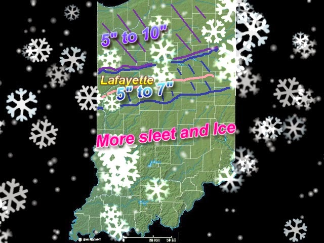
Again these numbers are far from set in stone! This is just a rough idea as of 6:30pm this evening. As this storm continues to develop I will have a much better grip on the situation and will have more solid data to give you. It's all gonna depend how much of this precipitation falls in the form of snow and how much of it falls as other types such as Sleet and Freezing rain. You can see by this model image below how close we come to sleet / freezing rain.
The weather will be different just a few short miles you travel north or south. A crazy winter storm this one will be! I will continue to keep my eye's to the sky and keep you posted! That's it for now bloggers. Stay Tuned!

Sunday, February 23, 2014

Below average temperatures return, Also a look at the potholes developing all over the city!

Cold weather is starting to return to the area after that brief warm up we saw last week. It felt nice while it lasted however now we snap back to winter. Our average high for this time of year is around 35*F degrees, We reached a high last week of 61*F degrees. Our weather is like a rubber band, The more you stretch it away from the normal the harder it snaps back! And that's what we're doing this week. We will be a good 11*F degrees below our average high and a good 13*F to 20*F degrees below our average low at times this week. From one extreme to another. Take a peak at tonight's outlook.
Tonight: We can expect a low around 8*F degrees with light winds between 5 and 10 mph. Skies become partly cloudy as we head into the overnight.

More cold polar air enters the area as we start our work week. We will see highs and lows below our average all week. Hopefully you didn't put away your heavy coats just yet. Winter continues to hold on with a tight grip! Take a look at this temperature model below looking into Monday, You can see that cold air starting to dip back down to Indiana. A sight we've become so familiar with.
As of now we can expect partly cloudy skies across the area as we head into Monday with more clouds moving in as we go through the day into Monday night / Tuesday. Some light snow showers will move into the picture as a small clipper crosses the area late late Monday into Tuesday. Snowfall less than an inch. Expect a low Monday around 14*F degrees with winds between 10 and 15 mph.

Tuesday and Wednesday will be two of the coldest days / night this week. Take a look at these forecast temperatures below.
Yes, break out the warm wool socks and kick on the fireplace! You're gonna need it lol. Look at that expected low Tuesday night of -4*F! Only climbing to a high Wednesday around 10*F degrees. Brrrrrrr is right. Stay warm bloggers!

Now something related to all the cold and snow we have seen this season, Potholes! Yes, believe it or not we have so many potholes in Lafayette, Indiana this year that I just saw Lafayette, Indiana on the weather channel as they were talking about how bad it is. That's crazy! I know crews are out trying to repair them as best as they can with temperatures still being so low. However it's gonna take a while. Teal rd, and 52 are horrible! So why is it that so many potholes develop after the winter? Well, I have your answer!
As seen above, Potholes occur as part of Indiana's freeze and thaw every year. Potholes begin after snow or rain seeps into the soil below the road surface, The moisture then freezes when temperatures fall below freezing, This causes the ground to expand and push up on the pavement. As the temperatures climb back up above freezing as they did last week the ground returns to normal level, However now there is a gap between the pavement and the ground below. Once a car drives over the cavity, the pavement surface cracks and fall into the hollow space leading to the birth of another pothole.

Pretty crazy to think about huh? All we can do is continue to be as careful as possible when driving and try not to damage our Vachel's in the presses! Have a great day bloggers. I'll check back again soon.

God Bless!

Thursday, February 20, 2014

After the storm, Reports as windy and chilly weather returns!

Alright, as the storms move out to the east we are finally starting to see the storm reports roll in. High wind reports that is! Lots of wind reports from these storms reaching 50+ and 60+ mph. Take a look at this below.
Remember that these are all (In storm) wind reports. You can see Fountain, county reporting small limbs down from trees along with shingles ripped off the roof, that wind gust was ukn. Another report from Terre Haute, of 60mph, Tipton with a 65mph gust, Boone coming in with a 60mph gust and Logansport, reporting a 58mph gust. I also saw that down around Indianapolis, recorded a peak wind gust of 70mph! And the reports continued to get high the more south you went as that is where the storms were stronger.

Along with all these wind reports in our area there were also 12 Tornadoes reported just to our west in IL. How crazy is that?!?

So why didn't the storms hold together and pose a tornado threat to our area? Well, it's like I said in my brief update around 6:pm. We were unstable however not unstable enough to support tornadoes this time around thank god! I was looking at LI values around 3.0 which isn't hardly unstable, along with Total totals around 46, They need to be around 45 for thunderstorms to form and around 52 or higher to support severe thunderstorms. Also our EHI was only around 0.0 to 0.5 and they need to be around 1.0 to 2.0 to support severe thunderstorms and tornadoes. So unstable we were however not as unstable as IL. As a result the closer the storms go to our area the less severe they became. Not to say they weren't strong! As we can see the wind damage reports above!
So the storms will continue to push off to the east as you can see the line above. And yes that cold front is pushing through dropping temperatures tonight into the upper 20s and giving way to a few possible scattered snow flurries. From one weather event to another, that's how we roll in Indiana :) Here's your Friday break down below.

Friday we can expect a cold start to the morning with a few scattered snow flurries possible before 10:am EST. Skies starting out mostly cloudy will try to break up as the day continues giving way to clearing / partly cloudy skies. Expect a high Friday of 43* degrees and a low that night of 29* degrees. BREEZY with winds between 20 and 25 mph gusting between 30 and 35 mph at times.

Highs will be in the lower 40s on Saturday as well falling into the 30s as we head into next week.
~~~~~~~~~~~~~~~~~~~~~~~~~~~~~~~~
~~~~~~~~~~~~~~~~~~~~~~~~~~~~~~~~~~~~~~~~
Flooding will be the next topic! All this melting snow and rain of top of that is causing problems on the rivers. 
The Wabash river is expected to crest Friday night into Saturday at around 18ft, Minor flood stage is at 11.0ft. If you live by the rivers please take note of this and be weather ready! If you see standing water on the roads and are unsure how deep it is please do as the saying goes and "Turn around, Don't Drown". The Wildcat is also being watched closely!
Latest observation of the wildcat creek near Lafayette, it was sitting at a little over 17ft. moderate flood stage starts at 15ft! This is already a problem and all this rain hasn't helped! So again please be aware and stay safe!

That's it for now bloggers. If you have any weather comments and would like to share please feel free to do so, Either in the comments section or on the JIWB facebook 


Have a great night bloggers. God Bless.

Update as of 8:08pm EST

The storms continue to push off to our east at this time. No severe weather was reported in Indiana yet however a lot of Tornadoes were reported with these storms in IL along with winds gusting to 60+ mph. We are looking good right now. I will try to have a more detailed post up soon. Thanks for reading bloggers!

Brow glad to see you back too! ;)

Update as of 6:09pm EST

I've been watching our current data closely over the past half hour, I'm not currently seeing our atmosphere terribly unstable at this time, Our TT index, K-index and LI, are not terribly unstable. Along with EHI and CAPE values. We do support Thunderstorms however I doubt we will be able to support Strong tornado producing thunderstorms at this time. Still watching closely!

Storm Update as of 5:51pm EST

That line of storms is still forming out in front of this cold front, You can see in this surface chart above. That warm air is pushing up into the state with all that cold air building to our west. Some of the storms in this line are strong / severe. Some high damaging winds have been reported to the NWS along with a possible tornado in western IL.

You can see the squall line in this closer radar image below.
The line is moving east north east. The red area is where the severe storms are currently located in this system. We will be cutting it close as this line moves through. I'm watching the radars closely for any change in track. Here is a look at my local radar below.
There are some severe thunderstorm warnings issued with this line as you can see above along with a few tornado warnings. There has been some radar indicated rotation with these cells. Our southern counties will have the highest risk of seeing some of these cells, Counties around Montgomery, southern fountain, and Clinton counties. Main threats would be Damaging winds, Hail Lightning, and an isolated tornado cannot be ruled out.

Watching the storms closely!

Just went through some quick data looking at our current EHI, LI TT and CAPE values. Areas close to home are a little unstable as a small squall line of storms is starting to form along the cold front to our west right now. I still don't look for us to see a wide spread area of severe weather however a stray strong storm or two cannot be ruled out as the weather makes its way into the state.
If you look at this image you can see the main line of storms I've been taking about already forming from TX, / LA, and spreading into KY, and southern Indiana. However this second line that is forming is north of LA in MO, right now. Currently nothing severe however they will pop a bit more as they move closer. Still expecting the main severe weather to be in southern IL and IN, and then more south of there however with EHI values around 0.1 to 1.0 we cannot rule out a possible stray strong storm or two. That's it for now bloggers. I'll check back when I can. Currently still at work! ;)

Wednesday, February 19, 2014

Latest on the developing thunderstorms Thursday!

Alright bloggers, I have been going through the latest weather data this evening and the new forecast for tonight / tomorrow is in. Let's get started.

As we head into tonight we will continue to see clouds move into the area as rain showers move closer during the overnight hours. As we move closer to 4:am ish we will see those showers starting in the western parts of the state. You can see in this radar image below how the system is already starting to develop.
We will see this warm front pass over the area giving way to a high tomorrow (Thursday) of 61* degrees! Because of this quick warm up with so much cold air following we will see a squall line of storms develop out in from of the cold front.
Good news for us is that I don't see the squall line actually developing until the cold front is at least half way through Indiana. Which means any severe weather would be south and east of our area. Take a look at this map below.
The national weather service is still keeping parts on Indiana in that severe weather risk area however as you can see they too believe it will be farther south and east of our area. I added the red line to this map to help show you where I'm currently thinking the main severe weather will develop.

Right now our main threats look to be:

 High winds gusting to 40 maybe even 40 + mph.

Heavy rainfall at times.

Flash Flooding do to warm temperatures and fast melting snow.

Isolated thunderstorms.
~~~~~~~~~~~~~~~~~~~~~~
~~~~~~~~~~~~~~~~~~~~~~~~~~~~~~~
Cold air will blast back into the area late Thursday night into Wednesday as that cold front passes through the area. This is also when the winds will be at their highest! Let's break everything down now.

Tonight expect a low around 34* degrees with winds between 15 and 20 mph. cloudy skies as rain moves in later tonight into Thursday.

Thursday we can expect a high around 61* degrees with a low Thursday night falling fast to 28* degrees. Rainy conditions starting early Thursday morning and going off and on through out the day. Scattered thunderstorms possible with high winds and heavy rain at times. Currently looking for rainfall between .50" and .75" inches with isolated 1" inch in areas. Anything severe is looking to stay more south and east of the viewing area at this time. Main threats will be Heavy rainfall at times giving way to flash flooding, Isolated thunderstorms and high winds!

Winds will be between 15 and 20 mph gusting to 35 and 40 mph!
~~~~~~~~~~~~~~~~~~~~~~~~~~~~~~~~~~
That's the latest for now bloggers. Stay safe and I'll check back soon. I'll be at work all day tomorrow. If I find time I will try to post a quick update. Have a great night!

Tuesday, February 18, 2014

Warm weather but not without a price!

Warm air is moving into the area over the next few days bloggers. However it doesn't come without a price! We will also be looking at a big melt down across the state causing flooding in areas as well as rain in the forecast on Thursday along with high gusty winds that could gust to 35 and 40 mph at times! Let's break things down.

First off we will look at Wednesday's forecast. It's looking nice! I'm expecting a high around 43* degrees with mostly clear skies across the area. Light winds between 5 and 10 mph with a low that night around 34* degrees. Late that night however is when we will see some rain showers start to move into the area into Thursday.
Above you can see this weather model looking into early Thursday morning. You can see the rain showers starting to move into the area around 6:am / 7:am EST Thursday. Heavy rainfall at times along with a few thunderstorms are possible. The rain becomes more area wide as we continue through Thursday afternoon and evening.
Above is looking into late Thursday. You can see this system starting to make it's way off to the east of Indiana. You can see how the precipitation is forming into a squall line. This is where I expect stronger storms to try and develop. High winds form on the back side of this system where you see all those tightly packed isobars. Winds Thursday will be between 20 and 25 mph gusting to 35 and 40 mph by that evening / night. We are in a slight risk for severe weather according to the NWS, however as I said above I feel that any severe weather to develop is going to be related to that squall line which currently looks like it will form just east of us. Still we will keep a close eye on this as new information come in. Anytime you have cool air in place followed by a quick warm up and another strong cold front on the back side, its something to watch! Nothing is set in stone.
You can see even in this severe weather risk map out of the NWS they even have it mostly for southern states and more east of Indiana.

Once this system pushes through the state and that strong low pressure and cold front passes we will be in for another cold windy blast.
Just look how tightly packed together those isobars are! Very windy as we head into Thursday night / early Friday. Cold air on the back side of this system with highs on Friday in the upper 30s/ low 40s and falling. A low Friday night in the 20s again with highs over the weekend in the middle 30s.

Main threats from this system for us will be,

High Winds of 40mph.

Warm temperatures melting snow in edition to rainfall.

Flooding do to rain and warm temperatures melting several inches of snow.
~~~~~~~~~~~~~~~~~~~~~~~~~~
~~~~~~~~~~~~~~~~~~~~~~~~~~~~~~~~~~~

We will be watching the local rivers over the next few days for sure! Right now the national weather service is expecting the Wabash river to crest this weekend at 10.9ft, Minor flood stage is at 11ft. This is dangerous if you live by the rivers. Be ready to take action!
So warm weather but not without a price! Stay safe bloggers. I will try to check back again soon. Have a good night!

God Bless.

Snowfall totals are in! Plus a warm up that could cook up some flooding threats across the state.

At work again, Just got the final numbers from around the area, Here is a look at last night's snowfall totals.

Remington, 3.8" inches.
Kokomo, 3.0" inches
Monticello, 2.0" inches
Lafayette, 2.0" inches
Attica, 1.5" inches

And then the more north you went the slightly higher the totals got, I have a snowfall report from Rensselaer, of 5" inches! Also reports of Thunder-snow through out parts of Lafayette yesterday afternoon! It was crazy.

Now thing next thing we will be watching are these mild temperatures working their way into the area. Tomorrow I'm looking for a high of 43* degrees with a whopping high on Thursday of 60* degrees! Followed by another mild high on Friday of 45* degrees. Melting snow will cause a problem with flooding in areas so please be ready! I will try to have more on this soon. Take care bloggers.

Monday, February 17, 2014

Looks like Lafayette, picked up 2.0" inches of snowfall out of this system, I will have more final snowfall numbers up later tomorrow afternoon. Roads are very slick this evening especially as we continue to head into the overnight. I was sliding all over trying to get home from the vet clinic tonight. Please stay home and off the roads if possible!
Sonny Williams shows us how things look on indiana route 8 just east of us 421. LaCross, indiana. very slick snow covered and icy! if you can stay off the roads tonight please do so. a big thank you to Sonny for sharing this photo with us. 

We will still look for that warm up over the next few days which will start our winter weather melt down. we will be watching what could be dangerous flooding in our near future! I will have more details on this as soon as I can. stay safe bloggers, I'll check back soon...

Quick update as the storm kicks in!

Here at work, Just looked through some data real quick. Still looking like wide area of 1" to 3" inches with isolated 2" to 4" in areas. This system isn't a big snow maker for many reasons, however one being that there isn't a whole lot of moisture with this system, You can see in this water vapor map below all the dry air behind this storm, Most of the time when we see big snows it's when we're pulling in moisture in from the golf. However not this time around.
You can see our timing was pretty much on target with this system, You can see it starting to make it's way across the viewing area. Rain sleet and snow. We have only seen snow in Lafayette and west Lafayette at this point and time. 
You can see we're right around that sleet to snow change over. I will continue to watch this system as much as I can, I'm still at work so I may not be able to update again however things are looking on point currently. Stay safe bloggers.

Sunday, February 16, 2014

Monday Sleet / Snow Update. Latest Data Is In!

Just went through the latest data this evening, It's looking more and more likely for a snow / sleet event rather then ice this time around. This is very good news. I know a lot of you are tired of winter weather however I'm sure you'd rather take snow / sleet then ice! The timing is still looking on target starting between noon and 2:pm EST Monday afternoon. Take a look at this surface chart below.
This is looking at Monday afternoon 1:pm EST. You can see the snow and sleet starting to make its way into the viewing area. That pink area is where we're expecting the mixed precipitation to form. as we head into the afternoon hours / evening hours we will see more wide coverage across the state. Take a look at this next surface image below.
You can see by 7:pm EST the snow is starting to make it's way out of the area. I currently think we'll stay mostly snow during this event however that sleet mix is possible. MOS models still showing snow sleet mix between 2 and possible 4" inches while the Bufkit models are expecting 1" to 3" inches. I think this is a good starting place for expected snowfall. wide areas of 1" to 3" inches with isolated 2" to 4" inches in areas.
Above is a look at the most current Bufkit data. You can see all those blue bars, This is showing precipitation in the form of snow. Still some small bars of sleet in this image however a mostly snow event. The more south you go the wetter the precipitation will be with some rain mixed in. Closer to the Indianapolis area. Be careful when out and about tomorrow bloggers. Have a great night and I'll check back again soon. I'll be at work all day tomorrow at the vet clinic, I will try to check back in as soon as possible!

Snowfall totals from last night. Plus a look at our next chc of snow before the snowy meltdown

I've got a look at your snowfall totals from across the area last night. Take a look.
We were calling for 1" to 2" inches for a wide area in central Indiana and that's just what we say. Starting a little after 9:pm EST last night most areas picking up right around an inch of snow. Lafayette seeing 1.2" inches and Kokomo, coming in with the highest with 1.5" inches.

More snow is still on the way! I have been watching the data closely as we head closer to our next system coming Monday afternoon sometime between 11:am and 2:pm EST. Yesterday it was looking like some freezing rain was possible with this approaching system however looking at the models today I think we have around a 10% chc or less of seeing ice. Some snow and sleet mixed however is likely. Right now both the MOS models and the Bufkit models are showing the possibility of 1" to 3" inches of snow / sleet from this storm. Take a look at this bufkit model below.
Keeping any ice out of the picture currently. We may still mix some rain in with this system especially the more south you go. However currently looking like a more snow / sleet event. I will continue to watch this as it develops.

Also still looking at that brief warm up as we head into next week. I have changed the highs a little bit putting us in the 50s on Thursday!
The meltdown will begin. It will be a soggy wet mess but the temperatures will be most comfortable. we will have to watch for flooding threats though! Be alert and stay safe.

Saturday, February 15, 2014

More Snow Before A Quick Warm Up

Well bloggers, this has been on of the snowiest winters on record here in Indiana! And the snow just keeps on coming. Anyone who knows me knows that this has been the perfect winter for me! Snow on the ground the whole season long. It just doesn't get any better then that. I know a lot of you are sick of it by now however. And in this post I have both good news and bad news for everyone who is wishing for some warmer weather. Let's get started.

First off we do have some more winter weather in store by as soon as tonight! As we head into the over night hours we can expect another small Alberta clipper to make it's way into the viewing area sometime between 9:pm and 11:pm EST. Not looking like a big snow by any means however another 1" to 2" inches is looking likely. Take a look at this precipitation map below.
This is looking into late tonight / early early Sunday. Right now I'm looking for those darker shades of blue to be in that 1" to 2" inch range with the lighter blues in that inch or less range. I'm agreeing with what the National weather service is forecasting below.
I really like the numbers. Expect a lot tonight around 17* F degrees with light winds between 3 and 5 mph.

Now the next system to be watching will be Monday afternoon! The timing is still out on this system as well as what type of precipitation could it will fall as. Some models are showing a good mix of both rain and snow while others are trying to mix in a little freezing precipitation as well.
You can see the type of precipitation forecast map above showing the chance of some freezing rain with this next system Monday. This is something we will watch closely. right now even if we do pick up some freezing rain I doubt it would be more then 0.10" inches.

The Bufkit models give up hope that we will see more of a rain snow mix rather then an icy mess at this time. And they usually do a pretty good job at forecasting winter weather.
You can see we're looking at all snow for Tonight into Sunday and currently mostly snow if you look to the left of this chart for Monday as well. This is something we will continue to keep a close eye on as we head closer to Monday.

Here's your quick cast below.

Tonight- look for more clouds to move into the area with snow showers starting between 9:pm and 11:pm EST. Show showers will go into early Sunday. Snowfall amounts between 1" and 2" inches. Winds light between 3 and 5 mph. Expect a lot tonight around 17*F degrees.

Sunday- look for cloudy skies to start the day with skies trying to become partly cloudy as we head into the afternoon / evening. Look for a high around 29* degrees with a low Sunday night around 19* degrees. Winds light between 5 and 10 mph.

Monday- a mix of precipitation moves into the area bringing rain / snow likely. Not completely ruling out some freezing rain at this time. New precipitation amounts between .25" and .50" inches. High around 36*F degrees with a low around 22*F degrees. Winds light between 10 and 15 mph.
~~~~~~~~~~~~~~~~~~~~~~~~~~~~~~~~~~~~~~~~~
~~~~~~~~~~~~~~~~~~~~~~~~~~~~~~~~~~~~~~~~~~~~~~~~~

So with all that talk of more winter weather where is the good news for everyone ready for a warm up? Well I got you covered!

Highs will start to go up as we head into next week. I'm seeing highs from the MOS models reaching the low to upper 40s likely between Tuesday and Saturday! Take a look at these numbers below.
That should give you all something to look forward too as we head through the next couple of days. Have a great weekend bloggers! God Bless.