Thursday, April 28, 2011

My Thoughts And Prayers Go Out To Everyone Affected In This MAJOR Severe Weather Outbreak!

Bloggers this tornado outbreak that went down yesterday is gonna go down in history!!! This is one of the biggest outbreaks to ever take place in the states! Take a look at all the tornado reports from just yesterday alone!!
165 tornadoes reported yesterday!!! WOW That is almost unheard of!! I pray that everyone is okay. I know there were deaths, and injuries, however my thoughts and prayers are going out to all these people!!! (GOD BLESS).

Take a look at this video in from Tuscaloosa, AL, Yesterday! These terrible storms that ripped through the southern states killed at least 248 people!


All we can do is pray for everyone!

Wednesday, April 27, 2011

Flooding Is The Big Threat Tonight!

Alright bloggers, We do have a tornado watch in effect for Tippecanoe, Fountain, Montgomery, Clinton, and Carroll, counties until 3:00am EDT. However after looking through our current data we really are rather stable. This watch is put into effect because areas from East Clinton, county and then more south and east of there has a chance for tornado development tonight. So to be safe the watch was extended to parts of the WLFI viewing area as well.
Right now I believe that Flooding is a much bigger threat for our area tonight rather then tornadoes! You can see in this image above how the real threat area I believe would be farther south and east.

As for the Flooding! We could pick up another Inch of rainfall through out tonight. Which wouldn't be good news for anyone who lives by creeks or rivers! The Wabash river is currently sitting at 16.7ft which is a good 5.7ft above flood stage. However this number will rise into the moderate flood stage very soon!
Click this image to enlarge.

Yes, the Wabash river is expected to crest on the 30th. Saturday at around 2:00am EDT at a moderate flood stage of 20.9ft. Which is 9.9ft above flood stage!! We have had well, above average rainfall this month and it just doesn't seem to want to let up!

Scattered showers (Hit and miss) as we head into tomorrow (Thursday). However the good news is Friday and Saturday are looking dry at this time! So if you don't already have outdoor plans set for this Friday or Saturday then MAKE SOME!! ;) lol Cause you'll wanna be out enjoying it. More rain / thunderstorms return by Sunday / Monday!

Again if your in an area that is known to have flooding please take note and be safe! I'll check back again soon. My thoughts and prayers go out to everyone being affected by the major severe weather outbreak in the south. And also to everyone in any flood areas!

God Bless!

Developing.

I'm working on a new post. It'll be up soon!

Even though we have a tornado watch in effect, Tornadoes will not be near the threat that Flooding will!!

DEVELOPING.....

Tuesday, April 26, 2011

Lifted Index

We're really starting to stable out a bit now that the line has went through our eastern counties. I'm now looking at (LI) values between -2 and -0 which is much better!
All Severe Thunderstorm warnings have expired in the WLFI viewing area
...THE SEVERE THUNDERSTORM WARNING FOR NORTHEASTERN PARKE AND SOUTHERN MONTGOMERY COUNTIES WILL EXPIRE AT 1000 PM EDT/900 PM CDT/...
...A SEVERE THUNDERSTORM WARNING REMAINS IN EFFECT FOR CLINTON...

SOUTHEASTERN TIPPECANOE...WESTERN HOWARD AND SOUTHEASTERN CARROLL COUNTIES UNTIL 1015 PM EDT...

There may be a brief gust just ahead of this line of storms between 35 - 45 mph near 50 mph. Otherwise main threat will be Lightning, Brief heavy downpours, and quarter sized hail!
...THE SEVERE THUNDERSTORM WARNING FOR SOUTHEASTERN FOUNTAIN COUNTY IS CANCELLED...
THE NATIONAL WEATHER SERVICE IN INDIANAPOLIS HAS ISSUED A


* SEVERE THUNDERSTORM WARNING FOR...


EASTERN CARROLL COUNTY IN NORTH CENTRAL INDIANA...


NORTHWESTERN CLINTON COUNTY IN CENTRAL INDIANA...


WESTERN HOWARD COUNTY IN CENTRAL INDIANA...


SOUTHEASTERN TIPPECANOE COUNTY IN WEST CENTRAL INDIANA...


* UNTIL 1015 PM EDT


* AT 930 PM EDT...NATIONAL WEATHER SERVICE DOPPLER RADAR INDICATED A


SEVERE THUNDERSTORM CAPABLE OF PRODUCING QUARTER SIZE HAIL. THIS


STORM WAS LOCATED 8 MILES NORTHWEST OF FRANKFORT...AND MOVING


NORTHEAST AT 40 MPH.


* THE SEVERE THUNDERSTORM WILL BE NEAR...


FLORA AROUND 950 PM EDT...


BURLINGTON AROUND 955 PM EDT...


GALVESTON AROUND 1015 PM EDT...
As you can see from Lafayette, east right along that line I posted in my last update we have yet another Severe thunderstorm waring in effect for.....

* SEVERE THUNDERSTORM WARNING FOR...


SOUTHEASTERN FOUNTAIN COUNTY IN WEST CENTRAL INDIANA...
SOUTHWESTERN MONTGOMERY COUNTY IN WEST CENTRAL INDIANA...
NORTHERN PARKE COUNTY IN WEST CENTRAL INDIANA...
* UNTIL 1000 PM EDT

This storm does have the potential to produce quarter sized hail!

New Data

As we have lost the daytime heating we had that one quick burst of a severe thunderstorm in the Carroll, county area and now our Lifted Index has become slightly more stable then it was just a few short hours ago. So this could change the severe threat area through out the night.
You can see we have went from an (LI) earlier this evening of -6 to now a current (LI) around -4 to -3. Which is slightly more stable then earlier.

So with that said, It is looking like the severe threat area tonight may be from Lafayette, east! Take a look.
Still I will continue to keep watching the data closely overtime, However right now this is the latest!
That Severe Thunderstorm Warning for Carroll, county has now been allowed to expire!
~~~~~~~~~~~~~~~~~~
~~~~~~~~~~~~~~~~~~~~~~~~~~~


We're starting to see those storms pop up in the WLFI viewing area. New Severe thunderstorm warning in effect.

SEVERE THUNDERSTORM WARNING FOR...


CARROLL COUNTY IN NORTH CENTRAL INDIANA... * UNTIL 900 PM EDT

This cell could give way to some small hail!

Looking South.

As you can see that purple area I posted in that last tornado outlook map in my last post, We are now starting to see some tornado warned cells enter that area. Above is the latest radar image at a closer range. Those purple boxes are the tornado warned cells. The Red is Severe thunderstorm warned cells.

Severe Threat Tonight!

Another shot at storms tonight bloggers! We have been put in a Tornado watch until 10:pm EDT tonight. This is for the whole WLFI viewing area.

Why could tornadoes become a threat tonight?? Well, as the sunlight continues to shine down on the area we're becoming more and more unstable. We are seeing current Lifted Index between -3 and -4. Anything lower then -4 is very unstable! take a look.

This chart is a look at our current Lifted Index. Again we're between -3 and -4 however weather models expect us to fall between -4 and -6! So we will be watching that closely.

Also we could see CAPE values as high as 2,500J/kg which would support dangerous lightning, and small hail in thunderstorms.

With how unstable we currently are, Looking at the Mesoanalysis data and the Significant Tornado layer we are seeing values around "1".

This could support brief isolated tornadoes in or around the area.

Above you can see where I would currently expect the best chance for tornadoes to develop in that Purple area however if we continue to become more unstable then this could change overtime.

We will just have to continue to watch this and as more data comes in I will do my best to keep everyone posted. So our main storm threats look to be:

Small Hail In Some Storm.

Dangerous Frequent Lightning, (As With Any Thunderstorm).

Flash Flooding Is A Threat As Flooding Is Already Occurring!

High Gusty Winds Of 60+ Mph Possible In Storms!

And An Isolated Tornado Cannot Be Ruled Out Just Yet...

I'll check back soon! God Bless.

Friday, April 22, 2011

Looking Rather Stable!

Good news is these cells are starting to break up even more the closer they get to the area. This is because we're just not really that unstable! This is great news for everyone who could do without strong storms tonight! ;) Take a look at the latest radar image below.
This image was taken at 11:20pm EDT 

I'm still gonna watch the radars and data over the next few hours just in case! You never want to take any chances with any kind of passing storms.

Yes, we do look pretty stable! But I'll still watch! ;)

Radar Update.

Radar Image Taken At 10:16pm EDT.....
As you can see above at this time all the real severe stuff is staying to our southwest as expected and we talked about in my last post. This is good news for us! However, we are tracking that cluster of cells still to our west moving east north east toward the WLFI viewing area. Currently there isn't any warnings within the cells however I will continue to watch them closely overtime as they continue to move closer!

Watching Storms Tonight!

Well, bloggers take a look at this satellite image below. You can see we are starting to see that line of storms develop off to our west at this time.
Yes, caps are starting to pop once again which means before long we will be tracking this weather in the WLFI viewing area. You can see the latest radar image below.
Radar image taken at 6:12pm EDT

Right now after going through the latest data it is still looking like the highest risk for strong strong storms is still gonna set up to our south! However we cannot rule out a few strong storms in our area as well.
You can see where I have the current highest threat area above. With it being that close to home we will be watching things closely. So what would our thunderstorm threats be as we head into tonight? Well, at this time I believe that heavy rain in storms are likely, With that being said we are continuing to watch the rivers as flooding is still a threat! Well, not really a threat as it's already happening in the area. These rains tonight won't help that.

Also with CAPE values between 1,000J/kg and 1,500J/kg I cannot rule out a few small hailers within the WLFI viewing area. Otherwise as with any thunderstorm lighting is a concern, And gusty winds outside of storms to 35 near 40 mph gusting higher in storms possible.

As for the tornado threat??
Right now I think the area to see the tornadoes would be southwest of the viewing area. And at this time the National Weather Service agrees as you can see above. So though we won't completely rule one out, It is still a "low" chance at this time!

I will continue to try and watch this system through out the evening and keep everyone posted the best I can.

God Bless!

Wednesday, April 20, 2011

Possible Light Frost Tonight. Another Chance At Storms By Friday!

That's right we will drop low temperature - wise tonight with a low around 33* degrees. Yes, near freezing tonight! So we have that chance in the area for some light patchy frost. If you have plants outside, then it's best to bring them in or at least cover the plants tonight! Warmer weather is on the way so hang in there.

Frost tonight is all we have to worry about weather - wise however as we head into tomorrow night we will see rain move into the area with another chance at another squall line by Friday evening / night! However before we see that we have some flooding to keep watch on. Take a look.
Click this image to enlarge. You can see the Wabash river is currently standing at 11.7ft which is .7ft above flood stage. Still it is expected to rise over time as the rain chances continue this week. We're expected to see the Wabash river crest tomorrow 8:00pm EDT at around 16.1ft. That's 5.1ft above flood stage! So if you live by the rivers this is something you should take note of.

So what is the weather looking like over the next two days? Well, here's the break down.

Quick Cast.....

Thursday we will look for Partly cloudy skies across the area for a good part of the day however more clouds will start to roll into the area by that afternoon / evening bringing some rain / thundershower chances by that evening / night into Friday. Right now nothing severe as the rain will be do to a passing warm front in the area. Rainfall between .25" and .30" inches. winds will be between 5 and 10 mph. Look for a high Tomorrow (Thursday) around 58* near 60* degrees with a low that night around 41* degrees.

Friday we will see rain showers / thundershowers through out the day! However we don't start to see a chance for severe weather until later that evening / night. That is when we will see that cold front start to move into the area which will allow for another squall line of storms to try and develop. Expect a high Friday around 59* degrees near 60* degrees, with a low that night around 53* degrees. winds between 10 and 15 mph gusting to 20 - 28 mph at times.
~~~~~~~~~~~~~~~~~~~~~~~~~~
~~~~~~~~~~~~~~~~~~~~~~~~~~~~~~~~~~
As you can see in this map above we are in a slight risk for severe weather come Friday! However its still a little early to see what our biggest threats would be. However at this time I see the biggest threat "area" being a bit farther south then the WLFI viewing area. Take a look below.
Inside the blue area is where I currently see the highest severe threat area setting up. But again it is still a little ways out so we will continue to watch for any weather changes to this developing system over time.

Here's what's causing this system below.
Much like the last storm we just had we will be tracking that warm moist air from the golf moving into the area first which is what will give way to our rain showers over Thursday night and through out the day of Friday.

Then the cooler air (Cold Front) will move into the area later on Friday night popping up another possible line of storms in the area. This is why we will again be watching things closely this week. Lots of weather to track! So be sure to keep it here at JIWB for the latest.

That's it for now bloggers. I'll check back again soon.

God Bless!

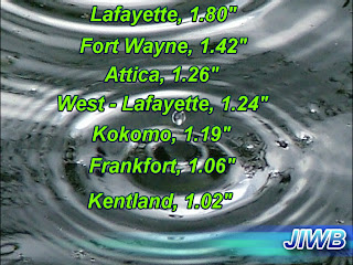
After The Storm!

Take a look at these final rainfall totals above from around the area last night. It seems no one has any less then at least an inch of rain after this one! If you have a garden then it definitely got it's watering out of this system! I hopped into the car last night and did a quick drive around however I couldn't find anything but a few small tree limbs down do to high winds and some localized flooding on some roads do to all that heavy rainfall! However once I got up this morning I found some deck tables and umbrellas blown into the fence of the garden.
Good news is that's about all the damage we seen in my neighborhood! However I do have many many high wind reports for all areas of the viewing area! And even some small trees down in areas of Lafayette!

Some steady wind gust reports from around the area around 40 mph were reporded last night. Take a look.

Kokomo, 46mph.

Fort Wayne, 45mph.

Lafayette, 44mph.

Remington, 44mph.
~~~~~~~~~~~~~~~~~~~~~~~~~~~~~

This was steady wind gusts. However higher peak wind gusts were reported. And those peak wind gusts are what is associated with these wind damage reports below.
All the blue areas are the high wind reports and or wind damage reports! Just amazing how much this storm report map blew up last night! (Amazing) Take a look at these wind reports below.
<>
 
CRAWFORDSVILLE MONTGOMERY INTRINITY MISSION FACILITY GARAGE AND SHED DESTROYED, TREE UPROOTED, TREES DAMAGED, FLAG POLE DESTROYED, SOME DAMAGE TO MAIN BUILDING


2 WSW RENSSELAER JASPER INLARGE TREE DOWN ACROSS SOUTH COUNTY ROAD 1200W BY IROQUOIS RIVER. TIME ESTIMATED.


LAFAYETTE TIPPECANOE INTREES DOWNED ON SOUTH SIDE OF TOWN.


MULBERRY CLINTON INTREES DOWNED.


MULBERRY CLINTON INGRAIN ELEVATOR DESTORYED. PART OF A BUILDING BLOWN IN . HOME DAMAGED.

CRAWFORDSVILLE MONTGOMERY INTREES DOWNED. ESTIMATED 80 MPH WIND GUST.


1 SE TWELVE MILE CASS INTV ANTENNA BY HOUSE BENT DOWN. ROOF OFF GARAGE.


As you can see lots of damage across the viewing area all because of those straight line winds. Some reports of winds to 80 mph as we expected as that line neared the area. That is as strong as a weak tornado.
We all knew we were in for it when we looked inside that line of storms. It had hail 1,00" to 1.50" inch in size. Flooding rains! As you seen damaging straight line winds! And the threat of brief rain wrapped tornadoes however none have been reported thank god! But those straight winds can be just as bad sometimes!

The bow echo was just crazy with this system. over 1,600 people lost power in Fountain, county alone! WOW. Over 555 lost power in Tippecanoe, county. And there are still many without power at this time!

 Still Without Power!


BENTON, IN 58

CARROLL, IN 4

CLINTON, IN 74

FOUNTAIN, IN 152

HOWARD, IN 10

MONTGOMERY, IN 312

TIPPECANOE, IN 187

As you can see we still have the clouds to deal with over the area today! However will take that any day over the storms! ;)
So I wish you all a blessed day! Take care and God Bless!

Tuesday, April 19, 2011

The Line Is Passed!


It's 11:18pm... I just got back from a drive around Lafayette. Nothing real bad thank god! Just some localized flooding on some roads such as Teal Rd, and some minor small tree limbs down in areas. The lightning was amazing while I was out. However it is dangerous with the moderate rainfall.. Roads are very slick with the pooling water!

That squall line is now out of the WLFI viewing area! It is continuing to push off to our east at this time. Still we have had many reports of high wind and hail in the area. Along with many many power outages across the area! One tornado reported close to home at this time! And that was in IL, by the Indiana state line. Take a look at the report.

HENNING VERMILION IL40318770POWER FLASHES ON GROUND AND SHERIFF REPORTED DAMAGE IN TOWN.


At this time I don't have any reports of tornadoes in the WLFI viewing area which is great. However we will wait a bit longer to see is any come it. Otherwise I have many hail reports!

HAIL 13 W WEST LAFAYETTE
88 INCH WARREN IN TRAINED SPOTTER

HAIL KINGMAN
U0.50 INCH FOUNTAIN IN TRAINED SPOTTER

HAIL WEST LEBANON
U0.88 INCH WARREN IN EMERGENCY MNGR
PEA TO NICKEL SIZE HAIL...RELAY OF SPOTTER REPORT

And also many power outages across the area. Take a look at the current amount of people without power from Duke energy below

BENTON, IN 71

CARROLL, IN 3

CASS, IN 18

CLINTON, IN 137
FOUNTAIN, IN 1981

HOWARD, IN 467
MONTGOMERY, IN 2053

TIPPECANOE, IN 2460

VERMILLION, IN 167
~~~~~~~~~~~~~~~~~~~~~~~~~~~~
~~~~~~~~~~~~~~~~~~~~~~~~~~~~~~~~~

Still some scattered thunderstorms are going to be the story tonight and I will continue to keep watching data and radars closely over the next few hours to be safe. Otherwise some flooding is possible as we still have moderate rainfall on the back side of these storms to deal with overtime!


Storms are just about through Clinton, Carroll, and Boon, counties! Click to enlarge the map above!
Duke Energy is reporting this many people without power below across the area!!

FOUNTAIN, IN 1625


HOWARD, IN 1


MONTGOMERY, IN 905


TIPPECANOE, IN 555


VERMILLION, IN 166
Storms are now entering Clinton, Carroll, And Boon, counties. The rest of the counties in the viewing area to the west of Clintin, carroll, and boon, counties are pretty much in the clean severe weather - wise!.

Clintin, Carroll, and boon, counties expect heavy rainfall. Frequent lightning, Small hail, brief rain rapped tornadoes cannot be rules out, and straight line winds to 60 - 65 mph!
Benton, Warren, Fountain, you are clean of severe!

Areas of Tippecanoe, Montgomery,counties we're almost finished! Clinton, Carroll, Montgomery,White, you can still expect winds around 50 - 60 mph frequent lightning, and brief rain wrapped tornadoes possible!
These stroms are blowing by!! Already half way through the Lafayette area!
It's in lafayette now!
Winds easily to 70 - 80 mph. The tornado siruns went off in Tippecanoe county however they do go off for straight line winds and because we do have the chance for a few brief rain wrapped tornadoes in the area! Still the biggest threat for a tornado is currently heading into Montgomery county!! If your in that area be aware!
This is gonna get ugly bloggers with straight line winds over 70 mph and brief rain wrapped tornadoes...
* TORNADO WARNING FOR...


BOONE COUNTY IN CENTRAL INDIANA...

SOUTHERN CARROLL COUNTY IN NORTH CENTRAL INDIANA...

CLINTON COUNTY IN CENTRAL INDIANA...

HENDRICKS COUNTY IN CENTRAL INDIANA...

MONTGOMERY COUNTY IN WEST CENTRAL INDIANA...

NORTHERN PUTNAM COUNTY IN WEST CENTRAL INDIANA...

TIPPECANOE COUNTY IN WEST CENTRAL INDIANA...

* UNTIL 1015 PM EDT

* AT 930 PM EDT...NATIONAL WEATHER SERVICE DOPPLER RADAR INDICATED A

SEVERE SQUALL LINE CAPABLE OF PRODUCING BRIEF RAIN-WRAPPED

TORNADOES IN ADDITION TO WIDESPREAD STRAIGHT LINE WIND DAMAGE.
Starting to see a lot of rotation in this cell heading toward Crawfordsville.
This is another area I'm watching for rotation and possible tornado development! This cell is heading east north east toward Montgomery county. You can see how it's starting to form a hook which is a good sign of developing rotation!

Covington, in the middle of this storm! Dangerous Straight line winds and brief rain wrapped tornadoes possible in this line! Winds of 70 - 75 mph!! And hail in Fountain county for 1" to 1.5" inches!
These areas of red is where some small brief rain wrapped tornadoes could be!
You can see the line is starting to cross the Indiana state line. I'm still seeing straight line winds of 70 mph. There is still a chance for some brief rain wrapped tornadoes in areas. Dangerous lightning and hail is also likely inside these storms!

Strong straight line winds are packed in this line of storms moving into Fountain, Montgomery, Tippecanoe, Warrenn, counties. Winds of 60 - 75 mph likely! Hail and frequent lightning also. These winds are the same as a weak tornado so stay away from windows and stay weather ready. If you have a Noaa weather radio then keep it handy!
TORNADO WARNING FOR...


FOUNTAIN COUNTY IN WEST CENTRAL INDIANA...

PARKE COUNTY IN WEST CENTRAL INDIANA...

VERMILLION COUNTY IN WEST CENTRAL INDIANA...

WARREN COUNTY IN WEST CENTRAL INDIANA...


* UNTIL 945 PM EDT/845 PM CDT/
* SEVERE THUNDERSTORM WARNING FOR...


BENTON COUNTY IN NORTHWEST INDIANA...


SOUTHWESTERN JASPER COUNTY IN NORTHWEST INDIANA...
* UNTIL 845 PM CDT...945 PM EDT...

* AT 740 PM CDT...NATIONAL WEATHER SERVICE DOPPLER RADAR INDICATED A


LINE OF SEVERE THUNDERSTORMS CAPABLE OF PRODUCING QUARTER SIZE


HAIL...AND DAMAGING WINDS IN EXCESS OF 60 MPH.
I just wanted to go ahead and let you all know the only way I wouldn't be updating is if power goes out! There have been wind reports of 70 - 80 mph in IL, from this same line heading tward our area.
TORNADO WATCH 157 IS IN EFFECT UNTIL 200 AM CDT FOR THE


FOLLOWING LOCATIONS

. INDIANA COUNTIES INCLUDED ARE


BARTHOLOMEW BOONE BROWN


CARROLL CLAY CLINTON


DAVIESS DECATUR DELAWARE


FOUNTAIN GIBSON GREENE


HAMILTON HANCOCK HENDRICKS


HENRY HOWARD JACKSON


JENNINGS JOHNSON KNOX


LAWRENCE MADISON MARION


MARTIN MONROE MONTGOMERY


MORGAN OWEN PARKE


PIKE POSEY PUTNAM


RANDOLPH RUSH SHELBY


SPENCER SULLIVAN TIPPECANOE


TIPTON VANDERBURGH VERMILLION


VIGO WARREN WARRICK

Here's the path of the storm! If your county is in the path then be ready! Right now as these storms are in IL, they are packing winds of 70 - 80 mph. Some rotation and tornadoes have been reported! Large hail and damaging winds! An isolated tornado cannot be ruled out if these storms continue on this path and don't show signs of weakening!

I'm not gonna lie. It could get nasty!

Gotta watch it CLOSELY!

This is the line in IL, that has given way to many tornadoes and it's heading our way! We need to be taking note of this line and watch it VERY closely! This line has a lot of rotation with it and has many tornado warnings issued as well. Take note and be weather ready...

Watch To be Issued Soon!

Just going ahead and giving you all the heads up of this possible watch to be issued for the area soon! There have already been many tornadoes reported in areas of IL, in that highest tornado threat zone map I posted in my last update.