Friday, December 31, 2010

Happy New Year!!! 2011!! And I Wish You All An Awesome One!

Happy New Year Bloggers! Yes, tonight is new years Eve and tonight we say goodbye to the year of 2010! A lot has happened this year. Some good and some bad. Now is the time of year that we continue to look forward and keep moving on! You gotta keep going! Keep looking forward to that next day, and always keep friends and family close to your hart!

We have a lot to talk about in this post bloggers! First lets go ahead and take a look at your forecast for later on tonight as we ring in the new year.

Tonight you can expect rain with a few thunder rumbles not out of the question. Between what rain we see tonight through Early Saturday morning I'm expecting between .25" and .50" inches grand total possible. Lows tonight will be around 35* degrees as the ball drops! Also expect winds between 15 and 20 mph with gusts to 25 near 28 mph possible at times!

now I'm not looking for rain all day on New Years Day. Some light rain early then becoming mostly cloudy in the morning hours followed by partly cloudy skies that afternoon / evening. It should make for a good start to the new year!

Now I have put together a little something to take a look back at some past storms we pulled together through in this year 2010. No this is not every storm! However just a quick look back. It's been a rough year but somehow we got by! And I thank God for that! God Bless you all. Have an awesome New Year! I'll be ringing it in at the bowling alley tonight with family! I See you all soon.

~~~~~~~~~~~~~~~~~~~~~~~~~~~~~~~~~~~~~

April 5th 2010.

Thunderstorms developed along a warm front across Central Indiana during the afternoon of April 5, 2010. These storms brought large hail and damaging winds to parts of the southern half of Central Indiana into the early evening.

Most of the severe weather that occurred was large hail. Below are some hail stones that fell near Paragon in Morgan county.

Hail from near Paragon - Click to Enlarge

June 12, 2010 Severe Storms

A line of severe storms marched across Central Indiana on June 12, bringing a tornado, damaging winds, and heavy rain.

Surface Map

Above is a surface map from 8:00 PM EDT June 12.

The tornado occurred in Morgan County, touching down at 8:26 PM and lifting at 8:33 PM EDT. The tornado was on the ground for 5.8 miles, had a width of 75 yards, and was rated an EF-0. Below are some images related to the tornado. Click any image for a larger version.

Tornado Track Path - Large Scale

Closer view of Morgan County Tornado Path

Tornado TrackCloser view of Tornado Track

Radar image at time of tornado touchdown

Storm Relative Motion Radar Image at time of tornado

Radar Image at time of TouchdownStorm Relative Velocity Image at Touchdown

After the storms passed, some witnessed a double rainbow. Below is a picture of the rainbow in Miami County

Rainbow

~~~~~~~~~~~~~~~~~~~~~~~~~~~~~~~~

June 14, 2010 Severe Storms

A line of severe storms moved across Central Indiana on June 14, bringing damaging winds and heavy rain.

The line of storms produced winds near 75 mph in some locations. An ominous looking shelf cloud preceded the strong wind as well.

Radar image at 8:03 PM

Above is a radar image of the storms at about 8:00 PM EDT. Shelf Cloud

Above is a picture of the shelf cloud as it moved in.

~~~~~~~~~~~~~~~~~~~~~~~~~~~~~~

Severe Thunderstorms and Tornadoes
October 26, 2010

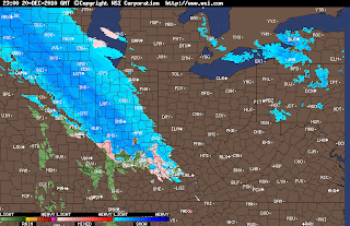
A record-breaking low pressure system over Minnesota pushed a strong cold front through the lower Midwest on October 26, 2010. The associated cold front aided in the development in a line of strong thunderstorms known as a squall line that stretched from northern Wisconsin through Illinois into Missouri during the early morning hours of the 26th. This line of thunderstorms pushed through the Northern Indiana office's county warning area during the morning and early afternoon hours.

The squall line produced widespread wind damage across the Midwest with wind gusts of 50 to 60 mph with some locations recording gusts up to 75 mph! In addition to the strong winds, some of the storms produced tornadoes in Wisconsin, Illinois, Indiana, and Ohio. The image below shows the storm reports as relayed to the Storm Prediction Center from the day.

NWS IWX has confirmed 13 tornadoes in their county warning area (CWA) in northern Indiana and northwestern Ohio.

Below is the radar loop of the entire event as the storms moved across the forecast area. In the image below the radar loop, numerous couplets were seen at multiple times along this line. Every couplet circled was possible of producing a tornado and many of these couplets did produce tornadoes at one time or another in several different counties. At this instance or shortly after, both the Kosciusko County EF0 and extreme northwest Huntington County EF1 touched down.

Thursday, December 30, 2010

The New Year Is Upon Us!!

The new year is upon us! Yes, tomorrow is New Years Eve. So what's in store weather - wise? Maybe your heading out to some kind of New Years Eve party! Well, lets go ahead and take a look at what the weather holds.

Right now I'm looking at rain still in the forecast as the Ball drops. Take a look at this latest Prog Chart for later on Friday evening around 7:pm EST.
Now believe it or not we do have a severe weather threat in store for many states here to end the month of December! Crazy right? So will Lafayette, have to worry about severe weather to ring in the new year? Well, using the map above you can see the red outlined area. This is where I would expect to see any severe weather outbreaks over New Years Eve. Right now I'm not looking for anything severe in the WLFI viewing area. Just rain and a few rumbles not out of the question. Let's go ahead and take a look at your quick cast below for more details.

Quick Cast.....

Friday / New Years Eve is looking wet at this time! Yes, I'm expecting to see some scattered rain showers through out much of the day. Rain showers will pick up as we head into the evening hours / night hours. Highs are looking to be around 57* degrees with lows that night around 35* degrees. Winds between 10 and 15 mph. A few gusts to 20 mph possible. Rainfall between a quarter and a half inch possible.

Saturday / New Years Day is looking like we will start out with some rain showers. This will go on into the late morning hours before turning mostly to partly cloudy by that afternoon / Evening. Highs will be in the upper 30s around 38* degrees and falling slowly through out the day as the cold front pushes through the area that night. Lows will fall into the teens around 17* degrees. Winds will be between 15 to 20 mph. Rainfall between a quarter and a half inch possible.
~~~~~~~~~~~~~~~~~~~~~~~~~~~~~~~~~~~~~
~~~~~~~~~~~~~~~~~~~~~~~~~~~~~~~~~~~~~~~~~


So as you can see I'm not expecting to see an all day rain event for New Years Day! Which is Great news! Also between both Friday and Saturday I'm expecting a grand total rainfall between .30" and .60" Inches possible with slightly higher amounts in thunderstorms. Here's a look at your New Years Eve forecast below.
Once we head into Saturday we will start to feel winter return! Yes, lows Saturday night will be around 17* degrees with 20s and 30s as we head into next week! I was able to get out to Armstrong before the cold returns and run 2 miles earlier this afternoon. I just couldn't pass up the weather lol. Now I'm looking forward to some family fun as I ring in the new year with my Aunt, Uncle, and Sister at Mike Albys Arrowhead bowl! Yes, we will be there from 10:pm til after 1:am. Should be a lot of fun! ;)

I may check back once more before I head out tomorrow. Have a GREAT AND HAPPY NEW YEAR Everyone! Take care and God Bless! :)

3.8 Earthquake Shakes Indiana Early This Morning.

Yes, areas of Indiana did in fact see and feel the earthquake that struck early this morning! Everyone is talking about it! Some felt it while others even myself slept right through it. This earthquake was felt all the way in MI, and OH. WOW! Take a look at where it all started.You can see in this map above that small blue box. This is the starting location of the earthquake. It is right around 15 miles east south east of Kokomo, Indiana. And around 50 miles north north east of Indianapolis. Or you could say in southeast Howard county right around Greentown, Indiana. This earthquake started around 7:55am EST this morning. Take a look how wide spread the earthquake reports are in this map below.Each and every light blue to a kind of dark blue box is an earthquake report! You can see how many people felt this one. Areas in IL, IN, MI, OH, Even a very few in KY. Most of everyone in the Lafayette, area reported only feeling Weak Intensity with no damage! Even areas right around the starting point of this earthquake around Kokomo, and Greentown, only reported Light Intensity with no damage! So thank goodness this has only been a weak earthquake. So how big was it? Well, it was a 3.8 Magnitude. It's always a top story when Indiana sees an earthquake. We usually see severe thunderstorms not LA, earthquakes lol. Here are a few post from the locals in the WLFI viewing area on this earthquake. Take a look.

Felt it in rural Francesville...Heard a rumble, boom and felt shaking for a few seconds...
`
Felt it in Rensselaer, thought I was going crazy, glad to know I am not lol...
`
felt it barely between logan and idaville, enough to make me think I was crazy and I just went back to sleep...
`
At work and my computer screen wiggled. Strange...
`
It was a loud bang and made my windows suck in and out, a alot of shaking...
`
thought I was losing it! I sure did feel it!...
~~~~~~~~~~~~~~~~~~~~~~~~~~~~~~
~~~~~~~~~~~~~~~~~~~~~~~~~~~~~~~~~~~~

Anyway that's whats been going on this morning. What a way to end the old year! ;) Take care bloggers. I'll check back later on with another look at your New Years Eve / New Years Day forecast.

God Bless!

An Earthquake Hit Indiana?

Details on the weak earthquake that hit Indiana this morning!

STAY TUNED!

DEVELOPING.....

Wednesday, December 29, 2010

A Look At Your Quick Cast.

A Dense Fog Advisory is in effect for areas in the WLFI viewing area. This Advisory is in effect from 7:pm this evening to 7:pm EST Friday.

A dense fog advisory means that visibility will be frequently reduced to less that one quarter mile. If driving be sure to slow down, Use your headlights, And leave plenty of distance ahead of you!

More information on this Fog Advisory click below.

http://forecast.weather.gov/showsigwx.php?warnzone=INZ029&warncounty=INC157&firewxzone=INZ029&local_place1=Lafayette+IN&product1=Dense+Fog+Advisory

~~~~~~~~~~~~~~~~~~~~~~~~~~~~~~~~~~~~
~~~~~~~~~~~~~~~~~~~~~~~~~~~~~~~~~~~~~~~
You can see the rain in the radar image above. This image was taken at 5:14pm EST this evening. Nothing major however some scattered rain showers will be likely tonight into Thursday. Let's take a look at your quick cast below for all the details.


Quick Cast.....

Thursday we will look for scattered rain showers off and on through out the day. Currently not looking for a lot of precipitation. Rainfall between a tenth inch and maybe a quarter inch possible. Highs will be around 44* degrees with lows not really dropping much! Lows around 44* degrees as well. Winds will be between 10 and 15 mph.

Friday (New Years Eve) we will look for scattered rain showers to bring in the New Year. Rain showers through out much of the day into New Years Day. Currently looking for rainfall between a quarter inch to a half inch possible. Highs will be very mild for this time a year around 56* degrees with lows that night around 35* degrees. Winds will be slightly breezy between 10 and 15 mph with gusts to 20 - 25 mph possible.

~~~~~~~~~~~~~~~~~~~~~~~~~~~~~~~~~~~~
~~~~~~~~~~~~~~~~~~~~~~~~~~~~~~~~~~~~~~

We will see the lower 30s return by closer to Sunday! That's the latest weather - wise for now blogger. Stay dry and God Bless! I'll check back again soon.

Tuesday, December 28, 2010

An Amazing December, Now Heading Into A Big Warm Up For The New Year.

Well, bloggers it's almost the new year! Yes, it's coming fast and soon we will be forecasting 2011 weather. This past month has been a pretty amazing one for anyone who has anything to do with weather. Weather watchers, Forecasters, And even Bloggers for that matter. We have not only seen below average temperatures all month of December but also well above average snowfall! And if your a snow lover then it was a dream come true! lol. Take a look at how much snow Lafayette, has seen grand total this December below.You can see Lafayette, usually averages around 6.3" inches of snowfall in the month of December. We have seen twice that amount! Coming in with a big 12.7" Inches! WOW we haven't seen that in a long time. To go along with these snowfall numbers we have also see temperatures around at least 18 degrees below average at times this month! One for the record books? ;) If not it's pretty close! Believe it or not we will go from the 12.7" inches of snow this month to possible record setting highs to start the new year along with some low land flooding possible! Check out what I'm talking about below.You can see we have an average high for this time of year around 34* and 33* degrees. We will be around at least 17* degrees above average come this weekend before cooling back down near normal by next Saturday. We have a BIG warm up coming as you can see above. For at least two or three days. With these warmer temperatures comes rainfall as well! So with rainfall and melting snow we will have to watch for some low land flooding possible over the next few days starting Wednesday night into Thursday. Here's a look at where the Wabash river currently stands at Lafayette.Now flood stage is at 11 ft, which currently we are not expecting to see. However it is expected to peak at around 5.1 ft so some low land flooding is not out of the question. We will have to continue to watch this as we head closer! So when can we expect our first round of rain this week? Lets go to your quick cast below and find out.

Quick Cast.....

Wednesday we will start out with some partly cloudy skies over much of the area. More clouds will move into the area as the day continues into the afternoon hours. Rain showers will start in around the late afternoon / early evening before 7:pm. Highs will be around 34* degrees with lows that night around 32* degrees. Winds will be between 10 and 15 mph with a few gusts to 20 mph possible.

Thursday we will see rain showers through out much of the day. I do expect to see a few breaks in the rain from time to time. Rainfall between late Wednesday into Thursday is expected to be between 0.25" and maybe 0.50" inches possible. I currently believe that most areas will pick up closer to that 0.25" inch mark. Highs will be around 42* degrees with lows that night around 41* degrees possible. Winds will be between 15 and 20 mph with a few gusts to 25 mph possible.
~~~~~~~~~~~~~~~~~~~~~~~~~~~~~~~~~~~~
~~~~~~~~~~~~~~~~~~~~~~~~~~~~~~~~~~~~~~~


We will be looking at scattered off and on rain showers pretty much from Wednesday night all the way through Saturday. So between Wednesday, Thursday, Friday, and Saturday we could be looking at a grand total rainfall between three quarters of an inch to an inch possible. We may have to tweak these numbers as we continue through the next few days. Again that's a look at the grand total rainfall for Wednesday - Saturday.

So that's the latest for now bloggers. Stay dry! And I'll check back again soon.

God Bless!

Developing Look Into Early January

Get ready because we are going to take a look into early January weather and see whats in store! Will new years be a total wash out? Will we set record highs? When will normal temperatures set back in?

All these questions will be answered later on tonight.

See you then!

Sunday, December 26, 2010

It Was An AMAZING CHRISTMAS! :)

WOW, What a Merry Christmas it was! I had a great time with my family! The snow was just the icing on the wintry cake! ;) It was around 32* degrees as we headed into the evening hours of Christmas eve so you can bet that I was out tossing snowball's around with my buddy Dobby! LOL. He is very much like myself. Loves the snow! And nothing was going to keep him from getting outside in the white stuff to play with his much loved Tennis ball! :)We were like to little kids having a great time! Though this storm gave us a hard time in the begging forecast - wise! It turned out to be a winter wonderland!
Once Christmas day rolled around my grandma got me a new video camera that also takes still pictures. She out did herself! And I thanked her a huge amount! She didn't have to get me such a gift. So I went out to snap some pictures of the Christmas lights before it was all over. Just take a look at the icicles in front of the lights! Just amazing!So how much snow did we see around the WLFI viewing area? Well here's how things looked in the Lafayette, area on Christmas eve.
Now lets take a look at all the final snowfall numbers!

Final Christmas Snowfall Totals...

Lafayette, 5.0" Inches.

West - Lafayette, 4.9" Inches.

Frankfort, 3.8" Inches.

Attica, 3.5" Inches.

Kentland, 3.0" Inches.

Remington, 1.5" Inches.
~~~~~~~~~~~~~~~~~~~~~~~~~~~~~~~~~~~~~
~~~~~~~~~~~~~~~~~~~~~~~~~~~~~~~~~~~~~~~

It turns out that we called this storm rather well this time around! :) I called for a wide area of 2" to 4" inches with isolated 3" to 5" inches here in much of the WLFI viewing area! Take a look at the amounts above. Lafayette, coming in with 5" inches. West - Lafayette only a tenth inch under that with 4.9" inches. Then around Frankfort, and Attica, they reported around 3" to 4" Inches of snowfall. As for the Newton, and Jasper, county areas I forecasted 1" to 3" with isolated 2" to 4" inches. And you can see Remington, coming in with 1.5" Inches! I think that's pretty good ;) Grand total Lafayette, had 8" Inches of snow on the ground counting both the old snow pack and the new snowfall. AMAZING! :)

So what's in store for the new year? Well, first lets look at your quick cast below for the next two days.

Quick Cast.....

Monday we will look for mostly cloudy skies to start things with a few light scattered snow flurries not out of the question. Little if any accumulation. We will become partly cloudy as the day continues. Highs will be around 23* degrees with lows that night around 13* degrees. Winds will be between 5 and 10 mph.

Tuesday we will look for partly cloudy skies through out the day. Highs will be around 29* degrees with lows that night around 15* degrees. Winds will be between 10 and 15 mph.
~~~~~~~~~~~~~~~~~~~~~~~~~~~~~~~
~~~~~~~~~~~~~~~~~~~~~~~~~~~~~~~~~

Now lets talk about what's in our extended forecast as we head closer to the new year! Take a look at this! Warm weather lovers I have a late Christmas present for you.((Image Is Looking At Wednesday 7:am EST))

You see that warm air area currently showing to our west? Well, that's about to move into the Midwest and give us very mild highs for this time of year in the middle to upper 40s near 50* degrees by this weekend! WOW. We go from 8" inches of current snow pack to possible 50* degrees! That's Indiana weather for you I guess. This mild weather won't last to long as cooler temperatures will work back into the forecast by the start of next week. However not before we see some HEAVY rainfall in the forecast for our New years eve into New Years day. Current models are showing possible 1.00" inch to 2.00" inches of rainfall! This is something we will have to watch closely! As for all your snowy questions for new years, Well, after going through the latest data it's looking like we will be way to warm and the heavy heavy snowfall will be well to our north and west! Rain is the story this New Years.
And as always I will continue to watch this forecast and give you all the very latest as I can! Until then I wish you all a very Happy New Year!
God Bless!

Developing Post

Hey everyone! I hope you all had an amazing Christmas!

I have a few things I need to finish up and get together then I will be back with a new update! Talking about how much snow was on the ground over Christmas and also a look into all your snowy / rainy questions over new years! ;)

Stay tuned!

Friday, December 24, 2010

A Winter Wonderland Is On The Way! :D

Good morning bloggers! It's Christmas Eve and I have an early christmas gift for all the snow lovers out there! I have gone through more data this morning and here's what my final thinking on this system is!

(Much or the same the Same) Yes, after going through more data I'm still seeing a wide area of 2" to 4" inches with isolated 3" to 5" inches!! It's going to be fresh powder for Christmas! This will start in around noon time give or take a little. Highs today will be around 32* degrees with lows for Santa fly's over around 22* degrees.

Christmas day we will still see a few light scattered snow flurries off and on through out the day with highs around 29* / 30* degrees and falling as the day goes. Lows will be around 16* degrees!

Now we do still have the Winter weather advisory in effect for much of the WLFI vewing area from 1:pm this afternoon to 7:am EST Christmas morning. So please if you happen to be out or still making your way home then please take your time and be careful. Roads will be snow covered and SLICK!

I will check back if needed. Until then have a wonderful Christmas Eve and Christmas! God Bless!

Thursday, December 23, 2010

Staying With My Last Update!

Alright bloggers, Here's the latest! Right now after looking through more data I can't find anything that will make me change the forecast from my last post! I still believe the last snow - cast stands! A wide area of 2" to 4" inches for the WLFI viewing area with isolated 3" to 5" inches possible.

The only thing that will be tricky will be the timing. Some models are showing this starting after 12:00pm EST while other say later on that evening. I believe sometime after 1:pm or 2:pm EST is our best bet. So again I'm sticking with my last update at this time.....

I will as always, continue to watch this system and I will check back with you all again in the morning. Be sure to check back for any changes to the forecast here on JIWB in the morning before the system arrives!

God Bless, MERRY CHRISTMAS!

I'll see you then!

Watching This One Closely For Any Changes!

We have Winter Weather Advisories issued for parts of the WLFI viewing area in effect from 1:pm Friday to 7:am EST Saturday..... See the link below for more details on this advisory!


Here's the system on radar we are tracking! Radar image taken at 4:53pm EST.....
Okay, I want to start by telling you all a little bit about this system! As you already know SOOOOO Much has changed over the past few days. From 5+ inches to maybe an inch. To 1" to 3" inches and now to whatever I have forecasted! This has been a crazy event and the models have been having a tricky time. Things are slowly starting to become more clear however nothing that I'm about to tell you is set in stone! Not with this system anyhow. No one has hit a snow forecast on the nose so far this year. It's just been that kind of season up to this point. Models have been underestimating the past few snowfall's by around an inch or two which doesn't make things any easier! Usually I feel that Alberta clipper systems are pretty easy to forecast however this year has been different. And this system we are currently tracking is no exception. I have been scratching my head so much with this one I wouldn't be surprised to have lost some hair over the past few days. lol. So I'm going to go ahead and post a snow - cast map now and if needed I will do one more update tonight after I get back from spending some time with my sister. So enough of this, Lets get to it! ;)


Above is my current thinking on this clipper system snowfall amounts for Christmas Eve into early Christmas morning. I have checked around after making my forecast and no one has the same forecast as another. Some are calling for 1" to 3". Others are calling for an inch and a half. And others are calling for 1" to 4" inches. However after going through the latest data I feel that a wide area of 2" to 4" inches is likely however I don't want to rule out a few isolated areas picking up 3" to 5" inches possible! right now the MOS models are expecting 2" to 4" inches. As well as some of the GFS models. Now if these models are right then GREAT! However the MOS models have been underestimating the past snowfall amounts by around an inch or so. That's why I feel we need to keep the isolated 3" to 5" inches in the WLFI viewing area possible!

Right now I'm expecting to see this snow start in somewhere between 10:am and 12:pm EST. somewhere around that time! We may see a few scattered light snow flurries tonight however the main event will start in later on Christmas Eve Day. This is how things are looking right now! But remember the forecast changed in a major way just a few days ago. Within a few short hours! So this is why I will have another post tonight when I get back from spending time with my sister. Should be sometime around 10:pm or so! Just trust me that I will have another post coming your way! ;) Now here's your quick cast below.

Quick Cast..........

Christmas Eve we will look for mostly cloudy skies to start things off in the morning hours. We will look for the snow to move into the area sometime between 10:am and 12:pm EST. Snow will go through out the day into early Christmas morning. Highs will be in the upper 20s to low 30s around 33* degrees. Lows that night will be around 23* degrees. Winds light between 3 and 5 mph.

Christmas Day we will look for scattered light snow flurries off and on through out much of the day. Expecting less then a half inch of snowfall. Highs will be in the upper 20s and falling through out the day. Lows that night will be around 16* degrees. Winds will be between 3 and 5 mph.
~~~~~~~~~~~~~~~~~~~~~~~~~~~~~~~
~~~~~~~~~~~~~~~~~~~~~~~~~~~~~~~~~~~~~

Be sure to check back later on tonight for one more look at this event before making our FINAL CALL!

See you then!

New Snowfall Numbers Are In!

I have gone through the latest data and new snowfall number are in! I told you all I would somehow find your white Christmas snow! Stay tuned! You don't want to miss this! ;)

DEVELOPING.....

The System Is Developing Nicely!

The snow event is still developing. Models are starting to get a better hold on whats coming! I will have more details on snowfall amounts and timing later on this evening. Stay Tuned!

Radar Image Taken At 1:20PM EST.

Still Tracking Snow!

Don't you worry yet bloggers! Snow is still in the forecast and we WILL see a nice Christmas snow! COUNT ON IT! ;)

Details will be posted later on tonight!

See you then.

God Bless!

Wednesday, December 22, 2010

Big Changes In The Christmas Eve Forecast!

Well, bloggers a lot has changed with this system. Yesterday evening models at 5:pm was showing a system coming from our southwest giving way to a 3" to 5" inch range of snow for our area! Then I checked the data again later on that night only to find that the models were calling for much much less snowfall for Indiana. Maybe only an inch! I thought "WHAT THE HECK IS GOING ON?". So I have been going through the new data as it became available to me and here is the latest!

The system we was expecting to move into our area from the southwest and give way to all that snow was the system that has been causing BIG PROBLEMS in California with lots of precipitation causing a number of floods and such! I'll break it down using the map below.
You can see the system on radar that I'm talking about. This system was expected to take the more northern track which would have given way to a possible 5+ inches of snow for the WLFI viewing area! However it is now looking like it will take a much more southern track over Christmas Eve. So we're not gonna see much from this one! So do we have any snow in the forecast for Christmas time? I think we still have a chance! Right now around a 30% chance for snow on Christmas Eve, Into Christmas Morning.Above is the new system we will be tracking! Yes, another clipper system will try and move into the area on Christmas Eve Day. The timing is still tricky at this time so we will have to fine tune that as we get a little closer. Right now it is looking like the heavier precipitation will be to our south. South of I74 at this time. However I'm not going to rule out a possible 1" to 3" inch range for much of the WLFI viewing area just yet! With how much things have changed overnight we will just continue to take this system one day and one model at a time before making any final calls! A white Christmas is still looking good! Keep hope snow lovers!! :) You gotta admit however that this is pretty amazing how MUCH this system changed and how FAST it changed! Indiana weather is not something you can turn your back on even for just a second! So with that said we will continue to watch this one closely and I will be sure to keep you posted! Now lets take a look at your quick cast.

Quick Cast.....

Thursday we will look for Partly cloudy skies in the WLFI viewing area through out much of the day. Some clouds will try and move in later on that evening / night into Friday. Highs will be around 30* degrees with lows that night around 23* degrees. Winds between 5 and 10 mph.

((Christmas Eve)) we will look for mostly cloudy skies with snow showers starting Christmas Eve, Day. Currently looking for 1" to 3" inch range. We will fine tune the snowfall amounts as we get closer! ((Nothing at this time is set in stone!))Highs will be around 31* degrees with lows that night around 21* degrees. Winds will be between 5 and 10 mph.
~~~~~~~~~~~~~~~~~~~~~~~~~~~~~~~
~~~~~~~~~~~~~~~~~~~~~~~~~~~~~~~~~~~


So that's it for now bloggers. I will be watching this developing snow for Christmas Eve, like a hawk. Be sure to check back here on JIWB for all the latest details as they become available!

God Bless, And Merry Christmas!

DEVELOPING.....

Latest update on the snow event over Christmas Eve coming up! A lot has changed! This is why we have been taking our time with this one!

Stay Tuned.

DEVELOPING.....

Tuesday, December 21, 2010

Snow, Snow, And MORE SNOW!!!!! YES! :)

Snow, Snow, And More Snow!!!!! That's what it has been all month and I have to say I HAVE BEEN LOVING IT!!!!! :) We had a nice snow event last night that's for sure. Take a look at these final snowfall numbers from around the area below.
Kentland, 4.0" Inches.

Frankfort, 3.9" Inches.

Attica, 3.5" Inches

Remington, 3.0" Inches

Lafayette, 2.1" Inches.

Logansport, 2.0" Inches.
~~~~~~~~~~~~~~~~~~~~~~~~~~~~~~
~~~~~~~~~~~~~~~~~~~~~~~~~~~~~~~~~~~~

You can see the highest amount coming in from Kentland, with 4" Inches and Frankfort, not far behind with 3.9" Inches! Amazing! We seen two more inches then what was expected because of a HEAVY SNOW BAND that move into the area last night. Take a look at this!This is a look at my Local Doppler Radar at 6:44pm EST Last Night. For you to see all this snow on this radar it has to be heavy! And this image above is nothing but SNOW! The darker the blues and then greens the heavier the snow! This gave way to dime and quarter sized snowflakes last night! This went on for a little while before slowing down and changing over to a light freezing rain by early morning Tuesday. We didn't have to worry to much about blowing and drifting snow do to the fact that this fell as a HEAVY wet packing snow! Great for snowmen! However you had to be careful shoveling that's for sure.

So do we have more snow on the way?? ((YOU BET!!!!!)) :)

Take a look at the current Christmas Eve snow outlook below.You can see that at this time I feel that a 3" to 5" inch range for much of the WLFI viewing area is a good starting point. As always I will fine tune this forecast as we get closer with a Snow - Cast map. This is a system coming from our southwest which means we need to watch it closely! When things line up just right we usually see our biggest snows from these kinds of systems. Right now some models are showing signs of the heaviest snow tracking just to our south however one thing to remember and watch when forecasting these kinds of systems is that the system usually moves 200 to 300 miles more north and west then what the models show! This is why I'm going to start out with a 3" to 5" inch range and take my time on this one! we can always add or take a little as things continue to become more clear!

Now let's take a look at what's in store weather - wise tomorrow (Wednesday) below.

Quick Cast.....

Wednesday we will look for partly to mostly cloudy skies however some scattered snow flurries / light scattered snow showers cannot be ruled out! Models expecting around 0.03" to 0.04" Inches of snow. (Less then a half inch possible) In most areas. Highs will be around 33* degrees with lows that night around 19* degrees. Winds between 5 and 15 mph.
~~~~~~~~~~~~~~~~~~~~~~~~~~~~~~~
~~~~~~~~~~~~~~~~~~~~~~~~~~~~~~~~~~

So be sure to keep checking back often bloggers to stay updated on the snow event for Christmas Eve! I will check back again soon.

God Bless, And Merry Christmas!

Still To Come.....

Working on the new updatre now. We will look at final snowfall numbers from last nights snow. And also take a look at how the system is coming along for Christmas Eve!

Stay tuned.....

DEVELOPING.....

Monday, December 20, 2010

A White Christmas Is On The Way!!! First Be Sure To Take It Slow On The Roads By Morning, Snow And Small Ice Accumulation Are On The Way!

Winter Weather Advisory For The Following Counties...
CARROLL-WARREN-TIPPECANOE-CLINTON-HOWARD-FOUNTAIN-MONTGOMERY-

THE NATIONAL WEATHER SERVICE IN INDIANAPOLIS HAS ISSUED A WINTER WEATHER ADVISORY FOR A MIX OF SNOW AND FREEZING RAIN...WHICH IS IN EFFECT FROM 1 AM TO 1 PM EST TUESDAY.

* ROADS ARE LIKELY TO BECOME SLIPPERY WITH A FEW HUNDREDTHS OF AN INCH OF ACCUMULATION OF ICE FROM THE FREEZING RAIN THAT FOLLOWS THE SNOW. THIS WILL MAKE THE TUESDAY MORNING COMMUTE DIFFICULT.

Yes, as you can see above we do have a few winter weather advisories in effect for some counties in the WLFI viewing area. Here's the break down on what we will see tonight into Tuesday.

Tonight we will start out with the snow showers across the WLFI viewing area with 1" to 2" inches of snow accumulation expected. Exact snowfall amount models are showing most areas with 2.5" Inches. This will try and change over to some mix / freezing rain between 4:am - 6:am EST early Tuesday morning.

Tuesday the mix / freezing rain will give way to less then a tenth inch of ice accumulation. Still we will need to take it slow on the roads! With this light ice accumulation on top of the snow pack things could be slick! Highs Tuesday will be around 36* degrees with lows that night around 23* degrees. Winds between 10 and 20 mph.

You can see the snow / mix in this radar image below.Radar image taken at 6:17pm EST.....

Now I can't have a blog update with out talking about the system coming on Christmas Eve! Take a look at this model image showing the system coming in Christmas Eve around 1:pm EST below.You can see the pink line I added to the map above. This is the freeze line and yes it is looking like it is staying south! This means we should stay ALL SNOW!!! YES!!! Fresh snow pack for Christmas Day! :) Currently it's looking like 3" to 4" Inches is a good starting point. However this will be more detailed as we get closer! A white christmas this year! I can't wait!

Stay safe bloggers. Allow extra time in the morning and take your time! I'll check back again soon.

God Bless, And MERRY CHRISTMAS!! :)

Stay Tuned.

Stay tuned bloggers. An update will be posted later on this evening.

Developing..........

Sunday, December 19, 2010

Snow, Ice, And Freezing Rain... And Still Watching for Snow Christmas!! :D

Are you ready for all the details on the Snow, Mix, And Freezing Rain on the way?? Well, so am I so lets get to it!

Quick Cast.....

Monday we will start out with a few snow flurries early, More steady snow showers will move in after 2:pm EST. Currently looking for 1" to 2" Inches of snow possible. This will continue through out the night before changing over to a mix early Tuesday morning. Highs will be around 31* degrees with lows that night around 29* degrees. Winds will be light between 3 and 5 mph.

Tuesday we will start out with a mix / freezing rain early. Currently looking for less then a tenth inch of ice accumulation at this time. Highs Tuesday will be around 34* degrees with lows that night around 23* degrees. Winds will be slightly more breezy between 10 and 20 mph.
~~~~~~~~~~~~~~~~~~~~~~~~~~~~~~~~~~~~
~~~~~~~~~~~~~~~~~~~~~~~~~~~~~~~~~~~~~~~~


Take a look at this precipitation model below.


This is a "Precipitation Type" model. This is looking around 4:00am EST Tuesday morning. You can see the change over from all snow to freezing rain isn't far off. I'm expecting the change to be between 4:am and 6:am EST Tuesday morning. Right now I believe that a 1" to 2" Inch range fits most of the WLFI viewing area. With less then a tenth inch of ice accumulation expected. Still things will be slick and you should always allow extra time!

I will be watching this as it unfolds. And I will keep you posted as needed.

Now how is the White Christmas forecast looking?
That's right it is still looking good! I'm still keeping a strong 65% chance for a white Christmas this year! I'm still tracking a snow system starting Christmas Eve with left over snow showers on Christmas Day! I don't want to get your hopes up just yet however this could be a 4+ Inch system! (I'm watching things closely).

I will continue to watch both systems this week and over Christmas and I will keep you posted! At this time a white Christmas is looking within our reach!! :)

God Bless!

Saturday, December 18, 2010

Watching Some Possible Freezing Rain Early Tuesday Morning. Also A Sneak Peak Into The Christmas Forecast!

I have been watching the models for the snow coming in Monday night into Tuesday. In my last post I said that this could still come in with some mixed precipitation, And after going through some more data it's still looking like a snow to mix of freezing rain event! I'm not going to rule out a possible 1" to 2" or 1" to 3" inch range for much of the WLFI viewing area before this system gives way to some freezing rain Tuesday morning. However I'm not going to set anything in stone just yet! We will get a few more model runs under our belt once again and check back. Here's a look at the system below in the latest GFS model. You can see where the freeze line is setting up!
Also I'm still tracking another system that could bring more snow over Christmas Eve into Christmas morning! Could we really be talking about a possible white Christmas?? It's looking like a 60% chance!! That's still better then half! ;) (KEEP PRAYING). This would be our first white Christmas in almost four years!
Above is just an early sneak peak into the Christmas forecast! Nothing is set in stone! A lot can change in a week's time. Still You heard it here first! However this is only if we stay all snow! Which models are showing a good chance for all snow at this time. However we do have a week to go! I will continue to keep watch on the Christmas System as well as the Monday night into Tuesday system. Stay tuned bloggers. I will be back here tomorrow night with all the details for Monday night into Tuesday!

Before I go! Lows tonight will be around 10* degrees with wind between 10 and 15 mph. So we can expect to see wind chills tonight around -7* degrees possible! Stay warm! ;)

God Bless! And Merry Christmas!

Friday, December 17, 2010

Looking Into The Next Alberta Clipper!

Lets jump right into it and take a look at the Quick Cast.

Weekend Quick Cast.....

Saturday we will see mostly sunny to partly cloudy skies through out the day. Highs will be cool around 23* degrees. Lows Saturday night around 11* degrees! With partly cloudy skies and no clouds to act as a blanket we will see cooler temperatures. Winds will be light between 3 and 5 mph.

Sunday we will start out with Partly cloudy skies. Clouds will be on the increase as the day continues. Becoming mostly cloudy / cloudy by that evening / night. Highs will be in the middle to upper 20s around 27* degrees. Lows Sunday night will be around 21* degrees. Winds will be light between 3 and 5 mph. I cannot rule out a few light scattered hit and miss snow flurries Sunday night into early Monday.
~~~~~~~~~~~~~~~~~~~~~~~~~~~~~~~~~~~
~~~~~~~~~~~~~~~~~~~~~~~~~~~~~~~~~~~~~


Now, The snow is back in the forecast! You may have heard this somewhere else already ;) Yes, I'm tracking another Alberta Clipper system to move in by the start of next week! Monday is looking like another snow tracking day!! YES!! :) But some things are currently still up in the air with this system. Take a look at one of the GFS models below.
This model is looking into Monday evening around 7:00pm EST. Now in this image you will see all the Blues, Greens, And Yellows. This is showing the Clipper System. So what are we watching? Well, you see that Pink line I added to this map? That is the freeze line. Also known as the 540 line. Usually any precipitation to fall to the north of this line falls as snow. And anything to fall south is usually in the form of rain. In the middle is usually a mix of both. So where this line will set up I'm still watching closely! Will we see snow from this? Yes, I believe so. And if we happen to stay all snow then we could be looking at 4+ Inches here in Lafayette! Still nothing is set in stone! I would like to get a few more model runs under my belt before I go posting a snowfall map. I will however say that I believe most of us have a good chance at the 1" to 3" / 2" to 4" inch range! But final snow - cast maps will be up soon!

Also Christmas is only 8 Days away!!! WOW it came on fast this year. It really needs to slow down. Christmas is and always has been my favorite time of year and I'm not ready for it to be over lol :) So back to what I was saying! I do have some models showing another possible system moving in over Christmas Eve and Christmas! Now it is way to soon to be giving any kind of amounts because some models are showing this system starting out as a mix with all snow showers by Christmas day! So many things could still change with this one. I just wanted to go ahead and give a heads up that we do still have yet another system out there! ;) However more details on if we will see a white Christmas will be posted soon.

Until then, With more snow back in the forecast and temperatures cold enough for icy roads! I found a video taken today that I thought you may find interesting! Take a look.


December 17, 2010 Brian Hardin, wanted to see if the street outside his home in Knoxville, TN was icy. I think he found out! ;) lol.

Have a great evening bloggers!

God Bless.....

Developing Snow Post.

A look at our next snowfall chance will be coming up later on tonight! Be sure to check back for all the details.

Have an awesome day bloggers!

God Bless.

Thursday, December 16, 2010

Almost Spot On!!

Okay bloggers, The final local snowfall numbers are in!! And I would say we called this one pretty close! Take a look at these reports from around the area below.
You can see the highest snowfall report coming in from Frankfort, with 2.7" Inches. This is just about as close as you can get! Exact snowfall models was showing me a possible 2.8" Inches of snowfall last night and Frankfort, picked up 2.7" Inches!! Almost spot on! That's why I put the whole WLFI viewing area in the 2" to 4" Inch range. You can see all the rest of the snowfall reports coming in around that 2" inch range as well!

Areas to our north, North of the viewing area will see less snow expected. I managed to get a picture from Downtown Fort Wayne. Take a look.
You can see they have much lower amounts. only around 1.5" Inches of snow currently on the ground. They are expected to pick up anywhere between a Trace to an Inch possible this afternoon. Roads are looking good in that area as well.

Now really most roads are looking pretty good at this time in the WLFI viewing area. However you still need to take it slow! Roads like Back or side roads are still snow covered. Along with neighborhood roads and parking lots. "Always Slick".
Above is an image taken in Lafayette, on some of the neighborhood roads. This is what they look like and pretty much what the side roads look like as well. So "Ice and snow take it slow".

That's it for now bloggers! Stay warm, Safe, And God Bless!

I'll check back again soon.

Snowfall Totals On The Way!

Going through a few things and then I will be back with your final snow storm snowfall totals right here on JIWB!

Stay Tuned!

God Bless...

Wednesday, December 15, 2010

Watching The Snow Move Closer.

Okay bloggers the snow is on the radar and will be moving into the area soon enough! As always lets start with the quick cast before we get to the snowfall amounts! Take a look.

Thursday we will look for scattered snow showers through out much of the day. Otherwise we will be mostly cloudy. Highs will be in the upper 20s around 27* degrees with lows that night around 15* degrees. Winds will be between 5 and 10 mph. This will make for a night time wind chill of 3* degrees!

Friday we will look dry with partly cloudy skies over the WLFI viewing area. Highs will be cooler in the lower 20s around 22* degrees. Lows that night around 5* degrees! Winds will be between 10 and 15 mph. This will make for a daytime wind chill of 7* degrees. And a night time wind chill anywhere between -10* to -13* degrees possible!
~~~~~~~~~~~~~~~~~~~~~~~~~~~~~~~~
~~~~~~~~~~~~~~~~~~~~~~~~~~~~~~~~~~~


Now lets take a look at the latest snow models! First take a look at the radar below.(Radar Image Taken At 5:54pm EST)

You can see the snow just to our southwest moving east north east slowly! This will move into the area by late evening / tonight. But how much snowfall are we talking about? Well, take a look at the latest snow - cast below.I have changed a few things in this map from the last time you seen it. You can see northern Indiana with lower amounts around a Trace to 1" possible. Then a 1" to 2" Inch range followed by that and the WLFI viewing area in the 2" to 4" Inch range. Now I have Lafayette, in the 2" to 4" Inch range, With exact snowfall models showing around 2.8" Inches possible. So I feel this wide range of 2" to 4" inches is pretty good!

I will continue to watch this and pop back in if I have to make any major changes! Hopefully we won't need to lol.

Until then... Happy Tracking!

God Bless.

Tuesday, December 14, 2010

A Bus Driver Hit A Snowman?? And A Clipper System About To Move Into The Area!

Well, bloggers we are about to talk about more snow in our forecast!! Yes, another clipper system will try and push through our area by tomorrow night into Thursday! How much will it bring? I will let you know! First a look at the Quick Cast.

Quick Cast.....

Wednesday
we will start out with some partly cloudy skies in the morning hours. Some clouds will slowly start to roll in come the early afternoon. We will look for snow showers to try and move into the area sometime after 8:pm - 10:pm EST. Expect highs in the lower 20s around 22* degrees and lows that night in the upper teens / low 20s around 20* degrees. Winds will be between 3 and 5 mph.

Thursday we will look for snow showers through out much of the day do to a clipper system that will push through the WLFI viewing area. We can look for highs around 29* degrees with lows dropping to 14* degrees that night! Winds will be between 3 and 5 mph.
~~~~~~~~~~~~~~~~~~~~~~~~~~~~~~
~~~~~~~~~~~~~~~~~~~~~~~~~~~~~~~~~~~

Here's a look at the current Snow - Cast below.You can see I have extreme northern Indiana in the 1" to 2" Inch range followed by the 1" to 3" Inch range. Much of the WLFI viewing area including Lafayette, is looking for that 2" to 4" Inch range at this time! I'm trying not to jump the gun this time lol ;) Then once you go more south, South of Indianapolis where they will see slightly warmer temperatures I have lower amounts around 1" to 2" Inches possible. This is how the amounts look at this time however I will continue to keep a close watch on this and I will have another update tomorrow (Wednesday) evening as needed.

We will also be tracking another clipper system later on Next week. It to could give way to some light accumulation! However let's just take this one system at a time! ;)

Now I found something that has to do with winter weather, Well, Kinda! lol. I wanted to show you all. A bus driver in Champaign-Urbana, IL resigned after officials with the transit agency saw this video of his bus running over a snowman in the middle of a street. Another vehicle steered around the snowman just before the bus hit it.

Take a look at this video below.


So I want to hear your take on this! So what do you think about the driver going into the other lane to hit the snowman? What was his thinking??

Have a great day bloggers! I'll check back again tomorrow (Wednesday) evening with the very latest on the clipper system..

Take Care... And God Bless!

Monday, December 13, 2010

Snow Pictures, Snow Video, Snowfall Amounts, So Much To Talk About!

Yes, lots of snow to track through this morning! Not as much as first thought however our second call was right on the money! Most areas in the WLFI viewing area picked up around around 2" and 2.5" Inches. I do have at least two reports of 3" to 3.5" Inches in areas up around Monticello. You can take a look at all the local snowfall reports below.
You can see Monticello, coming in with the highest this morning with 3.5" Inches. Just under them is Frankfort, with the second highest snowfall of 3" Inches. And then at the bottom is West - Lafayette, with 1.3" Inches of snowfall. We just had more dry air then first expected with this storm and most of the snow we was expected to see around the 4" Inches fell to our south in the Indianapolis area. Indianapolis, coming in with 4.0" Inches this morning. So where did all the REALLY HIGH snowfall amounts take place?? Take a look at these reports I have below! I really wish this was us! lol :)

Lake Effect Snow!

Westville, La Porter CO, 16.0" Inches.

La Porter, La Porter CO, 11.5" Inches.

Kingsbury, La Porter CO, 7.5" Inches.

North Judson, Starke CO, 10.5" Inches.

Valparaiso, Porter CO, 7.0" Inches.
~~~~~~~~~~~~~~~~~~~~~~~~~~~~~~~~~~~

Just Amazing!! If only we could see more lake effect snowfall in our area!

Well, we may have only recorded a snowfall in Lafayette of 2.1" Inches however Last night I recorded snow drifts of 17" Inches!! Most drifts today are around that 13.5" Inch range just under 14" Inches. Take a look at this one.
Is funny how much snow can drift, Even if it's only 2" Inches. This is the image all over the Lafayette, area. Just drift after drift! Some areas have nothing and other have near 17" Inches.
You can pick out some areas of grassy tops in this image below. This is what I mean by some spots have 17" Inches while others are almost nothing! But that's what you can expect with winds gusting to 37Mph!!Peak Wind Gust Reports...
Lafayette, 37 Mph.
Remington, 33 Mph.
Kokomo, 33 Mph.
Up around South Bend 38 Mph.
~~~~~~~~~~~~~~~~~~~~~~~~~~~~~~~~~~~~
It was no joke last night! You couldn't look up into the night sky without seeing just a blanket of snow flying through the air. The wind was so strong it took your breath away. I posted this blowing snow video from Lafayette, last night. Here it is again for yet another look.
Well, today we won't see highs get out of the teens so please be sure to really bundle up if your heading out! Also remember to always take your time. We don't need anyone slipping on the icy areas! Road crews are tyring to keep the roads clear by putting down salt. So please take your time on the roads as well!
I will be back later to talk about our next system that will move into the area this week! Details to come.
Take care, God Bless.

Sunday, December 12, 2010

17" Inch Snow Drifts Already!!

Well, I just got back inside from shoveling the path for the dogs! Small dogs don't like the snow lol. Also checked the current snowfall total. Lafayette, currently has around 2.0" inches. However with all the high winds blowing the snow has caused for some high snow drifts! That small 2" Inches has drifted up anywhere between 10" and 17" Inches! Yes, I have recorded 10" and 17" Inch snow drifts! Amazing!
.
You can see that most of the snow is trying to push east at this time. However we are still seeing some Lake Effect snow band that are still effecting some of our northern counties. Take a look below.This image was taken at 10:58pm EST...

You can see that band I'm talking about above. Some heavy snow in this band indeed. You can expect higher amounts then the 1" to 3" if your anywhere in these areas!

So the snow drifts hasn't been the only thing I have been recording. Wind chills already around 0* degrees in Lafayette. The winds will continue with occasional gusts to around 35 mph through out tonight into early tomorrow afternoon before starting to slow down a bit. However still gusting to 25 mph. Tomorrow we will see highs around 16* degrees with lows around 5* degrees. However we will be looking at daytime wind chills around -5* degrees at least. And night time wind chills around -20* degrees below! So this polar storm is far from over!

Again roads will be slick in the morning! Please allow extra time! And TAKE IT SLOW If you do have to go out!

Stay safe bloggers. I'll have your final snowfall totals posted tomorrow! So check back!

God Bless.