Tuesday, November 29, 2011

First Snow Of The Season! Be Careful Of Slick Roads Tonight!!

Today was a GREAT day if you're a snow lover in Indiana!!! We started out as rain showers then quickly changed over to all snow in the viewing area. I have many pictures and video to share with you all. But first lets take a look at how the weather is doing currently.
Above is a radar image taken at 8:00pm EST. You can see that most of that snow is now pushing off to our northwest and out of the viewing area. a few scattered light snow flurries are possible off and on tonight however no more accumulation expected! Otherwise we will look for partly cloudy skies as the night goes on.
We will have a cold cold low tonight in the 20s! which means roads are going to be dangerous tonight! All this snow and rain that made for a slushy mess on the roads will try to freeze overnight. So if you can stay home and off the roads then please do so! If you have to go out please allow extra time and take it S-L-O-W!!! Be safe is key!

Here's a JIWB video of the snow below. Also showing this evenings local snowfall totals and tonight's outlook.
Here are some more pictures from around the area below.

These first two are from Teri, in Lafayette, Indiana.
Pictures from Teri, In Lafayette Indiana (Above & Below).

Below is a picture taken in Lafayette.

This picture below was taken out of Mellott, in Fountain county.

Below is a picture taken in Lafayette.

Below is a picture taken in the Lafayette area from Larissa, You can see Tryst, and Shiloh, out enjoying the snow this afternoon!
Again please remember to be safe on the roads tonight, or if you can please stay home! Sun will return by Wednesday as clearing skies move into the area and a high of 39* degrees. We will be COLD again Wednesday night with a low of 18* degrees!

Take care bloggers!

Almost White Out In Lafayette!

Well, the rain has changed over to all snow much sooner then what was expected! We are now looking for double the amount of snowfall that was expected yesterday! You can see this picture taken in the Lafayette area looking south the almost white out conditions!!! Just amazing!! It is very dangerous and slick outside. Roads are in bad shape! Please take it slow or stay off the roads! Lafayette has 1" inch of snowfall on the ground, However 2.2" inches in the grassy areas! We could see 4" inches in areas especially up north before all is said and done!! I will have video and pictures up later on tonight.

Stay Safe! God Bless!!

Monday, November 28, 2011

Blustery Cold, With Minor Snow Accumulations Possible!

Cold, Blustery, Wet, and even Snowy! We have a lot of weather to deal with over the next day or two. Lets get started.
Above is a look at those cold temperatures moving into the area. This map is looking at 1:am Tuesday / early Wednesday morning. We will fall to a low Tuesday night of 22* degrees! With that cold polar air and rain snow mix, things will feel icy cold!

We are still tracking that low pressure system to our south that will continue to move north north west keeping us cold and wet! This system could even give way to some light snow accumulations in the area as we head into Tuesday evening / night. Check it out below.
As we go through the day tomorrow we will be tracking rain showers across the area, We could very well see some snow mixing in at times. Little to no accumulation will be expected during the daytime hours. As for rainfall we could see another .50" inches to .75" inches. As we head into the evening hours we will start to see more snow mix in before changing over to all snow later on that night (Tuesday Night).
Above is a surface chart looking into 7:pm Tuesday evening. You can see that rain changing over to snow. We will also see winds gusting as high as 30Mph. So things will be Blustery cold! Expect a high of only 41* degrees. However it will feel much colder with the icy winds and wet rain / snow mix!

As for the current thinking on snowfall, Take a look below.
Currently I'm looking for a wide area of .25" to maybe an Inch seen in the pink areas. With 0.50" or less just to the East of that pink area. The heavier amounts look to be to our northwest this time around. Currently looking for 1" maybe 2" inches in the white areas. Overall nothing to heavy this time around. However we still need to take it slow as this would be a very wet slushy snow!

Cold Wet Tuesday Is On The Way!

How much snow will mix with the rain as we head into Tuesday? And could there be accumulation? Details later tonight.

Sunday, November 27, 2011

Soggy Start To The Week! Blustery Winds Moves In!

That's right, I'm calling for a Hot Cocoa Advisory to be in effect from tonight through Early Wednesday morning, I'm forecasting Cold rain showers over the next couple days. Highs will be in the lower 40s with lows dipping into the middle 30s and even some 20s!! Not to forget wind gusts to 30 mph possible as we head into Tuesday! Brrrrrrr Is right! So do as posted and get that cocoa ready to go!

So whats the cause of this rain? Take a look.
Above is a look at the surface chart at 7:pm earlier this evening. You can see the rain over the state that has been effecting us over the past two days. This is because of that low pressure system to our south that will continue to track north north west over the next few days. Below is another surface chart looking into 7:pm Monday.
You can see we will be keeping those rain chances in the forecast as that pressure system move even more northwest. 
Above we're looking into 7:am Tuesday. That low pressure system will be just off to our west tracking northwest. Rain chances will still be in the forecast. However as we head into the overnight hours of Tuesday into Wednesday we could start to see some of this rain mix with some snow as well. Any mixed precipitation would be after 10:pm Tuesday. However no snow accumulation expected this time around. Just a wet soggy mess.

You can see models showing some of that snow trying to mix into the rain as we head into late Tuesday night below.
(See the blue mixed in the green).

Quick Cast.

Monday we will look for more mostly cloudy skies across the area with scattered rain showers as that low pressure continues to track near the area. Expect a high around 45* degrees with a low that night around 36* degrees. Winds will be between 10 and 15 mph with a few gusts to 20 mph possible.

Tuesday we will again look for mostly cloudy skies with some more scattered showers likely. Some of those rain showers could start to mix with some snow as we head into the overnight hours. No accumulation this time! Expect a high around 43* degrees and a low cold in the lower 20s! Around 23* degrees. Winds will be blustery between 10 and 20 mph gusting to 30 mph possible!

Rainfall between Monday - Tuesday between 0.50" inches and 1.25" inches possible.
~~~~~~~~~~~~~~~~~~~~~~~~~~~~~
~~~~~~~~~~~~~~~~~~~~~~~~~~~~~~~
Our average high for this time of year is suppose to be around 50* degrees. We will be running a good 5* to 7* degrees below our average high this week into next! We will also be below our average low as well. Our average low for this time of year is around 32* degrees. We will see a few nights fall into the middle 20s this week!

Stay Warm! :) God Bless!

Developing.....

A new post will be up later tonight talking about cooler weather to come! Be sure to check back!

Monday, November 14, 2011

Dangerous November Storms!!

A line of storms rolled through the area earlier this afternoon just after 3:pm EST. Dangerous Lightning, Small and large hail, Along with High damaging winds across the area of 60 + mph!! And even a few funnel clouds.

Take a look at this wide range radar image below taken around 3:20pm EST.
This line of storms was moving East North East at around 65 mph. You can see all the tornado warning boxes in this image in pink! We did have a funnel cloud reported in the Lafayette, area near the Tippecanoe mall! Here is that report below.

AT 3:47 PM EST...TRAINED WEATHER SPOTTERS REPORTED A FUNNEL CLOUD NEAR THE TIPPECANOE MALL NEARLY TOUCHING THE GROUND.

The good news is there hasn't been any reports of a tornado ever touching down in or around the area as if now! Still as we all know, sometimes straight line winds can be just as bad! Here is a closer more local look at that hook on radar below.
I have many storm reports from this system straight out of the national weather service below. Take a look.

Funnel cloud reported in Lafayette, Indiana near the Tippecanoe Mall.

Penny sized hail reported in West Lafayette.

Hail 1.75" Inches in size reported by an ambulance driver at the intersection of Jackson and Wabash in Frankfort.

60 Mph winds reported in West Lafayette.

60 Mph winds reported in Deacon, In Cass, county.

65 Mph winds reported in Terre Haute. Trees down do to wind!
~~~~~~~~~~~~~~~~~~~~~~~~~~~
~~~~~~~~~~~~~~~~~~~~~~~~~~~~~~~
As the storms started to move into Tippecanoe, county this afternoon I seen this huge Shelf cloud in the Lafayette, area. I took this picture at 3:26pm EST near Beck Lane and old 231. I've never felt so small lol. It was an amazing sight! People seeing a shelf cloud may believe they have seen a wall cloud. This is a likely mistake, since an approaching shelf cloud appears to form a wall made of cloud. However one way to help you tell is, A shelf cloud usually appears on the leading edge of a storm, and a wall cloud will usually be at the rear of the storm.
A sharp, strong gust front will cause the lowest part of the leading edge of a shelf cloud to be ragged and lined with rising fractus clouds.
In a severe case there will be vortices along the edge, with twisting masses of scud that may reach to the ground or be accompanied by rising dust. A very low shelf cloud accompanied by these signs is the best indicator that a potentially violent wind squall is approaching.
As you can see above, The cold front is continuing to move off to our east however its not going to cool us off to much come the overnight hours. Take a look below.
This is a look at our temperatures as of 6:00pm this evening. 40s are whats behind this cold front. And our low tonight is only expected to fall to 47* degrees with a high of 63* tomorrow. We will see cooler weather return however not until tomorrow night and then Wednesday with 40s as high and the low 30s as our lows!

I'm very glad everyone stayed safe this afternoon! If you have any reports or pictures please feel free to share them with me.. You can do so here on JIWB. Or comment and upload pictures to our Facebook page!! Just click on our Facebook logo on the side bar!

Talk about the storms!

Details on this crazy line of storms that pushed through the area will be up soon!! I have many wind, hail, and even funnel cloud reports! Plus I snapped pictures of a shelf cloud in Lafayette around 3:26pm this afternoon!! You don't wanna miss it!

Thursday, November 10, 2011

Graupel, And Persimmons! A Great Winter Day!

That's right, today we seen our first flakes of the season! This form of snow you see in the above picture is actually called graupel. Graupel forms when snow in the atmosphere encounters supercooled water. In a process known as accretion, ice crystals form instantly on the outside of the snow and accumulate until the original snowflake is no longer visible or distinguishable.

The coating of these ice crystals on the outside of the snow is called a rime coating. Now I know this looks a lot like sleet or hail! So how can you tell the difference? To tell the difference between graupel and hail, you simply have to touch a graupel ball. Graupel pellets typically fall apart when touched or when they hit the ground. Hail is formed when layers of ice accumulate and are very hard as a result.

And if you don't feel like calling it "Graupel" no problem! lol its also more commonly known as snow pellets, soft hail, small hail, tapioca snow, rimed snow, and or ice balls. lol.
You can see in this wide range radar image above taken at 3:26pm earlier this afternoon that the snow was so light radar had a hard time picking it up! Take a look at this closer image below.
Here is the local radar image also taken at 3:26pm earlier this afternoon. Lots of wide spread scattered snow flurries across the area. Temperatures did peak at a high of 40* degrees however not long before falling back into the middle 30s! A cold winter like day indeed..

Quick Cast.....

Tonight we will continue to see partly cloudy / mostly clear skies which will allow us to cool off big time as the night goes on!!! I'm talking about lows tonight in the 20s! 26* degrees! So be sure to bundle up as you head out in the early morning hours.

Friday we will see partly cloudy skies across the area with a high around 50* degrees and a low that night around 37* degrees. Winds between 10 and 15 mph.

We will see highs around 60* degrees as we head into the weekend, however average weather returns by the start of next week with 50s back in the forecast. November is going to be our up and down month temperature - wise.

With that said, I have more info about the winter ahead. If you remember in my last post we talked about what the weather models expect this winter to be like. As well as what Nature's signs have to say about things. And the two disagree on the forecast. Well I have another big nature sign for this winter! Take a look.
That's right! Persimmons!! It is said that if you cut open the seeds of a persimmon and find a spoon shape then you're going to have a winter full of shoveling heavy wet snow!! With that said, I have a report from someone out of Parke county below.

"I cut 6 seeds open yesterday and they all had very defined spoons in them. I picked the persimmons in Parke County, Indiana. I live in Vermillion County which is less than 10 miles from my home".

Yes, its another point for nature! All her signs are pointing to a cold snowy winter! Which leaves me to ask you one question! (Which side do you believe?) Nature? or the Weather Models?. I'm going with nature! There are just to many signs to dismiss, I'll have my shovel handy! :)

Details To Come!

We may have some changes to the winter forecast!! Details to come! You don't wanna miss this.. Also talk about the snow flurries we seen this afternoon..

Monday, November 7, 2011

What Could Nature Mean By The Words (Rough Winter)? Looking Into Indiana's 2011 - 2012 Winter Forecast.

It's been a little while bloggers, But I have managed to develop a look into the coming winter for you all. I have gone through a few weather models however this year I have done a lot of the forecast with almanacs and nature herself! So lets get to it so we can see how it plays out shall we?

For starters we will take a look into this very month, (November).
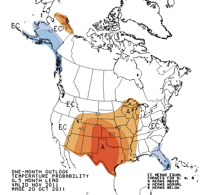
I have gone through data and it is seeming that we will be looking for the month of November to be more on the average / slightly above average side when it comes to the temperatures. With this La-nina jet stream pattern that's in place we will be looking at many temperature differences through out the winter, However I'll get more on that in just a bit. Take a look at this temperature map for the month of November below.

The below image is looking at the temperatures late November / December / January.

The average high for November is around 50* degrees. even as we end this week we could be seeing highs in the lower 60s again. Average low for November is around 32* degrees. So expect an average / slightly above average November.

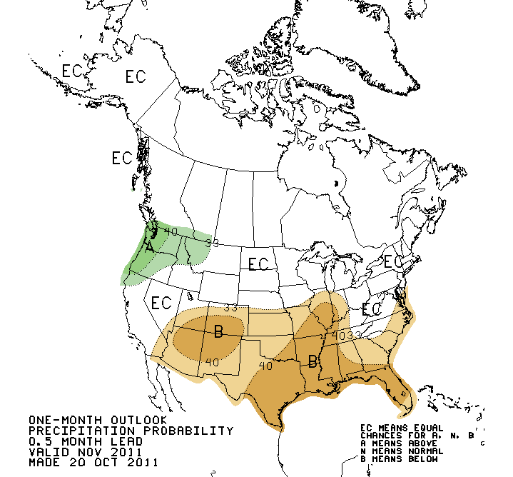
Precipitation on the other hand is looking around average to slightly below average this month. See this chart out of the climate prediction center below.

As we look into December things will be again (Up and down) temperature - wise. We could very well see equal days of both above and below average highs and lows through out the month of December! It will be a tricky month. Take a look at the temperature outlook from the CPC below.
This above image is a three month outlook, Dec, Jan, Feb...

As for the precipitation during the month of December, I see us around average / slightly above average however December will not be our snowy month this year. I see our snowiest months to possibly be late January into February. Here's the three month precipitation outlook out of the CPC below. This is looking into Dec, Jan, and Feb...
Though December is not looking like our snowiest month this season, Nature is calling for December to be a windy one! We could see some bitter cold wind chills this winter!

So why could temperature changes be so crazy this season? Bitter cold temps soon followed by mild temps? Well, it all has to do with our weak La-nina jet stream pattern.
You can see in this image taken in October the slightly cooler waters. Colors in Blues and Purples. This is the weak La-nina. Here is a look at the differences in the jet stream patterns during a La-nina event and an El-nino event below.

You can see the El-nino jet stream in the yellow, and the La-nina jet stream in the purple. With La-nina we see many troughs and ridges in the jet stream. This is what will continue to warm and cool us this winter! Cooler temperatures as a trough moves through while more mild temperatures during the ridge.

~~~~~~~~~~~~~~~~~~~~~~~~~~~~~~~

Now I know I have a lot of snow lovers out there as well that probably aren't to happy with this winter outlook. And I do apologize! However even nature is having a tough time giving hints as to how this winter will play out! Here's a look at the weather folklore side of things!

They say that when spiders spin unusually large webs it can mean a rough winter!
Three rather large webs found in September. All pictures taken on the same day..
Also during the month of September there were many squirrels gathering food frantically, leaving messes of shells everywhere! Which is also a sign of a rough winter ahead.
Pictures taken in September in the same day...
And to continue with natures signs of a rough winter! Its said that if the first week of August is unusually warm, then expect a rough winter ahead. So I went through some data of this past August and here's what I found.
The first week of august was running a good five to ten degrees above average! Could this mean a cold snowy winter? Or by the word "Rough" could it mean a mild November, Many temperature changes through out the season, Windy December, Overall a "Wet" winter, with around average snowfall for the season? Cause in my book that sounds pretty rough as well!

And last but not least, here is the look at the almanac's thoughts on this coming winter below.
You can see the almanac expecting us to be in that Average temperatures, Very white, Wet, category. Which I too feel we're in this category! However I feel it should look a bit more like this below!
With the Average Temperatures, and Very White, in the blue circle area.. And the Average Temperatures, and Wet, in the purple circle area. I think we'll have snows! However not like we seen last year!

Take care bloggers. Don't forget to follow JIWB on Facebook!