Thursday, December 31, 2009

A Blue Moon On New Year's Eve For The First Time In Almost 20 Years!! (Amazing) AND HAPPY NEW YEAR 2010!!

Hey bloggers. Well, it's New Years Eve and we are all ready to bring in the new year! 2010!! Woooooooo Whoooooooo :) I don't know anybodies plans however I went ahead and made your New years forecast anyway. We have our aunt and uncle coming over to play some games and watch the ball drop. And something I do every year is a Confetti drop. And this years is Bigger Then Last! I'm going to have a huge mess to clean up after everything said and done lol. I will try and take some pictures of everything after the mess :) lol. It should be fun! Now before we get to the Ball drop forecast let me go ahead and talk a little about the snow we have been tracking.

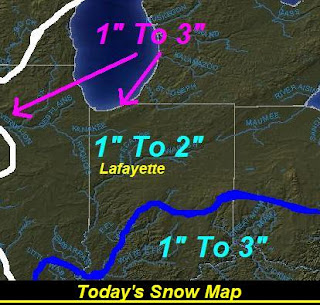
Right now I think most of us could pick up around an inch when everything is over, however some areas could pick up closer to two inches in spots. I'm not ruling that out! But most should stay around an inch. We could have been talking about 1" to 3" inches had we seen all this moist air move in earlier yesterday morning when the bigger bands were trying to set up to our west. Yesterday morning we seen temperatures around 32 degrees with Dew points around 23 degrees. That was way to dry for snow to hit the ground. however once I checked my data again last night, We had temperatures around 33 degrees with dew points around 30 degrees. This is much better for snow lovers! If only we seen dew points around this mark yesterday morning! :)

Now lets take a look at tonight's Ball Drop Forecast below.....That's right HAPPY NEW YEAR 2010!! Well, as you can see I'm currently looking for mostly cloudy skies however I cannot rule out a few light scattered left over snow flurries around the WLFI viewing area. I don't see it accumulating to much at all however snow flurries will be possible. We sure will be cold enough as I look for temperatures to be around 21 degrees around the time the ball drops. Also we can look for winds to be rather light between 3 and 5 mph with a few gusts to 10 mph possible. Over all it's not looking like anything bad! I think we bring in the new year on a good note. And I say this for more this one reason! Yes, we will have another treat here on New Year's Eve. That's right we will have our first Blue Moon on New Year's Eve in almost 20 years! This is pretty amazing.

Don't expect the Moon to actually turn blue, though. "The 'Blue Moon' is a creature of folklore," It's the second full Moon in a calendar month."Above: The full moon of Dec. 2, 2009, over Turan, Italy. Photographer Stefano De Rosa notes that the blue colors are cast by Christmas lights surrounding the pictured church.

"I remember the last time this happened," says professor Philip Hiscock of the Dept. of Folklore at the Memorial University of Newfoundland. "December 1990 ended with a Blue Moon, and many New Year's Eve parties were themed by the event. It was a lot of fun."

Most months have only one full Moon. The 29.5-day cadence of the lunar cycle matches up almost perfectly with the 28- to 31-day length of calendar months. Indeed, the word "month" comes from "Moon." Occasionally, however, the one-to-one correspondence breaks down when two full Moons squeeze into a single month. Dec. 2009 is such a month. The first full Moon appeared on Dec. 2nd; the second, a "Blue Moon," will come on Dec. 31st.

The modern astronomical Blue Moon occurs in some month every 2.5 years, on average. A Blue Moon falling precisely on Dec. 31st, however, is much more unusual. The last time it happened was in 1990, and the next time won't be until 2028.

So cue up that old Elvis record and "enjoy the extra moonlight on New Year's Eve," says Hiscock. "It only happens once in a Blue Moon."

~~~~~~~~~~~~~~~~~~~~~~~~~~~~~~~~~

Now the question is "Will we be able to see the Blue Moon tonight?" Well, we do have some cloudy weather in the forecast as you seen in the top map above. However I won't totally rule out the possibility for a few quick sneak peak breaks in the clouds. So maybe wwe will get lucky and see the moon even if it's only for a few seconds lol :) So what I'm saying is just go out and try to see if you can see anything. You could get lucky and see a quick break in the clouds! If so then ENJOY! Because like it says above "It won't happen again until 2028" ;)

Happy New Year Bloggers. I'm going to enjoy the day with my family. I'll check back soon..........

I wish you all another wonderful year and all the years to come! GOD BLESS!

Wednesday, December 30, 2009

New Update At Noon! Dry Air Cuts Back Snowfall Totals.....

Oak, the snow is moving into the WLFI viewing area however it's not looking to great at this time! As we looked at the radars in the morning hours we could see some heavy bands of snow developing to our west. However as this snow started to pass the Indiana state line it was slowly starting to evaporate right in front of our eye's. This is because we are still a little to dry to really support heavy snowfall. This dry air is going to really cut back our snowfall totals. Take a look at this radar image below.

Radar image taken at 11:57am EST.
You can see how everything is breaking up into a scattered light snowy mess. If we want big snowfall number we need to see more moist air. We had Dew points at around 20 degrees earlier this morning around 9:am which is pretty dry. Now they are starting to go up however they are moving up slowly. It is now noon and we are looking at Dew points around 23 to 24 degrees. With temperatures right around 32 to 33 degrees. There is a good nine degree difference between these two temperatures. Now as we see the Dew point and Temperature get closer this means we are becoming more moist and will be able to support some more snow. You can see the dry air below.
It's not to bad however it's dry enough. Now if you go and pull up a national radar something like http://www.intellicast.com/ or something you will see that the radar is showing lots of blue over our area. Well there is however most of that isn't hitting the ground! Now my radar image you seen at the top of this page is showing what's hitting the ground. And you can see it's looking like a scattered hit and miss mess at this time. Now I do think we will in time see things start to come together and we could pick up around an inch or so. However I don't see us getting much more. I don't want to totally rule out the chance for two inches however areas to the north and east of Lafayette, will have the better chance of 1" to 3" inches possible.

So Lafayette between 1" and 2" inches "possible" And areas north and east of Lafayette, and the WLFI viewing area could see closer to 1" to 3" inches possible.

Stay tuned bloggers. I'll check back as needed..........

Getting Ready To Track The Developing Snow System!

First off thank you bloggers for all the Nice comments about this blog. But if there is anything I can do to make this blog even better then don't be afraid to let me know! ;)

Oak we do have snow in the forecast for today starting in the late morning hours to the early noon hours. Right now I'm looking for snowfall to be around a inch. With slightly higher amounts in the southern parts of Indiana. We will look for snowfall between today through Tomorrow and maybe a little left over for the start to our new year. HAPPY 2010!! :)

Now I'm going to get a few things done and then I will be back this afternoon with more info as this system moves in. We will all track this system together here on JIWB.

Stay tuned!

DEVELOPING.......................

Tuesday, December 29, 2009

Snow Is Back In The Forecast...

Well, looking at this map above you can see we are looking for our Fair weather friend to move into the WLFI viewing area. And Yes, this means we will see some partly cloudy to Mosley clear skies move into our area as well. However this also means we will see a Cool Crisp Day! You can also see in this map above that we are inside that purple line. Which means another polar like day with highs in the low to middle 20s!Yesterday we were seeing highs in the low to middle 20s around 27 and 28 degrees however with winds blowing around 15 mph we had wind chills around 14 and 16 degrees! Brrrrrrrrrrrrrrrrrrrrrrrrrrrr is right! Well, this is kinda what we have to look forward to today, just a little lighter winds.

Also we have more snow in the forecast! Yes, snow lovers get ready to track another snow system from our south west. Currently this system isn't looking to great however we could very well see a few inches if everything goes as planed at this time. So how much could we see? Let's take a look below.Right now it's looking like we may see a few good bands try and develop that may give way to snowfall around 1" and 3" inches. However I will continue to watch this system closely for any changes! Right now this is the next chance at accumulating snow! This is looking to start sometime after 10:am EST Wednesday and then still see some left over snow showers on Thursday.

I'll have more on this coming up later on you can count on it! ;) Right now I have some things I need to get done and some work for the neighbors as well. Then I will be back here later on tonight with all the latest on not only this developing system but also your New Years Outlook! What kind of weather will we have in store to start 2010? :) I'll let you know.......... Sorry for the short blog post!

One more thing! I want to hear from all of you on this. Let me know. Do I show you all what you want to see on this blog? Do I break everything down enough and really explain what's coming or going on? If there is anything I can do better to make this blog better for you then please let me know! Or if everything is fine the way it is. I know I'm not anything like WLFI or as good as them but I will try my best. remember I do all this from my little lap top at home lol ;)

Please let me know your thoughts! Thank you ahead of time.

ALL COMMENTS ARE WELCOME!

Monday, December 28, 2009

The Snowfall Numbers Are In!

Radar image below was taken at 11:19am EST this morning.
You can see we have had some more light snow showers move into the WLFI viewing area today however they are currently to the east of the viewing area closer to the Marion, area. And then also snow to our north as seen in this image below.

Radar image taken at 11:19am EST this morning.Now we may still see a few light scattered snow showers move into the area however nothing will add up to anything as it would be really light. However I cannot rule it out. Our main thing to talk about today is the cold temperatures and wind chills outside! Yes, I have been recording temperatures right around 27 and 28 degrees however with winds blowing around 10 mph we have been feeling around 16 and 17 degrees! I went out earlier and had two sets of gloves on and my hands were still Freezing! But I LOVE this kind of weather! ;)

Real quick let's take a look at all the final snowfall totals from around the area after yesterday's snowfall.

Logansport, 4.0" Inches

Attica, 4.0" Inches

Rensselaer, 3.5" Inches

Remington, 3.5" Inches

Lafayette, 3.4" Inches

Otterbein, 2.8" Inches

You can see that Logansport, and Attica, comes in with some of the highest numbers around the area with around four inches of snowfall after everything was said and done. This has been our biggest snowfall of the season so far! And I'm ready for more! Bring it on Father Winter! :) lol.

Stay warm bloggers. I'll check back later on tonight with more.....

Icy Roads This Morning! Take It S-L-O-W!

Snow was the big story yesterday as it fell all day long! I myself really enjoyed just sitting by my window watching it as it accumulated. I did get some time outside in the snow enjoying, and also I was up outside after dark putting up my newest weather tools! Such as my new professional wireless weather center! Yes, my family got me an awesome gift! lol You can always tell us weather geeks! :) HA HA we always get some kind of weather tool as a gift! Which is always fine with me ;)

Now back to the weather talk. Lafayette, Indiana picked up a good 3.45" inches of snow from yesterdays system. This is our biggest snowfall of the season as of right now. Roads are still very slick this morning so I ask you all once again to please (Drive slow and allow extra time) With lows last night dropping into the low teens anything on the roads most likely has frozen into an ICY MESS!! If you don't have to go out this morning then stay home. However I know many of you can't do that. So please be careful!

I'll try to check back later on this afternoon with more snowfall totals from around the WLFI viewing area.
Now did you all enjoy your Christmas? My family and I had a wonderful Christmas Eve and Christmas day! And I have to say it was nice to get back to the Blog and see all the Nice Christmas wishes from my Favorite weather bloggers! As you can see in this picture above my sisters Chihuahua, Willie, was loving his gifts he got for Christmas. And also my Rat Terrier, Dobby below.
It didn't take long for Dobby, to go crazy over his stuff and start playing and chewing on the bones. lol I no sooner got his toys out of the packs and he started in.
We always have our dog's Christmas on Christmas Eve. It's just something we have always done and they seem to like it. I mean they're family to right? :) Even my and my sisters Parakeets got into it. Those birds are crazy! If anyone has ever had a parakeet then you know what I'm talking about. My parakeet has a mind of his own and he tells me what to do lol. It's like I'm his pet Ha Ha :) Just look at them below playing on the new swings they got for Christmas.
All and all it was a great time! We did nothing but lough with my Aunt and Uncle playing games half the night. And my Grandmas food was amazing!! And to answer Teri's question about if my cakes tasted as good as they looked? Well, all I can say is that nothing was left of them. They didn't make it past the 26th. lol. I'll take that as a good thing! ;)

So did anyone else get any weather tools for Christmas? Us weather geeks need to stick together lol :)

Now let's get to your quick cast blog cast below and see what's in store for the next two days!

Quick Cast.................................

Today we will look for mostly cloudy skies to over take the WLFI viewing area. We may see a few light scattered snow showers move in from the west as the day goes on however I don't look for any accumulation like what we seen yesterday. Maybe a dusting but not much more then that. Highs will reach into the low 20s with lows falling into the middle teens. Winds will be a little blustery between 15 and 20 mph with a few gusts to 25 mph possible. Wind chill for the daytime high will feel around 11 to 13 degrees. Wind chill for tonight will feel around 5 degrees or so.

Tuesday we will look for some partly cloudy to mostly clear skies as a high pressure system moves into the area. We will look for highs in the low 20s once again with lows falling into the low to middle teens. Winds will be more calm between 10 and 15 mph.
~~~~~~~~~~~~~~~~~~~~~~~~~~
~~~~~~~~~~~~~~~~~~~~~~~~~~~~~


So bloggers remember to be careful on the roads this morning and allow extra time! Becky, be careful on your route and stay safe!

I'll check back soon..........

Sunday, December 27, 2009

Watch The Roads Now Through Tomorrow Morning!

Icy Report!

Hey bloggers. We are currently at a temperature of 18.2 degrees and with lows dropping into the low to middle teens tonight we will start things out tomorrow morning slick and icy! Anything that may be left on the main and side roads will most likely freeze over night. Please take your time if heading out. Take it
S-L-O-W and be safe! That's all that matters!

Also I'm going to keep around a 15% to 20% chance for some light patchy fog early morning tomorrow. But right now the Ice is my main concern...

I'll check back later on tonight.....

Road Report As Of 2:28pm EST...

That's right I just got report that roads are VERY slick and snow covered! Even the main roads. As you can see above in this map we have reports of US 52 being covered with slush and snow. The side roads are even worse at this time being Snow covered! Roads are extremely slick and you need to be aware of this! If you don't have to go out then it would be best to stay off roads. However if you do have to head out then please allow yourself some extra time to get where you need to go and be careful with two hands on the wheel. Remember your winter driving safety tips!

Lafayette is currently looking at 3" inches of snow on the ground with still some light snowflakes falling from the sky! I still think we will pick up closer to three and a half inches or so. Some areas in the WLFI viewing area could pick up closer to four to four and a half inches before all is said and done! These areas would be closer to Montgomery, county and maybe Clinton, county!

Stay tuned bloggers. I'll check back as needed..........

Snow Report! As Of 1:20PM EST.....

ROAD REPORT! The snow showers have picked up once again this afternoon and as you can see the once cleared roads are now starting to become snow covered again! This is a picture of some of the side roads that have become very slick at this time! Some main roads may still be slick do to the slush that likes to become almost invisible in this kind of weather! Please take your time while driving and be careful! Two hands on the wheel. This is the latest radar image above. You can see the darker blues to our south in the Montgomery county area. This is where the heavier bands of snow are currently setting up. This image was taken at 1:13PM EST this afternoon. Lafayette has already picked up around 2.25" inches of snow and it's still coming down! I have gone through more model data and I think we could pick up around three inches maybe a little over at this rate! We will have to continue to watch things closely that's for sure! Take a look at these pictures from the Lafayette, area. It's a BEAUTIFUL snow. And we can all enjoy it if we remain smart and safe on the roads!Please stay safe bloggers and be careful if you have to go out! It is slick! And the side roads are still really snow covered as we seen at the top of this post. I'll continue to check back as needed through out the day! At this time this is our biggest snowfall of the season! WOOOOOO Whhooooooooo!! :D lol.
Stay Tuned!

Many Things To Talk About Today And Tonight!

WINTER WEATHER ADVISORY

CARROLL-WARREN-TIPPECANOE-CLINTON-HOWARD-FOUNTAIN-MONTGOMERY- BOONE-TIPTON-HAMILTON-MADISON-DELAWARE-RANDOLPH-VERMILLION-PARKE- PUTNAM-HENDRICKS-MARION-HANCOCK-HENRY-VIGO-CLAY-OWEN-MORGAN- JOHNSON-
INCLUDING THE CITIES OF...LAFAYETTE...FRANKFORT...KOKOMO...
CRAWFORDSVILLE...ANDERSON...MUNCIE...INDIANAPOLIS...TERRE HAUTE

...WINTER WEATHER ADVISORY NOW IN EFFECT UNTIL 1 AM EST MONDAY...

~~~~~~~~~~~~~~~~~~~~~~~~~
~~~~~~~~~~~~~~~~~~~~~~~~~~~~~~~


FLOOD WARNING

...A FLOOD WARNING CONTINUES FOR PORTIONS OF THE FOLLOWING RIVER...
WABASH RIVER...


THIS LATEST ROUND OF FLOODING IS BEING CAUSED BY HEAVY RAINFALL OF 1
TO 3 INCHES THAT OCCURRED IN EASTERN ILLINOIS AND WESTERN INDIANA ON
WEDNESDAY.


FLOODING WILL AFFECT SOME LOCAL RIVER ROADS...SOME RIVER CABINS AND
COTTAGES...LOW BOTTOMLAND AND RIVER PARKS. THE MINOR LOWLAND
FLOODING WILL END IN THE LAFAYETTE AREA BY MONDAY...AND END AT
TERRE HAUTE ON WEDNESDAY. LOWLAND FLOODING WILL LAST UNTIL ABOUT
THURSDAY IN THE HUTSONVILLE AND RIVERTON AREAS.

~~~~~~~~~~~~~~~~~~~~~~~~~~~~~
~~~~~~~~~~~~~~~~~~~~~~~~~~~~~~~~~


There is a lot to talk about today! Snow moved into the area last night and is still effecting us at this time. Lafayette has picked up 1.75" inches of snowfall as of now! We can look for snowfall through out much if not all day. Also watching the area rivers closely as you can see in the massage above!

We will continue to watch things closely. Most roads are looking good snow - wise however still take it slow! I will check back soon with stories from our wonderful Christmas. I hope you all really enjoyed yours!

Stay Tuned bloggers. I'll check back with much more soon.....

Thursday, December 24, 2009

HAPPY BIRTHDAY JESUS!! :) AND MERRY CHRISTMAS!!

Merry CHRISTMAS Bloggers!! Yes, it's Christmas Eve and I'm in a GREAT mood! :D We have a lot of weather going on in the area today through Christmas that's for sure! We have Icy weather! We have Rainy weather! And we have Snowy weather! We have it all. Yesterday we seen a little rain and even some freezing rain in the morning hours however it didn't amount to much which is always good new when it comes to freezing rain. However more of our northern counties seen the freezing rain. Some ice in trees was reported. Well, we could see a little bit more of that today. However it will be more likely in the northern counties then us in the Tippecanoe, county and around areas. The icy line had been staying right about the white county area and north yesterday! This is where I look for the icy mess to stay for the most part however as the day continues we will start to see that icy line lift north and become a mostly rain event in the WLFI viewing area. The good news is I look for little to no Icy accumulation. However heavy rain showers will move into the WLFI viewing area as the day continues. We will look for rainfall amounts between a half inch and three quarters of an inch possible. And WINDY as well. But I'll get to that in just a minute.

Now I may have a little something that should slow people down just enough to enjoy it and remember what Christmas is all about, and that's what counts. I think we will start out Christmas morning with a wintry mix of rain and snow. Then as we head into the Afternoon hours we may see that mix change over to all snow and watch some flakes fall from the heaven above! It's not a white Christmas however that would be really Beautiful to see! So I'll keep hope for that! :)

Christmas Quick Cast.........................

Christmas Eve we will watch more icy mixture to the north from White, county north of there. I don't look for much in the way of ice accumulation which is great news. As the day continues we will watch that lcy line move to the North of the viewing area. We will also watch the rain showers continue to get heavier as the day goes on. I expect rainfall between a half inch and three quarters of an inch possible. It will be WINDY as well! We will look for winds blowing between 20 and 25 mph gusting to 30 or 35 mph at times. Highs will be in the upper 30s to low low 40s maybe! Lows will in the low to middle 30s.

Christmas Day we will look for some mixed precipitation in the morning hours. Then as we head into the afternoon hours we will start to see that precipitation change over to all snow possible. I don't look for any real accumulation however some nice snow showers will be nice on Christmas Day that's for sure! ;) In the morning we could pick up another quarter inch of rain possible before we change over to some snow that afternoon. Highs will hit in the middle to upper 30s and then start to fall from then on. We will see lows drop into the teens as that cold air pushes into our area. More WINDY weather as winds look between 25 and 30 mph gusting between 35 and maybe 45 mph at times. Now the best chance for these high gusty winds will be between 8:00pm Christmas Eve, through 1:00pm Christmas Day.
~~~~~~~~~~~~~~~~~~~~~~~~~~~
~~~~~~~~~~~~~~~~~~~~~~~~~~~~~~~~

As you can see there is a lot going on right now in the Weather world! :) So if your traveling be extra careful as it will be a wet windy trip! Stay safe and get to where you need to go in one piece!

Man I'm tired and still have more to get done! Just take a look at what I have been doing the past few days below.

That's right! I'm in charge of the goodies for Christmas eve. LOL It's a good thing I have fun massing around with cakes and such. :) My Mom, is amazing at art and paintings and I have done my far share as well. However I have always liked to play around with this kind of stuff above more then holding a paint brush. lol.And I think people like this a little better because they get to eat all my beautiful hard work after lol :) Oh well! Now once I'm finished posting this blog I have to head back to the kitchen to make who knows how many cookies that my Aunt wants done. gotta get all this stuff ready before everyone gets here! Then I Can relax with my wonderful family and enjoy the rest of this great and Merry CHRISTmas.

It's gonna be great and I'm not the only one ready! You can see my Grandma's dog Pickles, below. :) Ha Ha :)She's ready to deck the halls! :D Ha Ha Ha. Believe it or not she LOVES this Santa hat! No kidding! So I just had to get a picture and post it here on JIWB. I thought you all would get a kick out of it at least! :) She's a cute one that's for sure...

Well, I wanna wish every one of you a Very MERRY CHRISTMAS and a Blessed CHRIStmas this year and all the years to come. Please stay safe and stay blessed. Let's let God guide us with his light of love!

I will check back after Christmas with all the details on your new year forecast! But first lets all enjoy Christmas. :)

Thank you for reading. GOD BLESS! And MERRY CHRISTMAS!Happy Birthday Jesus.

Wednesday, December 23, 2009

Watching The Icy Weather.

Yes, there is an Ice Storm Warning in effect for Newton, and Jasper, counties until 8:am CST Christmas Eve Morning. This is because it could be possible for ice to accumulate between one and three tenths of an inch.

We will see this ice line start to rise to the north of the WLFI viewing area tomorrow. Then rain moves in on the back side into Christmas morning followed by a mixture. The maybe some snow showers Christmas afternoon.

I will have all the details coming up here on JIWB tonight at 12:03AM EST!

Be sure to check back! ;)

We Got An Early Christmas Present! :)

Well, this first snow of the season yesterday was a HIT that's for sure! Everyone was out around the area with the shovels. No they didn't need to shovel much but if you ask me they were all out just to enjoy the snow! :) I know I did lol. And my pictures show it below.
After doing all the updates early yesterday morning and then the road report I thought I would use what extra time I had to mess around outside and see what I came up with. As you can see the Colts was the first thing that came to mind lol. This stayed up for a little while however it soon fell apart later on that evening :( lol :) And I also found out a little something cool about snowmen! :) See if you can see below.

I snuck up behind him and look what I found!
That's right even the snowmen and snow - women are keeping a close eye on JIWB! LOL :) Well, I got bad news for this nice little snowman above! Yes, I'm sorry to say but the snow wont last long after today's over. Today we will be watching a little bit of everything move into the area. We look to start out with a little snow that doesn't look to add up to much. This will then start to slowly change over to a mixture and then rain as the day continues into Christmas Eve...

Does this mean we won't see a white Christmas? (Well) : Most Likely Not. And here's why I'm not thinking a white Christmas below.
You can see how the low pressure system will set up to our south west by late Christmas Eve. This puts us on the warm side of the storm. As the low pressure system spins counter clockwise it will continue to pull up those warmer temperatures from the golf and pull down the really cold air from the north. We WILL see a huge cool down however this wont happen until after the low pressure starts to move off to our north. Our cool down will happen closer to the late morning to the afternoon of Christmas Day. So by the time we really become cold enough for all snow most of the storms precipitation and energy will be passed our area.

However to our west they could be looking at blizzard conditions. Yes, winds blowing over 50 mph will be possible! And snowfall any where between 5" and 10" inches or more will be likely before all is said and done! We on the other hand will see winds today start to pick up as the day continues. We will start out with winds between 15 and 20 mph with them gusting to near 25 mph by this evening / tonight. Winds will be blowing between 20 and 25 mph on Christmas eve, And gusting between 30 and 35 mph at times! Then on Christmas Day we will be looking for winds between 35 and 40 mph possible! Some gusts near 45 mph at times cannot be ruled out...

So here's the Quick Cast for Christmas Eve, And Christmas Day.

Christmas Quick Cast..............................

Christmas Eve we will look for rain showers to over take the WLFI viewing area. We can expect rain showers through out much if not all of the day. I currently look for rainfall between a quarter and a half inch possible. Highs will be mild in the upper 30s to low 40s. Lows will be in the low 30s. Winds look between 20 and 25 mph with gusts to 30 - 35 mph possible.

Christmas Day will be a wet one for the most part. We will start out with rain showers in the morning hours. Then at this time as we head into that late morning / early afternoon we should start to see things change over to more of a mixture. Then as we head into that night we will see it try and change over to all snow . We can look for another quarter to a half inch of rain possible. We will see highs in the middle 30s however the temperature will be (Falling) as the day goes on do to all that cold polar air dropping in from the north. Lows will be really cold falling into the middle to upper teens! Winds look between 35 and 40 mph with a few gusts near 45 mph not being ruled out! This means we will be watching those wind chills closely that's for sure!
~~~~~~~~~~~~~~~~~~~~~~~~~~~
~~~~~~~~~~~~~~~~~~~~~~~~~~~~~~

So everyone, I will continue to tweak this forecast for you all. This way we stay on top of things and you all have a SAFE travel! Get to your family safe! That's what counts. So it's looking like we will miss out on the snow for Christmas this time around however just remember the beautiful snowy morning we seen yesterday! Think of that as your early Christmas present! :) And snow doesn't make Christmas, It's just the icing on the cake! When it comes to Christmas all that really matters is being together with your family and showing how much you care and love them. And most of all it's Jesus's Birthday!

HAPPY BIRTHDAY JESUS!! AND MERRY CHRISTMAS!!

Tuesday, December 22, 2009

Happy First Snow!!

Road Report!

Above is how the main roads are looking as of 10:45am to 11:00am EST. You can see there pretty well cleaned off however still some minor slush in areas so do be careful if you have to head out!

Below is how some of the side roads are looking as of 10:30am to 11:00am EST. Still slushy and snowy in areas. And VERY SLICK!! Please be careful and drive safely! ;)

~~~~~~~~~~~~~~~~~~~~~~~~~~~~~~~~~~~

~~~~~~~~~~~~~~~~~~~~~~~~~~~~~~~~~~~Above is the radar image taken at 8:07am EST this morning. You can see the snow is now starting to push off to the east of Tippecanoe, county and heading to the eastern part of the state. But not until it dropped a nice first snow of the season in the Lafayette, and around areas! I have been up since around 5:00am and finally got on the computer to post about the amazing clipper we have seen! We was not expecting to see this much snow from this clipper. So how much did we see? I'll get to that in just a minute! :) first lets find out why we seen this much snow in the first place!

We was expecting to see the Alberta clipper move in from our north west as Alberta clippers do. Only we was expecting to see the southern part of the system to be in the form of a mixture! However this part of the system ended up moving in right over the viewing area and changed over to all snow as our temperatures were only around 29 to 30 degrees! There for it became a heavy snow band that just let lose on us.

Now let's take a look at how much snow I recorded here in the Lafayette, area below.Lafayette, picked up (Almost) two inches! WOW! Not bad for a clipper or our first snow! I'm sure we picked up around two inches in areas. And yes, side roads are covered with all this snowfall. You will need to allow extra time to get where you need to go that's for sure. You can see how some side roads look below in this picture.This is what you need to be on the look out for today through out your area. I'm sure trucks will have roads clear as well as nature by this afternoon sometime. But until then be safe and drive slow. If you are ready for the snow and know how to be safe and careful then you can sit back and enjoy it like seen in these pictures I snapped below.

Who doesn't like the fresh snow on the pine trees? I mean come on! :) And the Christmas lights are just amazing at night with freshly fallen snow!One thing that I just love about morning snow is the calm beauty of it! When I was out taking pictures around 7:30am I walked out and it is so calm it's like you could hear every snowflake hit the ground! I looked down the street and you could see nothing but millions of snowflakes falling and the light glow of Christmas lights in the distance. And what made it even better was I could smell everyones fireplaces going! And when your up that early the would view just has a beautiful blue winter glow. I did my best to show the blue in these pictures below.
Now go be safe and drive slow bloggers. Enjoy the beauty of our FIRST SNOW! Have a great day and Merry Christmas!

I'll check back soon with your Christmas forecast..........

Our First Snow Of The Season. The First Inch Of Snow Recorded In Lafayette!

THE WLFI VIEWING AREA IS SEEING THE FIRST SNOW OF THE SEASON!!!!

That's right I have been up most of the night and I just recorded one inch of snow in Lafayette! With more on the way!
Just look at this radar image taken at 6:40am this morning. You can see this dark blue band of snow that just developed over our area. I tell you this was not expected this time around! Lafayette, has already picked up 1.00" inch and it's still coming down heavy! With this band I would not be shocked to see another half inch or more in areas. This may be early before Christmas, but I'll take it! It's not bad for our first snow!

Becky, keep up the GREAT work sending in your reports! Everyone I want picture! :) You can send your pictures to me at storm18mini@aol.com . Also be sure to post your snowfall totals in your comment if you can. Take it slow on roads this morning as things are slick and snow covered!

I want to tell you all that this clipper we are currently seeing is the one we expected the least snow amount from! This band just developed out of no were! But let me tell you I'm cool with it! :)

HAPPY FIRST SNOW BLOGGERS! I'll be back with pictures later on!

Stay tuned.....

Could It Be Our Forth Green Christmas In A Row?

We are watching another Alberta clipper moving into the area this morning. Not looking for much in the way of snowfall amounts maybe another half inch or less. This is becoming the pattern we are use to here in Indiana lately. No big snows just lots of light Alberta clippers. Remember to keep safe on the roads as I have said many times this past week. As we head into Wednesday we will see a mixture of precipitation. Yes, a little bit of rain and snow. Also we will see winds starting to pick up for the holidays. Wednesday night we will see winds picking up between 10 and 20 mph with gusts to 25 mph and slightly higher as we head into Christmas Eve and Christmas...
~~~~~~~~~~~~~~~~~~~~~~~~~~~~~~~~~~~

Now the Christmas forecast. Ugh let's just say I'm getting use to no snow in Indiana by now! :( It is looking like we will see this system really trying to take shape on Wednesday / Tomorrow. Then we will see nothing but rain on Christmas Eve. We could pick up around a half inch of rain on Christmas Eve. We won't change over to some snow until Christmas Day. Let me break this down for you all below.Oak what your looking at above is the current weather model for December 25th. This is Christmas morning around 6:00am EST. You can see where all the snow will be. The low pressure system needs to move down a little to the south for us to have a better chance at snow. If the 540 line which is the first red line in IL, would move south of us then all the precipitation you see above would fall in the form of snow here in Indiana, And we could be looking at around 3" to 5" inches of snow! However that's not the case as usual... Now I'm going to add a little to this same map above to help show you all what we are missing out on and what we will most likely see for Christmas. Snow lovers please don't hate me! I want snow just as bad as you. Maybe MORE! ;)You can see that same snow band I showed you all in the first map will give way to around 7" to 10" inches or more to our north and west. Lafayette, on the other hand will start out with rain on Christmas Eve, followed by the mixture you see above. Then after most of the storms energy is passed us we will then see the BIG cool down move into our area allowing snow in the WLFI viewing area on the back side. The 7" to 10" inch areas you see above will also have VERY windy weather to go along with it! We could be talking blizzard conditions! UUUUUGGGGHHHHHHH I hate forecasting us missing out on snow! (This Is Torture) I really PRAY this changes and gives us more snowfall! :(
We will see some gusty winds as well around Christmas Eve, and Christmas, with gusts to near 40 mph possible.

So this means we will start out with rain on Christmas Eve. By the night of Christmas Eve, into Christmas, morning we will see the rain start to change over to a mixture and then all snow for Christmas. Now how much snow will we see on the ground? Well, at this time it's not looking like much at all. We may as well just have another Alberta clipper move through. Maybe an inch if were lucky! We need at least an inch for it to be called a white Christmas...

Now this is one forecast I PRAY I'M WRONG ON!! For now all we can do is two things! Keep watching this system closely as it can still change! (IF) our temperatures cool down sooner then what models show then we still have a chance!

And the other thing to do is continue on Wishing, Hoping, And praying!

Chance for a white Christmas is around 35% at this time.......... This would be the forth year in a row without snow on Christmas. I'm starting to get use to it I guess. It seems every year we get less and less snowfall. We need another La-Nina jet stream if we want another good snow!

Don't give up hope! I will continue to search for snow until Christmas comes! It's not over til the First Flake Flies!!! ;)

I'll check back again soon..........

Monday, December 21, 2009

HAPPY FIRST DAY OF WINTER!!

Happy Winter bloggers!! It will be officially winter at 12:47pm EST this afternoon. Nature has had winter here the past few days with all the snow flurries and showers
however I'm ready for MORE SNOW! HEAVY SNOW! But will we see any soon? Not looking likely. :( :( :( We will see a few more scattered snow showers move in later on today / tonight from another Alberta clipper however I look for another half inch or less like what we seen last night. Lafayette picked up another Half inch. That brings our yearly snowfall total at this time to a low 1.27" inches. COME ON FATHER WINTER!!!! WE WANT SNOW!

Now I know Christmas is around four day away and everyone has been watching this developing system over Christmas eve, and Christmas. Will we see our first good white Christmas in three years? I have to tell you our temperatures look like they may cut it back big time. :( We will see precipitation that's for sure. We will see a little rain, mixture, and then a little snow on the back side. We may see mostly mixed precipitation. ((And another)) :( :( :( If we are to get lucky and all the precipitation falls as snow which at his time is not looking likely! We would have seen a major snow maker dropping a HUGE 5" to 7" +++ Inches. However not I'm not seeing that do to temperatures being above freezing at this time. :( Right now I still think we will see snow however not a big snow.

But remember it is still four days away and I'll continue to watch this closely. All we need is to stay around freezing to a few degrees below freezing and all this will change BIG TIME! So it's still to close to call. And I'm not going to give any expected amounts or my final call until I have to. And right now I still have time.

Stay tuned bloggers. I'll check back soon.....

White Christmas chance is still around a 40% to 50% chance. It's just to close to call at this time! KEEP PRAYING!


God please bring us a White Christmas this year filled with Family and Joy!

MERRY CHRISTmas! :)

Saturday, December 19, 2009

Let It Snow, Let It Snow, Let It Snow!!! Snow Showers Through Out Much Of The Day!

Above is the look of things outside right now! You can see how the snow is sticking to the trees rather easy! Well, that's what we can expect with this heavy wet snow fall. Our temperatures have been right around freezing to maybe one degree over which is making this more of a wet snow. So any snow that may be on the roads will make things slick in spots. So please drive safe. I know roads are not to bad right now however still be safe!

Lafayette has picked up over a quarter inch around 0.30" inches. Not much but it's still coming down. Earlier I was calling for the heaviest snow to fall around the Indy area and then in eastern IN, if you look in my last post. Well, this is still where I expect the most snow accumulation to be today. Take a look at this radar image taken around 11:20AM EST below.You can see snow still over takes the state on Indiana which is JUST FINE WITH ME! :) However if you look around that yellow areas I put on this image you can see the heaviest area of snow at this time. Yes, right around Kokomo, heading into Marion, Indiana. This and areas around is where we can expect to see between that 1" and 3" inches of snow.

Now we will be watching snowflakes fall through out much of today however I think most of us will end up with around a half inch possible. I don't see anyone picking up much more then that at this time. Now I must say it is very beautiful looking out my window as I type to you all with the nice low sound of Bing Crosby in the background! :)

Stay safe bloggers and enjoy the snow. We may see a little clipper move into the area Sunday / tomorrow night however I look for very little snow accumulation.

I'll check back soon..........

Snowflakes Fall From The Sky Above! While I'm Still Watching The CHRISTmas Forecast!!

Let it snow, let it snow, let it snow!! Yes, we are on the look out for snow flakes falling from the sky above. But how much could we see when all is said and done? I have your answer!


We are watching this Alberta clipper system move in from our north and west. Now usually Alberta clippers don't give us much in the way of big snow accumulations. Usually between 1" and 3" inches. Sometimes four inches. However this time around I don't think we will break no four inches. But more around that inch and a half near two inches mark if things go as planed. Take a look at this snowfall map below.
You can see I keep the better chance at the 1" to 3" inches to our south near the Indy area and then to the south and east of there. Also I have a 1" to 3" inch band well to our north around Gary, Indiana. This is because of Lake Effect snow bands. Then I think to our west as this system moves in areas of IL, could have already picked up near that 1" to 3" inch mark. Most of the WLFI viewing area I have in that 1" to 2" inch band. This is the range I'm calling for. However I don't think we will see over 2" inches. Most should stay around that inch and a half give or take a little.


Still this is enough to make driving difficult! And I know I do this every time it snows but I'm going to post more Winter Driving Safety Tips here in just a minute! You can never be to safe when it comes to slick roads and driving that's for sure!


We will look for winds to be blowing between 10 and 15 mph today. Highs today will reach into the low 30s around that freezing mark. Lows will fall into the low to middle 20s. We will look for another small Alberta clipper to try and move in Sunday into Monday however I don't look for much with that system at this time. Maybe less then a quarter inch.
~~~~~~~~~~~~~~~~~~~~~~~~
~~~~~~~~~~~~~~~~~~~~~~~~~~~


Now I know everyone is ready for the full detailed forecast for Christmas! It's less then a week away right? Well, I will say that the models are still full of one thing! And that one thing looks a lot like this "??????????????????????????????????" If that tells you anything. The good news for snow lovers and all who want a white Christmas is the low pressure is moving more to the north then what models showed us last week. Remember when I told you all that sometime these systems like to move a good 100 to 200 miles to the north and west then what models show? Well that is just what's happening! So will we see precipitation? Yes, I think that's a safe bet at this time. Will it all fall in the form of snow? That's the question! See the MOS models are calling for temperatures to be to warm to start things. As well as a few other of my models. However the MOS temperature models have been running a few degrees above what the real time temperature has been hitting. Between 3 and 5 degrees above the real time temperature. And it is still around a week away. However I'm not ruling out a white Christmas at all at this time! And I will still keep it a good 50% chance!!!!! (I still like our chances) The only thing we can do now is focus on this snow we have today and keep watching things closely around the Christmas forecast!


I will have more details on this coming real soon! ((Count on it))


WINTER DRIVING SAFETY TIPS!

Don't try to pass snowplows and trucks - They have limited visibility so while you may see them, they might not see you.

Do not use cruise control - When tires slip, they will accelerate and you can lose control of your car. You want to be in full control whenever possible.


Check your tires - You should check the tire pressure and tire condition regularly. Tires lose air every month regularly, and they'll lose even more during the winter months. By keeping your tires in good condition, they'll provide extra traction, reduce stopping distance, and even save a little gas.

And make sure you have good tires, too! - Winter driving calls for winter tires, or maybe, some very good all-season tires. And don't waste time or money with cheap, low-quality tires that don't last too long. It's better to get high-quality tires, even if they cost more, because they will prove themselves through better traction on the roads and more durability over time.


Have a cellphone or other communications device - Bring one if you have one. Incase you find yourself in an emergency, it's good to have a cellphone so you can call the police, an ambulance, or someone you know as soon as possible (if you're in an area with service). In Ontario, dialing *OPP will connect you to the nearest Ontario Provinicial Police communications center.

Driving in bad, wintery weather conditions can be hard and treacherous, regardless of the technology on your car or even your driving skill. Be careful and be safe when driving on snowy and icy roads. It is best not to drive in such conditions, as it can be very dangerous. But if you must, follow these tips!


I'll check back soon...


Stay Tuned!

Friday, December 18, 2009

Light Hit And Miss Rain Showers Before We Track The Alberta Clipper Tonight Into Saturday...

Well, we have some real light light scattered rain to mixed precipitation moving into the state of Indiana. With that being said I cannot rule out a slight chance at some light scattered hit and miss rain before we start tracking that Alberta clipper tonight.

I still look for snow showers to move in tonight into Saturday morning. However I don't think we will see much from this system. Maybe around a half inch or less. I don't look for any in the WLFI viewing area to hit over that inch mark. Highs today will reach the low 40s with lows dropping into the middle to upper 20s tonight.

The big story today is the huge storm developing over to our east in the middle Atlantic areas. This is a huge low pressure system that will dump MANY inches of heavy snow!

I will check back with more on this clipper and your weekend weather forecast coming soon..........

An Alberta Clipper Is On The Why! Could This Clipper Give Way To Our First Inch Of Snow??

Quick Cast...............................

Today we will look for mostly cloudy skies over the most part of the day. Then as we head into this evening / tonight we will watch for an Alberta clipper to move into the WLFI viewing area. Expect this snow to go on through tonight into Saturday. Highs will be in the upper 30s near 40 degrees. Lows will fall into the middle 20s.

Saturday we will see the snow showers fly! That's right we will look for a light snow cover on the ground here in the WLFI viewing area. I'm currently thinking between Friday night through out Saturday we will end up between a half inch and one inch of snow accumulation. We will see highs in the upper 20s to low 30s. Lows will fall into the low to middle 20s.
~~~~~~~~~~~~~~~~~~~~~~~~~~~~~~
~~~~~~~~~~~~~~~~~~~~~~~~~~~~~~~~~


I'll have more on this developing Clippers system later on today. Also I still like our chances for a white Christmas! Yes, it is still a ways off however we will keep it around a 50% chance! Which is good at this time!

DEVELOPING...................................

Thursday, December 17, 2009

A Few Alberta Clippers Move In... Also A Sneak Peak At The Current Situation For Our Christmas Outlook!!

Well, bloggers I know you all are going crazy for me to give you some info on our Christmas forecast right? Well, I have been holding off as long as possible so I can have the very best idea as to how things will play out. However because you bloggers are the best bloggers in the world I will go ahead and give you just a small sneak peak!

In just a few short minutes! :)

First I want to go ahead and talk a little about what we have in store for the next few days. Such as Temperatures and a few possible Alberta Clippers. Now yesterday's high hit 34.3 degrees which did still feel cool. Today on the other hand will feel a little warmer. We will see highs reach into the upper 30s around 37 - 38 degrees. Why is this? Well, lets take a closer look below.
Above is a map I put together to help show what will make our temperatures feel slightly warmer for the next two days. I know this map says Friday however this warm front you see above is already developing causing our temperatures to feel slightly warmer today. This will not be a real strong warm front however on Friday we will see highs around 40 degrees. This low pressure will give way to some precipitation. An Alberta clipper will move in from the north west come later Friday. Now because of the highs hitting around 40 degrees on Friday we may have to keep a possible mixture for the start of things. That is if the precipitation starts in the evening hours of Friday. Some models have it starting around 8:00pm EST Friday while other have it starting after Midnight that night. If it does hold off until after midnight then we will see it fall in the form of all snow. But how much snowfall could we see?

I don't think we would see over a half inch. More of a half inch or "Less". Alberta clippers don't usually give us much snowfall. When we see our big snows is when they come up from the south west and move into the Midwest area. We will look for another possible Alberta clipper come closer to Sunday and Monday. Again we will not see much for them ether.

Now here we go with the Christmas situation. Before I start I want to POINT OUT! that This is not the Forecast! All I want to do here is let you all know what the current situation is looking like. I will make a full detailed forecast when we get closer! I know it's only eight days away but that's still to far off to make a strong forecast.

Alright..... Shhhhhhhhhhh :) Right now I have many models showing a bigger system trying to develop around the 23rd and 24th. This system will develop from our south west. This strong low pressure will track through the Midwest area. The spot on track is not yet known for sure at this time. However we need to remember that this kind of system usually moves a good 100 to 200 miles north and west then what the models show!! Sometimes even 200 to 400 miles north and west then what the models show! So it will be watched closely.

Right now the models currently show this system starting out as a mixture on Christmas Eve. As seen in this model below.
The Precipitation is there but the temperatures are also a key part! However this also shows that from 8:00PM on, it would start changing over to all snow. As seen in this model below.
Now this is our ONLY chance at a white Christmas this year! If this system doesn't work out then we won't see a white Christmas.

But please remember that this is just the current situation!! The models have already changed many times. Pretty much they change every day I look at them. So will we see a white Christmas? Right now I would say we have a 50% - 50% chance. Nothing will be clear or set in stone to make any final call until we get closer.. And I promise you when things get closer and become more clear I will have all the details right here on JIWB.

Until then EVERYONE PRAY!! And God Bless..........

Wednesday, December 16, 2009

Christmas Is Upon Us. Be Sure To Remember What Christmas Is Really About!!

Well, yesterday we restored the cold air as we only hit a high of 27.7 degrees. Now that's what I like this time of year! Snow would have been better however at least we have cold temperatures to help make it feel like December. None of that 50 degrees stuff. ;)

We have some more cool weather to look forward to today however not as cold as yesterday was. But the fair weather should make up for it with you Bloggers. Cool but Sunny. Take a look at this Prog Chart below showing what to look for today.
We will see the high pressure move into the WLFI viewing area bringing the partly cloudy to mostly clear skies. Highs will be in the upper 20s to low 30s. I'm looking for highs to be around what we see today through out much of this week. Maybe closer to 32 or 35 degrees on Friday but then back to the upper 20s to low 30s again. Now I don't see snow in the forecast for the next few days or at least until closer to Friday.

Friday night into Saturday is when we will watch for a Clipper system coming from our north west try and push through the viewing area. I'm not looking for much in the way of snow accumulation maybe a half inch or less at this time. Then another chance at some snow flurries to a few snow showers on Sunday night into Monday. Again little to no snow accumulation.
Now I bet your wondering what this picture is about above right? Well the other night my Aunt and Uncle took my Sister and I over to Rossville, IN, to check out this family's amazing Christmas lights they put out every year! He has it set up so you can drive through it and enjoy. If you roll down your windows you can hear the sound of the soft Christmas music they play in the background. It's something we use to drive out and see every year however this was the first time and at least three years. And it is still as beautiful as before that for sure!! Here are a few more pictures below. Let me point out that it is WAY better in person. The pictures just don't show how amazing it really is! Take a look below.....

This next picture would have to be my favorite one of them all. Happy Birthday Jesus!! :)


I took way more pictures then this however I don't think I could post them all. Now if that don't get you into the Christmas sprite then I don't know what will! ;) It is nine days and counting. And remember snow or no snow, Christmas is about so much more then just gifts. It's a time of giving, Loving, Friends, And Family! Christmas isn't about Candy canes, Holly, or Lights all a glow. It's about the hearts that we touch and the care that we show!

My sister sent me this poem for Christmas and I thought is was something I HAD to post for the world to see! You read this and remember what Christmas is about.

I'll check back soon..........

New Christmas Poem

TWAS THE NIGHT BEFORE CHRISTMAS,
HE LIVED ALL ALONE,
IN A ONE BEDROOM HOUSE MADE OF PLASTER AND STONE.

I HAD COME DOWN THE CHIMNEY WITH PRESENTS TO GIVE,
AND TO SEE JUST WHO IN THIS HOME DID LIVE.

I LOOKED ALL ABOUT,
A STRANGE SIGHT I DID SEE, NO TINSEL, NO PRESENTS, NOT EVEN A TREE.

NO STOCKING BY MANTLE, JUST BOOTS FILLED WITH SAND,
ON THE WALL HUNG PICTURES OF FAR DISTANT LANDS.

WITH MEDALS AND BADGES,
AWARDS OF ALL KINDS,
A SOBER THOUGHT CAME THROUGH MY MIND.

FOR THIS HOUSE WAS DIFFERENT,
IT WAS DARK AND DREARY,
I FOUND THE HOME OF A SOLDIER, ONCE I COULD SEE CLEARLY.

THE SOLDIER LAY SLEEPING,
SILENT, ALONE,
CURLED UP ON THE FLOOR IN THIS ONE BEDROOM HOME.

THE FACE WAS SO GENTLE,
THE ROOM IN SUCH DISORDER,
NOT HOW I PICTURED A UNITED STATES SOLDIER.


WAS THIS THE HEROOF WHOM I'D JUST READ?
CURLED UP ON A PONCHO,
THE FLOOR FOR A BED?
I REALIZED THE FAMILIES THAT I SAW THIS NIGHT,
OWED THEIR LIVES TO THESE SOLDIERS WHO WERE WILLING TO FIGHT.

SOON ROUND THE WORLD,
THE CHILDREN WOULD PLAY,
AND GROWNUPS WOULD CELEBRATE A BRIGHT CHRISTMAS DAY.

THEY ALL ENJOYED FREEDOM EACH MONTH OF THE YEAR,
BECAUSE OF THE SOLDIERS,
LIKE THE ONE LYING HERE.

I COULDN'T HELP WONDER HOW MANY LAY ALONE,
ON A COLD CHRISTMAS EVE IN A LAND FAR FROM HOME.

THE VERY THOUGHT BROUGHT A TEAR TO MY EYE,
I DROPPED TO MY KNEES AND STARTED TO CRY.

THE SOLDIER AWAKENED AND I HEARD A ROUGH VOICE,
'SANTA DON'T CRY,THIS LIFE IS MY CHOICE;

I FIGHT FOR FREEDOM,I DON'T ASK FOR MORE,
MY LIFE IS MY GOD,MY COUNTRY, MY CORPS.

'THE SOLDIER ROLLED OVER AND DRIFTED TO SLEEP,
I COULDN'T CONTROL IT,I CONTINUED TO WEEP.

I KEPT WATCH FOR HOURS,
SO SILENT AND STILL AND WE BOTH SHIVERED FROM THE COLD NIGHT'S CHILL.

I DIDN'T WANT TO LEAVE ON THAT COLD, DARK, NIGHT,
THIS GUARDIAN OF HONOR SO WILLING TO FIGHT.

THEN THE SOLDIER ROLLED OVER,WITH A VOICE SOFT AND PURE,
WHISPERED, 'CARRY ON SANTA, IT'S CHRISTMAS DAY, ALL IS SECURE.'

ONE LOOK AT MY WATCH,AND I KNEW HE WAS RIGHT.'MERRY CHRISTMAS MY FRIEND,!AND TO ALL A GOOD NIGHT.

'This poem was written by a Marine.