Working on a new blog update! I may have to lower the amounts snow - wise just a little and bump up the sleet and ice totals a hair!
STAY TUNED!
DEVELOPING.....

Monday, January 31, 2011
Evening Update.
Well, bloggers I will be here most of the night if not all night! Working on updates every so often. Right now I have put together a few maps to give an idea as to what we will be seeing tonight and also a look at tomorrows wind chills to go along with all this snow! Take a look.
Yes, tonight we will look for off and on heavy snow! Looking for 2" to 4" inches of snow tonight which means you will have fun cleaning off the cars in the morning if you have to head out! Expect a low tonight around 17* degrees with winds between 15 and 20 mph. Blowing snow! And with winds like this we will see a night time wind chill around 0* to 4* degrees.
My last snow - cast still stands. See the last update for the Snow - Cast map.
Here's a look at tomorrows wind chills.
A high of 24* degrees with a daytime wind chill around 5* degrees. Nightly low around 18* degrees with a night time wind chill around -10* degrees! Remember we will also be seeing HEAVY SNOW later on tomorrow with winds gusting to 35 and 40 mph. This means lots and lots of blowing snow and whiteout conditions across the area! Very Dangerous! Again if you can stay home that would be best!
Now at this time Tippecanoe, and Clinton, counties are under a Level 1 Advisory! What's that mean?? Well, it means that routine travel or activities may be restricted in areas because of a hazardous situation such as our BIG snow event! Citizens should use caution or avoid these areas. Schools and businesses may also begin to implement their emergency action plans.
Here are the latest watches and warnings for the viewing area below.
Blizzard Warning:
Benton, Newton, Jasper, Counties.
This warning is in effect from 4:pm EST Tuesday through 4:pm EST Wednesday.
Winter Storm Warning:
Whole WLFI Viewing Area.
This Warning is in effect from 7:pm EST This evening, Through 7:pm EST Wednesday.
Stay safe bloggers! I'll continue to check back off and on as needed. Also don't forget, You can send your snowfall totals and snow pictures to me at dobby1717@aol.com Thanks Ahead Of Time!
God Bless!
Major System Is Here And Isn't Gonna Let Up Anytime Soon!
 Well, above is what it looked like in the Lafayette, area at around 4:30pm EST this evening. That first batch of snow moved in a little sooner then expected. You can see how large the snowflakes are and how things already are looking like whiteout! This was blowing like crazy in our current 20mph winds. This is nothing as to what we will see soon enough!
Latest models are showing much of the viewing area seeing a mostly snow event. However some light icing could be possible in the southern parts of the viewing area. Take a look at my latest sleet and ice map below.
 You can see no sleet from Lafayette, north. However sleet is likely from Lafayette, south. With around 0.10" inches of ice possible in Montgomery county and areas in the southern half of the viewing area. In southern Montgomery county I would expect slightly higher ice amounts between 0.10" and 0.25" inches possible. Still the main icing event will be south of the viewing area around Indianapolis and around areas. They could see an inch or more of ice accumulation! Very Dangerous, This could very well cause down power lines across the area along with down trees leaving people without power for days!!
.
I have upped the snowfall amounts a bit as most of us look to be in a mostly snow event with some light sleet possible. Take a look. This is a HUGE SYSTEM! Just amazing! Stores have been packed all day and the roads have been packed all day as well. Bumper to bumper! Roads are starting to get slick as you seen in the picture at the top of this post! Lots of heavy snow came down there for a while and this will pretty much be the story through out the night!
This is a HUGE SYSTEM! Just amazing! Stores have been packed all day and the roads have been packed all day as well. Bumper to bumper! Roads are starting to get slick as you seen in the picture at the top of this post! Lots of heavy snow came down there for a while and this will pretty much be the story through out the night!.
I'm still expecting winds steady between 20 and 30 mph between tomorrow and Wednesday. With wind gusting between 35 and 40 mph. This will look like a blizzard! We have Blizzard warnings in effect for Benton, Newton, and Jasper, counties from 3:pm CST 4:pm EST Tuesday, Through 3:pm CST 4:pm EST Wednesday!
.
A Winter Storm Warning in effect for the rest of us from 7:pm EST this evening through 7:pm EST Wednesday!
.
Again with the winds blowing this snow around so much we will be looking at snow drifts in FEET! Not Inches! I really hope everyone got everything they needed earlier today. Cause the snow has started and it's not gonna let up anytime soon!
.
I will continue to have updates as needed. Remember to send me your snowfall reports and pictures to me at dobby1717@aol.com Thanks!
.
God Bless!
DEVELOPING.
The snow moved in a little early however it is falling as all snow! Good news!
I'm working on the forecast now and I'll have an update posted soon.....l
Be safe! Roads are gonna be getting slick from here on out!
I'm working on the forecast now and I'll have an update posted soon.....l
Be safe! Roads are gonna be getting slick from here on out!
Winter Storm Warning!
Well, bloggers the National weather service has upgraded us to a Winter Storm Warning which is in effect from 7:pm EST this evening through 7:pm EST Wednesday evening. This includes the cities of:
LAFAYETTE...FRANKFORT...KOKOMO...
CRAWFORDSVILLE...ANDERSON...MUNCIE...
INDIANAPOLIS...TERRE HAUTE...
SHELBYVILLE...BLOOMINGTON...COLUMBUS...
VINCENNES...BEDFORD...
SEYMOUR
I have new model data coming in and let me just say that I may have to add to the snowfall numbers one last time in my final snow - cast map later on this evening!
I will continue to stay on top of this developing storm. Be sure to get everything you need today! I'll check back this evening before 7:pm.
Get What You Need Before The Storm!!
This system is a MONSTER for sure! So many people are going to be effected by this system. Some will go without power on the cold winter nights ahead of this system. A half inch of ice causes major problems so I can't even imagine how bad 1" to 1.5" Inches of ice is gonna be across the Indianapolis areas! Pray for them to stay safe. Prey for everyone to stay safe in the monster winter storm about to effect the area.
I have gone through the latest data and here's what I have come up with at this time.
We will see snow showers move into the area later on this evening around 7:pm EST or so. This will be the start of this system. We can expect 2" to 4" inches of snow through out tonight. At this time the major ice event is looking to stay pretty much from I-70 south. However some light ice accumulation may be possible in the southern parts of the viewing area. Here's a map on my thinking of where the sleet and ice will set up over the next few days.
You can see north of Lafayette, staying all snow. Lafayette, and around areas I'm expecting to see sleet accumulations between 0.50" inches and 0.75" Inches. Just south of Lafayette, in northern Montgomery county expected to see slightly higher sleet accumulations. Between 0.60" and 0.80" Inches. And in the southern parts of Montgomery county some light ice accumulations will be possible. I currently have 0.10" inches of ice expected.
Areas south of Montgomery, county could be looking at ice accumulations between and inch and an inch and a half! This will cause down trees across the area along with a huge amount of power outages. This will be VERY dangerous. And I haven't even got to the winds yet!
Here's what my thinking is currently on the final storm total snowfall...
This is counting in what sleet or mixed precipitation could be seen in parts of the viewing area. This will be like blizzard conditions! We are going to see steady winds over the next few days between 15 and 29 mph. With gusts on Tuesday and Wednesday between 35 and 40 mph! Whiteout conditions across the area with snow drifts many feet deep in areas! Again if you can stay home over the next few days or move plans then that would be the best thing you can do until this storm passes!
So right now I'm thinking most of the area will see snow and sleet rather then snow and ice! However some light ice accumulations are possible in the southern parts of the viewing area. This is the data as of now! I will check back again this evening with another update before this thing really gets kicked off!
Take care bloggers. Go ahead and get what you need today! God Bless. I'll check back.
I have gone through the latest data and here's what I have come up with at this time.
We will see snow showers move into the area later on this evening around 7:pm EST or so. This will be the start of this system. We can expect 2" to 4" inches of snow through out tonight. At this time the major ice event is looking to stay pretty much from I-70 south. However some light ice accumulation may be possible in the southern parts of the viewing area. Here's a map on my thinking of where the sleet and ice will set up over the next few days.

You can see north of Lafayette, staying all snow. Lafayette, and around areas I'm expecting to see sleet accumulations between 0.50" inches and 0.75" Inches. Just south of Lafayette, in northern Montgomery county expected to see slightly higher sleet accumulations. Between 0.60" and 0.80" Inches. And in the southern parts of Montgomery county some light ice accumulations will be possible. I currently have 0.10" inches of ice expected.
Areas south of Montgomery, county could be looking at ice accumulations between and inch and an inch and a half! This will cause down trees across the area along with a huge amount of power outages. This will be VERY dangerous. And I haven't even got to the winds yet!
Here's what my thinking is currently on the final storm total snowfall...
This is counting in what sleet or mixed precipitation could be seen in parts of the viewing area. This will be like blizzard conditions! We are going to see steady winds over the next few days between 15 and 29 mph. With gusts on Tuesday and Wednesday between 35 and 40 mph! Whiteout conditions across the area with snow drifts many feet deep in areas! Again if you can stay home over the next few days or move plans then that would be the best thing you can do until this storm passes!
So right now I'm thinking most of the area will see snow and sleet rather then snow and ice! However some light ice accumulations are possible in the southern parts of the viewing area. This is the data as of now! I will check back again this evening with another update before this thing really gets kicked off!
Take care bloggers. Go ahead and get what you need today! God Bless. I'll check back.
Send you snow pictures and snow total reports to me at dobby1717@aol.com Thank You!
Coming Up!
I'm putting together a few maps to help tell the story. I'm feeling a little better about this forecast!
Stay Tuned!
DEVELOPING.....
Stay Tuned!
DEVELOPING.....
Update Coming Soon!
Morning bloggers. I will have an update on this developing Blizzard like system coming your way very soon!
I will have more details on who will see SNOW! ICE! SLEET! Or a bit of it all! Go ahead and get what you need at the store while you can!
Stay Tuned!
DEVELOPING..........
I will have more details on who will see SNOW! ICE! SLEET! Or a bit of it all! Go ahead and get what you need at the store while you can!
Stay Tuned!
DEVELOPING..........
Sunday, January 30, 2011
Biggest Snow Storm This Winter Season About To Move Into The Area!!
Let me go ahead and get right to it! Snow is on the way! And not a small system either. I'm talking about blizzard like conditions across the viewing area! We already have Blizzard watches in effect for Benton, Newton, and Jasper, counties! With Winter storm watches for the rest of the viewing area. This system will start in the evening hours of Monday! Yes, Tomorrow! Here are the main storm threats!
Yes, we are looking for a mess across the area between Monday and Wednesday! Let me try and break this down for you.
We will start out tomorrow with mostly cloudy skies across the area. Snow showers will move into the area that evening. And snow will pretty much continue from then on into Wednesday. The thing is will we see all snow? Or will we see an icy mix as well? Some models show that we will be cold enough to stay all snow through this event which would be better! However I can't totally rule out the chance for some sleet or some light freezing rain possible at times. However I do believe that the main icing event will be to our south in the Indianapolis and around areas.
Here's what the snowfall across the area is looking like between Monday evening through Wednesday at this time.
(Above Map, Current Thinking On Storm Total Snowfall)
I still believe that even if we see some sleet or ice mixed in we will still be seeing around ten inches of snow! Right now models show around 0.50" to 0.75" Inches of mixed precipitation. Good news is I'm not seeing freezing rain showing up on the Bifkit models at this time. However sleet is very possible! I will however continue to keep a close eye on this. Areas that will see ice to our south will be looking at possible downed trees and power lines.
Be sure to check back again tomorrow before the snow moves in. I will have an even better idea where the real icing event will set up and have a much stronger hold on who will see all snow!! And who will see a mix of Precipitation!
So here's the MAIN storm threats for the WLFI viewing area.
HEAVY SNOW! Most areas around that foot mark.
Some Sleet or Freezing Rain Possible in the Middle and southern counties.
Steady winds between 20 and 28 mph gusting to 35 and 40mph!! This will cause blizzard like conditions across the area!!
~~~~~~~~~~~~~~~~~~~~~~~~~~~~~~~~~~
~~~~~~~~~~~~~~~~~~~~~~~~~~~~~~~~~~~~~
Here's a look at your current Watches for this system below.
WINTER STORM WATCH: In effect for the Whole viewing area from Monday evening through Wednesday evening.
BLIZZARD WATCH: In effect from Tuesday afternoon through Wednesday afternoon for the following counties.
BENTON, NEWTON, JASPER,
~~~~~~~~~~~~~~~~~~~~~~~~~~~~~~~~
~~~~~~~~~~~~~~~~~~~~~~~~~~~~~~~~~~
This is one of those systems where if you have anything you need to get then you better do it now! If you don't have to go out Monday night through Wednesday then it is BEST TO STAY HOME!
I will continue to keep you posted on this system. Stay tuned. Also send in your snow pictures to me at dobbyt1717@aol.com I would love to see how much snow everyone see across the area! Who knows, Maybe they will end up on the blog! Stay Safe Everyone! I'll check back.....
God Bless!
Sneak Peak Of This Dangerous Storm!
Just wanted to give you all a quick sneak peak of what we are looking at over Monday, Tuesday, And Wednesday! Nothing is set in stone however a BIG winter storm is definitely upon us! And things could get very dangerous depending on where the main storm track sets up! Ice accumulations of near an inch could be possible for areas who do in fact see ice! That means down trees and power lines!
Right now models are still a little shaky on if we will see all snow or some mixed precip as well. At this time I will give to possible storm tracks.
IF WE STAY ALL SNOW: We could be looking at snowfall totals between 6" and 12" Inches!
IF WE SEEN SNOW AND ICY MIXED PRECIPITATION: Things would be much more tricky and dangerous! Snowfall between 6" and 8" inches. Along with Mixed precipitation between .50" inches and 1" Inch. This would be ice accumulation as well!
On top of all this snow and or mixed precipitation we will also see steady winds on Tuesday and Wednesday between 15 and 27 mph! This isn't even counting the wind GUSTS! Which could be near 40mph at times! Whiteout conditions! This is a storm you all need to take note of!
This is just to give you all an idea as to what we are tracking. I will try to break this system down a little more tonight! Also before I go we are already in the
Winter Storm Watch! In effect fopr the whole WLFI viewing area.
And also a Blizzard Watch In effect for Benton, Newton, and Jasper, counties.
Stay Tuned!
Go Ahead And Get Your Bread And Milk!!
Go ahead and go get your bread and milk! Because this next Storm over Monday, Tuesday, and Wednesday, is going to be a monster to forecast. It will be extremely hard!
I will try my best to have all your details tonight! Stay tuned!
I will try my best to have all your details tonight! Stay tuned!
Friday, January 28, 2011
The Bright Night Effect! And Miller Type "B" System?? I Have Your Answers!
Well, bloggers we tracked that snow moving across the viewing area last night which gave way to around an inch in most areas. Nothing to bad from a clipper system however some roads earlier this morning did have a light coating of snow causing traffic to slow down while out and about! I have a few snow reports from around the viewing area below. Take a look. You can see one of the few places to come in above what we called for with 2.2" Inches. This reports as seen above comes in from the Logansport, area. However everyone else right around that inch or less mark. Lafayette, Otterbein, Attica, all coming in with an inch. And Remington, coming in with just under an inch at 0.9" Inches.
One thing that I love when it comes to winter are the winter nights! I love to look outside while it's snowing to see how amazingly bright the night sky is. I love it! So I went out last night around 9:00pm EST to take a few pictures. Take a look at this. It's 9:pm and no flash on the camera. Yet you could still see everything as if it was the early evening. So what causes the night time to be so bright in the winter? Well, many of you may already know the answer. However for those who don't, Let me explain.
As with a bright Sunny day. The fresh snow pack reflects around 90% or more of the sunlight back into space! All this sunlight hitting the bright fresh snow pack can also cause whats called snow blindness. This is caused when the snow on the ground reflects the sunlight back into space instead of letting the ground absorb the sunlight.
Take a look at this image I also took last night around 9:pm EST. You can see how Bright the night winter sky is. Snow's large reflection of the sunlight also works on the night time sky as well. Yes, even without sun! Large reflection of light do to the snow pack causes the night sky to become much brighter, Since light is reflected back into the sky.
However when there are clouds in the area as seen in the image above, The the light from the city gets shot back down to the ground, enhancing the "Bright Night Effect". Something similar happens with clear nights and a bright full moon in the area. In this case with lots of snow on the ground and the full moon, Light would get reflected off of the snow and back into the sky!
I always thought this was something pretty cool so I wanted to share with you all.
Now I got an interesting question earlier this afternoon from one of our bloggers Duane. Here's the question.
Saturday we will see mostly cloudy skies across the area. Maybe a few quick breaks in the clouds in the afternoon hours before more clouds move into the area later on that evening / night. Highs will be around 37* degrees with lows Saturday night around 23* degrees. Winds between 10 and 15 mph.
Sunday we will see mostly cloudy skies over the viewing area. Highs will be around 34* degrees with lows that night around 16* degrees. Winds will be light between 3 and 5 mph.
~~~~~~~~~~~~~~~~~~~~~~~~~~~~~~~~
~~~~~~~~~~~~~~~~~~~~~~~~~~~~~~~~~~
That's about it for now bloggers. Have an AWESOME weekend!
God Bless!
You can see one of the few places to come in above what we called for with 2.2" Inches. This reports as seen above comes in from the Logansport, area. However everyone else right around that inch or less mark. Lafayette, Otterbein, Attica, all coming in with an inch. And Remington, coming in with just under an inch at 0.9" Inches.One thing that I love when it comes to winter are the winter nights! I love to look outside while it's snowing to see how amazingly bright the night sky is. I love it! So I went out last night around 9:00pm EST to take a few pictures. Take a look at this.
It's 9:pm and no flash on the camera. Yet you could still see everything as if it was the early evening. So what causes the night time to be so bright in the winter? Well, many of you may already know the answer. However for those who don't, Let me explain.As with a bright Sunny day. The fresh snow pack reflects around 90% or more of the sunlight back into space! All this sunlight hitting the bright fresh snow pack can also cause whats called snow blindness. This is caused when the snow on the ground reflects the sunlight back into space instead of letting the ground absorb the sunlight.
Take a look at this image I also took last night around 9:pm EST.
You can see how Bright the night winter sky is. Snow's large reflection of the sunlight also works on the night time sky as well. Yes, even without sun! Large reflection of light do to the snow pack causes the night sky to become much brighter, Since light is reflected back into the sky.However when there are clouds in the area as seen in the image above, The the light from the city gets shot back down to the ground, enhancing the "Bright Night Effect". Something similar happens with clear nights and a bright full moon in the area. In this case with lots of snow on the ground and the full moon, Light would get reflected off of the snow and back into the sky!
I always thought this was something pretty cool so I wanted to share with you all.
Now I got an interesting question earlier this afternoon from one of our bloggers Duane. Here's the question.
Justin, lots of people talking about the possibility of a big snow next week....They are saying some models are beginning to show a rare Miller Type B system. What do you know about this type of system. What do you think our chances of this coming to fruition are?
Thanks,
Duane~~~~~~~~~~~~~~~~~~~~~~~~~~~~
~~~~~~~~~~~~~~~~~~~~~~~~~~~~~~~~
Well, Duane, If you remember in one of my older post someone asked me "I don't remember who?!?!" If I seen anymore snow systems to move into the area anytime soon. I posted a blog saying that we would see clipper systems for the rest of January and a better snow chance the first week of February. Well, this would be what I was talking about. However at that time it wasn't showing signs of being a Miller Type "B" system. So what does a miller type "B" system mean? And or what is it? Well here's a map I feel may help give everyone an idea. Let me start by saying this. There are two types of "Miller systems". A Miller type "A" System. And a Miller type "B" system. A miller type "A" system is known as a simple storm. It is only one area of low pressure that develops off shore. And is usually only in the form of Snow and rain. A little mix of sleet or freezing rain is possible however it is usually not to hard to figure out where the rain, snow or sleet, will set up. This is the type of system we usually see.
However a Miller type "B" system is known as a Complex storm and is more rare for our area. It features two distinct low pressure system. One well inland and the other developing off shore in the golf area and moving up the coast. This type of storm usually has Rain, Snow, Sleet, Freezing rain, Overall Mixed precipitation. And they can dump a good amount of snow in areas as the map above shows!
However will this be the case for Indiana next week? Well, I feel that it is to early to tell for sure at this time. However models do indicate a strong low pressure system developing that could give way to a good amount of snow in the area. But nothing is set in stone! This system does in-deed need to be watched closely over the next few days. This will be a system we all need to stay on top of. I will go ahead and say that a possible big snow system will develop over next week. However I won't even begin to give possible amounts as this thing could still change! It has way to much time to work with! Still who ever does see this system better watch out lol :)
Thanks for the question!
Now how about your weekend outlook? Let's take a look at what's in store.
Weekend Quick Cast.....
Saturday we will see mostly cloudy skies across the area. Maybe a few quick breaks in the clouds in the afternoon hours before more clouds move into the area later on that evening / night. Highs will be around 37* degrees with lows Saturday night around 23* degrees. Winds between 10 and 15 mph.
Sunday we will see mostly cloudy skies over the viewing area. Highs will be around 34* degrees with lows that night around 16* degrees. Winds will be light between 3 and 5 mph.
~~~~~~~~~~~~~~~~~~~~~~~~~~~~~~~~
~~~~~~~~~~~~~~~~~~~~~~~~~~~~~~~~~~
That's about it for now bloggers. Have an AWESOME weekend!
God Bless!
A Developing Post About Winter Nights, And Miller Type "B" Systems?!?
Expect a new post tonight looking into the Weekend Quick Cast, And also Winter Nights!
And what's all this talk about a possible Miller Type "B" system?
I'll answer Duane's question as well.
Justin, lots of people talking about the possibility of a big snow next week....They are saying some models are beginning to show a rare Miller Type B sytem. What do you know about this type of system. What do you think our chances of this coming to fruition are?
Thanks,
Duane
Thursday, January 27, 2011
Ferocious Storm Spreads Even More Snow Across Areas Of The Northeast!
So much snow across the northeast all winter long! And it just keeps on coming down week after week it seems. More snow has fallen in the northeast overnight dumping around 20" inches in the New York areas! This has just been an amazing winter all across the country! I have a big post ahead of you bloggers talking about all this snowy white stuff! Along with pictures and I witness videos!
Lets get to it!
A storm that had been predicted for days caught much of the East Coast off guard with its ferocity, tearing through with lightning, thunder and tons of wet snow, stranding thousands of road, rail and air travelers, and leaving more than 400,000 customers around the nation's capital without power Thursday.
The storm had been forecast as dumping up to a foot of snow on parts of the region but far surpassed that in spots. New York got 19 inches, Philadelphia 17" inches. Public schools closed for a second day Thursday, including the nation's largest system in New York City, And motorists were warned to stay off slick roads.
 Photo Above: A maintenance man cleans snow off the sidewalk along Riverside Drive on New York's Upper West Side after the overnight snowstorm.
The region has already been pummeled by winter not even halfway into the season. About 19 inches of snow fell on New York City atop the 36 inches it had already seen so far this winter. The city typically sees just 21 inches for the whole season. And as you can see, They are WAY passed 21" Inches. Currently standing somewhere around 57" Inches give or take a little! And this is just the New York area! What about other places?

Jackson Heights, Queens New York. January 27th 2011.....
Lets get to it!
A storm that had been predicted for days caught much of the East Coast off guard with its ferocity, tearing through with lightning, thunder and tons of wet snow, stranding thousands of road, rail and air travelers, and leaving more than 400,000 customers around the nation's capital without power Thursday.
The storm had been forecast as dumping up to a foot of snow on parts of the region but far surpassed that in spots. New York got 19 inches, Philadelphia 17" inches. Public schools closed for a second day Thursday, including the nation's largest system in New York City, And motorists were warned to stay off slick roads.
Photo Above: A maintenance man cleans snow off the sidewalk along Riverside Drive on New York's Upper West Side after the overnight snowstorm.The region has already been pummeled by winter not even halfway into the season. About 19 inches of snow fell on New York City atop the 36 inches it had already seen so far this winter. The city typically sees just 21 inches for the whole season. And as you can see, They are WAY passed 21" Inches. Currently standing somewhere around 57" Inches give or take a little! And this is just the New York area! What about other places?
Photo Above: Heavy snow created this scene in the Boston area earlier this morning. January 27th 2011.....
Well, In Massachusetts, travel was made trickier with high winds. Gusts of 46 mph were reported in Hyannis, 45 mph in Rockport, and 49 mph on Nantucket, early Thursday. In Lynn, Mass., heavy snow collapsed a garage roof and briefly trapped two men inside before they were rescued safely. Some other workers escaped.
.
Also more than 15,000 people lost power in the Philadelphia area, with thousands more in the dark in New Jersey, and the New York area.
.
And this continues to go on and on! I have some I Witness Videos I posted for you all to get an idea how much snow is covering the Northeast after this amazing snowstorm passed through the area.
Flushing, New York. January 27th 2011.....
"This is my block with no where to pile the snow as it just avalanches down every pile. January 27, 2011 Snow Storm - Flushing, NY. Today it was declared that we have had the most snow in the month of January EVER!"
"This is my block with no where to pile the snow as it just avalanches down every pile. January 27, 2011 Snow Storm - Flushing, NY. Today it was declared that we have had the most snow in the month of January EVER!"
Jackson Heights, Queens New York. January 27th 2011.....
"Recorded on January 27, 2011, A limo is stuck in the middle of a congested intersection in Jackson heights, Queens."
The Greater Boston Areas Of Massachusetts. January 27th 2011.....
"I film off of my balcony people digging out from the Snow Storm that Hit The Greater Boston areas of Massachusetts On January 27, 2011."
~~~~~~~~~~~~~~~~~~~~~~~~~~~~~~~~~~
~~~~~~~~~~~~~~~~~~~~~~~~~~~~~~~~~~~~
After viewing all of this that took place over last night in the Northeast it sure does make it seem like Lafayette, hasn't seen much over a dusting all year lol. I think we can take whatever snow comes our way in stride! Knowing that we could be like New York, and trapped under 20+" Inches of snow.
So what do we have to look forward to here in the Midwest?
Well, as you can see in this radar image above, We did see some snow move across the viewing area earlier this afternoon giving way to a few quick burst of snow in areas. This image above was taken at 1:pm EST. I have some video sent in from one of our weather watchers, Brow. He took this video around 1:pm EST this afternoon of the bigger flakes coming down around the Monticello, area. Take a look.
Brow, "Snow just started dumping and thought that I would try a quick Canon 60D HD video test with it."
He also sends us this still image. He says It’s in HDR so it looks a little funky lol. But hey we like Funky things here on JIWB :)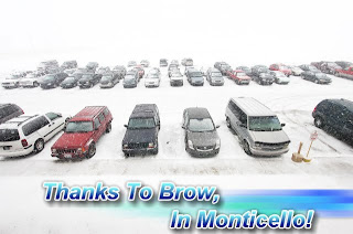 This picture was also taken in the Monticello, area around 1:pm this afternoon. A big thank you to Brow, for sending in some I Witness pics and video of the snow in our local area! Keep up the Awesome Work! :) If any of my bloggers would like to send in weather Pictures, Video, or Weather Reports, you can send them to me at dobby1717@aol.com Thanks Ahead Of Time!
Another Snow band moved into the area in the evening hours. You can see the snow starting to cover the viewing area in this radar image below. It was taken at 5:31pm EST. The darker blues are the heavier snow bands. You can see much of the WLFI viewing area covered in the snow at 5:31pm EST. Here a picture I took at 5:30pm EST in Lafayette below.
 Lots of dime sized snowflakes falling across the area. You can even see the icicles formed along the roof. Ahhhhhhh I love winter lol. This will pretty much be the story as we continue into the overnight hours! Some scattered show showers across the viewing area giving way to an inch or less of snowfall. However the more north you go in the viewing area the slightly higher the amounts will be from our southern counties.
Here's a video I also took in the Lafayette, area around 5:30pm EST this evening.
Again this is pretty much what it will look like as the evening continues. Here's look at your quick cast below.
Quick Cast.....
Tonight expect a low around 19* degrees with winds between 4 and 7 mph. Also light scattered snow showers across the area. Snowfall around an inch or less. Expect slightly higher amounts the more north you go.
Friday we will look for partly to mostly cloudy skies across the area. Clouds will be on the increase as the day continues. I also still have around a 20% chance for a few scattered light snow flurries across the area later on that night into early Saturday. Expect a high around 31* degrees with a low Friday night around 27* degrees. Winds between 5 and 8 mph.
Saturday we will look for a few light scattered snow flurries in the early morning. A few breaks in the clouds will be possible in the afternoon however overall we will be mostly cloudy. More clouds move into the area that evening / night. Highs will be around 36* degrees with lows that night around 22* degrees. Wind light between 3 and 5 mph.~~~~~~~~~~~~~~~~~~~~~~~~~~~~~~~~
~~~~~~~~~~~~~~~~~~~~~~~~~~~~~~~~~~
Well that just about says it all bloggers! Please be careful when heading out in the morning as there could be a little snow on the roads! Thank you all for reading! And thanks for the pictures! I wish you all an awesome Friday, And Weekend! I'll check back again soon.....
God Bless!
Big Post On The Way!
I have a BIG post coming your way tonight bloggers! Be sure to check back. You don't wanna miss it!
DEVELOPING.....
DEVELOPING.....
Wednesday, January 26, 2011
Temperatures Right Around Average. Light Snow Also On The Way!
Well, today we hit a high in Lafayette, of 32* degrees. Average high for this time of year is right around 33* degrees. We were only one degree short of that number which isn't bad at all. So what do we have in store over the next day or two? Well, I believe we will continue with temperatures in the low 30s right around average between Thursday and Friday. However a little snow is also in the forecast. Take a look.
Above is a map I put together to show you all what we are expecting weather - wise Thursday. You can see highs will be right around average with some scattered light snow showers across the viewing area. No it's not looking like a whole lot this time around as this is a clipper system coming from our northeast.
So just how much could we be looking for?
Well, the MOS models are not showing a whole lot. Not even picking up a trace at this time! The Bufket weather models are expecting to see snowfall right around 0.12" Inches as a grand total. However the GFS models say something a little different. Calling for snowfall around an inch with slightly higher amounts in northern Indiana and in the northern counties of the viewing area. So after looking through this data what's my thinking?
Take a look.
Right now I'm looking for snowfall over much of the viewing area to be around an inch or less. Give or take a few tenths of an inch. However I do expect higher amounts in extreme northern Indiana with slightly higher amounts the more north you head in the viewing area. However overall nothing major. Just some minor snow accumulation. Still even if it's only a dusting we will need to take it slow on the roads. Something as light and minor as a dusting can be very slick to drive in.
Here's your quick cast below.
Quick Cast.....
Thursday we will look for increasing clouds with some scattered light :Pm snow showers likely across the area. Minor snowfall totals expected. (See above map). I'm looking for highs to be right around average which is 33* degrees, With lows that night near average around 19* degrees. Average low for this time of year is around 17* degrees. Winds will be between 5 and 10 mph.
Friday we will look for mostly cloudy skies overall. However a few breaks in the clouds may be possible in the afternoon hours. Also I can't rule out around a 20% chance for a few light scattered show flurries across the area Friday night into early Saturday. Highs will be around 31* degrees with lows Friday night right around 26* degrees. Winds will be between 7 and 10 mph.
~~~~~~~~~~~~~~~~~~~~~~~~~~~~~~~~~~~
~~~~~~~~~~~~~~~~~~~~~~~~~~~~~~~~~~~~~
That's it for now bloggers. I will check back tomorrow afternoon if needed. You can always send me your weather pictures and weather reports to dobby1717@aol.com Also go ahead and head over to the top right of the blog and tell me who you think will win the Superbowl! ;)
Thanks for reading. God Bless!
Tuesday, January 25, 2011
Keep The Comments Coming! No One Needs To Apologize!
Hey everyone! I just wanted to say that this blog is something I do as a hobby. I work otherwise, and I enjoy doing the weather blog for everyone! I enjoy bringing you all my thoughts on the weather and I'm very glad you take the time out of your day to read what I have to say. Thank You! And this is a Blog! So yes, please feel free to post whatever you want as long as it's clean! Positive comments toward me, Or Negative comments toward me! Whatever you want. I don't take anyone of it to hart. It's all for fun! This is a fun blog and none of my bloggers need to apologize for anything! So please continue to comment and have fun. This is the most comments my blog has seen in awhile anyway lol :)
Now lets get to the weather! Take a look at this bloggers. While we have seen nothing but cloudy skies across the area the past week, other places have seen a beautiful show in the clear night sky!
NORRSKEN: "I stepped outside to walk my old black lab tonight, Jan. 24th, when I heard a friend yell norrsken! (Swedish for aurora)," reports Chad Blakley of Abisko National Park, Sweden. "I ran inside to grab my camera, but I needn't have hurried because the lights danced and played for more than two hours." He took this picture using his Nikon D7000: "It was another great night of Northern Lights here in Abisko!" adds Blakley. "I guess I owe these shots to my dog."
That's right. For the rest of this month it's looking like the only snow we would see will be in Clipper form! (Alberta Clipper Systems) So nothing BIG! However I'm still watching the weather pattern over the first week of February as models at this time show some precipitation moving into the area. And I will continue to keep everyone posted on this as we continue to move closer.
Here's your Wednesday - Thursday quick cast below.
Quick Cast.....
Wednesday we are looking for Partly cloudy skies across the viewing area through out the day. Highs will be around 30* degrees with lows that night around 14* degrees. Winds will be light between 5 and 8 mph.
Our high temperatures will range between the upper 20s and low 30s from now through Sunday. And as for our lows, They will range between the upper teens and low 20s between Thursday night and Saturday night. It's looking like we will see another COOL DOWN by the start of next week!
Thursday we will look for mostly cloudy skies in the morning however a few :PM snow showers are looking likely! Only minor snow accumulation is expected at this time. Expect highs around 28* degrees with lows Thursday night around 24* degrees. Winds will be light between 5 and 10 mph.
~~~~~~~~~~~~~~~~~~~~~~~~~~~~~~~~~~~~~~
~~~~~~~~~~~~~~~~~~~~~~~~~~~~~~~~~~~~~~~~
That's the latest for now bloggers. Stay safe and God Bless! Remember you can always send me your weather pictures and reports to Dobby1717@aol.com
I enjoy reading what you all have to say so lets get some Comments going! ;)
Feel free to talk it up! :)
Now lets get to the weather! Take a look at this bloggers. While we have seen nothing but cloudy skies across the area the past week, other places have seen a beautiful show in the clear night sky!
NORRSKEN: "I stepped outside to walk my old black lab tonight, Jan. 24th, when I heard a friend yell norrsken! (Swedish for aurora)," reports Chad Blakley of Abisko National Park, Sweden. "I ran inside to grab my camera, but I needn't have hurried because the lights danced and played for more than two hours." He took this picture using his Nikon D7000:
"It was another great night of Northern Lights here in Abisko!" adds Blakley. "I guess I owe these shots to my dog."The sun helped a little, too. The display was caused by an episode of "south-pointing Bz." The interplanetary magnetic field near Earth tipped south, opening a hole in Earth's magnetosphere; solar wind poured in to fuel the display. High-latitude sky watchers should remain alert as Bz continues to favor polar auroras on Jan. 25th.
~~~~~~~~~~~~~~~~~~~~~~~~~~~~~~~~~~
~~~~~~~~~~~~~~~~~~~~~~~~~~~~~~~~~~~~~
If there is one thing that I would love to see in person someday it would have to be the Northern Lights! I have seen so many amazing pictures and could only imagine what it would be like to look up and see them for myself! WOW!
Well, we may not have any northern lights in the forecast here in Indiana bloggers. However what about some sun?? Or will we remain in the clouds? Well, right now I'm looking for Partly cloudy skies through out the viewing area tomorrow! So a few peaks of sun are in the forecast. Now a lot of you have been asking about snow! And when more could be on the way. Well I put together this map below.
That's right. For the rest of this month it's looking like the only snow we would see will be in Clipper form! (Alberta Clipper Systems) So nothing BIG! However I'm still watching the weather pattern over the first week of February as models at this time show some precipitation moving into the area. And I will continue to keep everyone posted on this as we continue to move closer.
Here's your Wednesday - Thursday quick cast below.
Quick Cast.....
Wednesday we are looking for Partly cloudy skies across the viewing area through out the day. Highs will be around 30* degrees with lows that night around 14* degrees. Winds will be light between 5 and 8 mph.
Our high temperatures will range between the upper 20s and low 30s from now through Sunday. And as for our lows, They will range between the upper teens and low 20s between Thursday night and Saturday night. It's looking like we will see another COOL DOWN by the start of next week!
Thursday we will look for mostly cloudy skies in the morning however a few :PM snow showers are looking likely! Only minor snow accumulation is expected at this time. Expect highs around 28* degrees with lows Thursday night around 24* degrees. Winds will be light between 5 and 10 mph.
~~~~~~~~~~~~~~~~~~~~~~~~~~~~~~~~~~~~~~
~~~~~~~~~~~~~~~~~~~~~~~~~~~~~~~~~~~~~~~~
That's the latest for now bloggers. Stay safe and God Bless! Remember you can always send me your weather pictures and reports to Dobby1717@aol.com
I enjoy reading what you all have to say so lets get some Comments going! ;)
Feel free to talk it up! :)
Developing. Tonight's Post.
Tonight's post will have some details on the temperatures for the rest of this week along with a look at when the next snow chance could be.
DEVELOPING.....
DEVELOPING.....
Monday, January 24, 2011
How Much Snow Has Lafayette, Seen This January?
Hey bloggers. First off I wanted to start by apologizing. I didn't mean to offend anyone in my last blog post. I wasn't trying to downgrade any meteorologist by saying my forecast was any better then anyone else! That wasn't my intention at all! I know how hard meteorology is! And I would never say that I was better then anyone else. I was proud and figured that it was good news for JIWB that we was among some of the few to call for a high amount of 2" inches. Whether that be a range of a trace to 2" inches which is what my MOS models showed. Or a 1" to 2" inch range. I just got a little excited I guess. However that won't happen again! I will continue post my forecast and just let you all be the judge. Again I Apologize!
 It's seems that we have had snow on the ground just about everyday all winter long doesn't it?
As you can see above it's been a winter filled with white fluffy snow and lots of dog tracks in the backyard if your like myself. But just how much snow have we seen so far this month? Take a look.
That's right the January snowfall average is right around 5.4" Inches. However we are running a good 3" inches above our average for this time of year! Lafayette, coming in with a current January snowfall total of 8.4" Inches. With still more winter on the way!
One thing that we need to start doing when it comes to winter weather is (Driving Safe). After the snow fell earlier this morning I came across many reports of over a dozen slide - offs on the road ways! We have gotta start taking our time while out on snow covered slick roads! More than a dozen slide-offs on I-65
Indiana State Police: roads are slick from snow
 It's seems that we have had snow on the ground just about everyday all winter long doesn't it?
As you can see above it's been a winter filled with white fluffy snow and lots of dog tracks in the backyard if your like myself. But just how much snow have we seen so far this month? Take a look.
That's right the January snowfall average is right around 5.4" Inches. However we are running a good 3" inches above our average for this time of year! Lafayette, coming in with a current January snowfall total of 8.4" Inches. With still more winter on the way!
One thing that we need to start doing when it comes to winter weather is (Driving Safe). After the snow fell earlier this morning I came across many reports of over a dozen slide - offs on the road ways! We have gotta start taking our time while out on snow covered slick roads!
More than a dozen slide-offs on I-65Indiana State Police: roads are slick from snow
TIPPECANOE COUNTY, Ind. All the snow during the morning commute has caused several slide-offs around Tippecanoe County. Indiana State Police reported more than a dozen slide-offs on Interstate 65 between mile marker 194 and State Road 26 during the morning commute.
Police urged drivers to slow down on the roads.
~~~~~~~~~~~~~~~~~~~~~~~~~~~~~
~~~~~~~~~~~~~~~~~~~~~~~~~~~~~~~~
Here's a look at your quick cast below.
Quick Cast.....
Tuesday we will look for mostly cloudy skies across the area. A few breaks in the clouds are possible. Expect highs around 31* degrees which will feel like a heat wave after highs only in the low teens over last weekend! Lows will be around 18* degrees. Winds light between 3 and 5 mph.
Wednesday we will look for partly cloudy skies across the viewing area. Highs slightly cooler around 29* degrees with lows Wednesday night around 14* degrees. Winds will again be light between 3 and 5 mph.
I'll check back again soon.
Take Care.....
JIWB, One Of The Few To Be On Top Of This Small System!
Morning bloggers. Well, a lot of other stations and meteorologist was calling for only minor accumulations snow - wise last night into the early morning hours! However here at JIWB we have been on top of this system from the start! One of the only places calling for a trace to two inches of snowfall. And guess what?? We called it right! Just about everyone in the viewing area reporting between 1" and 2" inches of snow! This is great news for JIWB! Just take a look at these snowfall totals below.
Frankfort, 2.0" Inches.
West - Lafayette, 1.5" Inches.
Remington, 1.2" Inches.
Lafayette, 1.0" Inches.
Kokomo, 1.0" Inches.
Attica, 1.0" Inches.
Logansport, 0.8" Inches.
~~~~~~~~~~~~~~~~~~~~~~~~~~~~~
~~~~~~~~~~~~~~~~~~~~~~~~~~~~~~~~~~~~~
You can see just about everyone coming in with nothing less then 1" inch. The only report under an inch that I received was from Logansport, as seen above. And even Logansport, was pushing that inch mark.
So lets keep up the good work here at JIWB and continue to be the place to go for all your weather details! Have an Awesome day bloggers. I'll check back with another update later on tonight.
God Bless!
Sunday, January 23, 2011
Snow Showers Tonight Into Tomorrow!
Snow showers are out to our west at this time. Moving closer and closer as I type to you! So I believe it is safe to say that scattered snow showers are in the forecast for tonight! ;) Which I'm sure you already knew lol. Take a look at tonight's weather outlook below.
You can see I'm expecting a few scattered snow showers to take place tonight. Right now looking for the snow between 9:pm and 10:pm EST. We will look for a low around 12* degrees with winds between 5 and 10 mph. This means a night time wind chill of 7* to -7* degrees! So dress warm if your heading out cause it's gonna be cold!
You can see the snow just to our west in the radar image below. Soon this will be entering the WLFI viewing area.
Radar Image Taken At 6:24pm EST.....
I have many snowfall reports from the south western area of IL, of snowfall between 0.8" inches and 2" Inches. This is why I believe that between tonight and tomorrow we could see anywhere between a trace and 2" inches area wide. However I believe that most areas will be less then an inch!
Here's tonight through Monday's outlook below.
Quick Cast.....
Monday we will look for a few snow showers across the viewing area. Clouds will try to break in the afternoon hours however overall we will be mostly cloudy. Highs will be in the low to middle 30s with lows Monday night around 20* degrees. Wind between 10 and 15 mph which means we can expect a night time wind chill around 6* degrees.
Tuesday we will look for partly cloudy skies across the viewing area. We can expect highs around 31* degrees with a low Tuesday night around 16* degrees. Winds will be light between 3 and 5 mph.
~~~~~~~~~~~~~~~~~~~~~~~~~~~~~~~~~~~~~
~~~~~~~~~~~~~~~~~~~~~~~~~~~~~~~~~~~~~~~~
~~~~~~~~~~~~~~~~~~~~~~~~~~~~~~~~~~~~~~~~
So that's the weather story for the viewing area tonight bloggers. Also it looks like the Green Bay Packers are going to the Superbowl. Who do you think will be the winner of the PIT, VS NYJ, game??
Tonight is a cold winters night that is perfect for football! ;) Take care bloggers.
I'll check back soon.
Snow To Our West
We have snow showers on radar to our west. This will move into the area later on tonight around 9:pm or 10:pm EST. Currently looking or snowfall between a Trace and maybe 2" inches possible at this time.
I'm keeping watch on the NFC and AFC championship games while going through more weather data for tonight blog post.
Be sure to check back!
I'm keeping watch on the NFC and AFC championship games while going through more weather data for tonight blog post.
Be sure to check back!
Friday, January 21, 2011
A Lot Of Cold Weather In Your Forecast!
Last night was one of the coldest nights we have seen this winter! WOW! But how long is this cold cold weather going to continue? I will have your answer in just a minute. First I wanted to take a second to show you all some data out of Indianapolis that has to do with last nights lows! Take a look at this.
Low temperature this morning in Indianapolis: -3 (at 0846 EST)
Last time it was this cold in Indianapolis: February 5, 2009
Last time it was colder in Indianapolis: January 16, 2009 (-12)
Record low temperature for today in Indianapolis: -21 (1984)
This is the coldest it has been in Indianapolis in two years! WOW! See, I wasn't joking when I said we have a lot of cold weather to talk about lol. Take a look at last night's
temperatures in Lafayette below. This is what I recorded here at JIWB. You can see a low last night of -0.2* Degrees! With a low wind chill of -11* degrees! The record low on this very day was set back in 1994 and it was -15* degrees! take note that this is without wind chill when that record low was recorded. That's just amazing! You can also see in that image above that some of the roads are still snow covered. Most main roads are looking pretty good at this time. With just some patchy snow in areas. Still take your time while out!
 You can see Lil Bit, the chihuahua doing her best to stay warm earlier this afternoon. Making sure to stay under the blankets and up off the flood! She is reminding us all to remember our pets during this cold winter time! Make sure they have a warm place to stay. If your pets our outdoors you may want to think about bringing them in for a while! They get cold too.
So just how long is this cold weather going to continue? Well, we have another cold front that will drop lows into the single digits once again tomorrow night. This front will pass through the area later on tomorrow afternoon / evening which will allow for lows tomorrow night to fall into the single digits again! Which means wind chills tomorrow night around -10* degrees. It was so cold earlier this afternoon that your nose froze up! lol. Brow, knows what I'm talking about ;) That's one thing he will never live down! lol :) I did walk out earlier this morning and took a breath, The air was / is SOOO dry with dew points around 0* to -4* degrees that I started to cough. Now that's dry!
Right now I think we will keep the lows in the single digits and teens from tonight through Tuesday where we may see lows warm up into the low 20s before dropping back into the teens again Wednesday through next week.
Here's a look at your detailed weekend quick cast below.
Weekend Quick Cast.....
Saturday we will look for mostly cloudy skies across the area with a few scattered light snow showers off and on. Currently not looking for much in the way of snow accumulation at this time. Expect snowfall less then a half inch. Models are showing me an exact snowfall number of 0.04" Inches. Look for highs around 24* degrees with lows Saturday night for the Purdue basketball game around 4* degrees! Dress warm if your heading out! Winds will be between 10 and 15 mph which means we will see a daytime wind chill around 15* to 13* degrees with a night time wind chill around -10* degrees!
Sunday we will see partly cloudy to mostly cloudy skies through out the area. More clouds will try and move in that night into Monday. A few snow flurries / snow showers will be possible into Monday as well. Highs Sunday will be around 20* degrees with lows around 11* degrees. Winds light between 3 and 5 mph.
~~~~~~~~~~~~~~~~~~~~~~~~~~~~~~~
~~~~~~~~~~~~~~~~~~~~~~~~~~~~~~~~~~
You can see a low last night of -0.2* Degrees! With a low wind chill of -11* degrees! The record low on this very day was set back in 1994 and it was -15* degrees! take note that this is without wind chill when that record low was recorded. That's just amazing! You can also see in that image above that some of the roads are still snow covered. Most main roads are looking pretty good at this time. With just some patchy snow in areas. Still take your time while out!You can see Lil Bit, the chihuahua doing her best to stay warm earlier this afternoon. Making sure to stay under the blankets and up off the flood! She is reminding us all to remember our pets during this cold winter time! Make sure they have a warm place to stay. If your pets our outdoors you may want to think about bringing them in for a while! They get cold too.So just how long is this cold weather going to continue? Well, we have another cold front that will drop lows into the single digits once again tomorrow night.
This front will pass through the area later on tomorrow afternoon / evening which will allow for lows tomorrow night to fall into the single digits again! Which means wind chills tomorrow night around -10* degrees. It was so cold earlier this afternoon that your nose froze up! lol. Brow, knows what I'm talking about ;) That's one thing he will never live down! lol :) I did walk out earlier this morning and took a breath, The air was / is SOOO dry with dew points around 0* to -4* degrees that I started to cough. Now that's dry!Right now I think we will keep the lows in the single digits and teens from tonight through Tuesday where we may see lows warm up into the low 20s before dropping back into the teens again Wednesday through next week.
Here's a look at your detailed weekend quick cast below.
Weekend Quick Cast.....
Saturday we will look for mostly cloudy skies across the area with a few scattered light snow showers off and on. Currently not looking for much in the way of snow accumulation at this time. Expect snowfall less then a half inch. Models are showing me an exact snowfall number of 0.04" Inches. Look for highs around 24* degrees with lows Saturday night for the Purdue basketball game around 4* degrees! Dress warm if your heading out! Winds will be between 10 and 15 mph which means we will see a daytime wind chill around 15* to 13* degrees with a night time wind chill around -10* degrees!
Sunday we will see partly cloudy to mostly cloudy skies through out the area. More clouds will try and move in that night into Monday. A few snow flurries / snow showers will be possible into Monday as well. Highs Sunday will be around 20* degrees with lows around 11* degrees. Winds light between 3 and 5 mph.
~~~~~~~~~~~~~~~~~~~~~~~~~~~~~~~
~~~~~~~~~~~~~~~~~~~~~~~~~~~~~~~~~~
As for tonight? Expect cloudy skies with lows around 5* degrees! So bundle up bloggers! It's gonna be COLD!
Have an AWESOME weekend!!
I'll check back soon.
You can always send me your weather pics and weather reports at: dobby1717@aol.com
God Bless.Hot Cocoa Advisory!!
That's right a Hot Cocoa Advisory is in effect do to this Trough of cold air we're in!
So much COLD weather to talk about in the forecast tonight. Also a look back at how cold it's been last night and today! Brrrrrrrrr Keep out the heavy coats and extra blankets! Your gonna need them over the next week!
Check back for a new update later tonight!
So much COLD weather to talk about in the forecast tonight. Also a look back at how cold it's been last night and today! Brrrrrrrrr Keep out the heavy coats and extra blankets! Your gonna need them over the next week!
Check back for a new update later tonight!
Thursday, January 20, 2011
Old Man Winter Keeps Us COLD, Snowy, And SLICK!
Final Snowfall Totals From Across The Area.
Jamestown, Boon, County, 3.1" Inches.
Kokomo, 2.0" Inches.
West - Lafayette, 1.9" Inches.
Lafayette, 1.8" Inches.
Attica, 1.5" Inches.
Otterbein, 1.3" Inches.
Logansport, 1.0" Inches.
Remington, 0.8" Inches.
~~~~~~~~~~~~~~~~~~~~~~~~~~~~~~~~
~~~~~~~~~~~~~~~~~~~~~~~~~~~~~~~~~~~
Old man winter is just getting started here in the Midwest! We have more cold weather in the forecast now that this snow system has pushed off to our east. Roads this afternoon have been snow covered and slush covered. I did get out for a few while working on clearing walks, and driveways. Here are a few pictures I snapped below. You can see that Beck Lane was totally snow and slush covered. Also 9th street covered in the slick snow. However the main roads are not the only thing that causes a problem while most of us are out and about in this kind of weather! That's right the Parking lots are one of the most slick paved areas there is! Completely covered in slick slush and snow! Take a look.
 The thing that is sooo bad with the roads still having this much slush on them right now is, Freezing! Yes, with lows tonight dropping to -4* degrees without wind chill everything that was melted today will re - freeze tonight and become solid ice by the time many head out in the morning! This could get dangerous fast.
 You can see tonight's outlook in the map above! And I'm not joking about the wind chills you see posted above either. Your eyes are not playing tricks on you. That really says -15* to -20* below zero wind chill! As I have said earlier this afternoon this means you can get frostbite in 30 Minutes or less on any part of your body that's not covered! Hats and gloves are a MUST Tonight / Tomorrow through out this week!
As for how much snow has been reported across the area and blowing and drifting threat's tonight! Well, here's a look at a few reports from around the area below. These are not final snowfall amounts! I will have the final snowfall amounts posted tomorrow! This is just a few reports as of 4:30pm EST and 5:00pm EST earlier this evening. This way you kinda have an idea as to what will be blowing around tonight! You can see I have reports of a wide area ranging from 1" to 3" inches. And this snow is a Light Fluffy snow! Which means it won't take much wind to blow it around like crazy. We will see winds tonight between 10 and 15 mph with a few gusts to 20 mph at times. The time range for these winds will be between now and 4:am EST Friday. If you are going to be out in this time frame please be careful! Visibility may be reduced and the roads will be freezing overnight! "Black Ice Alert"
 Also we have that Wind Chill Advisory in effect for the northern half of the viewing area. This advisory is in effect from 1:am EST tonight until Noon EST Friday. Here are the following counties currently in this advisory below.
White, Cass, Benton, Newton, Jasper, counties.
~~~~~~~~~~~~~~~~~~~~~~~~~~~~~~~~~~
~~~~~~~~~~~~~~~~~~~~~~~~~~~~~~~~~~~~~
So what's causing these cold temperatures? Well, if you look at the map above you can see that big Trough of cold air we are sitting in! All that COLD polar air is being sent down to us from our neighbors to the north! Yes, Canada! They're nice people up there and want to share the cold! :) This Trough is the reason we will be forecasting nightly lows over the next 5 five days in the single digits and teens! Highs just barely reaching the low 20s this weekend into next week.
Take a look at your Friday - Saturday Quick Cast below for more details.
Quick Cast.
Friday we will be tracking COLD polar air with highs not getting out of the single digits! We will look for partly cloudy skies in the morning hours with skies becoming mostly cloudy as the day continues into the afternoon hours. A few scattered snow flurries will be possible late Friday night after 2:am EST into Saturday. Expect a high of 7* degrees with a low that night of 5* degrees. Wind chills during the daytime hours after the gusty morning winds end by 4:am EST will be around 0* to -7* degrees.
Saturday we will be tracking a few more scattered light snow showers across the area through out much of the day. Currently not looking for much. Snowfall at this time around an inch or less. Expect highs around 21* degrees with lows Saturday night around 4* degrees! Winds between 10 and 15 mph. This will make for a daytime wind chill of around 10* to 6* degrees. And a night time wind chill around -5* to -10* degrees.
~~~~~~~~~~~~~~~~~~~~~~~~~~
~~~~~~~~~~~~~~~~~~~~~~~~~~~~~~~
So that's just about it for now bloggers! Please be safe tomorrow! It will be one of the coldest days so far! With Dangerous wind chills in the morning hours! Really even into the daytime hours as well. And the roads will be ICE!
Stay Safe and God Bless!
I'll leave you with a look at your 5 - Day Forecast!
Jamestown, Boon, County, 3.1" Inches.
Kokomo, 2.0" Inches.
West - Lafayette, 1.9" Inches.
Lafayette, 1.8" Inches.
Attica, 1.5" Inches.
Otterbein, 1.3" Inches.
Logansport, 1.0" Inches.
Remington, 0.8" Inches.
~~~~~~~~~~~~~~~~~~~~~~~~~~~~~~~~
~~~~~~~~~~~~~~~~~~~~~~~~~~~~~~~~~~~
Old man winter is just getting started here in the Midwest! We have more cold weather in the forecast now that this snow system has pushed off to our east. Roads this afternoon have been snow covered and slush covered. I did get out for a few while working on clearing walks, and driveways. Here are a few pictures I snapped below.
You can see that Beck Lane was totally snow and slush covered. Also 9th street covered in the slick snow. However the main roads are not the only thing that causes a problem while most of us are out and about in this kind of weather! That's right the Parking lots are one of the most slick paved areas there is! Completely covered in slick slush and snow! Take a look.The thing that is sooo bad with the roads still having this much slush on them right now is, Freezing! Yes, with lows tonight dropping to -4* degrees without wind chill everything that was melted today will re - freeze tonight and become solid ice by the time many head out in the morning! This could get dangerous fast.You can see tonight's outlook in the map above! And I'm not joking about the wind chills you see posted above either. Your eyes are not playing tricks on you. That really says -15* to -20* below zero wind chill! As I have said earlier this afternoon this means you can get frostbite in 30 Minutes or less on any part of your body that's not covered! Hats and gloves are a MUST Tonight / Tomorrow through out this week!As for how much snow has been reported across the area and blowing and drifting threat's tonight! Well, here's a look at a few reports from around the area below. These are not final snowfall amounts! I will have the final snowfall amounts posted tomorrow! This is just a few reports as of 4:30pm EST and 5:00pm EST earlier this evening. This way you kinda have an idea as to what will be blowing around tonight!
You can see I have reports of a wide area ranging from 1" to 3" inches. And this snow is a Light Fluffy snow! Which means it won't take much wind to blow it around like crazy. We will see winds tonight between 10 and 15 mph with a few gusts to 20 mph at times. The time range for these winds will be between now and 4:am EST Friday. If you are going to be out in this time frame please be careful! Visibility may be reduced and the roads will be freezing overnight! "Black Ice Alert"Also we have that Wind Chill Advisory in effect for the northern half of the viewing area. This advisory is in effect from 1:am EST tonight until Noon EST Friday. Here are the following counties currently in this advisory below.White, Cass, Benton, Newton, Jasper, counties.
~~~~~~~~~~~~~~~~~~~~~~~~~~~~~~~~~~
~~~~~~~~~~~~~~~~~~~~~~~~~~~~~~~~~~~~~
So what's causing these cold temperatures?
Well, if you look at the map above you can see that big Trough of cold air we are sitting in! All that COLD polar air is being sent down to us from our neighbors to the north! Yes, Canada! They're nice people up there and want to share the cold! :) This Trough is the reason we will be forecasting nightly lows over the next 5 five days in the single digits and teens! Highs just barely reaching the low 20s this weekend into next week.Take a look at your Friday - Saturday Quick Cast below for more details.
Quick Cast.
Friday we will be tracking COLD polar air with highs not getting out of the single digits! We will look for partly cloudy skies in the morning hours with skies becoming mostly cloudy as the day continues into the afternoon hours. A few scattered snow flurries will be possible late Friday night after 2:am EST into Saturday. Expect a high of 7* degrees with a low that night of 5* degrees. Wind chills during the daytime hours after the gusty morning winds end by 4:am EST will be around 0* to -7* degrees.
Saturday we will be tracking a few more scattered light snow showers across the area through out much of the day. Currently not looking for much. Snowfall at this time around an inch or less. Expect highs around 21* degrees with lows Saturday night around 4* degrees! Winds between 10 and 15 mph. This will make for a daytime wind chill of around 10* to 6* degrees. And a night time wind chill around -5* to -10* degrees.
~~~~~~~~~~~~~~~~~~~~~~~~~~
~~~~~~~~~~~~~~~~~~~~~~~~~~~~~~~
So that's just about it for now bloggers! Please be safe tomorrow! It will be one of the coldest days so far! With Dangerous wind chills in the morning hours! Really even into the daytime hours as well. And the roads will be ICE!
Stay Safe and God Bless!
I'll leave you with a look at your 5 - Day Forecast!
A Brief Look At Tonight's Outlook.
 Above is a brief look at tonight's Cold winter night outlook. I will have all the details on this coming up very soon!
DEVELOPING.....
Snow And COLD!!!
Well, as the snow continues across parts of the WLFI viewing area this afternoon we will soon be tracking the COLD polar air that is going to move into the area this evening into the weekend! And let me tell you that it WILL BE COLD! Below Zero is possible tonight! Take a look at this below.
That's right the National Weather Service has a Wind Chill Advisory in effect for parts of the viewing area. Here are the following counties below.
White, Cass, counties from 11:pm EST this evening through out Noon EST Friday.
Benton, Newton, And Jasper, counties from 10:pm EST this evening through out Noon EST Friday.
~~~~~~~~~~~~~~~~~~~~~~~~~~~~~~~~~~~~
~~~~~~~~~~~~~~~~~~~~~~~~~~~~~~~~~~~~~~~
A WIND CHILL ADVISORY MEANS THAT VERY COLD AIR AND STRONG WINDS WILL COMBINE TO GENERATE LOW WIND CHILLS. THIS WILL RESULT IN FROST BITE AND LEAD TO HYPOTHERMIA IF PRECAUTIONS ARE NOT TAKEN. IF YOU MUST VENTURE OUTDOORS...MAKE SURE YOU WEAR A HAT AND GLOVES.
~~~~~~~~~~~~~~~~~~~~~~~~~~~~~~~~~~~~~~~
~~~~~~~~~~~~~~~~~~~~~~~~~~~~~~~~~~~~
I wouldn't be surprised to see this advisory extended through out the whole WLFI viewing area before tonight! This is why. Take a look at tonight's outlook. Yes, tonight I'm look for a few left over showers in the early evening hours before becoming mostly to partly cloudy for a little while during the overnight. Winds haven't been a problem through out the morning and afternoon hours however that will change as we head into this evening! I expect to see the winds start to pick up around 7:pm or so this evening. Winds will be between 10 and 15 mph gusting to 20 mph at times. The time frame for the highest winds will be between 7:pm EST this evening through possibly 6:am EST Friday morning.
Lows tonight will be between 0* and -4* degrees. With a wind chill anywhere between -15* and -20* degrees. This is why I wouldn't be surprised to see the wind chill advisory extended into the rest of the viewing area by tonight! With wind chills like this you could get frostbite in 30 minutes! So please be weather ready and dress as you should if you head out!
That's what we can look forward to tonight bloggers. Stay safe and warm! I'll check back as needed.
Also I'll be back tonight with your Friday - Saturday outlook!
Don't forget to send in your weather pictures, snowfall / rain reports, to JIWB.
Dobby1717@aol.com
That's right the National Weather Service has a Wind Chill Advisory in effect for parts of the viewing area. Here are the following counties below.
White, Cass, counties from 11:pm EST this evening through out Noon EST Friday.
Benton, Newton, And Jasper, counties from 10:pm EST this evening through out Noon EST Friday.
~~~~~~~~~~~~~~~~~~~~~~~~~~~~~~~~~~~~
~~~~~~~~~~~~~~~~~~~~~~~~~~~~~~~~~~~~~~~
A WIND CHILL ADVISORY MEANS THAT VERY COLD AIR AND STRONG WINDS WILL COMBINE TO GENERATE LOW WIND CHILLS. THIS WILL RESULT IN FROST BITE AND LEAD TO HYPOTHERMIA IF PRECAUTIONS ARE NOT TAKEN. IF YOU MUST VENTURE OUTDOORS...MAKE SURE YOU WEAR A HAT AND GLOVES.
~~~~~~~~~~~~~~~~~~~~~~~~~~~~~~~~~~~~~~~
~~~~~~~~~~~~~~~~~~~~~~~~~~~~~~~~~~~~
I wouldn't be surprised to see this advisory extended through out the whole WLFI viewing area before tonight! This is why. Take a look at tonight's outlook.
Yes, tonight I'm look for a few left over showers in the early evening hours before becoming mostly to partly cloudy for a little while during the overnight. Winds haven't been a problem through out the morning and afternoon hours however that will change as we head into this evening! I expect to see the winds start to pick up around 7:pm or so this evening. Winds will be between 10 and 15 mph gusting to 20 mph at times. The time frame for the highest winds will be between 7:pm EST this evening through possibly 6:am EST Friday morning.Lows tonight will be between 0* and -4* degrees. With a wind chill anywhere between -15* and -20* degrees. This is why I wouldn't be surprised to see the wind chill advisory extended into the rest of the viewing area by tonight! With wind chills like this you could get frostbite in 30 minutes! So please be weather ready and dress as you should if you head out!
That's what we can look forward to tonight bloggers. Stay safe and warm! I'll check back as needed.
Also I'll be back tonight with your Friday - Saturday outlook!
Don't forget to send in your weather pictures, snowfall / rain reports, to JIWB.
Dobby1717@aol.com
Roads Are SLICK And Snow Covered!
I was just out around Lafayette, and took some pictures. Roads are still pretty snow covered along with that SLICK slushy mess that is just such a pain to drive in. However from what I seen people are driving careful at this time which is good news. Here's just a taste of how snowy the roads are in the Lafayette, area.
I will have the rest of the pictures from around the area later on tonight along with a lot of talk about the COLD that is moving into the area after this snow!
Stay Tuned!
Stay Tuned!
.
Send in your pictures to JIWB at:
.
.
You can send me your Weather pictures, Weather reports such as Snowfall or Rainfall totals. Also send in your Weather stories about our current weather events if you like!
Snowfall To Expect.
Still expectingLess then an inch of snow in northern Jasper county and north of there. Expecting around an inch - 1.5" inches in Remington, and Monticello, areas. I'm still expecting around 2" inches in Lafayette, Frankfort, Otterbein, Kokomo, Romney, areas. With 2" to 3" inches in the Crawfordsville, Lebanon, and Russellville, areas. Also 3" - 5" inches in the Indianapolis area, and 4" to 6" inches in areas south of Indianapolis.
So still in our forecasted Snow - cast. Just on the lower side of the forecasted amounts! As in the 2" to 4" inch range we will see the lower side of that range which is around 2" inches.
So still in our forecasted Snow - cast. Just on the lower side of the forecasted amounts! As in the 2" to 4" inch range we will see the lower side of that range which is around 2" inches.
Subscribe to:
Posts (Atom)