I'M putting together a blog update with a look into the first week of October which will be posted here tomorrow. For now here is a quick cast blog cast below. We have some rain back in the forecast along with the chance at some scattered thundershowers by Friday! But hows the weekend?
Today. We will see some Partly cloudy to mostly clear skies over the WLFI viewing area. I look for highs to be in the low to middle 60s with lows falling into the middle 40s. The cool nights are upon us!
Thursday. Will be another day of Partly cloudy skies however I look for clouds to be on the increase by later on that evening / that night. We will also see some rain showers try to move in later on that night into Friday. We will look for highs to be slightly warmer around the middle to upper 60s. Lows will fall into the low 40s. Around 41* degrees.
Forecast Focus
Friday. Is when things will be watched closely as we will see another frontal system move into the area bringing a line of scattered rain / thundershowers possible. It is still to far away to call for any strong storms so at this time we will just continue to keep a close eye on things. And you know I will keep you posted! Temperatures this week into the weekend will range between middle 60s to low 70s. I don't see any big warm ups for a little while.
The weekend. Saturday I cannot rule out a few light light scattered showers possible. At this time it is around a 30% chance. I would not cancel any plans just yet! We see these forecast change all the time. So as we get closer I will have another look into your weekend forecast. Sunday is looking dry.
I will check back soon..........

Wednesday, September 30, 2009
Tuesday, September 29, 2009
Final Wind Numbers Are In! And Thanks For The Congrats! :)
 Well, here are the final numbers from all the windy weather we have seen around the area. You can see up around Gary, IN coming in with one of the highest gusts around 45 mph. Indianapolis, and Terre Haute, coming in not far behind with gusts to 43 mph. Lafayette, comes in with 37 mph and then finally Remington, with 32 mph. I know it sure was windy here in the Lafayette, area as all my Halloween decorations went flying all over the yard! lol. I put them back up tonight however by morning they will most likely be down once again.
.
.
Now in the morning hours as most of you will be heading out we will still see a few winds gusting to 20 - 25 mph however as the day continues we will see them slowly calm down to between 10 and 15 mph. That sounds much better don't you think? :)
.
.
I will be back later on with a bigger update! For now I need to give this computer a break and I need a little rest myself. (Tired). I will check back again real soon. I want to thank you all for all the congrats on the Indiana weather blog being in the J&C.
.
.
http://www.jconline.com/apps/pbcs.dll/article?AID=2009909280303
.
.
Remember this blog would be nothing without (YOU!) You all make this blog what it is! And I cannot thank you enough!
Monday, September 28, 2009
Cooler And Crisp Weather Is On The Way. How Cool? Read On To Find Out... Also Final Rainfall Totals...
 Above is a look at last nights radar. We were all keeping a close watch on things as the thunderstorms moved through the WLFI viewing area. Yes, we did have some severe thunderstorm watches issued for our area. Also some tornado watches issued for areas in IL, and even a few north west counties here in our viewing area. Though we had the severe thunderstorm watched issued, we only seen one cell move into the WLFI viewing area that had a severe thunderstorm warning with it. We had a lot of things working with us last night that kept the severe weather away!
.
.
IL, was looking at Lifted index of -5 which as some of you already know anything lower then -4 has a chance at becoming severe, Also they had the higher CAPE of 2,000 J/kg, They even had higher EHI which is used along with CAPE to figure out where severe weather would be likely to develop. Now Indiana on the other hand was looking at a much more stable air mass. We had Lifted index around 2.2, Also low CAPE values, and low EHI coming in at only 0.02. EHI usually needs to be around 1.0 to 2.0 to support thunderstorms / severe thunderstorm development. So as we seen the storms move into our area we was watching them slowly weaken. The only severe thunderstorm warning to be issued for the WLFI viewing area was in Western Benton, county. The rest of us really did not see severe weather. However scattered rain showers / thundershowers was reported in areas along with some lightning reported in Frankfort.
Rainfall Totals.....
.
.
Remington, 0.38" Inches.
.
.
Logansport, 0.28" Inches.
.
.
Lafayette, 0.23" Inches.
.
.
Kentland, 0.23" Inches.
.
.
Mellott, Trace.
~~~~~~~~~~~~~~~~~~~~~
~~~~~~~~~~~~~~~~~~~~~~~~~~~~~~~
.
.
So what caused all this to fire up? Well, it was that big cold front that is now making us feel pretty chilly out there! You can see in the image above what I'M talking about. This is how things will look today as that front continues to make its way through our area. We will see this front cool us off with highs only in the low 60s. Nights will cool off into the upper 40s! Yes, cool and crisp is the forecast today!
.
.
And looking into the weekly temperatures we can see we will be averaging our highs in the 60 to 70s. Yes, Autumn is here and coming faster then ever! Now I will check back a little later on with some wind gust totals from around the area! So be sure to check back.
.
.
Thank you all for reading... And thanks for all the Congrats!
Giving The All Clear!
Oak I'M giving the all clear for not only Cass, county but the whole WLFI viewing area. The storms have pushed off to our east.
Now we will be tracking the cold front which will not only bring the cooler temperatures but also the windy weather. We had a few gusts already earlier this afternoon near 30 mph however the real winds will be kicked up soon. As we see this cold front pass over our area we will see strong wind pushing behind it! Which means we can still look for gusts through out the night between 30 and 35 mph. Some areas near 40 mph will be possible!
Now I'M gong to put a quick little something together.
I will check back!
Sunday, September 27, 2009
Update As Of 12:55AM EDT...
Well, I think you all can go get some rest here soon! We are currently watching the last of these thunderstorms push off the the east of the viewing area. We had lots of watches posted for the area however not so much in the way of severe weather! Why? I will have that also coming up soon!
I will be back a little later on with all the final details. And also some rain totals and wind totals coming later on tomorrow!
I will be back once more to give the all clear. For now I can say that Tippecanoe, county is looking good! Benton, Newton, and Jasper, counties look good! Fountain, Montgomery, and white, counties look good! Warren, and Clinton, counties also look good!
And the last county, Cass, county will have the all clear within the next half hour!
I will be back! ;)
~~~~~~~~~~~~~~~~~~~~~~~
~~~~~~~~~~~~~~~~~~~~~~~~~~~
Things are still going as planed up to this point. Yes, there is a severe thunderstorm warning with that cell about to go through Benton, county. However these storms have weakened a LOT as they have moved into our stable air mass. And they are still weakening at this time. Areas of Benton, county still should be ready for lightning and some heavy rainfall.
Still tonight we will see scattered thundershowers through out parts of the WLFI viewing area.
I will check back again if needed.
 Oak I have gone through more data and here is the latest.
We are seeing some scattered thunderstorms firing up to our north and west at this time. Now the reason I'M not calling for severe thunderstorms for our area at this time is we have a more stable air mass over our area currently. We are seeing Lifted index around 2.1 which is good, We are also seeing Total Totals around 37 which is good, EHI is only at 0.02 which is also good. Still yes, this is a system to watch tonight just to be safe. I look for the worst to be in IL, and then to our north. Our northern counties will have to be watched! Benton, Newton, and Jasper, counties are currently under that Tornado watch until 3:00AM. And a Severe thunderstorm Watch also for White, county.
I will continue to watch this storm and I will keep you posted as needed.
Wind Advisory just issued for the WLFI Viewing Area. Lets All Be Ready And Try Not To Fly Away!
Update As Of 8:05pm EDT
Latest model data is showing gusts tonight to be between 30 and 35 mph. This would be much better then 45 near 50 mph that models where showing earlier this afternoon.
Also still the possibility for some scattered rain showers tonight as well in the WLFI viewing area. The more north you go the better the rain chance will be! I don't look for a squall line of strong storms to develop this time around.
I will check back if needed.
~~~~~~~~~~~~~~~~~~~~~~~
~~~~~~~~~~~~~~~~~~~~~~~~~
WIND ADVISORY IN EFFECT FOR THE FOLLOWING COUNTIES BELOW.....
CARROLL-WARREN-TIPPECANOE-CLINTON-HOWARD-FOUNTAIN-MONTGOMERY-
BOONE-TIPTON-HAMILTON-MADISON-DELAWARE-RANDOLPH-VERMILLION-PARKE-
PUTNAM-HENDRICKS-MARION-HANCOCK-HENRY-VIGO-CLAY-OWEN-MORGAN-
JOHNSON-SHELBY-RUSH-
INCLUDING THE CITIES OF...LAFAYETTE...FRANKFORT...KOKOMO...
CRAWFORDSVILLE...ANDERSON...MUNCIE...INDIANAPOLIS...TERRE HAUTE...
SHELBYVILLE
THIS WIND ADVISORY IS IN EFFECT FROM 8 AM TO 8 PM EDT MONDAY...
~~~~~~~~~~~~~~~~~~~~~~~~~~~
Yes as you can see above we already have that wind advisory in effect for the WLFI viewing area. Lafayette and around counties have already seen winds picking up as the day goes on. Lafayette is seeing gusts near 30 mph at this time. We will only see this get stronger as the day continues into the evening and over night hours. We are still looking for winds gusting to 35 to 40 mph some near 45 - 50 mph possible at times.
Remember to tie down anything that may be lose outside before things start to really kick up! Remember your wind driving safety tips as well if you happen to be out at this time.
Please keep your windy reports coming here on the indiana weather blog! You can also send pictures and reports to me at storm18mini@aol.com
Thanks again. I will check back as needed..........
"Windy" Is The Word Of The Day!
Hello Indiana weather lovers!
First off I had a comment last night that I would like to answer real quick before we move on.
Anonymous said...
That blob by passed Lafayette once again, not a drop of rain! Whats up with that! happens all the time even with snow!
~~~~~~~~~~~~~~~~~~~~~~~~~~~~~~~~~~~~~
Thank you for asking "Anonymous"! :)
As this "blob" was moving into the WLFI viewing area it was showing signs of dissipating. As it entered our more dry air, at this time it started to evaporate. As we seen this happen was when I said and I quote "It is looking like our southern counties will see the better chance at this moderate rainfall"
Which they are the ones that seen it. Areas of Fountain, and Montgomery County both seen this moderate rain pass through within that next half hour. This was not a cell that as it moved over Lafayette, then broke up and poof it was gone for no reason. This was a classic cell that was weakening as it moved into our more stable dry air. We was looking at Dew points around 50* to 54* degrees F. Which yes, is in the comfortable range however this would make our humidity around 31%. The closer the rain got the more it weakened and dissipated. Reason for Lafayette, not seeing any rain? Evaporation.
Hope this helps. If not let me know!
~~~~~~~~~~~~~~~~~~~~~~~~~~~~~
Now we got some wild weather to talk about today! I have partly cloudy skies back in the forecast however they are not coming for free! Yes, there's always a catch. :) If we want the partly cloudy skies then we have to take the windy weather that comes with it! And I'm not talking about light winds Oh NO. We are looking for high gusty winds near 50 mph possible by later on tonight into Monday.
 Do you still want the Partly cloudy skies? :) There are already some High wind advisories out to our north if not some already issued for our area then we can expect them here before long. You can really see the maps showing these high winds with how tightly packed the isobars are. We have already put out our Halloween decorations as did many others on my block. Lets just hope they know to tie them down so they don't blow away! Boy you can sure tell it is Autumn! lol. And if the wind is not enough we have a big cold front that will push through our area on Monday. This will cool us off into the low 60s as our high! Which means we will fall into the low 40s at night. Yes, the cool crisp nights are here. It will be nice to sit out watching the trees change color with a big cup of hot coffee or tea in hand.
 And take a look above. You can see I was telling the truth about leaves already falling in areas of Lafayette. This was at Armstrong park. I took this picture a few days ago when I was out jogging. I love to jog in the fall as there are so many beautiful things to enjoy. And I don't know why but it is always more fun to jog through the leaves. Ha Ha Call be crazy I don't care! :) There are just so many things I love about this season as well as Winter I could go on for hours. However we have not the time. ;-) Let me get to your quick cast blog cast below.
Today we will look for some Partly cloudy skies over the WLFI viewing area through out the day. We will see highs in the low 70s around 70* degrees and lows tonight will range in the low 50s around 53* degrees. Winds today will be between 10 and 20 mph however the winds tonight will be the BIG story as they will continue to get stronger slowly as the day continues. By tonight into Monday we will see winds between 25 and 30 mph with gusts to 40 - 45 mph as seen in the image at the top of this post. Be sure to tie anything lose down so it don't blow away. Currently I cannot rule out a 20% chance of a stray shower in the WLFI viewing area by later on tonight possible. Don't cancel any plans! Remember this is a 20% Chc, at this time.
.
.
Monday we will see more Partly cloudy skies through out much of the day. Highs will be cooler as the cold front passes over dropping our highs into the low to middle 60s around 65* degrees. Lows will be cold in the low 40s around 43* degrees. Something we are not use to just yet. Winds in the morning will still be a little breezy between 20 and 25 mph with a few gusts to 30 mph possible.
~~~~~~~~~~~~~~~~~~~~~~~~~~~~~~
.
.
I will be checking in later on today with another update! WINDY is the word of the day that is for sure. Also remember if your out driving later on this evening / tonight be sure to drive safe and take your time. As you already know winds like this can effect driving! Here is a little something below.
I will check back soon. Thanks for reading....................
.
.
WIND
Wind can be especially dangerous for trucks, recreational vehicles, campers, and vehicles towing trailers. Driving at slower speeds is the best defense.
When meeting large trucks and buses, be prepared to make steering corrections for sudden bursts of wind.
Wind generally reduces the driver's steering control. Tail winds push the car, which increases speed. Head winds slow the car down.
Crosswinds may cause the car to sway. Be prepared to make adjustments in speed and steering to compensate for wind conditions.
Saturday, September 26, 2009
Weather update at 5:30pm EDT.
 Just checking in real quick with a weather update. You can see in this radar image above taken at around 5:30pm EDT that we have some moderate rainfall moving into areas of the WLFI Viewing area here soon. Now there are a few severe thunderstorm watches out for areas south on Indianapolis which is where they have the better possibility at some strong storms. However for us I see nothing severe or in the way of strong storms. Just some moderate to heavy rain and times. This rain is moving in from the South west moving North North East. This system is currently moving at around 25 mph. It is looking like our southern counties will see the better chance at this moderate rainfall
That is the update! I will check back if needed. Remember you can always go to my Indiana weather page at http://justinsweatherpage.blogspot.com/ to see the lightning map as well as radars and satellites!
Developing Blog Update
I will check back real soon with your weekend weather outlook. Will it be dry? Will we see more misting rains? Will temperatures be in the 60s or 70s?
Also I have some nice fall pictures I took when jogging yesterday that I will be sure to post! We will also take a look into next week to see if we can keep those outdoor plans! ;-)
All this and more coming up later on tonight.
Thanks for checking in!
DEVELOPING Blog Update..........
Also I have some nice fall pictures I took when jogging yesterday that I will be sure to post! We will also take a look into next week to see if we can keep those outdoor plans! ;-)
All this and more coming up later on tonight.
Thanks for checking in!
DEVELOPING Blog Update..........
Friday, September 25, 2009
More Fog To Start The Day. A Stationary Front Keeps The Rain Chances!
 Yes, much like yesterday we will see another foggy start to our autumn day! I had many reports yesterday of all the Patchy foggy mess in Lafayette. And we got more early this morning. Just be smart and drive safe. With the past few days starting out foggy I wanted to post a few quick fog safety tips to help keep everyone safe! Take a look below.
Drive with lights on low beam. High beams will only be reflected back off the fog and actually impair visibility even more.
Reduce your speed -- and watch your speedometer. Fog creates a visual illusion of slow motion when you may actually be speeding.
Listen for traffic you cannot see. Open your window a little, to hear better.
Use wipers and defrosters as necessary for maximum visibility.
Use the right edge of the road or painted road markings as a guide.
Be patient. Do not pass lines of traffic.
Do not stop on a freeway or heavily traveled road. If your car stalls or becomes disabled, turn your vehicle's lights off, and take your foot off of the brake pedal. People tend to follow tail lights when driving in fog. Move away from the vehicle to avoid injury.
Lets all follow these tips when driving in fog (IF) we have to drive in fog so we all can be our safest!
Now after the fog lifts later on today we will be tracking some Mostly cloudy skies with a chance at more scattered light showers across the WLFI viewing area. Yesterday we seen around four tenths of an inch here in Lafayette, as expected. This will be pretty much what we will look for again today. Right now I think we will keep rainfall between 0.01" and 0.15" inches still under the quarter inch mark. Maybe a few locally higher amounts possible however not much. What is the reason for all this light scattered rain? Well, we can answer that with this image below. Here is our Prog chart for today. You can see we have a low pressure system kicking up some scattered showers across the area with a stationary front taking its time moving over our area. As most of you already know a stationary front is a very slow moving front. This is why we have had slight chances for rain the past few days and also today and for Saturday. Usually when we have stationary fronts in an area we see some kind of flood watch or warning issued. Well, that is just the case in areas of southern Indiana at this time. This is south on Indy where they have seen the heavier rainfall yesterday and last night. This Flash Flood Watch will be allowed to expire by 4:00AM This morning which is good news. We had a nice little rain in the WLFI viewing area yesterday however we still could use a little more. Not flooding however! ;-)
I will check back again soon bloggers. Stay dry and stay safe! Enjoy your day.....
Oh and Becky! I'll be sure to have your outdoor party forecast coming soon! ;-)
Thursday, September 24, 2009
Few Light Showers. Nothing Big Or Heavy!
Thick Fog over took the area early this morning across the area. Everyone needed to take there time and drive slow. If you headed out in the fog earlier I hope you all stayed safe!
 Light rain across the WLFI viewing area through out this morning into early afternoon possible. We can see the light scattered showers in both the radar image above and below. Below is a better view as it is my local radar and shows what hits the ground. Lafayette, has only seen around a tenth inch and this is what I look for most counties to end up with today. Not much over a tenth inch. Between 0.01" and 0.05" inches.
 Light rain across the WLFI viewing area through out this morning into early afternoon possible. We can see the light scattered showers in both the radar image above and below. Below is a better view as it is my local radar and shows what hits the ground. Lafayette, has only seen around a tenth inch and this is what I look for most counties to end up with today. Not much over a tenth inch. Between 0.01" and 0.05" inches.
I will check back again soon with a more detailed forecast and tomorrows outlook. Until then go ahead and have your umbrella ready however this looks more threatening on radar but it is not a washout! ;-)
Both radar images taken at 10:17am EDT.
When Will Cooler Temperatures Be Back In Our Area? Do We Have Rain In The Forecast? What About The First Frost? All This And More In Todays Blog Post!
Good morning bloggers. First off I just want to let you all know to be ready for some patchy fog if your heading out early this morning. (Patchy Fog Is Looking Possible At This Time Across The WLFI Viewing Area.)
Well, the sky is looking like fall with lots of overcast, The trees are also changing colors however the temperatures just won't work with us! All summer we have had below average temperatures give or take a few warm / hot days of upper 80s to 90s. Now that we want the cooler weather we are seeing temperatures around a good four to five degrees above average! COME ON WEATHER!! lol. So the question is "When will we get back on track and where we should be?" Well, I'M here with your answer. At least I'M here with what models are showing currently! Lets put it that way.
Our average high for this time of year should be in the middle 70s around 76* degrees. With average lows in the lower 50s around 52* degrees. What are we looking for today? Well we will look for highs in the upper 70s to low 80s possible. Right now we will keep it around 77* degrees. which is really pretty close to average. However I'M not ruling out a few more 80* degree days possible this week! Lows tonight however will be around ten degrees above average in the low 60s around 61* degrees.
Good news for all who love the cooler temperatures and fall as I know Becky, and I do, I see some temperatures closer to average back in the forecast off and on this week and then becoming a little more frequent as we start into next week. Yes, 70s are on the way! Just hang in there Bloggers. ;-)
As for when will we see more rain? Well, I have some models pointing to Friday however I'M not fully convinced just yet that we will see a good needed rain! Right now I am going to keep in a change. Around a 30% to 40% chance at this time. Because of how things went last rain we had where most in the WLFI viewing area picked up around five tenths of an inch, I want to wait until more models come in and become more clear. So I will be back again later on tonight with the latest! Do I see the possibility for strong to severe storms? "No not at this time."
First Frost?
 Yes, it is also that time of year when we all start wondering when will that first frost be? Well, I have a little something to give you all a range! Do any of you have gardens? If so then listen up! :) Check this out below.....
Low Temperature of 36 degrees or lower
(Patchy frost possible in outlying, low areas)
(Patchy Fog Is Looking Possible At This Time Across The WLFI Viewing Area.)Well, the sky is looking like fall with lots of overcast, The trees are also changing colors however the temperatures just won't work with us! All summer we have had below average temperatures give or take a few warm / hot days of upper 80s to 90s. Now that we want the cooler weather we are seeing temperatures around a good four to five degrees above average! COME ON WEATHER!! lol. So the question is "When will we get back on track and where we should be?" Well, I'M here with your answer. At least I'M here with what models are showing currently! Lets put it that way.
Our average high for this time of year should be in the middle 70s around 76* degrees. With average lows in the lower 50s around 52* degrees. What are we looking for today? Well we will look for highs in the upper 70s to low 80s possible. Right now we will keep it around 77* degrees. which is really pretty close to average. However I'M not ruling out a few more 80* degree days possible this week! Lows tonight however will be around ten degrees above average in the low 60s around 61* degrees.
Good news for all who love the cooler temperatures and fall as I know Becky, and I do, I see some temperatures closer to average back in the forecast off and on this week and then becoming a little more frequent as we start into next week. Yes, 70s are on the way! Just hang in there Bloggers. ;-)
As for when will we see more rain? Well, I have some models pointing to Friday however I'M not fully convinced just yet that we will see a good needed rain! Right now I am going to keep in a change. Around a 30% to 40% chance at this time. Because of how things went last rain we had where most in the WLFI viewing area picked up around five tenths of an inch, I want to wait until more models come in and become more clear. So I will be back again later on tonight with the latest! Do I see the possibility for strong to severe storms? "No not at this time."
First Frost?
Yes, it is also that time of year when we all start wondering when will that first frost be? Well, I have a little something to give you all a range! Do any of you have gardens? If so then listen up! :) Check this out below.....Low Temperature of 36 degrees or lower
(Patchy frost possible in outlying, low areas)
For the Farmland the normal frost date is around September 27th.
Lafayette, the normal frost date is around September 29th.
For Frankfort, usually around October 3rd.
~~~~~~~~~~~~~~~~~~~~~~~~~~~~~~~
Low Temperature of 32 degrees or lower
(Frost becomes widespread, with isolated pockets of hard freeze possible)
Farmland normal frost date is around October 6th.
Lafayette normal frost date is around October 9th.
Frankfort, normal frost date is around October 11th.
~~~~~~~~~~~~~~~~~~~~~~~~~~~~~~~~
Low Temperature of 28 degrees or lower
(Widespread Hard Freeze is Likely)
Farmland, normal frost date is around October 19th.
Lafayette, normal frost date is around October 21st.
Frankfort, normal frost date is around October 23rd.
~~~~~~~~~~~~~~~~~~~~~~~~~~~~~~~~~
So now we have an idea and we can have the gardens ready to go! I know my aunt will want to know about the frost as she has a wonderful garden every year. However this year it has been going wild!
And last but not least I wanted to show a little something that is another reminder of Autumn! Take a look below. Thank you all for reading. I will check back soon..........
AUTUMN LIGHTS: Northern autumn has begun, and that means it's aurora season around the poles. "Last night, the Northern Lights returned to our arctic skies," reports Claus Vogel of Baffin Island, Canada. "After a summer dominated by the midnight sun, it was good to see the autumn lights again."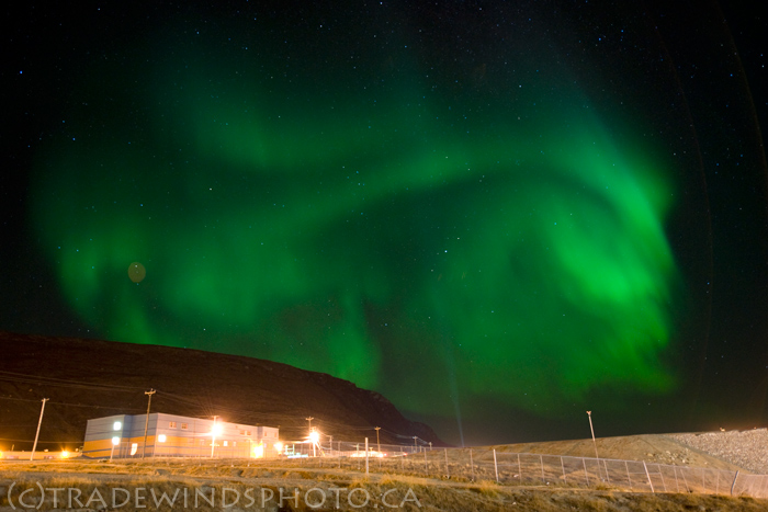 The display was sparked by a mild gust of solar wind. At this time of year, a mild gust is all it takes. During the weeks around equinoxes, the interplanetary magnetic field (IMF) near Earth tends to tilt south, an orientation that weakens our planet's magnetic defenses against the solar wind. The slightest gust can produce a lovely show.
"I'm looking forward to more dancing lights in the weeks ahead," says Vogel.
Wednesday, September 23, 2009
Developing Blog Update
Developing blog update on whats to come.
Preview.....
When will we see the cool temperatures come back to our great state?
Do we have anymore rain chances in the forecast this week? If so will it be more then a tenth inch?
How much longer will it feel like summer?
~~~~~~~~~~~~~~~~~~~~~~~~~~~
All this and more coming soon..........
DEVELOPING........................
Tuesday, September 22, 2009
"Happy Autumn"
Most of the heavy rainfall did as expected and stayed to our south and east however the WLFI viewing area did see some rain. Note it was not a lot and we could use MORE! However some areas seen more then others. Take a look below.
Indianapolis, 0.20"
Rensselaer, 0.05"
Williamsport, 0.04"
Logansport, 0.04"
Remington, 0.03"
Kentland, 0.02"
Lafayette, Trace
~~~~~~~~~~~~~~~~~~~~~~~~
As for the heavier amounts in Indiana They stayed to our south and east in areas like Henry county where they seen rainfall around 0.45" inches. If we go just another county to the south oh Henry we will find Rush county where again they had higher amounts around 0.58" inches. You can see in the radar image below taken Sunday night around 10:28pm EDT.
You can see above in the Blue the real heavy rainfall. This image really shows what we was seeing pretty much all day of Sunday into that night. Just a lot of hit and miss scattered light showers. I know we all was wishing and hoping for more. However maybe next time we will see this rain take a more western track and head over our area. The lawns NEED IT!
Also I have been talking about this day here on the weather blog all month long and it is now HERE! Yes, it is the first day of Autumn! The air is fresh the trees are starting to change colors and I'M loving every minute of it. Oak so maybe I should calm down a little :-) So because it is the first day of Autumn I thought we would have a few quick Fun Facts about Autumn here on JIWB. ~ What are leaves for?
A leaf is like a miniature factory. It takes the ingredients of sunlight, water, carbon dioxide, and chlorophyll to make food for itself.
~ Why do leaves fall off trees in the autumn?
In autumn, there is less sunlight because the days are shorter. Because sunlight is a crucial ingredient in the leaf "factory", the leaf is unable to sustain itself any longer. It becomes weak, breaks from the branch, and floats to the ground.
~ Why are leaves different colors in autumn than the rest of the year?
I'll bet you didn't know that leaves are really red, yellow, orange, and brown all year long; we just can't see it! The intense green pigment of chlorophyll actually blocks the pigments of the other colors. You could say that the other colors are "invisible". In the autumn, red, yellow, orange, and brown become visible and bright when the green chlorophyll weakens before the leaf falls off the tree.
To make things more fun here is a link you all can check out. http://www.quizmoz.com/quizzes/Trivia-Quizzes/a/Autumn-Trivia-Quiz.asp
It is a link to an Autumn quiz to see how well you know Autumn. I just took this quiz and I got a 60% out of 100%. Average for this quiz is around 51%. My 60% is a pass. Now go see what your score will be! I got six out of ten questions right. Not my best but it'll do! ;-)
Now I will check back again soon with more weather details and I will also let you know if we have any more rain chances for this week.
HAPPY AUTUMN.
Monday, September 21, 2009
Rainfall Totals From Last Night's Rain.
A quick look at Sundays rainfall totals below.
Indianapolis, 0.20"
Rensselaer, 0.05"
Williamsport, 0.04"
Logansport, 0.04"
Remington, 0.03"
Kentland, 0.02"
Lafayette, Trace
~~~~~~~~~~~~~~~~~~~~~~~~~~
We called for rainfall between a tenth inch and a quarter inch in the WLFI viewing area with higher amounts to the south and east. And it looks like most of us stayed around the Tenth inch mark this time around. Models where not looking great is why I wanted to keep a low call. More details to come here on JIWB later on tonight. Be sure to check back!
Saturday, September 19, 2009
Beautiful Sky Soon Rain Will Fly.
 I just wanted to check in with you all on this wonderful weekend to give you all the latest info I have on the rain expected for tomorrow / Sunday. You can see in this picture above I just took this evening around 7:00pm. Yes, it is the beautiful cirrocummulua clouds AKA Mackerel Sky. So why am I showing you all this if I came to talk about rain?? Well, it is the age old saying! "Mackerel sky soon rain will fly" And that is what I came to talk about.
I do still see scattered rain showers in our forecast however storms will not be a threat! This is good news as always. So I currently look for the main heavy rainfall to be to our south and then to our east this time around. This is where they could pick up over three quarters of an inch with locally higher amounts. Lafayette, however is looking for rainfall between a tenth and a quarter inch possible with a few locally higher amounts possible in areas. We will see clouds slowly start to move in between now and early tomorrow. Then scattered rain showers shortly after. Winds will be calm between 10 and 15 mph. I look for highs in the middle 70s and lows in the middle 50s.
This should feel like a nice cool autumn day. I will check back again if needed. Until then have a wonderful weekend. And don't forget your umbrella! ;-)
Weekend (((RAIN))) Just What We Need!
I have some good news for all you Weather Bloggers out there! I have been through the latest weather models and Data and I myself cannot believe what I have found. Yes, that's right I have found RAIN!!!!! We are finally going to have some rain that we REALLY Need coming by as soon as tomorrow! This is looking like a great weekend forecast. Most of the time if rain is expected for the weekend we would not be to happy, however this time we can't wait! Well, at least I can't Ha Ha :-) You can see this map I put together below showing the weekend outlook... Right now I do not see anything severe with this system which is great news. We will take the rain showers without storms any day. Still I cannot rule out a few stray rumbles as you see above. (Thundershowers).
Right now I do not see anything severe with this system which is great news. We will take the rain showers without storms any day. Still I cannot rule out a few stray rumbles as you see above. (Thundershowers).Quick Cast Blog Cast.....
Today is looking dry with some more Mostly sunny skies to Partly cloudy skies. We will slowly see some clouds start to develop in the area as we head into the evening / later tonight. Rain will hold off until Sunday. Highs today will be in the upper 70s to low 80s once again. Lows will be in the lower 50s. Winds I think we will see them calm between 1o - and 20 mph.
Sunday is when things start to cool down along with rain back in the forecast. We will see rain showers overtake the area by early afternoon. Right now I think we will keep expected totals between a quarter and a half inch possible. If this is to change I will check back an let you all know! I'M not going to rule out a few possible rumbles with this system however I'M not looking for anything severe. At this time mainly just some rain / thundershowers across the WLFI viewing area. Highs will be in the lower to middle 70s and lows in the upper 50s. Winds will be between 10 and 20 mph with a few gusts to 25 mph possible at times.
~~~~~~~~~~~~~~~~~~~~~~~~~~~~~~~
I will check back again real soon bloggers. Until then enjoy your weekend! I will be back with newer expected rainfall totals if and or as needed. ;-)
Thursday, September 17, 2009
2009 - 2010 Winter Outlook Sneak Peak! "COLD" But What About Snowy?
Well, I'M back and I got some cooler weather to talk about with you all today! Yes, we are looking for some possible 60s in the forecast by later on next week along with some rain showers back in the forecast! I know you all are saying "Rain? Whats that??" LOL I agree, We have not had rain in some time now! We could really use some for a change! Just not a flooding rain as Mary Anne, would say. ;-)
Also I have a quick sneak peak at your 2009 - 2010 winter! How does that sound?? I got a chance to catch up with Mike Prangley, yesterday and we have both tweaked the Winter outlook. I was shocked to see that we both had the same things expected for this winter! Let's take a closer look below..... That's right! You can see above what we are currently looking for this winter season. It is looking like COLD COLD COLD temperatures will set up over the area with again below average snowfall. And the wooly worms have been telling us again this year what to be ready for. I have already seen many Black ones laying around the area. Now any snow lover is most likely mad at me right about now and I TOTALLY agree with them! I would love a COLD SNOWY winter. Now we usually average around Oh 26.2" inches of snow a year give or take. And at this time our problem is the storm track looks like it is setting up to our south and also to our east! Which would make areas of NY one of the snowy states! And then south of them. Still with all the cold temperatures I'M seeing, this could be a fun winter for all us weather lovers that's for sure! ;-) And we will still see snow! I'M thinking slightly below average more around 20" to 22" inches give or take. And if we remember last year we had below average snowfall around 18" inches. However what we did have was fun! So even though this is not great news for snow lovers, it's also not bad news! We will still make the most of it! But if you like the COLD weather like my Sister and I then this is the Winter for you! ;-) And I'll be back with more winter outlook updates as we continue to get closer.....
That's right! You can see above what we are currently looking for this winter season. It is looking like COLD COLD COLD temperatures will set up over the area with again below average snowfall. And the wooly worms have been telling us again this year what to be ready for. I have already seen many Black ones laying around the area. Now any snow lover is most likely mad at me right about now and I TOTALLY agree with them! I would love a COLD SNOWY winter. Now we usually average around Oh 26.2" inches of snow a year give or take. And at this time our problem is the storm track looks like it is setting up to our south and also to our east! Which would make areas of NY one of the snowy states! And then south of them. Still with all the cold temperatures I'M seeing, this could be a fun winter for all us weather lovers that's for sure! ;-) And we will still see snow! I'M thinking slightly below average more around 20" to 22" inches give or take. And if we remember last year we had below average snowfall around 18" inches. However what we did have was fun! So even though this is not great news for snow lovers, it's also not bad news! We will still make the most of it! But if you like the COLD weather like my Sister and I then this is the Winter for you! ;-) And I'll be back with more winter outlook updates as we continue to get closer.....If anyone has any pictures of the wooly worms then feel free to report and send them in! We will get them posted! Send pictures and reports of wooly worms to me at storm18mini@aol.com . Thanks ahead of time! Now before winter comes we have Autumn that is less then a week away! Yes, as I have said MANY times before it is coming on the 22nd! As you can tell I can't wait! :-) I have been out driving around and there are already so many trees starting to change colors around my neighborhood. And a few people have already had to rake the leaves to the street! I know "Already?" Yes!
To make it even better! Currently it is looking like we will welcome Autumn with some cooler temperatures! Yes, we are looking for the low 70s to the upper 60s later next week. Also some fall weather as I see rain back in the forecast by next week. Thunderstorms?? We will watch! Finally the grass will be moist. The signs of Autumn are here. Are you ready? Before fall kicks it into high gear we have another day of low 80s around 80* degrees to get through! Take a look at the Quick Cast below.....
Quick Cast Blog Cast..........
Today we will look like Summer with Sunny skies over the WLFI viewing area. Also temperatures today will be in the low 80s around 80* degrees with lows in the lower 50s around 51* degrees. Yes, the nights are getting cooler and cooler.
Friday will be yet another day with Mostly Sunny Skies over the WLFI viewing area! Do you know how hard it is to Blog about the weather when its all Sunny? lol as long as we are not tracking severe and or dangerous thunderstorms then I will take the sunny weather any day. Now we will be seeing highs in the upper 70s around 79* degrees and lows in the upper 40s around 49* degrees. NICE!~~~~~~~~~~~~~~~~~~~~~~~~~~~~~~~~~
That's it for now bloggers. Enjoy your day and I'll check back soon.......... Thank you all for reading. Blog On! ;-)
Wednesday, September 16, 2009
Does Anyone Have Anything To Talk About In This Nice Weather?? :-)
Hey Bloggers. I will have your weather outlook coming here real soon later on tonight. Be sure to check back for the latest!
And how have you all been?? Weather has been so nice I'M sure many of you are just out enjoying it and not stuck by the PC! Which is GREAT! Don't let the nice weather go on by! That is what life is all about. (Enjoying it)
I'll check back..........
And how have you all been?? Weather has been so nice I'M sure many of you are just out enjoying it and not stuck by the PC! Which is GREAT! Don't let the nice weather go on by! That is what life is all about. (Enjoying it)
I'll check back..........
Tuesday, September 15, 2009
Have Not Blogged In A Little While!
Well, I have not blogged for a little while lol. Sorry about that bloggers but I had to get some rest! It was sooooooo busy last week it was not even funny! But this week is looking better so far and I have rested up so I'M ready for more bloging with the BEST Bloggers around! And for once this week I have a little something to talk about in the Indiana weather! What is it you ask? Well, keep reading and lets get to it!
Today will be another day in the 80s. Well, really in the middle 80s around 85* degrees. This is a good five degrees above average for this time of year! However this wont last much longer! Yes, we will see these temperatures start to cool off back to average to a little bit below average! Yes, the 70s will return by as soon as Tomorrow. (Wednesday). We will be tracking a Backdoor Cold Front on Wednesday that will bring our temperatures back where they should be! Yes, the count down to fall is about to start! We have one week / seven days until the first day of fall!!!! Summer is coming to an end! Are you ready?? Above is a look at the Wednesday outlook! You can see that Cold Front pushing through the WLFI viewing area. As for rain?? Well, not for the next few days!! I know we could use some however I just forecast the weather! I don't make it rain! LOL. If I had the power to make rain or snow we would have a blizzard every year! Lets just say you all would not like my Winters! Ha Ha :-)
So here is your quick cast below.....
Today we will look for some Partly cloudy to mostly sunny skies through out the day! However as we head into the evening hours to later on tonight we will see a few more clouds move into the area. Then becoming mostly cloudy for the over night hours. Still we will look for highs to e in the middle 80s around 85* degrees. Lows will be in the lower 50s around 52* degrees. Winds will be really calm between 3 and 5 mph.
Wednesday we will see much of the same however with a little twist! Yes, we will see the temperatures cool off as that front passes through the area bringing in the cool 70s. We will see highs in the middle 70s around 76* degrees. hat is right around average for this time of year. Maybe a degree or two below. Which is not bad at all. We will see lows in the low 60s around 60* degrees. The good news is we will see more Partly cloudy to mostly sunny skies. Winds will be slightly higher between 10 and 20 mph. Maybe a few gusts to 25 - 28 mph possible at times!
~~~~~~~~~~~~~~~~~~~~~~~~~~~~~~~~~~~~~
I will check back in with you all real soon. Until then have a great day! ;-)
Today will be another day in the 80s. Well, really in the middle 80s around 85* degrees. This is a good five degrees above average for this time of year! However this wont last much longer! Yes, we will see these temperatures start to cool off back to average to a little bit below average! Yes, the 70s will return by as soon as Tomorrow. (Wednesday). We will be tracking a Backdoor Cold Front on Wednesday that will bring our temperatures back where they should be! Yes, the count down to fall is about to start! We have one week / seven days until the first day of fall!!!! Summer is coming to an end! Are you ready??
Above is a look at the Wednesday outlook! You can see that Cold Front pushing through the WLFI viewing area. As for rain?? Well, not for the next few days!! I know we could use some however I just forecast the weather! I don't make it rain! LOL. If I had the power to make rain or snow we would have a blizzard every year! Lets just say you all would not like my Winters! Ha Ha :-) So here is your quick cast below.....
Today we will look for some Partly cloudy to mostly sunny skies through out the day! However as we head into the evening hours to later on tonight we will see a few more clouds move into the area. Then becoming mostly cloudy for the over night hours. Still we will look for highs to e in the middle 80s around 85* degrees. Lows will be in the lower 50s around 52* degrees. Winds will be really calm between 3 and 5 mph.
Wednesday we will see much of the same however with a little twist! Yes, we will see the temperatures cool off as that front passes through the area bringing in the cool 70s. We will see highs in the middle 70s around 76* degrees. hat is right around average for this time of year. Maybe a degree or two below. Which is not bad at all. We will see lows in the low 60s around 60* degrees. The good news is we will see more Partly cloudy to mostly sunny skies. Winds will be slightly higher between 10 and 20 mph. Maybe a few gusts to 25 - 28 mph possible at times!
~~~~~~~~~~~~~~~~~~~~~~~~~~~~~~~~~~~~~
I will check back in with you all real soon. Until then have a great day! ;-)
Sunday, September 13, 2009
Tired Weatherman.
Oh my goodness bloggers I'M tired. I have been out at my aunts for the past three days helping a friend put up many fences as well as knocking down old ones. I had to pull myself out of bed yesterday to head out again to finish up. Don't get me wrong I had fun working with my friend ED put up all the fences. However now I'M beat lol.
I don't want anyone to be upset for the lack of updates here on the weather blog. I will be posting your forecast again soon. Right now I just need to get a little rest. I have to be at my neighbors house to get some work done for her later tomorrow. Then I will be back here to keep you all posted again. And I want to thank you for understanding!
Also real quick don't forget that today is Grandparents Day!! So be sure to do something nice for your Grandparents! Uh Oh! Hummmmmmmmmmmm ..........What am I going to do?? ;) I'll think of something!
Ok Bloggers. I'M going to go get some rest. I'll check back soon.......... zzzzzzzzzz ZZZZZZZZZZ zzzzzzzzzz ZZZZZ zzzzzzzzzz ZZZZZ.
Friday, September 11, 2009
Fall Weather Will Return Soon!
Hey Bloggers. Well, it was a ruff day yesterday with all the hole digging for fence posts. I have so many blisters on my hands it is not even funny. Everything hurts. And the best part is I have to head back out to my aunts again today to finish up. I have been asked by not only my family but also Teri, as to why I did not ware gloves? Well, I always start out thinking "I'M going to put them on this time so I won't be in pain later" However once I start if I'M wearing gloves I cannot get a good feel as to what I'M doing! LOL. So I don't put any on... I know I know, I'M a total dummy! HA HA. Oh well, as long as the work is getting done it don't matter.
My hands don't want to type tonight however the show must go on! I don't want to let my Bloggers down with small updates all the time. So here we go!
First off take a look at the beautiful sky last night! I seen this and just had to take a picture. It has been so nice this week weather - wise that this picture sums it all up. Nice calm fall sunsets. And speaking of fall! I have seen many trees already starting to change color through out the neighborhood! Also a lot have already started dropping leaves..... Is it to early? Not really! See leaves need the warm temperatures and lots of sun! However with the cooler average to below average temperatures we have been seeing along with all the Cloudy days we have seen it is no wonder some leaves are already starting to change! This is why when we head into Autumn and Winter the days get shorter the night longer, And also cooler that they change colors and then fall. I will have to try and get some pictures for you all here soon. Believe it or not, As I was driving back from my Aunts today out on US52 I seen the many corn fields out there. And it wont be much longer til they start picking!
It is just going fast this year! ;)
Now lets get to your quick cast blog cast real quick then I need to head to bed so I can get up early again to head back out to my aunts and get back to work lol, Here we go.
Today more Partly cloudy skies to Mostly sunny skies through out the WLFI viewing area. We will stay dry once again with no rain expected until closer to next week. We will see highs in the lower 80s again around 83* degrees. Yesterday we hit a high at 80* degrees. This is around one degree below average which is not bad at all. We will keep out low right around 56* degrees. Winds will be really calm between 3 and 5 mph.
Saturday the start of our weekend is looking GREAT! I look for more mostly sunny skies to overtake the WLFI Viewing area. We will keep highs in the low 80s around 80* degrees. And lows in the middle 50s around 55* degrees. This is just about right for this time of year. Winds will be calm between 5 and 10 mph.
~~~~~~~~~~~~~~~~~~~~~~~~~~~~~~~~~
~~~~~~~~~~~~~~~~~~~~~~~~~~~~~
As you can see above we will be right at average for the rest of this week however as we head into next week we will be looking for slightly cooler temperatures! Not bitter cold or anything lol however we will be in the middle to upper 70s. Which will again be slightly below average! Yes, it will feel even more like fall.
Well, I had better get some rest Bloggers. Have a good day and I'll check back again soon. Thank you for reading! Now make it a GREAT ONE!!
Thursday, September 10, 2009
Busy Week.
Hey everyone. I'M going to be out at my Aunts house today getting some work done. I will be back later on with a real blog update coming your way.
I Just wanted to keep you all in the loop. This has been a real busy week for me. Thanks for hanging in there with me! I did however get a quick cast Forecast made in time so here it is below.
Thanks again Bloggers..........
Quick Cast Blog Cast.
Today we are looking pretty good with Partly cloudy skies over the WLFI viewing area. Some models have a real light light scattered shower popping up over our area however I want you all to know that this is a SLIGHT Chance. Like a 10% chance or less at this time! Currently I think we will stay Partly cloudy and dry. Highs are going to be right around average in the low 80s around 83* degrees. Lows in the upper 50s around 58* degrees. Winds calm between 5 and 10 mph.
And Friday we will see more Dry weather with Partly cloudy skies. I don't see any real great rain chances with higher amounts until sometime next week as of now. I look for highs in the low 80s around 81* degrees. again this is around average for this time of year! And lows will be in the upper 50s around 57* degrees. The good news is we can keep the windows open to enjoy the fall like weather! Yes, I love the fresh cool air! Winds will be between 5 and 10 mph.
Remember you all can always check out my Indiana Weather Page at http://justinsweatherpage.blogspot.com/ for your local weather forecast.
Wednesday, September 9, 2009
Nice Calm Weather That We All Love!
This is just crazy lol. What you ask? Well, there is just so much wonderful weather here in Indiana that we have little to talk about lol :) However I will find a little something. And "Note" I'M very happy with this wonderful weather we have been seeing! So don't get me wrong nature! :) We did see that little rain yesterday however. It was not much but was reported around the WLFI viewing area. And I know Lafayette got a quick downpour. It did not last long but we needed the rain.
Rain was what everyone was talking about yesterday around the Lafayette area. I know this because when I was out shopping with my sister and mom I overheard many people asking about the rain?!?! And also giving there forecast for the week ahead. :) I love to hear what others have to say about the weather and let me tell you it is very different from one person to the next. Everyone has there favorite weather man / woman and that's who they go by! And that's fine by me.
Who knows, Maybe some day I'll be someones favorite weatherman. Until then I'M just a kid with a Blog. LOL, Like every other teen in the world. ;)
Now let me get to your Quick Cast Blog Cast.
Today we are looking for some Partly cloudy skies however I have to keep a 20% chance for a scattered hit or miss shower in the WLFI viewing area. This will most likely be like what we seen yesterday where not everyone sees rain! I'M not looking for any rain to add up to much today. We will see temperatures right around average for this time of year which is right around 80* degrees. Lows will also be close to average around 57* degrees. I look for nice calm winds between 3 and 5 mph.
Thursday we will see again more partly cloudy skies through out much of the day. Again I will keep around a 10% to 20% chance for a light scattered hit or miss shower in the WLFI viewing area. Again this is not looking to add up to much. Still we will take any rain we get! We will see temperatures in the low 80s around 83* degrees. And lows will be in the upper 50s again around 58* degrees. Winds will be calm between 10 and 15 mph.
Thank you all for reading! I will check back with more later on tonight. It has been such a busy day and I'M ready for a little rest. That way I'll be ready to go for my three mile jog this evening! "Rain won't stop me" Remember its only water! ;) And I'M not sugar so I won't melt. HA HA HA :)
Enjoy your day Bloggers.
Tuesday, September 8, 2009
What Are We Talking About This Week?
Well, I hope you all had a wonderful weekend! I know we did. It was a good old Labor Day weekend with Jerry Lewis on the TV. And home cooking in the kitchen. My Grandma made the best dinner. I wish I would have taken pictures lol.
Anyway we have more weather to talk about here on the Indiana Weather Blog coming here later on tonight. I to have been enjoying this nice cool weather however what does this mean for our winter this year? Well, that is something I have been working on and I will soon let you all know. Could we be below average this winter??
I'll be sure to let you know!
Until then enjoy your day Bloggers. I will be back here soon..........
Saturday, September 5, 2009
Labor Day Forecast.
Labor Day Forecast!
Labor day. I have been looking through many different weather models today and it is looking like I may have to keep in around a 20 to 30% chance for a scattered stray shower between Sunday and Monday. I don't look for anything big or a total wash out. However I have to keep this chance in.
Temperatures will again be in the middle to upper 70s for Sunday and Labor Day. Labor Day is looking closer to the low 80s at this time. Lows in the upper 50s on both Sunday and Labor Day.
Now with it being Labor Day Weekend I wanted to show a little something of what Labor Day is. Check it out below.
Labor Day,is a legal holiday celebrated on the first Monday in September in the United States, Puerto Rico, the Canal Zone, and the Virgin Islands. The celebration of Labor Day, in honor of the working class, it was first suggested by Peter J. McGuire, founder of the United Brotherhood of Carpenters. It was initiated in the U.S. in 1882 by the Knights of Labor, who held a large parade in New York City. In 1884 the group held a parade on the first Monday of September and passed a resolution to hold all future parades on that day and to designate the day as Labor Day. In March 1887, the first state law to declare the day a legal holiday was passed in Colorado, followed by New York, Massachusetts, and New Jersey. In 1894 the U.S. Congress made the day a legal holiday. Parades, and speeches by labor leaders and political figures, mark Labor Day celebrations. Labor Day is celebrated in Canada on the first Monday in September. The first parades and rallies to honor workers were held in 1872 in Ottawa and Toronto, and the September date was officially recognized by Parliament in 1894.
Happy Labor Day Weekend Bloggers.
I'll Check Back Soon..........
Friday, September 4, 2009
Did You See The Not - Harvest Moon?
Again a big thanks to my bloggers for all your comments! ;)
And now the quick cast blog cast.
Today we will see more Mostly sunny skies with a few high clouds possible. We will feel slightly warmer with highs right around the upper 70s to low 80s. Loews will be in the middle 50s. I don't think gusty winds will be a problem today with light winds between 5 and 10 mph.
Saturday the start of the weekend is also looking good at this time! We will see more partly cloudy to mostly sunny skies. Highs right around average in the low 80s around 81* degrees. Lows will also be mild around 57* degrees. Winds will be even lighter between 3 and 5 mph with a few light gusts to 10 mph possible. If you can even call that a gust :)
Thanks for reading. I'M off to get something to eat. A late snack! Ha Ha. I will check back soon....................
Now everyone is most likely going to be out trying to view the so called "Harvest Moon". Or as I should say the "Not - Harvest Moon". Why do I call it this you ask? Well because its true. People often call the September full moon this time of year the Harvest Moon because farmers will use the bright moon light to work into the late night hours to harvest there crops. However feel free to get out and enjoy this wonderful view of the full moon. It is a thing of beauty that is for sure. Here is a picture below.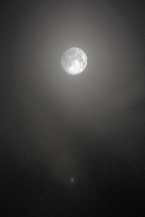
I did not take this picture however here is who did. Lets here what he has to say below.
"I took a look outside before bedtime and saw this beautiful sight!" says photographer P-M Hedén of Vallentuna, Sweden. "Going to bed was out of the question. Instead I took my camera (a Canon 450D) outside, made three exposures, and combined them to create the image shown above."
So when is the real Harvest Moon? Well the real Harvest Moon of 2009 will be on Oct. 4th. That is when I want you all to get out, View the sky, And snap those pictures so we can all see the beautiful moon here on Justin's Indiana Weather Blog AKA JIWB. :) That is the mission should you choose to except it! :) LOL.
WOW Besides the moon what do we have to talk about this week?? With all this wonderful weather we have been seeing there is just no weather to talk about l0l. However I'M just fine with that! However come winter I want to be tracking some BIG WINTER STORMS! (Snow) not ICE!!!! We had enough of that last year! And Mary Anne has had her time with ice storms. I remember the pictures she sent into Mikes Weather Blog and the story to go along with it! AMAZING! But very very scary! I'M going crazy working on the winter outlook for this year and as soon as I have it fine tuned I will be sure to post it here for you all to view.
Now remember when I added a new member to the Indiana Weather Blog who was my Parakeet Memo? Well, Memo now has a new buddy! Yes, my sis just got a parakeet not to long ago and they are the BEST of buds! The only problem is Memo, is a Boy and My sisters parakeet is a girl! Ugh LOL. You can see in this picture below that Memo, is totally in love Ha Ha ........ This is just to funny! :D
Memo, is on the right. LOL. I love this shot! :) Just so you all know we watch them closely! ;) You can't really tell in this picture however my sisters Parakeet or the left is a yellow, Blue, Light Blue, White, Gray, and Black color. Rare yes, And when one tweets the other just has to get a say as well Ha Ha. Just wanted to show you all the newest member!
And now the quick cast blog cast.
Today we will see more Mostly sunny skies with a few high clouds possible. We will feel slightly warmer with highs right around the upper 70s to low 80s. Loews will be in the middle 50s. I don't think gusty winds will be a problem today with light winds between 5 and 10 mph.
Saturday the start of the weekend is also looking good at this time! We will see more partly cloudy to mostly sunny skies. Highs right around average in the low 80s around 81* degrees. Lows will also be mild around 57* degrees. Winds will be even lighter between 3 and 5 mph with a few light gusts to 10 mph possible. If you can even call that a gust :)
Thanks for reading. I'M off to get something to eat. A late snack! Ha Ha. I will check back soon....................
Wednesday, September 2, 2009
Looking At Old Posts. Thank You All For Everything!
Well, Bloggers I want to give you all reading a BIG BIG BIG THANK YOU!!!! Why you ask?? Well, my sister was just going through some of my old post before I switched to wordpress and was reading some of your wonderful comments! I just wanted to really let you all know how much I love your kind words and your love for this blog. Remember this blog would be NOTHING without all you guys and girls. Without you it would just be a blank site of weather. I would be talking to myself lol. :) You all love this blog so much and I really really really want to thank you all for everything. For all your support, for all your comments, and most of all for reading, You bloggers really are the best there is.
I remember when I first started out on Mike Prangley weather blog. I had went to WLFI to see Mike for my 15th birthday. My Aunt set it up. A thanks to her. Mike was more then happy to have me come in for the 5:00pm news. He showed me everything he did and all the amazing weather tools. I always had a spark for earth science however Mike really got me into it and after that evening I knew this is what I want to do! After that I came back home and just read his blog for the first few months. After that small earthquake we had. I think you all remember?!?! :) That is when I first posted. I had so many stories from my neighbors I had to post them. The funny thing is I slept right through it lol :) Anyway, That is when I started posting on mikes blog. After I seen how much fun blogging was and how much I enjoyed talking about weather with all you I thought I would start my own blog. It was around six months before anyone from Mikes blog found me because I did not want to post the link on his blog. After all that is "His Blog" Not a place I wanted to post mine. I felt that would be taking from him and I would NEVER do that!
Finally some one found me lol. After Mike had to move I felt it was up to me to help keep everyone posted in storms with everything I know from Mike and many many books lol. I know WLFI still has a blog up and going however we where all the Prang Gang and we all feel like we know each other. I felt it was the right thing to do. I guess what I'M saying is I want you all to know how much you Bloggers mean to me. When I seen how many posted and really cared about this blog I now know I cannot quit anytime soon :) And I wont! Just reading those comments makes me feel AMAZING! For being 16 and home schooled this blog is a big deal to me. And it has become much bigger then I ever thought it would! Never would I have thought so many of you from Mikes blog would follow me.
((Thank You))
Now because of all this nice weather we have seen and will continue to see this week I will just do a quick cast and also I have a Beautiful picture to show you all! And I will get to that here in just a minute. First it is quick cast time.....
Quick Cast Blog Cast.
Today we have more sunny skies with nice cool to mild temperatures. We will see highs in the middle to upper 70s with lows in the upper 40s still. I would keep out an extra throw blanket on the bed for at least one more night! Winds calm between 5 and 10 mph.
Thursday highs will be in the upper 70s and lows in the low 50s. We will see some Mostly sunny skies with a few high clouds not being ruled out. Rain continues to stay away. Winds will be light, Really light between 3 and 5 mph. We will be seeing temperatures this week right where they should be for this time of year which is right around 81* to 82* degrees.
Now here is the beautiful picture I wanted to show you all below.
On August 30th, a gust of solar wind hit Earth and sparked auroras so bright they were visible in arctic twilight. This is what the sky looked like over Tromso, Norway:
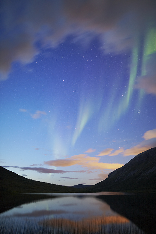 "What a pleasure to be outdoors on a late-summer evening with a warm breeze and the auroras dancing overhead," says photographer Kjetil Skogli. "I took the picture using a Canon 5D Mark II." More auroras are in the offing. A solar wind stream is heading for Earth and it could spark a geomagnetic storm when it arrives on Sept. 3rd or 4th. Residents of Alaska, Canada, Iceland and Scandinavia should keep an eye on the sky in the nights ahead.
I remember when I first started out on Mike Prangley weather blog. I had went to WLFI to see Mike for my 15th birthday. My Aunt set it up. A thanks to her. Mike was more then happy to have me come in for the 5:00pm news. He showed me everything he did and all the amazing weather tools. I always had a spark for earth science however Mike really got me into it and after that evening I knew this is what I want to do! After that I came back home and just read his blog for the first few months. After that small earthquake we had. I think you all remember?!?! :) That is when I first posted. I had so many stories from my neighbors I had to post them. The funny thing is I slept right through it lol :) Anyway, That is when I started posting on mikes blog. After I seen how much fun blogging was and how much I enjoyed talking about weather with all you I thought I would start my own blog. It was around six months before anyone from Mikes blog found me because I did not want to post the link on his blog. After all that is "His Blog" Not a place I wanted to post mine. I felt that would be taking from him and I would NEVER do that!
Finally some one found me lol. After Mike had to move I felt it was up to me to help keep everyone posted in storms with everything I know from Mike and many many books lol. I know WLFI still has a blog up and going however we where all the Prang Gang and we all feel like we know each other. I felt it was the right thing to do. I guess what I'M saying is I want you all to know how much you Bloggers mean to me. When I seen how many posted and really cared about this blog I now know I cannot quit anytime soon :) And I wont! Just reading those comments makes me feel AMAZING! For being 16 and home schooled this blog is a big deal to me. And it has become much bigger then I ever thought it would! Never would I have thought so many of you from Mikes blog would follow me.
((Thank You))
Now because of all this nice weather we have seen and will continue to see this week I will just do a quick cast and also I have a Beautiful picture to show you all! And I will get to that here in just a minute. First it is quick cast time.....
Quick Cast Blog Cast.
Today we have more sunny skies with nice cool to mild temperatures. We will see highs in the middle to upper 70s with lows in the upper 40s still. I would keep out an extra throw blanket on the bed for at least one more night! Winds calm between 5 and 10 mph.
Thursday highs will be in the upper 70s and lows in the low 50s. We will see some Mostly sunny skies with a few high clouds not being ruled out. Rain continues to stay away. Winds will be light, Really light between 3 and 5 mph. We will be seeing temperatures this week right where they should be for this time of year which is right around 81* to 82* degrees.
Now here is the beautiful picture I wanted to show you all below.
On August 30th, a gust of solar wind hit Earth and sparked auroras so bright they were visible in arctic twilight. This is what the sky looked like over Tromso, Norway:
"What a pleasure to be outdoors on a late-summer evening with a warm breeze and the auroras dancing overhead," says photographer Kjetil Skogli. "I took the picture using a Canon 5D Mark II." More auroras are in the offing. A solar wind stream is heading for Earth and it could spark a geomagnetic storm when it arrives on Sept. 3rd or 4th. Residents of Alaska, Canada, Iceland and Scandinavia should keep an eye on the sky in the nights ahead.I never seem to get tired of these pictures lol :) That is another dream of mine. I would love to see the northern lights once. That would be an amazing thing to see. Has anyone here on JIWB seen the northern lights?? If so I would love to here about it!
Again I want to thank you all very much. You all ROCK! Have a wonderful day bloggers. I will check in again real soon.
Tuesday, September 1, 2009
Indiana Has B-E-A-Utiful Weather To Talk About!
We was really cool temperature - wise last night. we was near record lows here in Lafayette with the record low being 46* degrees set back in 1986. I had to put on a thicker blanket on my Parakeet's cage last night to keep him warm. The good news is it was GREAT sleeping weather with the windows open. And this is the first sign of fall. The first day of fall is on the 22nd of this month. Yes we are at the start of another month. Happy September Bloggers. Fall is almost here and Boy it has sure felt like it the past few days.
Some good news you Bloggers might like is we will finally be right at average for this time of year starting tomorrow. Average for this time of year is right around 81* to 82* degrees and that is right where we are expected to be this week. So for those who are not ready for cool weather just yet! Well you got this week of average temperatures. Which is not bad! This should feel not to hot and not to cool. Also I have MORE good news weather - wise for this week! Take a look below.
Yes, this is the weather story for this week above. You can see this map I have put together for you all. We are calling for some Nice CLEAR SKIES all thanks to this High pressure system that is sticking around our area and keeping the clouds away. So this means nice crisp clear air for the WLFI viewing area this week. Here is your quick cast blog cast I have put together below.
Today we will expect Clear skies as the high pressure system sticks around. We will look for highs in the middle 70s and lows in the upper 40s around 48* degrees. Winds I expect to be calm between 10 and 15 mph with a few gusts possible to 18 mph. Nothing BIG to report there :)
Wednesday is also much of the same with more Clear skies again thanks to the high pressure. Also temperatures will be slightly higher but right at average. Highs in the upper 70s to low 80s and lows will also be close to average with lows being around 54* degrees. Winds will be calm again between 5 and 10 mph.
I will tell you all something. When you have weather like this it makes it hard to really talk about lol :) But it makes it REALLY REALLY EASY to ENJOY! :) And I think that makes up of it in the long run. We have been really lucky with storms this year but the question is can we continue to be lucky with the summer storms? will we see a late summer storm? Well I can tell you all that I don't see one this week! All I see for the next few days is what we talked about above!
Forecast in a word.......... Enjoyable..... ;) So go enjoy the weather! I'll check back soon.
Subscribe to:
Posts (Atom)