Sunday, October 6, 2013

Storm reports.


Well, the rain / thundershowers are making their way out of the state this afternoon as we try and dry out. Here is a look at how much rain was picked up from across the area.

Kentland, 1.13" inches

Fort Wayne, 1.08" inches

Lafayette, 1.08" inches

Attica, 0.94" inches

Remington, 0.82" inches

Rensselaer, 0.59" inches

Covington, 0.35" inches

We did have a few storm reports around the area from yesterdays weather event. Only a few high wind reports. The closest report to home was in Lebanon, out of Warren county. Take a look below.


WEST LEBANONWARRENIN
ONE UTILITY POLE SNAPPED AT BASE ... COUPLE TREES DAMAGED ... CORNFIELDS DAMAGED ...
As we head through the afternoon we will see the skies start to clear out a bit. Take a look at this satellite image below. You can see all the clearing skies heading this way as the rain showers continue to push off to the east.
Tonight we can look for partly to mostly cloudy skies with a low around 43* degrees. Winds light between 5 and 10 mph.

Monday we will start the day with partly cloudy to mostly cloudy skies with around a 30% chance of a stray shower. skies will clear as the day goes on becoming partly cloudy to mostly sunny. High around 65* degrees with a low that night around 41* degrees. Winds light between 5 and 10 mph.

Saturday, October 5, 2013

Storms moving into the Lafayette, area


This is how things look in the Lafayette, area as of 4:20pm EDT. Storms are moving into the area. We can expect gusty winds, Heavy rainfall of around a quarter inch an hour, along with lightning as with any storm.
There is around a 60% chance of small hail to the north of Lafayette. Nothing severe with this cell as of now.

Scattered thundershowers across the area this afternoon / Sunday.

A few scattered thunderstorms / thundershowers will be moving through the area this afternoon / evening into the overnight hours and on into early Sunday. We're already seeing cloudy overcast skies across the Midwest as scattered thundershowers are popping up. You can see in this local radar image below taken at 1:21pm EDT.
Currently none of these cells are severe. We do have a slight risk of severe weather issued by the National weather service however I believe that most of these cells around our area will be isolated to moderate thunderstorms rather then severe. I'm looking at a 90% chance of rain however a 65% to 70% chance of actual thunderstorms. Our current Total totals index sets around 44 to 46 which indicates isolated thunderstorms possible rather then strong, as well as our Lifted Index (LI) that sets around 0 to -1 which also supports isolated thundershowers rather then strong storms this afternoon. Still I cannot rule out the minor chance of a stray strong storm in the area.

We're seeing these storms from along a cold front that will make its way through the area later this evening / into tonight. Here is a look at the current surface chart below.
As we head into the evening / overnight hours today we will see these scattered showers become more well formed and compact as they push through the area. More widespread rain across the state. Right now I'm looking for rainfall between .10" and .25" inches tonight with higher rainfall by the time we head into Sunday where we could pick up anywhere between .25" and .60" inches of rain.

Here is a sneak peak into how things should look later this evening around 8:pm EDT.
Scattered showers continue off and on into early Sunday, Here is a chart looking into Sunday morning around 8:am EDT below.
Expect showers Sunday in the morning hours, Mostly cloudy skies otherwise, showers should start to tapper off sometime between 12:pm and 2:pm EDT.

Expect a low tonight as the cold front moves through the area of around 58* degrees, A high Sunday nice and cool around 68* degrees with a low that night around 47* degrees. I'm still not seeing our first frost in the area as of now, However it's looking like we can expect one between the 11th and 20th.


Tuesday, October 1, 2013

Blue / Green Light Over Lafayette, Indiana?! September 27th A Meteor Exploded!

My fiancee, myself and soon to be mother in law was sitting outside the other night enjoying a small Autumn fire when we saw a flash of light, blue-ish / green-ish in color. It looked like a streak of light that started from up high in the sky and falling toward the ground. Almost like a firework however we couldn't hear any sound. We wondered what it was but then soon brushed it off like no big deal. I couldn't let it go and kept looking online for something to explain what it was. Turns out, it was a meteor that exploded over Columbus Ohio! And there were MANY MANY reports of the event!

It was reported that it could be seen from at least 14 US states! Here is a chart showing where it was seen below.
I also found a video of the meteor exploding from Greenwood, Indiana. This is pretty much how things looked for us in Lafayette, as well. No sound just a quick streak of light! Pretty amazing! Take a look.


Here is a little more detail on the event from the Space Weather web sight below.

OHIO FIREBALL: On Sept. 27th, A lot of people reported seeing a blue / green-ish light in the night sky! Turns out it was a meteor that exploded in the skies above the US midwest. Some Witnesses reported shadows cast upon the ground, unusual sounds, and a swirling contrail marking the aftermath of the blast. 

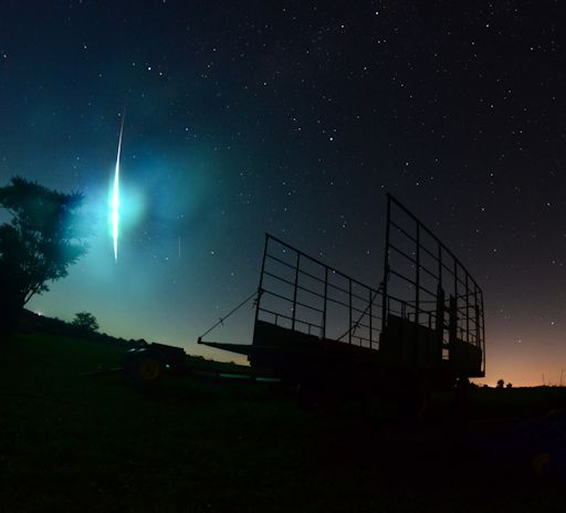
"It was the most brilliant fireball that I have ever seen!" reports Angela McClain, who sends this picture from Faith Ranch in Jewett, Ohio:

This image is from www.spaceweather.com As well as some of the reports.
"The entire landscape lit up," she continues. "I spun around and there it was, a huge, bright green light, streaking across the sky. Even when it was gone, there was still a bright line in the sky about 20 seconds later. We were all stunned."

"This was a very bright event," says Bill Cooke of NASA's Meteoroid Environment Office. "Flares saturated our meteor cameras, and made determination of the end point (the terminus of the fireball's flight through the atmosphere) virtually impossible. Judging from the brightness, we are dealing with a meter class object."

Data from multiple cameras shows that the meteoroid hit Earth's atmosphere traveling 51 km/s (114,000 mph) and passed almost directly over Columbus, Ohio. According to the American Meteor Society, the fireball was visible from at least 14 US states!!
~~~~~~~~~~~~~~~~~~~~~~~~~~~~~~~~~~~~~~~~~~~~~~~~~~~~
~~~~~~~~~~~~~~~~~~~~~~~~~~~~~~~~~~~~~~~~~~~~~~~~~
So if you were outside late on the 27th of September 2013, Well, now you know what you saw! :)

Have a great day bloggers!