
We did see a lot of rain but on the other hand we was rather lucky! We did see that dangerous lightning packed cell push through the area early yesterday morning and it gave way to heavy down pours in not only Lafayette, but before it got to us my friend Heidi, in Fountain County, Went to Attica, She was driving to the store and she got hit hard with the down pours. She said it was so heavy so could hardly see the road if that tells you just how bad it really was! My weather Cam was doing a great job picking up on all the dangerous lightning and thank goodness everybody remembered there Lightning safety tips!..........There was a lot of Hail reports in IL, and one was with that cell we seen. IL, did get hit hard with Hail as they seen hail from .75" inches all the way up to 1.75" inches. Now I thought I would look and I did find a picture of Hail around those sizes. This is not from all the Hail IL, seen yesterday but will still give you a good idea as to what they seen.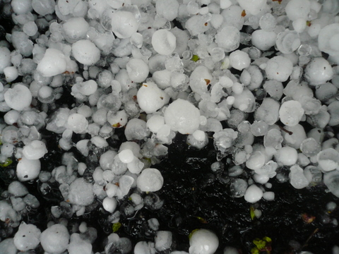
Hail can be very dangerous. If you think about it would you want to get hit on the head with a baseball size or bigger Hail stone??? ..........Well, I hope not! There have been MANY people lost there lives do to Hailstones in Hailstorms. And many Hailstorms caused Millions of dollars in damage in past years. Here is a little something for you to look at from May 18th 2000 with hail much like what you see in the picture above.
----------------------------------------------------
18 May 2000
McHenry, Lake, northern Kane, and northern Cook County, Illinois, USA
$572 million. Golf ball-, baseball-, and softball-sized hail damaged roofs, cars, patio furniture, skylights, and windows in the area's worst and most widespread hailstorm in 30 years. Around 100,000 homes lost power. Hail was 3 inches (76 mm) deep in many areas. There were 100 canceled flights, and train service was disrupted.
----------------------------------------------------
And one more thing while we are talking about hail I wanted to show you! Above is a great map to show you just how the smallest to biggest hail stones are formed.
Strong updrafts in strong storms are the main key. The updraft keeps tossing the hailstones up and around in the cloud allowing them to come together with supercooled raindrops and other smaller hailstones making them bigger and bigger this can repeat it's self many many times. Sometimes a hailstone can break out of the updraft and start to fall to the surface, And sometimes if the updraft is strong enough it can pull the hailstone back in and allow it to again come together with raindrops and other small hailstones until it becomes to heavy for the updraft to hold up only then will it start to make it's way down to the ground. By this time it's size can be anywhere from Golf Ball size to The largest hailstone ever officially recovered. Here is a picture of it I found and posted below.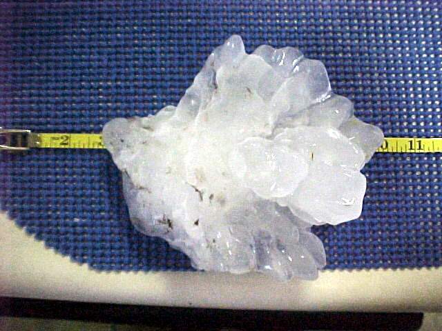
The largest hailstone ever recovered, 7 inches in diameter and almost 19 inches in circumference.
----------------------------------------------
Now let's talk about what we have to look forward to today. Well, the answer to that is Snow showers. Yes, snow showers in Spring! It is not uncommon for this time of year as we do average around 1.9" inches of snow this month. Now I don't think we will hit that today but we will still see some snow showers and maybe the chance for a little sticking snow in grassy areas! Yes, looking at this map I have put together above does show possible higher amounts way to our north around Gary, and South bend, Indiana with a possible Inch to maybe Two inches. And Much of the WLFI viewing area looking like less then a half inch with a Dusting in grassy areas. And south of Indianapolis we will keep in mostly just snow showers to flurries off and on through out the day. Now, winds will be Blustery as we could see them between 15 and 25 mph with a few gusts possible to 30 mph. I really hope you did not put away your winter coats just yet! I know it's spring and a lot of people got there flip flops out but it might be a little early lol.
Yes, looking at this map I have put together above does show possible higher amounts way to our north around Gary, and South bend, Indiana with a possible Inch to maybe Two inches. And Much of the WLFI viewing area looking like less then a half inch with a Dusting in grassy areas. And south of Indianapolis we will keep in mostly just snow showers to flurries off and on through out the day. Now, winds will be Blustery as we could see them between 15 and 25 mph with a few gusts possible to 30 mph. I really hope you did not put away your winter coats just yet! I know it's spring and a lot of people got there flip flops out but it might be a little early lol. We do have that Freeze warning out until Tuesday morning for the area as I'M looking for our low tonight to fall to 27* degrees. (COLD) is the word of the day! We may see a few left over snow flurries on Tuesday then we will have a nicer day on Wednesday with a few peaks of sun and some warmer temperatures.
I will pop in today if needed. Otherwise have a great day and LET IT SNOW!....................Have a good and warm day.....
1 comment:
Awesome info about hail Justin.
Had to clean snow off my car windows this am. Is pretty out now, yet very windy.
Thanks for the update, and your blog looks great!
Teri
Post a Comment