
 This picture was taken at 52 and union. You can see the roads are still a mess at this time. totally snow covered! This is why the county travel status is at a level 3 in Tippecanoe with talk about a level 2 warning! Remember that Warren, county is now under a level 2 Warning. And Fountain, county is still under a level 2 Warning as well. And just a few minutes ago Clinton county was put under a level 3 watch! So it is best to stay home if at all possible! Again here are the meaning of both the level 2 and level 3 below.
LEVEL 3 WATCH.This means that routine travel or activities may be restricted in areas because of a hazardous situation.You should use caution or try to stay home if possible!
LEVEL 2 WARNING. This means that conditions are treating to the safety of the public. Only essential travel is recommended. As in to and from work / Emergency situations ect... Emergency action plains have been or should be implemented by businesses, schools, government agencies, and other organizations..
~~~~~~~~~~~~~~~~~~~~~~~~~~~~~~~~~~
~~~~~~~~~~~~~~~~~~~~~~~~~~~~~~~~~~~~
Now lets take a look at the total snowfall at this point and time below.
 As you can see between both the old and new snowfall we have a ground total of 4.50" inches. However we picked up a good 4.00" inches today alone for this huge system that is pushing through. And we are still look for another 1" inch possible by Friday. This will be from the snow that is to our north on the back side of this system. You can see what I'm talking about in this image below.
 You see all the blues to the east of our great state. This is what has pushed through earlier this morning though the afternoon hours. Now because of the counter clockwise flow of the low pressure system we will see the snow to our north start to push through giving us another change a at light inch possible by tomorrow. however snow is not the only thing we will see! Yes, the winds are going to start to pick up between now and 6:00pm EST this evening. We will see winds between 5 and 10 mph however they could gust between 15 and 20 mph without any problem. This will be a threat with the roads as this snow is so light it will blow and drift over roads like crazy! So driving in the evening hours will be dangerous and tricky! Again drive SLOW or Stay HOME if you can... Also COLD polar air is really going to set in and take over for the next few days. Take a look at this map below.
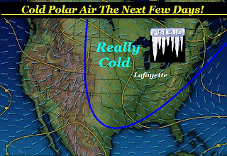 That's right the Indiana area is going to feel FRIGID for a little while. Tomorrow / Friday we are going to see highs around 14 degrees with lows dropping into the single digits. Yes, around 8 degrees possible! Now with winds blowing around 10 to 15 mph this will make our daytime high feel around 3 degrees. However our nightly low will feel around -4 to -6 degrees! Brrrrrrrrrrrrrrrrrrr Is the word of the day! Be sure to take an extra blanket to bed and keep your pets warm as well. Just like you and me they to get cold!
Now here are the current winter storm warnings as well as the winter weather advisories below. Stay safe Bloggers and stay warm. I will check back soon with more and final snowfall totals from around the WLFI viewing area later on... It's still snowing and we will continue to add it up til the last flake falls! ;)
Winter Weather Advisory
CARROLL-WARREN-TIPPECANOE-CLINTON-HOWARD-FOUNTAIN-MONTGOMERY-
VERMILLION-PARKE-
INCLUDING THE CITIES OF...LAFAYETTE...FRANKFORT...KOKOMO...
CRAWFORDSVILLE
...WINTER WEATHER ADVISORY REMAINS IN EFFECT UNTIL 7 AM EST
FRIDAY...
...WINTER STORM WARNING IS CANCELLED...
~~~~~~~~~~~~~~~~~~~~~~
~~~~~~~~~~~~~~~~~~~~~~~~~~~~
Winter Storm Warning
Benton, Newton, Jasper Counties.
...WINTER STORM WARNING REMAINS IN EFFECT UNTIL 9 AM CST /10 AM
EST/ FRIDAY...
4 comments:
Wow, we had a small break in the snow, has been moderate snow since around 2:00.
With the litte wind we have, its sure blowing things around!
Yes all stay home if you can.
Be safe! Teri
Thank your paper carriers who are out in this even before the highway departments are,,,,,Becky in monticello
Our mail man was out before the roads were plowed, he came in for a moment for a cup of coffee. Yes thank you paper couries, mail people, garbage men and street dept. tough jobs!
Hey Justin, Its still snowing out here in the Mulberry- Dayton area and on the radar it shows nothing. Can you tell me why?
Post a Comment