
 I think that the highest amounts will be between Montgomery county and north! That's why I have us in the 1" to 3" Inch range with some areas picking up closer to 4" Inches possible! And then a better 2" to 4" inch range north of Tippecanoe county. This is a Huge system for sure!!! And it's going to be here sooner then what I was thinking last night. I'm thinking around 1:am EST tonight.
Tonight's forecast...
We will look for snow showers all night through out all day Saturday! Expect snowfall totals tonight around that inch mark. Lows will be around 25* degrees with a light wind between 3 and 5 mph. This will only make for a small wind chill of 19* degrees.
Saturday we will look for Snow showers through out the day with a few left over snow flurries / snow showers into Sunday. New snow accumulation between 1" and 3" inches possible. Highs will be in the 30s around 33* degrees with lows cool around 18* degrees. Winds will be between 10 and 15 mph. This will make for a windchill of 7* degrees.
~~~~~~~~~~~~~~~~~~~~~~~~~~~
~~~~~~~~~~~~~~~~~~~~~~~~~~~~~~
~~~~~~~~~~~~~~~~~~~~~~~~~~~~~~
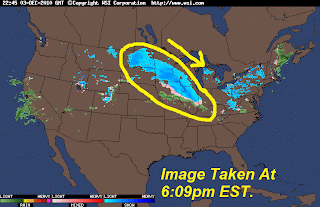
You can see in this image below that we look like we will have enough moisture to work with as this system moves into the area.
Inside the yellow lines is all the moisture in this system. So this makes me feel a little better about calling for at least 1" to 3" inches with this snow storm! And take a look at the size of this thing! This is pretty big for a clipper system.
 Just amazing!! And one thing that I will be watching tonight is the heaviest band of snow and where it sets up! Right now it's looking like right around Tippecanoe county, and around around areas!! Take a look at it below.
 This is why I'm keeping that patchy 4" inches in the forecast! ;)
Now we do have that Winter weather advisory out for the WLFI viewing area! Here it is again below.
...WINTER WEATHER ADVISORY IN EFFECT FROM 1 AM TO 7 PM EST
SATURDAY...
THE NATIONAL WEATHER SERVICE IN INDIANAPOLIS HAS ISSUED A WINTER
WEATHER ADVISORY FOR SNOW...WHICH IS IN EFFECT
FROM 1 AM TO 7 PM EST SATURDAY.
* ROADS MAY BECOME SLIPPERY DUE TO SNOW AND THUS MAKE TRAVEL DIFFICULT.
SATURDAY...
THE NATIONAL WEATHER SERVICE IN INDIANAPOLIS HAS ISSUED A WINTER
WEATHER ADVISORY FOR SNOW...WHICH IS IN EFFECT
FROM 1 AM TO 7 PM EST SATURDAY.
* ROADS MAY BECOME SLIPPERY DUE TO SNOW AND THUS MAKE TRAVEL DIFFICULT.
~~~~~~~~~~~~~~~~~~~~~~~~~~~~~~~~~~
~~~~~~~~~~~~~~~~~~~~~~~~~~~~~~~~~~~~
~~~~~~~~~~~~~~~~~~~~~~~~~~~~~~~~~~~~
Please be VERY careful and allow extra time to get where your going if your heading out in the morning. Roads will be slippery with that inch of snow covering them. And with temperatures dropping to 25* degrees we can expect to see some patchy ice in areas as well. So please allow extra time so you can take it slow!
Stay safe bloggers and weather watchers! I'll will check back again soon!
LET IT SNOW, LET IT SNOW, LET IT SNOW!!!!!!
GOD BLESS! :)
1 comment:
I am happy for you Justin ;) I know the first real snow fall will be pretty, the the temps grrrr...
Teri
Post a Comment