
Lets get to it!
A storm that had been predicted for days caught much of the East Coast off guard with its ferocity, tearing through with lightning, thunder and tons of wet snow, stranding thousands of road, rail and air travelers, and leaving more than 400,000 customers around the nation's capital without power Thursday.
The storm had been forecast as dumping up to a foot of snow on parts of the region but far surpassed that in spots. New York got 19 inches, Philadelphia 17" inches. Public schools closed for a second day Thursday, including the nation's largest system in New York City, And motorists were warned to stay off slick roads.
 Photo Above: A maintenance man cleans snow off the sidewalk along Riverside Drive on New York's Upper West Side after the overnight snowstorm.
The region has already been pummeled by winter not even halfway into the season. About 19 inches of snow fell on New York City atop the 36 inches it had already seen so far this winter. The city typically sees just 21 inches for the whole season. And as you can see, They are WAY passed 21" Inches. Currently standing somewhere around 57" Inches give or take a little! And this is just the New York area! What about other places?

Photo Above: Heavy snow created this scene in the Boston area earlier this morning. January 27th 2011.....
"This is my block with no where to pile the snow as it just avalanches down every pile. January 27, 2011 Snow Storm - Flushing, NY. Today it was declared that we have had the most snow in the month of January EVER!"
Jackson Heights, Queens New York. January 27th 2011.....
"Recorded on January 27, 2011, A limo is stuck in the middle of a congested intersection in Jackson heights, Queens."
The Greater Boston Areas Of Massachusetts. January 27th 2011.....
"I film off of my balcony people digging out from the Snow Storm that Hit The Greater Boston areas of Massachusetts On January 27, 2011."
~~~~~~~~~~~~~~~~~~~~~~~~~~~~~~~~~~
~~~~~~~~~~~~~~~~~~~~~~~~~~~~~~~~~~~~
After viewing all of this that took place over last night in the Northeast it sure does make it seem like Lafayette, hasn't seen much over a dusting all year lol. I think we can take whatever snow comes our way in stride! Knowing that we could be like New York, and trapped under 20+" Inches of snow.
So what do we have to look forward to here in the Midwest?
Well, as you can see in this radar image above, We did see some snow move across the viewing area earlier this afternoon giving way to a few quick burst of snow in areas. This image above was taken at 1:pm EST. I have some video sent in from one of our weather watchers, Brow. He took this video around 1:pm EST this afternoon of the bigger flakes coming down around the Monticello, area. Take a look.
Brow, "Snow just started dumping and thought that I would try a quick Canon 60D HD video test with it."
He also sends us this still image. He says It’s in HDR so it looks a little funky lol. But hey we like Funky things here on JIWB :)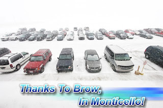 This picture was also taken in the Monticello, area around 1:pm this afternoon. A big thank you to Brow, for sending in some I Witness pics and video of the snow in our local area! Keep up the Awesome Work! :) If any of my bloggers would like to send in weather Pictures, Video, or Weather Reports, you can send them to me at dobby1717@aol.com Thanks Ahead Of Time!
Another Snow band moved into the area in the evening hours. You can see the snow starting to cover the viewing area in this radar image below. It was taken at 5:31pm EST. The darker blues are the heavier snow bands. You can see much of the WLFI viewing area covered in the snow at 5:31pm EST. Here a picture I took at 5:30pm EST in Lafayette below.
 Lots of dime sized snowflakes falling across the area. You can even see the icicles formed along the roof. Ahhhhhhh I love winter lol. This will pretty much be the story as we continue into the overnight hours! Some scattered show showers across the viewing area giving way to an inch or less of snowfall. However the more north you go in the viewing area the slightly higher the amounts will be from our southern counties.
Here's a video I also took in the Lafayette, area around 5:30pm EST this evening.
Again this is pretty much what it will look like as the evening continues. Here's look at your quick cast below.
Quick Cast.....
Tonight expect a low around 19* degrees with winds between 4 and 7 mph. Also light scattered snow showers across the area. Snowfall around an inch or less. Expect slightly higher amounts the more north you go.
Friday we will look for partly to mostly cloudy skies across the area. Clouds will be on the increase as the day continues. I also still have around a 20% chance for a few scattered light snow flurries across the area later on that night into early Saturday. Expect a high around 31* degrees with a low Friday night around 27* degrees. Winds between 5 and 8 mph.
Saturday we will look for a few light scattered snow flurries in the early morning. A few breaks in the clouds will be possible in the afternoon however overall we will be mostly cloudy. More clouds move into the area that evening / night. Highs will be around 36* degrees with lows that night around 22* degrees. Wind light between 3 and 5 mph.~~~~~~~~~~~~~~~~~~~~~~~~~~~~~~~~
~~~~~~~~~~~~~~~~~~~~~~~~~~~~~~~~~~
5 comments:
Probably one of your longest and best posts yet!
We are getting dumped on right now in Monticello!
Thanks Brow!
Snow's coming down pretty good right now in Lafayette, as well.
Justin.
Thanks for your input on the forcats.. i mean forcast, meow.
Justin, lots of people talking about the possibility of a big snow next week....They are saying some models are beginning to show a rare Miller Type B sytem. What do you know about this type of system. What do you think our chances of this coming to fruition are?
Thanks,
Duane
Hey Duane,
I'll try to answer your question in tonights blog post!
Be sure to check back.
Justin.
Post a Comment