
Hey bloggers! What a nice day it was today. Partly cloudy skies across the area and a high in Lafayette, of 61.4* degrees! Woooo Hoooooo! ;) hahaha It just doesn't get any better then that! I spent the day outside helping my family do some spring cleaning. I also had to replace some wood on one of our decks. The wood rotted out over the winter. Good news is I had a nice day to get out there and get the job done! And it looks much better now. Just take a look at the satellite image taken at 5:45pm EDT this evening.

Yes, you can see a few high clouds however it was still a great day! Partly cloudy. I'll take it :) Good news is this mild weather is going to continue over the weekend into next week! A little rain is possible by Friday however it's not looking like much at all at this time.
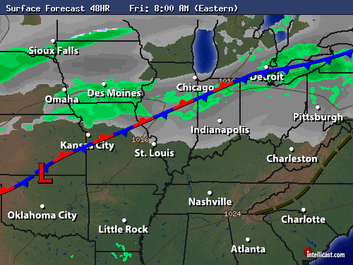
You can see above looking at the Friday morning surface chart that this slow moving stationary front is what will cause for a few light hit and miss scattered rain showers. Again nothing heavy however rain is rain and I must forecast it! lol. Here's your detailed quick cast below.
Quick Cast.....
Thursday we will look for partly cloudy skies across the area through out the day. A few more clouds may try to move into the area by Thursday evening / night. Breezy! Expect winds between 10 and 15 mph gusting between 25 - 28 mph. I look for a high Thursday around 67* near 70* degrees with a low around 50* degrees.
Friday we will look for partly to mostly cloudy skies across the area. A few light scattered hit and miss rain showers are possible. Rainfall around a tenth inch or less. Look for a high Friday around 66* degrees with a low that night around 36* degrees. Winds between 5 and 10 mph.
~~~~~~~~~~~~~~~~~~
~~~~~~~~~~~~~~~~~~~~~~~~~~
~~~~~~~~~~~~~~~~~~~~~~~~~~
Now bloggers this week is Severe Weather Preparedness Week! Which means I'm gonna talk to you all a little bit about severe weather safety. So lets get to it!
Tornado And Severe Weather Safety

A TORNADO WATCH is normally issued for a large area covering a whole state or a large part of several states. The WATCH is intended to give you time to prepare, time to review safety rules. The sky may be blue, but weather changes could be just over the horizon. Begin preparing when you hear the watch.

TORNADO WARNING is broadcast when a tornado has been detected by radar or a tornado has been reported. A TORNADO WARNING is usually issued for one or two counties. If the tornado warning is for your county, you should seek a safe shelter immediately.
Before a watch or warning is issued, National Weather Service meteorologists may issue special outlooks and/or place wording within forecasts to alert you to possible severe weather ahead. The intent is to keep people informed and aware.
Safety Rules

In general, get as low as you can. A basement below ground level or at least the lowest floor of a building offers the greatest safety. And, put as many walls between yourself and the outside as possible. Avoid windows at all cost!
Homes or small buildings: go to the basement or to a small interior room such as a closet or bathroom or an interior hall on the lowest level. If available, get under something sturdy like a heavy table. Protect yourself from flying debris with pillows, heavy coats, blankets, or quilts.
Schools, nursing homes, hospitals, factories, and shopping centers: go to a pre-designated shelter area. Basements are the best, but interior hallways on the lowest floor usually offer protection. Close all doors to the hallway for greater protection.
Mobile homes or vehicles: leave them and go to a strong building. If there is no shelter nearby, get into the nearest ditch and lie flat with your hands shielding your head.
Stay away from windows! Don't bother opening or closing them. It won't protect the structure anyway. You'll just waste time and put yourself, and possibly others, at greater risk. Use those valuable seconds to find a place of safety.
Stay away from doors, windows, and outside walls. Protect your head!
Thunderstorms!

A severe thunderstorm is defined as having wind of at least 58 mph and/or hail ¾ of an inch in diameter or larger. Severe thunderstorm winds can gust to more than 100 mph, overturning trailers, un-roofing homes, and toppling trees and power lines. While dime size hail denotes a severe thunderstorm, hail as large as grapefruit has occurred. The danger to serious injury from hail is not hard to imagine when you consider that a good-sized hailstone may fall at speeds near 110 mph.
The best defense against thunderstorms is to stay inside a substantial building. Thunderstorms do not usually last for a long time and will generally pass in less than an hour. When thunderstorms are expected, be sure to pick up loose objects around your home or business. Small items can become deadly in strong wind, and flying debris can cause serious damage to other property.
Lightning - The Underrated Killer

Take some time now to learn or refresh your memory on lightning safety rules. That quick dash out in the open when a thunderstorm is in the area may unnecessarily expose you to the possibility of being struck. Is it worth the risk?
Lightning Safety Rules
Inside a home, avoid using the telephone except for emergencies. Also, stay away from windows.
If you're outside, get into a building or in an all-metal (not convertible) vehicle
DO NOT stand beneath a tall isolated tree, or in an open area.
AVOID projecting above the surrounding landscape as on a hilltop, in an open field, or a beach, or fishing from a boat.
Move away from open water or from tractors or other farm equipment.
Get off and away from motorcycles, scooters, golf carts, riding lawn mowers, and bicycles. Put down golf clubs.
Stay away from wire fences, clotheslines, metal pipes, rails or other metallic paths which could carry lightning to you from some other distance away.
Avoid standing in small isolated sheds or other small structures in open areas.
In a forest seek shelter in a low area under a thick growth of small trees. In open area, go to a low place such as a ravine or valley. Be alert for flash floods.
If you feel your hair stand on end, this indicates that lightning is about to strike. Drop to your knees and bend forward putting your hands on your knees. Do not lie flat on the ground.
Remember, there is no truth to the old myth that "lightning never strikes twice."
~~~~~~~~~~~~~~~~~~
~~~~~~~~~~~~~~~~~~~~~~~~~~
So bloggers be sure to follow the tips above and do your best to stay weather ready! Earlier today I went ahead and put together a first aid kit. If you don't already have one then you should really think about getting one together ASAP! Also it's a GREAT IDEA to have a weather radio! These can be life savers. Why? Because at night time they can wake you up if a Watch, Warning, Or Advisory, is issued!
So please do your part to be weather ready and stay safe.
Take Care bloggers and God Bless!
2 comments:
Hey Justin! I still read everyday but you haven't mentioned anything about Saturday's Super Moon! :)
Looks like we should have a clear night for viewing.
http://science.nasa.gov/science-news/science-at-nasa/2011/16mar_supermoon/
Yes!! Thank you Brow! I will make sure to have this in my post tonight!
Justin.
Post a Comment