
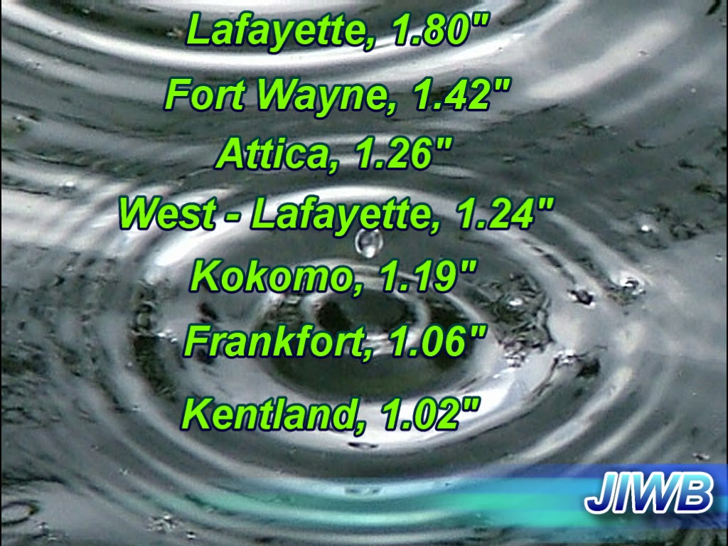
Take a look at these final rainfall totals above from around the area last night. It seems no one has any less then at least an inch of rain after this one! If you have a garden then it definitely got it's watering out of this system! I hopped into the car last night and did a quick drive around however I couldn't find anything but a few small tree limbs down do to high winds and some localized flooding on some roads do to all that heavy rainfall! However once I got up this morning I found some deck tables and umbrellas blown into the fence of the garden.

Good news is that's about all the damage we seen in my neighborhood! However I do have many many high wind reports for all areas of the viewing area! And even some small trees down in areas of Lafayette!
Some steady wind gust reports from around the area around 40 mph were reporded last night. Take a look.
Kokomo, 46mph.
Fort Wayne, 45mph.
Lafayette, 44mph.
Remington, 44mph.
~~~~~~~~~~~~~~~~~~~~~~~~~~~~~
This was steady wind gusts. However higher peak wind gusts were reported. And those peak wind gusts are what is associated with these wind damage reports below.

All the blue areas are the high wind reports and or wind damage reports! Just amazing how much this storm report map blew up last night! (Amazing) Take a look at these wind reports below.
| CRAWFORDSVILLE | MONTGOMERY | IN | TRINITY MISSION FACILITY GARAGE AND SHED DESTROYED, TREE UPROOTED, TREES DAMAGED, FLAG POLE DESTROYED, SOME DAMAGE TO MAIN BUILDING | <>
| 2 WSW RENSSELAER | JASPER | IN | LARGE TREE DOWN ACROSS SOUTH COUNTY ROAD 1200W BY IROQUOIS RIVER. TIME ESTIMATED. |
| LAFAYETTE | TIPPECANOE | IN | TREES DOWNED ON SOUTH SIDE OF TOWN. |
| MULBERRY | CLINTON | IN | TREES DOWNED. |
| MULBERRY | CLINTON | IN | GRAIN ELEVATOR DESTORYED. PART OF A BUILDING BLOWN IN . HOME DAMAGED. |
| CRAWFORDSVILLE | MONTGOMERY | IN | TREES DOWNED. ESTIMATED 80 MPH WIND GUST. |
| 1 SE TWELVE MILE | CASS | IN | TV ANTENNA BY HOUSE BENT DOWN. ROOF OFF GARAGE. |
As you can see lots of damage across the viewing area all because of those straight line winds. Some reports of winds to 80 mph as we expected as that line neared the area. That is as strong as a weak tornado.

We all knew we were in for it when we looked inside that line of storms. It had hail 1,00" to 1.50" inch in size. Flooding rains! As you seen damaging straight line winds! And the threat of brief rain wrapped tornadoes however none have been reported thank god! But those straight winds can be just as bad sometimes!
The bow echo was just crazy with this system. over 1,600 people lost power in Fountain, county alone! WOW. Over 555 lost power in Tippecanoe, county. And there are still many without power at this time!
Still Without Power!
BENTON, IN 58
CARROLL, IN 4
CLINTON, IN 74
FOUNTAIN, IN 152
HOWARD, IN 10
MONTGOMERY, IN 312
TIPPECANOE, IN 187
As you can see we still have the clouds to deal with over the area today! However will take that any day over the storms! ;)

So I wish you all a blessed day! Take care and God Bless!
No comments:
Post a Comment