Alright. I have been looking into the 2012 - 2013 winter forecast for the past few days. Finally I have some information for you guys. But before I start I just want to point out like I do every year that this winter forecast is not set in stone! When we say that we're making a winter forecast, lets be honest, none of us ever hit it on the nose. And this is because no one can predict a season ahead accurately. All we can do when trying to forecast the winter ahead is look at past and current weather trends, Nature, and some long range forecasting models that are more wrong than they are right. All we're doing is trying to see what we can and give you an idea as to what nature is pointing to as we head into the winter season. With that said, lets begin.
One of the first things most of us look at when deciding how the winter will be is El-nino and La-nina. Which jet stream pattern will it be this year?. Well, last winter we had a La-nina jet stream pattern that was so weak it acted like a El-nino. Causing us to see a much milder and less snowy winter. However this season many believe that we could see a weak El-nino as we continue to move closer to the chilly season. One of the other things to look at are the NAO and AO models. This also helps decide what kind of jet stream pattern we could see.
What you are looking at above is whats called a Positive NAO. When we see this kind of pattern we usually see that jet stream lift to the north a bit keeping that cooler air north of us for the most part and more average / mild air in place just to our south. If we were to see a pattern like this one it would mean less snow for us in the Midwest.
Below is how things would look with a Negative NAO.
We would see that jet stream dip south causing all that cold polar air to fall south into the area. This would mean more snow for the Midwest and even above average snowfall the more east and north you go! If we see this pattern snow lovers would be happy and the east would be digging out.
So what pattern do I think we're leaning toward? Well, currently its pretty hard to say. However most models are showing signs of an average winter for much of us in the Midwest. With the NAO models right around neutral (Between both Negative and Positive). This could be a back and forth kind of year.
So I've showed you some of the science side of things. Now if you want to take a more mother nature approach to the winter forecast then take a look at this.
Weather folklore says that you can predict the winter ahead by using persimmons.
It says that if you take a persimmon and cut into the seeds then you can tell what kind of winter you will have. Once you cut into the seed you will look to see what shape it has inside. In this image above you can see the shape of a spoon. They say this would mean lots of cold and snow in your forecast. Spoon = shovel! If you cut into a seed and see a fork that would mean an average to mild winter, rather calm for the most part. A knife would mean bitter cold temperatures and harsh winds that cut through you like a knife.
I did find some reports of some people who actually cut into the seeds this year. Take a look at what they found and you can be the judge.
East Central GA. All spoons.
Orange county IN. Ten seeds and all spoons.
Franklin IN. Twenty seeds and all spoons.
Mccreary county KY. Three seeds, two spoons and one knife.
Central KY. Three spoons and one knife.
~~~~~~~~~~~~~~~~~~~~~~~~~~~~~~~~~~~
~~~~~~~~~~~~~~~~~~~~~~~~~~~~~~~~~~~~~~~~~~~
Here's what I'm leaning toward for the Midwest this winter season.
I think that most of us will see a more average winter this year. You can see in the light blue areas above. Which for snow lovers this isn't bad. Even our average winters here in Indiana, we usually see an annual snowfall of 26.2" inches.
Above average snowfall in areas east of Indiana, and Ohio. Cold and snowy north and around average / slightly milder weather south of Kentucky, and Missouri. I personally do think we will see a decent amount of storms develop in the Midwest this year. It'll be interesting to watch.
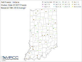
As for our first fall freeze of 32* degrees and 28* degrees for the 2012 year. Take a look at these charts below straight out of the national weather service.
Above is a look at our first fall freeze at 32* degrees. We are looking for it to be between October 1st and October 10th here in Tippecanoe, county.
And below is our first fall freeze of 28* degrees expected between October 11th and 20th to October 21st and 30th in the Tippecanoe, county area.
So that's just an idea of how things currently look for the 2012 - 2013 winter forecast. I'm sure new data will con in as we continue to inch closer to this winter and some tweaks will have to be made to this forecast. Until then have a great day bloggers and enjoy Autumn! ;)
Take care and God bless.


3 comments:
Miss snow here in Indiana, It stinks.
Keep on writing, great job!
My blog post: fresh coffee beans
Very quickly this website will be famous amid all blog viewers, due to it's pleasant articles
Feel free to visit my webpage http://code6studio.com/?p=6
Post a Comment