
We had a lot of rain and wind move through the area yesterday. Winds gusting as high as 44Mph in the Lafayette, Indiana area. Enough to knock you right off your feet. Here's a look at the peak wind gusts from around the area yesterday below.

41Mph in Indianapolis. 48Mph was the peak wind gust in Monticello. 28Mph was the peak wind gust in the Remington, area up in Jasper county. I can't believe we almost hit that 50 mph mark in Monticello! wow.
Rain was the other factor in yesterdays event. We were calling for rainfall around a quarter inch with slightly higher amounts in thunderstorms. You can see how brief and widespread the heavier rain bands were just by looking at the final rainfall totals from around the area below.
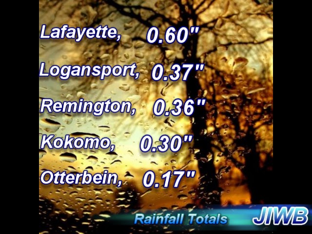
Here at JIWB I recorded a final rainfall total of 0.60" inches. Logansport, coming in with 0.37" and Remington, coming in with 0.36" Inches.
Here's a quick look at your forecast below.
TODAY- We will look for partly cloudy to mostly sunny skies across the area. Expect a high around 61* degrees. Winds light between 5 and 10 mph gusting to 15 mph at times.
TONIGHT- We will see Partly cloudy skies with a cool low around 42* degrees, winds light between 5 and 10 mph.
TUESDAY- Highs will be in the lower 70s around 72* degrees. Partly cloudy skies across the area. Winds light between 10 and 15 mph. A low Tuesday night around 52* degrees.
EXTENDED OUTLOOK- I'm currently watching another developing system over Wednesday evening into early early Thursday! This will be another strong low pressure system with a strong front that will give way to a squall line of showers / t-storms in the area. Take a look at this model below.

This model is looking into 7:pm - 8:pm EDT Wednesday night. You can see the squall line developing. Some models are already showing rainfall between 1" and 1.5" inches. High gusty winds and heavy rainfall will be a threat once again. Right now a few strong to severe storms cannot be ruled out. However I will keep you posted on this developing event as we continue to move closer to Wednesday and Thursday.
As I said in my 2012 - 2013 winter forecast. I think this is going to be a very active storm year this winter. As you can see we are starting to see a lot of active weather develop already.
No comments:
Post a Comment