Finally we have something going on in the weather world to talk about here on Justin's Indiana Weather Blog. We have been in a real calm weather pattern here in the midwest over the past few days to weeks. The biggest weather event we've talked about over the past week has been this Indian summer with highs pushing 70* degrees by this Monday! CRAZY!!! It's December 2nd and almost 70* degrees!?!? We need some cold weather to forecast, and that's just what I have in store.
But first off lets take a look at what we have to expect over the next 24 hours here in Indiana. Here's tonight's forecast below.
That's right, we have yet another chance at some foggy conditions across the area as we head into the overnight / early Monday morning. I'm looking for a low tonight around 54* degrees with dew points only a degree apart around 53* degrees. A light wind between 5 and 10 mph will make conditions right for fog. Mostly cloudy to partly cloudy skies across the area.
So when do things start to get interesting weather-wise here in the midwest? well, if you count the fog then things get interesting by as soon as tonight. If not, then by as soon as tomorrow and into Tuesday.
As we head into Monday around 7:am you can see this surface chart above showers that stationary front over the area allowing a few scattered showers to linger off and on through out much of the day. Currently for Monday I'm calling for partly cloudy to mostly cloudy skies with around a 15% percent chance of a few scattered hit and miss showers during the day hours. As we head into Monday night we will see an increase in clouds as another front approaches.
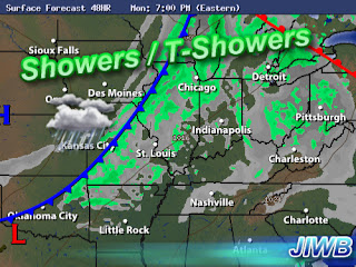
Above is a look into Monday around 7:pm EST. You can see that approaching cold front with a line of showers / thundershowers out in front. This will make its way into the area during the later hours on Monday / early Tuesday. Showers and a few thundershowers cannot be ruled out. nothing strong / severe to worry about. Rainfall is expected to be between .25" and .50" inches. Winds could pick up as we head into the overnight on Monday once this front moves in. Winds gusting anywhere between 28 and 35 mph possible. Here's your forecast break down below.
TONIGHT- we will see mostly to partly cloudy skies across the area. Lows will be around 54* degrees with a chance of light patchy fog in areas. Winds light between 5 and 10 mph.
MONDAY- expect partly to mostly cloudy skies with around a 15% percent chance of a few scattered hit and miss showers during the day hours. An increase in clouds as the day continues. Another line of showers / thundershowers move in later that night into Tuesday. Winds will be breezy between 15 and 20 mph with gusts to 25 mph. Increasing to 28 and 35 mph later that night. A high around 69* degrees with a low around 47* degrees.
TUESDAY- we will start the day with showers in the area as a cold front pushes off to our east. Expect a high around 58* degrees with a low Tuesday night around 36* degrees. skies will try to clear a bit as the day continues.
~~~~~~~~~~~~~~~~~~~~~~~~~~~~~~~~~~~~~
~~~~~~~~~~~~~~~~~~~~~~~~~~~~~~~~~~~~~~~~~~~~~
~~~~~~~~~~~~~~~~~~~~~~~~~~~~~~~~~~~~~~~~~~~~~
Looking ahead into the second week of December, things will start to get even more interesting! Winter will return in the area as I'm seeing a much deeper cold trying to set in. NAO and AO models indicate much cooler temps developing as the models fall into a negative phase. As this happens we are also watching a developing system as we head into the second week of December. It's looking like an active weather pattern setting up.
Above is a sneak peak into one of my weather models showing signs of a developing system during the second week of December. A strong low pressure system trying to develop and move northeast across the midwest. This system could very well be something to give way to not only heavy rain and windy conditions in the area but also snow! Now nothing is set in stone as this is looking ahead a week, however its something that has caught my attention and wanted to share.
Here's another look just a few hours later. You can see that trough of cold air plunging into the midwest just to the west of Indiana. (The blue lines). This is part of that deeper cold trying to set in. Enjoy these warmer days while you can, cause it's not going to last much longer. December is coming back strong! Weather is like a giant rubber band, The more you stretch it, "as in drifting away from the normal weather pattern, temperatures etc", The harder it snaps back into place! So even though the 60s have been nice for all the warm weather lovers, we're going to pay for it with this deep trough and active weather pattern setting up!
Have a great day bloggers. I'll check back soon.
God Bless.


No comments:
Post a Comment