Highs in the 60s today. In January!!! Well, we're about to pay for it. It's like I have always said, Mother nature is like I big rubber band. The more you pull it from its natural state (Meaning normal highs, lows, weather patterns, etc) the harder it snaps back to normal! And that's what we're about to do.
Above is a look at the radar image at 7:pm EST. We're tracking some thundershowers to our west out ahead of a strong cold front. This will be the story into the overnight hours. We are in a slight risk for severe weather however I'm thinking that most of the severe weather will stay in southern Indiana and then farther south from there. Still a stray strong cell cannot be totally ruled out at this time. Otherwise I believe our main threats tonight will be heavy heavy rainfall which could lead to some isolated localized area flooding. As well as high gusty winds in and out of storms!
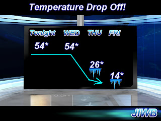
Above is a look at a surface chart for 1:am EST tonight (Wednesday). You can see that cold front moving in. Notice all that COLD and snow just to the west of this front! This is the January weather fighting back with a vengeance! Our low tonight of 54* degrees will be our high tomorrow. Instead of warming through the day our high will be falling! Take a look at the forecasted highs over the next few days below. Its a big temperature drop off..
Get ready bloggers. Stay weather ready, or should I say (Stay temperature ready). Its so hard to get use to this kind of weather pattern, its no wonder everyone keeps getting sick across the area.
I'll check back as needed with weather updates! Take care and as always, God Bless.


No comments:
Post a Comment