Saturday, December 19, 2009

Snowflakes Fall From The Sky Above! While I'm Still Watching The CHRISTmas Forecast!!

Let it snow, let it snow, let it snow!! Yes, we are on the look out for snow flakes falling from the sky above. But how much could we see when all is said and done? I have your answer!


We are watching this Alberta clipper system move in from our north and west. Now usually Alberta clippers don't give us much in the way of big snow accumulations. Usually between 1" and 3" inches. Sometimes four inches. However this time around I don't think we will break no four inches. But more around that inch and a half near two inches mark if things go as planed. Take a look at this snowfall map below.
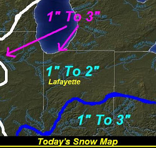
You can see I keep the better chance at the 1" to 3" inches to our south near the Indy area and then to the south and east of there. Also I have a 1" to 3" inch band well to our north around Gary, Indiana. This is because of Lake Effect snow bands. Then I think to our west as this system moves in areas of IL, could have already picked up near that 1" to 3" inch mark. Most of the WLFI viewing area I have in that 1" to 2" inch band. This is the range I'm calling for. However I don't think we will see over 2" inches. Most should stay around that inch and a half give or take a little.


Still this is enough to make driving difficult! And I know I do this every time it snows but I'm going to post more Winter Driving Safety Tips here in just a minute! You can never be to safe when it comes to slick roads and driving that's for sure!


We will look for winds to be blowing between 10 and 15 mph today. Highs today will reach into the low 30s around that freezing mark. Lows will fall into the low to middle 20s. We will look for another small Alberta clipper to try and move in Sunday into Monday however I don't look for much with that system at this time. Maybe less then a quarter inch.
~~~~~~~~~~~~~~~~~~~~~~~~
~~~~~~~~~~~~~~~~~~~~~~~~~~~


Now I know everyone is ready for the full detailed forecast for Christmas! It's less then a week away right? Well, I will say that the models are still full of one thing! And that one thing looks a lot like this "??????????????????????????????????" If that tells you anything. The good news for snow lovers and all who want a white Christmas is the low pressure is moving more to the north then what models showed us last week. Remember when I told you all that sometime these systems like to move a good 100 to 200 miles to the north and west then what models show? Well that is just what's happening! So will we see precipitation? Yes, I think that's a safe bet at this time. Will it all fall in the form of snow? That's the question! See the MOS models are calling for temperatures to be to warm to start things. As well as a few other of my models. However the MOS temperature models have been running a few degrees above what the real time temperature has been hitting. Between 3 and 5 degrees above the real time temperature. And it is still around a week away. However I'm not ruling out a white Christmas at all at this time! And I will still keep it a good 50% chance!!!!! (I still like our chances) The only thing we can do now is focus on this snow we have today and keep watching things closely around the Christmas forecast!


I will have more details on this coming real soon! ((Count on it))


WINTER DRIVING SAFETY TIPS!

Don't try to pass snowplows and trucks - They have limited visibility so while you may see them, they might not see you.

Do not use cruise control - When tires slip, they will accelerate and you can lose control of your car. You want to be in full control whenever possible.


Check your tires - You should check the tire pressure and tire condition regularly. Tires lose air every month regularly, and they'll lose even more during the winter months. By keeping your tires in good condition, they'll provide extra traction, reduce stopping distance, and even save a little gas.

And make sure you have good tires, too! - Winter driving calls for winter tires, or maybe, some very good all-season tires. And don't waste time or money with cheap, low-quality tires that don't last too long. It's better to get high-quality tires, even if they cost more, because they will prove themselves through better traction on the roads and more durability over time.


Have a cellphone or other communications device - Bring one if you have one. Incase you find yourself in an emergency, it's good to have a cellphone so you can call the police, an ambulance, or someone you know as soon as possible (if you're in an area with service). In Ontario, dialing *OPP will connect you to the nearest Ontario Provinicial Police communications center.

Driving in bad, wintery weather conditions can be hard and treacherous, regardless of the technology on your car or even your driving skill. Be careful and be safe when driving on snowy and icy roads. It is best not to drive in such conditions, as it can be very dangerous. But if you must, follow these tips!


I'll check back soon...


Stay Tuned!

Friday, December 18, 2009

Light Hit And Miss Rain Showers Before We Track The Alberta Clipper Tonight Into Saturday...

Well, we have some real light light scattered rain to mixed precipitation moving into the state of Indiana. With that being said I cannot rule out a slight chance at some light scattered hit and miss rain before we start tracking that Alberta clipper tonight.

I still look for snow showers to move in tonight into Saturday morning. However I don't think we will see much from this system. Maybe around a half inch or less. I don't look for any in the WLFI viewing area to hit over that inch mark. Highs today will reach the low 40s with lows dropping into the middle to upper 20s tonight.

The big story today is the huge storm developing over to our east in the middle Atlantic areas. This is a huge low pressure system that will dump MANY inches of heavy snow!

I will check back with more on this clipper and your weekend weather forecast coming soon..........

An Alberta Clipper Is On The Why! Could This Clipper Give Way To Our First Inch Of Snow??

Quick Cast...............................

Today we will look for mostly cloudy skies over the most part of the day. Then as we head into this evening / tonight we will watch for an Alberta clipper to move into the WLFI viewing area. Expect this snow to go on through tonight into Saturday. Highs will be in the upper 30s near 40 degrees. Lows will fall into the middle 20s.

Saturday we will see the snow showers fly! That's right we will look for a light snow cover on the ground here in the WLFI viewing area. I'm currently thinking between Friday night through out Saturday we will end up between a half inch and one inch of snow accumulation. We will see highs in the upper 20s to low 30s. Lows will fall into the low to middle 20s.
~~~~~~~~~~~~~~~~~~~~~~~~~~~~~~
~~~~~~~~~~~~~~~~~~~~~~~~~~~~~~~~~


I'll have more on this developing Clippers system later on today. Also I still like our chances for a white Christmas! Yes, it is still a ways off however we will keep it around a 50% chance! Which is good at this time!

DEVELOPING...................................

Thursday, December 17, 2009

A Few Alberta Clippers Move In... Also A Sneak Peak At The Current Situation For Our Christmas Outlook!!

Well, bloggers I know you all are going crazy for me to give you some info on our Christmas forecast right? Well, I have been holding off as long as possible so I can have the very best idea as to how things will play out. However because you bloggers are the best bloggers in the world I will go ahead and give you just a small sneak peak!

In just a few short minutes! :)

First I want to go ahead and talk a little about what we have in store for the next few days. Such as Temperatures and a few possible Alberta Clippers. Now yesterday's high hit 34.3 degrees which did still feel cool. Today on the other hand will feel a little warmer. We will see highs reach into the upper 30s around 37 - 38 degrees. Why is this? Well, lets take a closer look below.
Above is a map I put together to help show what will make our temperatures feel slightly warmer for the next two days. I know this map says Friday however this warm front you see above is already developing causing our temperatures to feel slightly warmer today. This will not be a real strong warm front however on Friday we will see highs around 40 degrees. This low pressure will give way to some precipitation. An Alberta clipper will move in from the north west come later Friday. Now because of the highs hitting around 40 degrees on Friday we may have to keep a possible mixture for the start of things. That is if the precipitation starts in the evening hours of Friday. Some models have it starting around 8:00pm EST Friday while other have it starting after Midnight that night. If it does hold off until after midnight then we will see it fall in the form of all snow. But how much snowfall could we see?

I don't think we would see over a half inch. More of a half inch or "Less". Alberta clippers don't usually give us much snowfall. When we see our big snows is when they come up from the south west and move into the Midwest area. We will look for another possible Alberta clipper come closer to Sunday and Monday. Again we will not see much for them ether.

Now here we go with the Christmas situation. Before I start I want to POINT OUT! that This is not the Forecast! All I want to do here is let you all know what the current situation is looking like. I will make a full detailed forecast when we get closer! I know it's only eight days away but that's still to far off to make a strong forecast.

Alright..... Shhhhhhhhhhh :) Right now I have many models showing a bigger system trying to develop around the 23rd and 24th. This system will develop from our south west. This strong low pressure will track through the Midwest area. The spot on track is not yet known for sure at this time. However we need to remember that this kind of system usually moves a good 100 to 200 miles north and west then what the models show!! Sometimes even 200 to 400 miles north and west then what the models show! So it will be watched closely.

Right now the models currently show this system starting out as a mixture on Christmas Eve. As seen in this model below.
The Precipitation is there but the temperatures are also a key part! However this also shows that from 8:00PM on, it would start changing over to all snow. As seen in this model below.
Now this is our ONLY chance at a white Christmas this year! If this system doesn't work out then we won't see a white Christmas.

But please remember that this is just the current situation!! The models have already changed many times. Pretty much they change every day I look at them. So will we see a white Christmas? Right now I would say we have a 50% - 50% chance. Nothing will be clear or set in stone to make any final call until we get closer.. And I promise you when things get closer and become more clear I will have all the details right here on JIWB.

Until then EVERYONE PRAY!! And God Bless..........

Wednesday, December 16, 2009

Christmas Is Upon Us. Be Sure To Remember What Christmas Is Really About!!

Well, yesterday we restored the cold air as we only hit a high of 27.7 degrees. Now that's what I like this time of year! Snow would have been better however at least we have cold temperatures to help make it feel like December. None of that 50 degrees stuff. ;)

We have some more cool weather to look forward to today however not as cold as yesterday was. But the fair weather should make up for it with you Bloggers. Cool but Sunny. Take a look at this Prog Chart below showing what to look for today.
We will see the high pressure move into the WLFI viewing area bringing the partly cloudy to mostly clear skies. Highs will be in the upper 20s to low 30s. I'm looking for highs to be around what we see today through out much of this week. Maybe closer to 32 or 35 degrees on Friday but then back to the upper 20s to low 30s again. Now I don't see snow in the forecast for the next few days or at least until closer to Friday.

Friday night into Saturday is when we will watch for a Clipper system coming from our north west try and push through the viewing area. I'm not looking for much in the way of snow accumulation maybe a half inch or less at this time. Then another chance at some snow flurries to a few snow showers on Sunday night into Monday. Again little to no snow accumulation.
Now I bet your wondering what this picture is about above right? Well the other night my Aunt and Uncle took my Sister and I over to Rossville, IN, to check out this family's amazing Christmas lights they put out every year! He has it set up so you can drive through it and enjoy. If you roll down your windows you can hear the sound of the soft Christmas music they play in the background. It's something we use to drive out and see every year however this was the first time and at least three years. And it is still as beautiful as before that for sure!! Here are a few more pictures below. Let me point out that it is WAY better in person. The pictures just don't show how amazing it really is! Take a look below.....

This next picture would have to be my favorite one of them all. Happy Birthday Jesus!! :)


I took way more pictures then this however I don't think I could post them all. Now if that don't get you into the Christmas sprite then I don't know what will! ;) It is nine days and counting. And remember snow or no snow, Christmas is about so much more then just gifts. It's a time of giving, Loving, Friends, And Family! Christmas isn't about Candy canes, Holly, or Lights all a glow. It's about the hearts that we touch and the care that we show!

My sister sent me this poem for Christmas and I thought is was something I HAD to post for the world to see! You read this and remember what Christmas is about.

I'll check back soon..........

New Christmas Poem

TWAS THE NIGHT BEFORE CHRISTMAS,
HE LIVED ALL ALONE,
IN A ONE BEDROOM HOUSE MADE OF PLASTER AND STONE.

I HAD COME DOWN THE CHIMNEY WITH PRESENTS TO GIVE,
AND TO SEE JUST WHO IN THIS HOME DID LIVE.

I LOOKED ALL ABOUT,
A STRANGE SIGHT I DID SEE, NO TINSEL, NO PRESENTS, NOT EVEN A TREE.

NO STOCKING BY MANTLE, JUST BOOTS FILLED WITH SAND,
ON THE WALL HUNG PICTURES OF FAR DISTANT LANDS.

WITH MEDALS AND BADGES,
AWARDS OF ALL KINDS,
A SOBER THOUGHT CAME THROUGH MY MIND.

FOR THIS HOUSE WAS DIFFERENT,
IT WAS DARK AND DREARY,
I FOUND THE HOME OF A SOLDIER, ONCE I COULD SEE CLEARLY.

THE SOLDIER LAY SLEEPING,
SILENT, ALONE,
CURLED UP ON THE FLOOR IN THIS ONE BEDROOM HOME.

THE FACE WAS SO GENTLE,
THE ROOM IN SUCH DISORDER,
NOT HOW I PICTURED A UNITED STATES SOLDIER.


WAS THIS THE HEROOF WHOM I'D JUST READ?
CURLED UP ON A PONCHO,
THE FLOOR FOR A BED?
I REALIZED THE FAMILIES THAT I SAW THIS NIGHT,
OWED THEIR LIVES TO THESE SOLDIERS WHO WERE WILLING TO FIGHT.

SOON ROUND THE WORLD,
THE CHILDREN WOULD PLAY,
AND GROWNUPS WOULD CELEBRATE A BRIGHT CHRISTMAS DAY.

THEY ALL ENJOYED FREEDOM EACH MONTH OF THE YEAR,
BECAUSE OF THE SOLDIERS,
LIKE THE ONE LYING HERE.

I COULDN'T HELP WONDER HOW MANY LAY ALONE,
ON A COLD CHRISTMAS EVE IN A LAND FAR FROM HOME.

THE VERY THOUGHT BROUGHT A TEAR TO MY EYE,
I DROPPED TO MY KNEES AND STARTED TO CRY.

THE SOLDIER AWAKENED AND I HEARD A ROUGH VOICE,
'SANTA DON'T CRY,THIS LIFE IS MY CHOICE;

I FIGHT FOR FREEDOM,I DON'T ASK FOR MORE,
MY LIFE IS MY GOD,MY COUNTRY, MY CORPS.

'THE SOLDIER ROLLED OVER AND DRIFTED TO SLEEP,
I COULDN'T CONTROL IT,I CONTINUED TO WEEP.

I KEPT WATCH FOR HOURS,
SO SILENT AND STILL AND WE BOTH SHIVERED FROM THE COLD NIGHT'S CHILL.

I DIDN'T WANT TO LEAVE ON THAT COLD, DARK, NIGHT,
THIS GUARDIAN OF HONOR SO WILLING TO FIGHT.

THEN THE SOLDIER ROLLED OVER,WITH A VOICE SOFT AND PURE,
WHISPERED, 'CARRY ON SANTA, IT'S CHRISTMAS DAY, ALL IS SECURE.'

ONE LOOK AT MY WATCH,AND I KNEW HE WAS RIGHT.'MERRY CHRISTMAS MY FRIEND,!AND TO ALL A GOOD NIGHT.

'This poem was written by a Marine.