Friday, October 19, 2012

Looking like a nice weekend for the Colts to take on the Browns

Well, we have been seeing rain for the past two days now all do to this strong low pressure system to move through the area. Here is a look at the rainfall totals from around the area from last night. Take a look.
You can see the farther north you go in the state the higher the rainfall amounts got. Remington, coming in with the higher total last night with .42" inches. Attica, with .28" inches and bringing up the rear is Frankfort, with .13" inches of rainfall. It seem like nature is trying to catch up on all that missed summer rain.
 
We will continue to see mostly cloudy skies in the midwest today with a few more off and on showers in the area. We still have that low pressure over our heads at this time. You can see in this radar image below taken at 3:17pm EDT. We're catching that back side of the low pressure system right now with the light scattered showers.
Eventually this system will push off to our east. We may still see a few hit and miss spotty showers in the real early morning however I think we will start to dry out as we look towards Saturday.
 
Sunday is also looking like a great day weather-wise. Take a look at the football forecast for the area below.
That's right I'm calling for partly cloudy to mostly sunny skies across the state with a mild high around 67* degrees. Winds will be light between 10 and 15 mph. Expect a low Sunday around 50* degrees. I'm hoping for a good day for the Indianapolis Colts as they take on the Browns. I'll be at the game with my girlfriend. I'll be sure to take pictures and hopefully come back with a win!
 
Take care bloggers. I'll check back soon.
God Bless!

Thursday, October 18, 2012

Strong low pressure system looks like a hurricane on land!

The second half of this system has been moving through the area this evening and will continue to make its way through the midwest as we continue through Friday. It will be a wet and chilly day. Take a look at how amazing this system looks on satellite below.
This thing really does look like a hurricane on land with how strong the low pressure is spinning. I have been waiting to see this thing live ever sense I started forecasting it with the weather models. We have had some gusty winds with this system as forecasted. Take a look at the peak wind gusts from around the area yesterday. (10-17-12).
39mph peak wind gust in the Lafayette, area. 38mph wind gust in Indianapolis. 38mph gust in the Monticello, area. and 36mph gust coming out of Kokomo.

Here is another look at those final rainfall totals from around the area from yesterday as well. I will have new rainfall totals up from tonight's rain by tomorrow morning / early afternoon.
I'll check back soon.

Autumn Rain.

Here's a quick look at the final rainfall totals from around the area last night. I will be back later this evening with a look at the peak wind gusts and anymore rain totals from this afternoon. Stay tuned!

Wednesday, October 17, 2012

Watching This System Develop.

You can see this system starting to develop on radar. I'm expecting it to move into the area later on this evening into Thursday. Heavy rain bands and windy conditions will be our main threats with this system. You can see where we stand currently in this radar image below.
Radar Image Taken At 9:21pm EDT..
 
You can see the line of rain forming along that cold front in this image above. Right now I'm still looking for rainfall between .50" inches and 1.50" inches. Expect slightly higher amounts in any thunderstorms.
This model image above is looking into later this evening / early early Thursday AM. 6Z time.
Get your rain gauges out and ready bloggers. I'll be at work but I'll check back soon.

Tuesday, October 16, 2012

Incredible looking system. What Wednesday and Thursday have in store for the midwest.

Its been great fall weather the past few days. However all that is about to change. We are watching another developing system coming from our west that will give way to more wet and windy conditions across the midwest. You can already see our Wednesday system developing on radar. Take a look at this radar and surface image below.
All that rain on radar you see in the left yellow box is whats developing for Wednesday into Thursday. You can also see the cold front that will define this system in the surface chart to the right. This is a strong low pressure system. Much like earlier in the week when we saw 44mph wind gusts in Lafayette, this will be another high gusty wind event!
 
Here's the break down on how this system currently looks to play out over Wednesday afternoon into Thursday.
Starting out with scattered rain showers across the area Wednesday afternoon we will see that cold front near the area.
As we head into later Wednesday evening / night we will see the much heavier bands of rain move through the area. As you can see in this model above. We're expecting rainfall between .50" inches and 1.50" inches. Maybe even slightly higher amounts in areas that see thunderstorms.We could see winds blowing between 10 and 20 mph gusting between 25 and 38 mph at times. Though I don't see anything severe in this system for our area. Gusty winds and heavy rain seem to be the main threat.
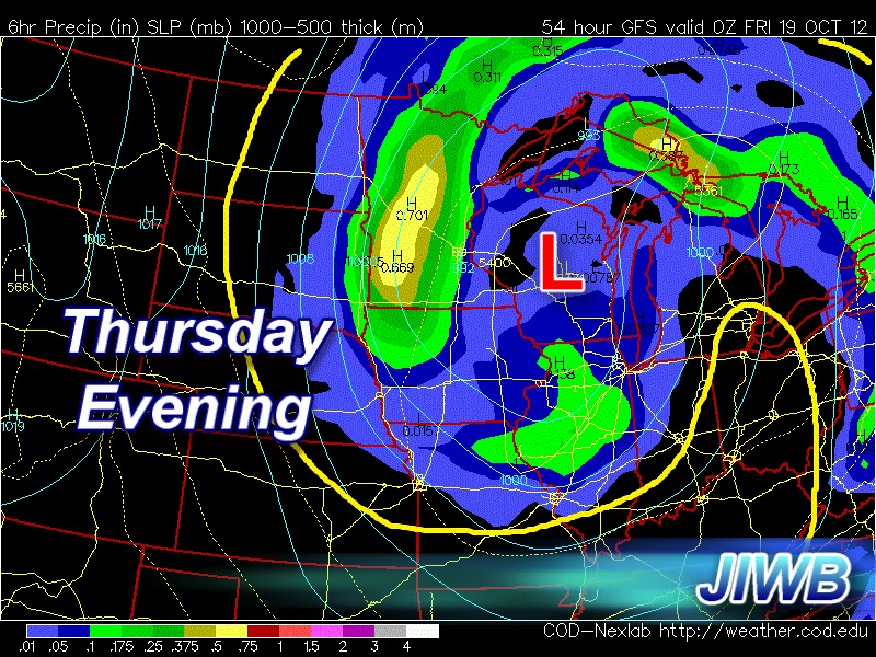
We will see a slight break in the rain and clouds as we form a dry slot in this system later on Thursday morning / early afternoon before that second half of the system catches us. You can see the dry slot in this model image above.
Thursday evening the clouds roll back into the area bringing whats left of the system. Scattered showers and a few gusty winds to 25 mph likely. Much cooler air will be in place Thursday and Friday after that cold front pushes through. Highs only in the 50s! As few spotty showers will linger into Friday off and on through out the day.
 
This storm almost looks like a hurricane on land. Its so big, it really is incredible looking!
Here's your forecast below.
WEDNESDAY- We will start out with partly cloudy skies across the area. Clouds and rain will move in as we head into the afternoon hours. Expect a high around 73* degrees with winds between 10 and 20 mph.
 
WEDNESDAY NIGHT- We will see rainy and windy conditions across the state. Rain will be heavy at times along with winds gusting to 25 and 38 mph. Look for a low around 42* degrees. Rainfall between .50" and .75" inches.
 
THURSDAY- We will see rain showers in the early early morning. However that will try to tapper off as we hit late morning. We will form a dry slot in this system giving way to partly cloudy skies during the afternoon hours. The second round of scattered showers will move into the area later on in the afternoon / early evening. Look for a chilly high around 59 * degrees and a low around 43* degrees. Winds between 10 and 15 mph gusting to 20 and 25 mph at times. Total rainfall between Wednesday and Thursday is looking between .50" and 1.50" inches. Slightly higher amounts in any thunderstorms.
 
EXTENDED OUTLOOK- Still some lingering spotty showers as we head into Friday. Otherwise mostly cloudy skies across the area. Friday will be another chilly day with a high in the lower to middle 50s. 50s and 60s will be our high as we finish off the work week. Clearing skies near the weekend!