What your looking at is our next severe weather event to move into the area. This system you see above has done such damage in areas of OK, it's terrible!!!! My thoughts and prayers are going out to everyone affected by the many tornadoes that touched down earlier this afternoon. It was pasted scary. I watched at least three live tornadoes on the weather channel earlier this evening. I have never seen so many tornadoes live on tv before. Again I'm praying for them all!! God Bless!
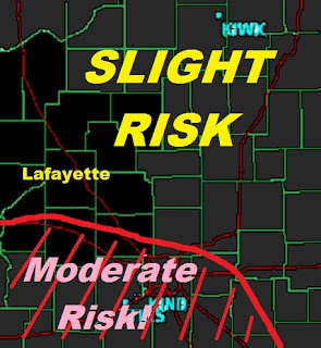
We will be tracking some scattered pop up thunderstorms across the area tomorrow. Or should I say today! (Wednesday). Starting this morning with more this afternoon / evening. We are in a slight risk for severe weather according to the Storm predication center. With some of our southern counties in that moderate risk. Take a look.
The green area is the Slight risk for severe. The Yellow area is the Moderate risk for severe weather.
Here is a closer zoom look below.
You can see most of us in that slight risk area with counties such as Montgomery, Fountain, and Boon, counties in that moderate risk area.
These storms will be off that line of storms you seen in the top radar image. So a few super cells are possible in the WLFI viewing area! However after going through some data I do believe that the strongest of storms will most likely set up just to the southwest of the WLFI viewing area. However this doesn't mean we're out of the woods. Take a look.
Just because I have the red area as the best chance for the strongest of storms today doesn't mean we won't see a few strong storms our self! This is just where the greatest threat for severe will be.
We are still looking at CAPE values around 2,000J/kg to 2,500J/kg along with EHI values between 2.7 to 3.0 which would support things such as:
Dangerous frequent lighting.
Small Hail Possible!
Gusty winds.
Heavy rainfall in storms. Rainfall between 0.50" to 0.75" Inches however expect higher amounts inside thunderstorms.
And an isolated tornado cannot totally be ruled out just yet!
~~~~~~~~~~~~~~~~~~~~~~~~
~~~~~~~~~~~~~~~~~~~~~~~~~~~~~~~
~~~~~~~~~~~~~~~~~~~~~~~~~~~~~~~
So you now know the details of our possible severe threat as we continue to head into our Wednesday. I will try to keep you posted the best I can. For now take care and God Bless!
Also please pray for everyone affected by all this severe weather to our west and southwest. They need all your help!
Thank you!


1 comment:
Thanks Justin! ALWAYS good to see an update from ya!
Post a Comment