Friday, February 22, 2013

After The Storm. Snowfall Totals!

This is a radar image taken at 10:53am EDT 11:53am EST. You can see the storm starting to make its way out of the area moving off to our east. We will see some of the melt down begin today with highs in the lower 40s along with a peak of sun here and there possible as we head into the afternoon hours.
Many areas picked up snow last night along with a glazing of ice. Here is a look at the West Lafayette, weather cam below. 
You can see the court house in a nice coating of sleet and snow this morning. Many woke up to that thin layer of ice on their cars across Indiana.
We had snow to start things last night as expected, Then mixing with some sleet and freezing rain to finish things off. Roads were VERY SLICK as I came home from work around 10pm. People were taking it nice and slow. It was like an ice rink in the Lafayette area.
 
Plows were doing the best they could to keep things clean and clear.
You can see some of the snow plowed up in this image above.
 
Here is a look at your final snowfall totals from around the area. Remember we called for 2" to 3" inches of snow from this system. Most areas picked up right around that 2" inch mark. Take a look.
 
Frankfort, 2.4" inches.
 
Covington, 2.0" inches.
 
Lafayette2.0" inches.
 
Remington, 2.0" inches.
 
Kentland, 2.0" inches.
 
Rensselaer, 1.8" inches.
 
West Lafayette, 1.2" inches.

 Stay safe bloggers, and be careful on the roads tonight as well, We will see a low around 20* degrees, so any water left standing on the roads will more then likely freeze! Take  care and as always God Bless!


Thursday, February 21, 2013

Rain, Sleet, Ice, and Snow! The Break Down And Timing.

...WINTER WEATHER ADVISORY REMAINS IN EFFECT FROM 7 PM THIS
EVENING TO 10 AM EST FRIDAY...
 
CARROLL-WARREN-TIPPECANOE-CLINTON-HOWARD-FOUNTAIN-MONTGOMERY-BOONE-TIPTON-HAMILTON-MADISON-DELAWARE-RANDOLPH-VERMILLION-PARKE-PUTNAM-HENDRICKS-MARION-HANCOCK-HENRY-VIGO-CLAY-OWEN-MORGAN-JOHNSON-SHELBY-RUSH-SULLIVAN-GREENE-MONROE-BROWN-BARTHOLOMEW-DECATUR-KNOX-DAVIESS-MARTIN-LAWRENCE-JACKSON-JENNINGS-INCLUDING THE CITIES OF...LAFAYETTE...FRANKFORT...KOKOMO...
CRAWFORDSVILLE...ANDERSON...MUNCIE...INDIANAPOLIS...TERRE HAUTE...
SHELBYVILLE...BLOOMINGTON...COLUMBUS...VINCENNES...BEDFORD...
SEYMOUR


PRECAUTIONARY/PREPAREDNESS ACTIONS...

A WINTER WEATHER ADVISORY MEANS THAT PERIODS OF SNOW...SLEET...OR
FREEZING RAIN WILL CAUSE TRAVEL DIFFICULTIES. BE PREPARED FOR
SLIPPERY ROADS AND LIMITED VISIBILITIES...AND USE CAUTION WHILE
DRIVING.
We have a big system tracking our way over the next few hours! With just about every type of winter precipitation possible. Snow, Sleet, and possible Freezing rain. The bufkit model below seems to be doing a pretty good job showing the timing and break down of what we can expect as we head into this evening and the overnight. Take a look.
Right now data is showing us starting out with a snow / sleet mix. Starting later this evening after 6:pm - 7:pm EST. As we go through the night we could mix in a little warmer air giving way to some sleet / freezing precipitation around midnight or so. Right now MOS models and Bufkit model are showing a possible 0.01" to 0.02" inches of ice out of this storm. With a possible snow / sleet accumulation between 2" and 3" inches.
 
We will see a low tonight around 27* degrees with breezy conditions, winds blowing between 20 and 25 mph. Tomorrow (Friday) we will start out the day with some lingering precipitation in the area. Otherwise mostly cloudy to partly cloudy skies with winds between 15 and 20 mph. A high around 41* degrees and a low that night around 26* degrees. So the good news here is that if we actually do pick up that possible 0.02" inches of ice, it will have some time to melt as we head into Friday afternoon.
Here's the break down image above.
 
I will keep watching this system bloggers. If you're like me and have to be at work tonight please drive safe and allow extra time to get where you need to be. Have a safe night and God Bless!

Wednesday, February 20, 2013

Tracking a wide range of winter precipitation over the next day and a half.

We have a system developing to our southwest that will eventually move our way giving way to a mix in winter precipitation. There is already a wide area in the central parts of the states with Winter storm advisories, watches, and warnings in effect. Areas in or around Nebraska, Kansas, and Missouri could easily pick up a good 12" to 15" inches of snowfall from this system when all is said and done.
 
Here in Indiana we are looking at a slightly different picture once this system rolls through. We will see a bit of everything according to current model runs. A wide mix of winter precipitation. Rain snow mix, sleet, and freezing rain are likely. I have not broke down the timing of this system just yet. I will have an update on that soon.
Stay tuned bloggers. Have a great day.

Monday, February 18, 2013

50s today, Tracking a rain to snow system this evening. How much snow??

We have another system we are tracking moving in from the west. A system developing along a cold front will give way to some heavy rain at times before changing over to some snow showers by later tonight into early Tuesday. Take a look at this image out of the National Weather Service below.
Today's weather story is mild temperatures in the lower 50s with breezy conditions. Wind between 20 and 25 mph gusting to 28 near 30 mph at times. This warm front you see above is what brings these mild temperatures before more bitter cold takes over.
 
Right now models are having a little trouble tracking the rain to snow change over. The timing of the change over will determine how much snowfall we actually see. Right now we're looking for rainfall to start later this evening between 6:pm and 8:pm EST. Rainfall between .25" and .50" inches. Models indicate the snow change over to be later on tonight after midnight. In this case we could pick up around 0.1" to 0.2" inches.
I don't want to make this my snow forecast just yet. Nothing is set in stone, I'd like to have a few more model runs under my belt. The sooner we change over to snow the more we will see. I highly doubt that we would see anymore then 1.50" inches at the very most! however 0.2" inches is seeming like the safe bet for now and is what I'm leaning toward.
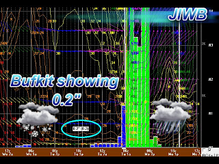
You can see that the Bufkit models are currently looking at a possible 0.2" inches as well. And Bufkit is usually pretty close when it comes to winter forecasting.
 
Here is a look at the developing system on national radar below. This image was taken at 11:53am EST.
I will have another quick update giving my final rainfall and snowfall forecast numbers later on tonight after more data comes in. So stay tuned and enjoy the 50s while they're here! Have a great day and as always God Bless.

Friday, February 15, 2013

More info on the meteor that struck Russia. Pictures and video of the impact!

This image above is actually the meteor path plotted on google maps. You can even see the contrail cloud left by the meteor before it struck Earth. 
(Above) A circular hole in the ice of Chebarkul Lake where a meteor reportedly struck the lake near Chelyabinsk, about 1500 kilometers (930 miles) east of Moscow, Russia, Friday, Feb. 15, 2013.
 
To help explain and understand just what meteoroids are and what the difference is between meteoroids and meteorites, I found a little information on the topic. Meteoroids are small pieces of space debris – usually parts of comets or asteroids – that are on a collision course with the Earth. They become meteors when they enter the Earth's atmosphere. Most meteors burn up in the atmosphere, but if they survive the frictional heating and strike the surface of the Earth they are called meteorites.
 
I found a video that is the only video I came across that actually lets you hear the sound of the meteor impacting the Earth. I warn you, this sound is like nothing you've ever heard before. This video and sound laterally gave me chills and goose bumps!

Yekaterina Melikhova, a high school student whose nose was bloody and whose upper lip was covered with a bandage, said she was in her geography class when a bright light flashed outside.
"After the flash, nothing happened for about three minutes. Then we rushed outdoors. The door was made of glass, a shock wave made it hit us," she said.
 
NASA is still looking into this historic event, trying to fully understand just what happened..
 
Whats your thoughts on this?

Snow And Meteors!?!? Meteor Hits Russia Feb 2013.

That's right we're waking up the day after Valentines day to SNOW! We expected a dusting of snow this morning however we did see just a bit more then that, Still under a half inch in Lafayette, area at this time. Right now I'm looking at around .2" inches in the greater Lafayette, area. Snow flakes coming down at nickel size this morning. A heavier band pushed through the Tippecanoe, county area. Take a look at my local radar image taken at 11:36am EST below.
You can see those darker blues and greens. This is the HEAVY bands of snow that pushed through the area which is why we saw more then a dusting this time around. The snow is starting to tapper off a bit as it continues to move to our east. Take a look at the huge snowflakes falling just a few short minutes ago in Lafayette.
I'm excited about this! :) If any of you have pictures please feel free to post them on the JIWB facebook page. They could even end up on here!
We woke up to the calm winter air with soft snow falling to the ground, However others today woke up to a VERY SCARY sight and sound! It has been brought to my attention that a meteor fell to earth just yesterday in Moscow! A meteor streaked across the sky and exploded over Russia's Ural Mountains with the power of an atomic bomb. Its sonic blasts shattered countless windows and injured nearly 1,000 people. The meteor was estimated to be about 10 tons when it entered the Earth's atmosphere at an unbelievable speed of at least 33,000 mph. It shattered into pieces about 18-32 miles above the ground. I couldn't even imagine what people were thinking when they saw such a big bright ball of light speeding toward the earth with such force and sound! That just sends chills down my spine..
 
Here is a video of the meter falling to earth that a few people actually caught on tape.
This is a scary event.

Here are more pictures.

Stay tuned bloggers, I'll check back soon. God Bless!

Wednesday, February 13, 2013

Hearts in the sky, It must be Valentines day :)

Love is in the air! Valentines day is tomorrow (Thursday the 14th). Its that time of year that we all go crazy with roses, candy, cards, etc! All to try and show our loved ones just how much we care. I remember last year with my girlfriend. We exchanged small meaningful gifts then went for a winter walk in the snow to the park. Hand in hand we enjoyed our evening. Our peaceful walked turned into a wild snowball fight lol :) finally we wrapped up our day with a nice quiet dinner. Its Valentines day's like that, that I will never forget.

So what will our weather be like for our loved ones this year? Well, lets take a look.
Right now I'm looking for a nice mix of clouds and sun through out the day. Breezy conditions with winds blowing between 10 and 20 mph, gusting between 25 and 28mph at times. A mild high for the day around 46* degrees with a low that night falling to 26* degrees. I cannot totally rule out a stray snow flurry or two later on in the day / evening. Really overall it looks like a nice day, wind aside.
 
We do have another system that we will watch as we move closer to Monday and Tuesday the 18th and 19th. A low pressure system will move up from the southwest giving way to what currently looks like snow. Some models already indicate a possible 1" to  2" inch range. However this is a way off so nothing is set in stone! I will keep you posted as we move closer.
 
Here's a look at our 3 - day forecast below.
Tonight expect a low around 30* degrees with calm winds between 5 and 10 mph. Partly cloudy skies through the night.
 
Thursday (Valentines day) a high of 46* and a low around 26* degrees. Breezy with mostly cloudy skies. Chc, of a stray flurry or two later.
 
Friday I'm calling for mostly cloudy skies through out the day with a high around 34* degrees and a low that night cold around 16* degrees. chance of a few scattered snow showers through out the day. Little to no snow accumulation expected. Anything we get would be a dusting if that much.
~~~~~~~~~~~~~~~~~~~~~~~~~~~~~~~~~~~~~~
~~~~~~~~~~~~~~~~~~~~~~~~~~~~~~~~~~~~~~~~~~~~~~~~

Here are a few Valentines Day fun facts in celebration of this special day below. Take a look and have a very happy valentines day. Take care bloggers and God Bless!
 
 Chocolate
  • Casanova, well known as "The World's Greatest Lover," ate chocolate to make him virile.
  • Physicians of the 1800s commonly advised their patients to eat chocolate to calm their pining for lost love.
  • Richard Cadbury produced the first box of chocolates for Valentine's Day in the late 1800s.
  • More than 35 million heart-shaped boxes of chocolate will be sold for Valentine's Day.
  • Over $1 billion worth of chocolate is purchased for Valentine's Day in the U.S. 
  • Flowers

    • 73 percent of people who buy flowers for Valentine's Day are men, while only 27 percent are women.
    • 15 percent of U.S. women send themselves flowers on Valentine's Day.

    Roses

    • The red rose was the favorite flower of Venus, the Roman goddess of love.
    • Red roses are considered the flower of love because the color red stands for strong romantic feelings.
    • 189 million stems of roses are sold in the U.S. on Valentine's Day. 
    Greeting Cards
    • Approximately 145 million valentines are sent in the U.S. each year according to estimates by the U.S. Greeting Card Association. That's second only to Christmas with 1.6 billion units, and is followed by Mother's Day with 133 million units.
    • Women purchase approximately 85 percent of all valentines.

    Tuesday, February 12, 2013

    Sundogs In The Sky!

    Sundogs!! First picture I have seen of them this year. How many do you see??
    This picture was taken February 9, 2013 from Jukkasjarvi, Sweden. Sundogs are caused when sunlight shines through either ice crystals, snow crystals, or tiny dust particles in the air. In this case it was most likely caused by snow crystals being kicked up into the air by sled dogs feet or snowmobiles. Whichever it is one thing is for sure, It's always a sight to see!
    we have another system we are tracking in the Indiana area by tomorrow. Nothing big or snowy at this time. You can see in this model image above. rain with a slight chance of a few stray flurries try to move in by tomorrow morning / early noon hours. currently this low pressure system looks to be tracking far enough south that we shouldn't have to worry about any precipitation this time around. partly cloudy skies through out most of the day tomorrow.
    Highs for Wednesday will be in the upper 40s. Around 46* degrees. A low Wednesday night around 31* degrees. As for valentines day I'm looking for a mix of sun and clouds through out the day. Dry and breezy with winds between 20 and 25 mph gusting to 28 mph at times. High mild around 47* degrees with a low that night around 25* degrees.
     
    I will have a more detailed valentines day forecast up for you all real soon. Have a great day.

    Sunday, February 10, 2013

    Temperature Flip Flop Season. Two Blizzards And Yet STILL No Snow For Us?!?!

    There has been a lot going on in the weather - world lately. We have had a blizzard in the northeast that is one for the record books! Snowfall measured with yard sticks! Snow over two feet deep in areas. We have had 60s and rain here in parts of the midwest with more rain today. And another blizzard in areas just northwest of Indiana in parts of Min and near by states! This has been crazy. Still with all this snow going around we have yet to get any!?!? I love winter and snow however this year has been a real disappointment for me weather - wise that is.
     
    Even now we have not snow, but more rain on the way. You can see in this radar image above taken at 11:45am EST. I'm expecting a good .25" to .50" inches of rainfall over the next few hours. Maybe even a rumble or two possible in areas. Like my girlfriend has said, "We keep having rain then it freezes, then more rain followed by more freezing." And this has been the story over the past month.
     
    Now as for the cold side of this storm. Take a look.
    Just a few hundred miles northwest of us you can see the colder side of things. Heavy heavy snowfall with high winds giving way to blizzard conditions in many areas. Here is what the National Weather Service has to say about this system for areas on the cold side of things.
     
    ...A BLIZZARD IS EXPECTED TONIGHT AND MONDAY OVER WESTERN MINNESOTA...
     
    TOTAL SNOW ACCUMULATIONS WILL RANGE FROM 7 TO 12 INCHES IN LOCATIONS THAT RECEIVE ALL SNOW...MAINLY WEST CENTRAL AND CENTRAL MINNESOTA. LOCALLY HIGHER AMOUNTS OF OVER A FOOT ARE POSSIBLE NEAR THE SOUTH DAKOTA BORDER.
     
    Just look at all the light and dark pinks in this image below. These are all the blizzard watches and warnings across the area this afternoon.
    6" to 12" inches of snowfall is expected in most areas to our northwest with locally higher amounts over a foot between 12" and 16" inches possible! Oh how I'd love to be seeing that in person. Makes me want to move west lol.
    As for that blizzard that just plowed through the northeast. Some areas picked up as much as 40" inches! Take a look at these final snowfall totals below. It's crazy! I've never seen this much snow in my life. Its a scary event as many have lost power. The force of nature is something to be taken seriously. Still, can you imagine how amazing that much snow would look in person? It'd be a sight that's for sure. something they will never forget.
     
    Connecticut:

    Hamden - 40.0 inches
    Milford - 38.0 inches
    Clintonville - 37.0 inches
    Oxford - 36.2 inches
    East Haddam - 35.5 inches
    Yalesville - 35.0 inches
    New Haven - 34.3 inches
    Gilford - 33.0 inches
    Manchester - 32.0 inches
    New York:

    Medford - 33.5 inches
    Upton - 30.9 inches
    Central Islip - 30.7 inches
    Commack - 29.1 inches
    Huntington - 29.0 inches
    Islip Airport - 27.8 inches
    Port Chester - 23.3 inches
    Yonkers - 23.0 inches
    Ardsley - 23.0 inches
    Scarsdale - 22.5 inches
    Plainview - 18.0 inches
    Middle Village - 15.0 inches
    Flushing - 11.0 inches
    La Guardia Airport - 12.1 inches
    Central Park - 11.4 inches
    Upper West Side - 10.9 inches
    Here is a photo of a car buried in the snow courtesy of Stephanie B. outside her home in Tewksbury, Mass. Just amazing! No words for this picture other then "Amazing".
     
    So what about us? Well, rain showers today into tonight. Expect rainfall between .25" and .50" inches with breezy conditions. Winds tonight between 15 and 20 mph gusting between 25 and 28mph. Low tonight of 35* degrees.
     
    Monday look for a high around 40* degrees with breezy conditions, winds between 15 and 20 mph gusting to 25 and 28mph. slight chance of a few light scattered snow flurries early in the day. Otherwise skies try to clear a bit becoming partly cloudy. Expect a low around 24* degrees.
     
    Tuesday I look for mostly sunny skies through out the day with a high in the low 40s and a low that night around 26* degrees.
    The cold temperatures once again make a comeback later in the week. Highs by Friday will only be in the 20s with lows in the teens! Friday through at least Sunday. This back and forth weather really takes its toll on the body. Please do your very best to stay warm and healthy during this crazy temperature flip flop season! The flu has been terrible this year. With most of the states in a wide spread outbreak. This constant temperature changes doesn't help that.
    Take care bloggers. And God Bless!

    Tuesday, February 5, 2013

    Crazy weather to start our new year. Another warm up on the way!

    We have had some crazy weather to start this new year. We have had 60s in January! followed by below zero temperatures only days later. Its been nuts! Well, what do we have in store over the next few days here in Indiana? you never know..
    Above is a look at the NAO models, its a long range forecasting tool that gives us a good idea what the weather will be like temperature - wise. Right now you can see the models are expecting the NAO to continue in a neutral phase over the next few days.

    the AO weather models also agree. They too are showing signs of a neutral phase heading into the next few weeks. This means both equal days of normal, above, and below average temperatures.
    Tonight we will be looking for chilly temperatures to move into the area, expect a low around 18* degrees. Winds light between 10 and 15 mph. This will give us a wind chill of around 7* degrees at times. Mostly clear skies will help us reach this nightly low of 18* degrees. Clearing skies means no blanket effect, and any warmer air we have at ground level will be able to escape.

    Here is a look at our three day outlook. 
    Wednesday highs will be in the lower to middle 30s with partly cloudy skies. A low that night around 23* degrees. clouds will be on the increase later Wednesday night into Thursday.

    Thursday we will look for a more mild high of 46* degrees with a few rain showers in the afternoon hours. Not expecting rain all day, skies will try to clear a bit as we head into the late afternoon / evening hours. Look for a low around 27* degrees. Currently expecting rainfall between .10" and .25" inches.

    We do have another round of warm temperatures trying to move into the area by the start of next week. Our average high for this time of year is right around 34* degrees. We could very well be a good 14* to 16* degrees above our average by Sunday into Monday. Highs will be pushing 50* degrees in areas! Take a look.
    Graph above is looking into Sunday's high.
    So a few more chilly days before yet another warm up near 50* degrees. Rain showers by Thursday. That's it for now bloggers. Have a great day and as always, God Bless!

    DEVELOPING POST!

    Hey bloggers, I'm sorry for the lack in updates lately. I have been very busy. I will have a new post up later on tonight though I promise! Stay tuned and God Bless!